Skip header and navigation

Revise Search

20 records – page 2 of 1.

Aerial view: Brandon College looking northwest

http://archives.brandonu.ca/en/permalink/descriptions599
Part Of
Aerial views and campus photographs
Description Level
Item
GMD
graphic
Date Range
late 1960s
Part Of
Aerial views and campus photographs
Description Level
Item
Series Number
2.1
Item Number
2.1.7
GMD
graphic
Date Range
late 1960s
Physical Description
5" x 4" (b/w)
Scope and Content
Brandon College. Looking north west over the valley after 1963 Music Building opening, but before trees were moved to the quadrangle.
Images
Show Less

Aerial view: Brandon College tree planting

http://archives.brandonu.ca/en/permalink/descriptions604
Part Of
Aerial views and campus photographs
Description Level
Item
GMD
graphic
Date Range
c. 1964
Part Of
Aerial views and campus photographs
Description Level
Item
Series Number
2.1
Item Number
2.1.11
GMD
graphic
Date Range
c. 1964
Physical Description
5" x 4" (b/w)
Scope and Content
View is east northeast from approximately 22nd Street between Lorne and Louise Avenues. Photograph shows: Brandon College (before planting of trees in quadrangle and before the Education Building), McKenzie Seeds, Prince Edward Hotel, Central United (St. Paul's) Church, St. Augustine's Church.
Images
Show Less

Aerial view: Brandon College looking east

http://archives.brandonu.ca/en/permalink/descriptions617
Part Of
Aerial views and campus photographs
Description Level
Item
GMD
graphic
Date Range
c. 1963
Part Of
Aerial views and campus photographs
Description Level
Item
Series Number
2.1
Item Number
2.1.25
GMD
graphic
Date Range
c. 1963
Physical Description
5" x 4" (b/w)
Scope and Content
View is east from approximatley 22nd Street between Lorne and Louise Avenues. Photograph shows: Darrach Hall, Flora Cowan Hall and the Citizens' Science Building, as well as a number of homes in the area.
Images
Show Less

Aerial view: Brandon College and Original Music Building

http://archives.brandonu.ca/en/permalink/descriptions603
Part Of
Aerial views and campus photographs
Description Level
Item
GMD
graphic
Date Range
c. 1965
Part Of
Aerial views and campus photographs
Description Level
Item
Series Number
2.1
Item Number
2.1.10
GMD
graphic
Date Range
c. 1965
Physical Description
5" x 4" (b/w)
Scope and Content
View is west southwest from 17th Street and Princess Avenue. Photograph shows: Clark Hall, A.E. McKenzie Building and original Music Building.
Images
Show Less

Aerial view: Brandon College campus from north

http://archives.brandonu.ca/en/permalink/descriptions615
Part Of
Aerial views and campus photographs
Description Level
Item
GMD
graphic
Date Range
c. 1963
Part Of
Aerial views and campus photographs
Description Level
Item
Series Number
2.1
Item Number
2.1.23
GMD
graphic
Date Range
c. 1963
Physical Description
5" x 4" (b/w)
Scope and Content
View is north, taken from approximatley 19th Street and Rosser Avenue. Photograph shows: Clark Hall, the A.E. McKenzie Building, the J.R.C. Evans Lecture Theatre, H-Huts, Darrach Hall and Flora Cowan Hall, as well as a number of homes in the area.
Images
Show Less

Aerial view: Brandon College campus looking northwest

http://archives.brandonu.ca/en/permalink/descriptions616
Part Of
Aerial views and campus photographs
Description Level
Item
GMD
graphic
Date Range
c. 1963
Part Of
Aerial views and campus photographs
Description Level
Item
Series Number
2.1
Item Number
2.1.24
GMD
graphic
Date Range
c. 1963
Physical Description
5" x 4" (b/w)
Scope and Content
View is northwest from approximately the corner of 18th Street and Louise Avenue. Photograph shows the Brandon College campus after the completion of Flora Cowan Hall.
Notes
BUPC 2.1.20 is a larger version of this photograph.
Images
Show Less

Aerial view: Brandon College campus and Kinsmen Park

http://archives.brandonu.ca/en/permalink/descriptions621
Part Of
Aerial views and campus photographs
Description Level
Item
GMD
graphic
Date Range
c. 1962
Part Of
Aerial views and campus photographs
Description Level
Item
Series Number
2.1
Item Number
2.1.19
GMD
graphic
Date Range
c. 1962
Physical Description
10" x 8" (b/w)
Physical Condition
The bottom right hand corner has been torn off. Both portions of the photograph are stored together.
Scope and Content
View is northwest from approximately 17th Street and Victoria Avenue. Photograph shows: the Brandon College campus and the Kinsmen Park and baseball diamond. Taken during construction of Flora Cowan Hall but before the Gymnasium was built.
Images
Show Less

Citizens' Science Building, Brandon College Building and Clark Hall

http://archives.brandonu.ca/en/permalink/descriptions816
Part Of
Aerial views and campus photographs
Description Level
Item
GMD
graphic
Date Range
October 1981
Part Of
Aerial views and campus photographs
Description Level
Item
Series Number
2.1
Item Number
2.1.142
GMD
graphic
Date Range
October 1981
Physical Description
8" x 10" (b/w)
Scope and Content
Photograph is looking northwest probably from the John R. Brodie Science Centre and shows the Citzens' Science Building, the Brandon College Building, Clark Hall and a portion of the driveway and grounds in front of the buildings.
Images
Show Less
Part Of
Alf Fowler collection
Description Level
Item
GMD
graphic
Date Range
ca. 1911
Accession Number
6-1999
Part Of
Alf Fowler collection
Creator
Davidson & Gowen
Description Level
Item
Item Number
6-1999.46
Accession Number
6-1999
GMD
graphic
Date Range
ca. 1911
Physical Description
9" x 7" (b/w)
History / Biographical
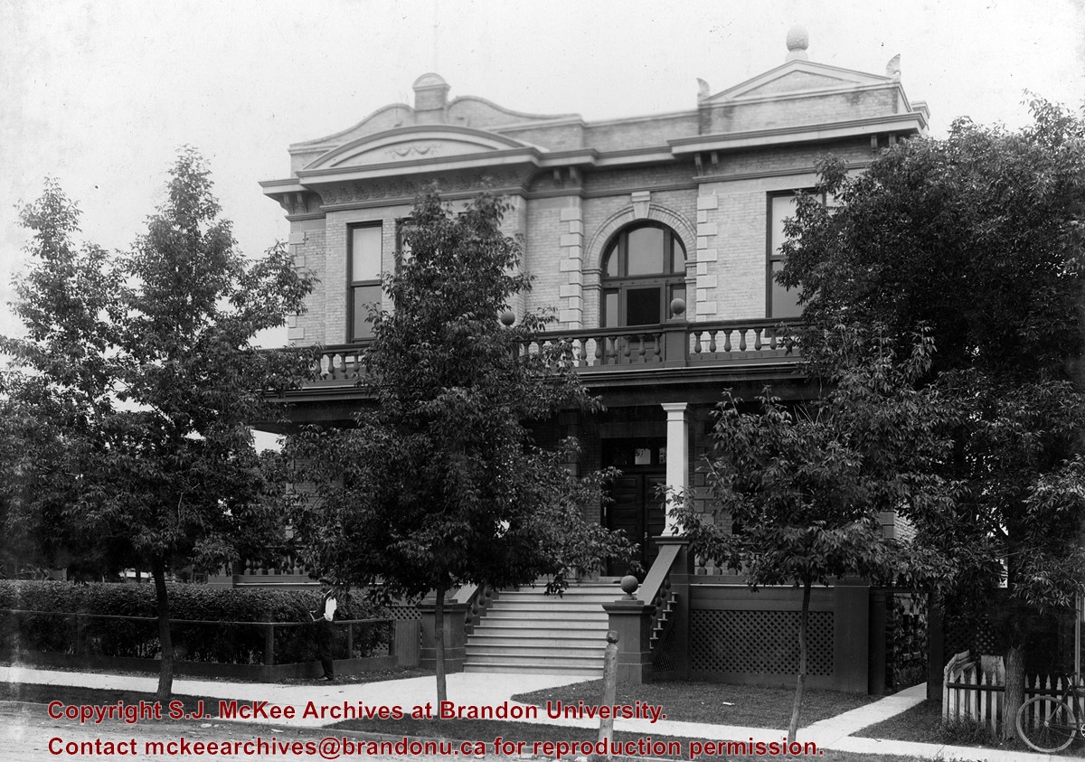
The Brandon Club, designed in 1904 by local architect and builder W.R. Marshall, was Brandon's oldest chartered club. It was located at 158 11th Street. In the early years as an exclusive institution, the club boased such notable members as Sir Clifford Sifton, Senator J.N. Kirchoffer, and Sir R.P. Roblin. The Brandon Club closed its doors c. 2005. At present (June 2007), it is the future home of Lennon Trilogy, professional land surveyors.
Custodial History
See fonds level description of the Alf Fowler collection for custodial history.
Scope and Content
Photo shows the exterior of the Brandon Club. Photograph is looking west.
Notes
History/Bio information taken from the Assiniboine Historical Society's Brandon: An Architectural Walking Tour pamphlet (1982).
Storage Range
RG 5 Western Manitoba Manuscript collection - photograph storage drawer
Images
Show Less
Part Of
Alf Fowler collection
Description Level
Item
GMD
graphic
Date Range
ca. 1911
Accession Number
6-1999
Part Of
Alf Fowler collection
Creator
Davidson & Gowen
Description Level
Item
Item Number
6-1999.97
Accession Number
6-1999
GMD
graphic
Date Range
ca. 1911
Physical Description
9.25" x 7.25" (b/w)
Custodial History
See fonds level description of the Alf Fowler collection for custodial history.
Scope and Content
Photo shows a Brandon residence located at 436 Victoria Avenue.
Storage Range
RG 5 Western Manitoba Manuscript collection - photograph storage drawer
Images
Show Less
Part Of
Alf Fowler collection
Description Level
Item
GMD
graphic
Date Range
ca. 1911
Accession Number
6-1999
Part Of
Alf Fowler collection
Creator
Davidson & Gowen
Description Level
Item
Item Number
6-1999.98
Accession Number
6-1999
GMD
graphic
Date Range
ca. 1911
Physical Description
9.25" x 7.25" (b/w)
Custodial History
See fonds level description of the Alf Fowler collection for custodial history.
Scope and Content
Photo shows a Brandon residence located at 134 Louise Avenue.
Storage Range
RG 5 Western Manitoba Manuscript collection - photograph storage drawer
Images
Show Less
Part Of
Alf Fowler collection
Description Level
Item
GMD
graphic
Date Range
ca. 1911
Accession Number
6-1999
Part Of
Alf Fowler collection
Creator
Davidson & Gowen
Description Level
Item
Item Number
6-1999.100
Accession Number
6-1999
GMD
graphic
Date Range
ca. 1911
Physical Description
9.25" x 7.25" (b/w)
Custodial History
See fonds level description of the Alf Fowler collection for custodial history.
Scope and Content
Photo shows a Brandon residence.
Storage Range
RG 5 Western Manitoba Manuscript collection - photograph storage drawer
Images
Show Less
Part Of
Alf Fowler collection
Description Level
Item
GMD
graphic
Date Range
ca. 1911
Accession Number
6-1999
Part Of
Alf Fowler collection
Creator
Davidson & Gowen
Description Level
Item
Item Number
6-1999.101
Accession Number
6-1999
GMD
graphic
Date Range
ca. 1911
Physical Description
9.25" x 7.25" (b/w)
Custodial History
See fonds level description of the Alf Fowler collection for custodial history.
Scope and Content
Photo shows a Brandon residence.
Storage Range
RG 5 Western Manitoba Manuscript collection - photograph storage drawer
Images
Show Less
Part Of
Alf Fowler collection
Description Level
Item
GMD
graphic
Date Range
ca. 1911
Accession Number
6-1999
Part Of
Alf Fowler collection
Creator
Davidson & Gowen
Description Level
Item
Item Number
6-1999.102
Accession Number
6-1999
GMD
graphic
Date Range
ca. 1911
Physical Description
9.25" x 7.25" (b/w)
Custodial History
See fonds level description of the Alf Fowler collection for custodial history.
Scope and Content
Photo shows a Brandon residence.
Storage Range
RG 5 Western Manitoba Manuscript collection - photograph storage drawer
Images
Show Less
Part Of
Alf Fowler collection
Description Level
Item
GMD
graphic
Date Range
ca. 1911
Accession Number
6-1999
Part Of
Alf Fowler collection
Creator
Davidson & Gowen
Description Level
Item
Item Number
6-1999.103
Accession Number
6-1999
GMD
graphic
Date Range
ca. 1911
Physical Description
9.25" x 7.25" (b/w)
Custodial History
See fonds level description of the Alf Fowler collection for custodial history.
Scope and Content
Photo shows a Brandon residence.
Storage Range
RG 5 Western Manitoba Manuscript collection - photograph storage drawer
Images
Show Less
Part Of
Alf Fowler collection
Description Level
Item
GMD
graphic
Date Range
ca. 1911
Accession Number
6-1999
Part Of
Alf Fowler collection
Creator
Davidson & Gowen
Description Level
Item
Item Number
6-1999.105
Accession Number
6-1999
GMD
graphic
Date Range
ca. 1911
Physical Description
9.25" x 7.25" (b/w)
Custodial History
See fonds level description of the Alf Fowler collection for custodial history.
Scope and Content
Photo shows a Brandon residence.
Storage Range
RG 5 Western Manitoba Manuscript collection - photograph storage drawer
Images
Show Less
Part Of
Alf Fowler collection
Description Level
Item
GMD
graphic
Date Range
ca. 1911
Accession Number
6-1999
Part Of
Alf Fowler collection
Creator
Davidson & Gowen
Description Level
Item
Item Number
6-1999.104
Accession Number
6-1999
GMD
graphic
Date Range
ca. 1911
Physical Description
9.25" x 7.25" (b/w)
Custodial History
See fonds level description of the Alf Fowler collection for custodial history.
Scope and Content
Photo shows a Brandon residence located at 208 Louise Avenue.
Storage Range
RG 5 Western Manitoba Manuscript collection - photograph storage drawer
Images
Show Less

Brandon University campus

http://archives.brandonu.ca/en/permalink/descriptions771
Part Of
Aerial views and campus photographs
Description Level
Item
GMD
graphic
Date Range
c. 1980
Part Of
Aerial views and campus photographs
Description Level
Item
Series Number
2.1
Item Number
2.1.31
GMD
graphic
Date Range
c. 1980
Physical Description
5" x 4" (b/w)
Scope and Content
View is southwest from approximately 18th Street and Lorne Avenue. Photograph shows the Brandon University campus in winter, including: the Brandon University sign, the John R. Brodie Science Centre, the Citizens' Science Building and McMaster Hall.
Images
Show Less

Brandon University campus

http://archives.brandonu.ca/en/permalink/descriptions779
Part Of
Aerial views and campus photographs
Description Level
Item
GMD
graphic
Date Range
c. late 1970s
Part Of
Aerial views and campus photographs
Description Level
Item
Series Number
2.1
Item Number
2.1.46
GMD
graphic
Date Range
c. late 1970s
Physical Description
7" x 5" (colour)
Scope and Content
View is southwest from the north side of Princess Avenue. Photograph shows the original Music Building, the north driveway entrance and parts of Clark Hall and the Brandon College building.
Images
Show Less

Brandon University campus

http://archives.brandonu.ca/en/permalink/descriptions788
Part Of
Aerial views and campus photographs
Description Level
Item
GMD
graphic
Date Range
c. 1975
Part Of
Aerial views and campus photographs
Description Level
Item
Series Number
2.1
Item Number
2.1.47
GMD
graphic
Date Range
c. 1975
Physical Description
5" x 5" (b/w)
Scope and Content
View is southwest from the sidewalk on the west side of 18th Street. Photograph shows the Brandon University sign, the front lawn, the Citizens' Science Building, McMaster Hall and the John R. Brodie Science Centre.
Images
Show Less

20 records – page 2 of 1.