Skip header and navigation

Revise Search

20 records – page 2 of 1.

Aerial view: Brandon College Building

http://archives.brandonu.ca/en/permalink/descriptions606
Part Of
Aerial views and campus photographs
Description Level
Item
GMD
graphic
Date Range
c. 1988
Part Of
Aerial views and campus photographs
Description Level
Item
Series Number
2.1
Item Number
2.1.13
GMD
graphic
Date Range
c. 1988
Physical Description
3.5" x 5" (colour)
Scope and Content
View is north northeast. Photograph shows the Brandon College Building in the foreground with the Education Building and North Hill in the background. Photo was taken from the roof of McMaster Hall.
Images
Show Less

Aerial view: Citizens' Science Building

http://archives.brandonu.ca/en/permalink/descriptions611
Part Of
Aerial views and campus photographs
Description Level
Item
GMD
graphic
Date Range
c. 1980s
Part Of
Aerial views and campus photographs
Description Level
Item
Series Number
2.1
Item Number
2.1.21
GMD
graphic
Date Range
c. 1980s
Physical Description
5" x 3.5" (b/w)
Scope and Content
View is northwest, taken from the John R. Brodie Science Centre. Photograph shows: Citizens' Science Building in the foreground, the Brandon College Building and Clark Hall in the background, as well as the driveway in front of the buildings.
Images
Show Less

Aerial view: Clark Hall, Education Building, Student Union Building

http://archives.brandonu.ca/en/permalink/descriptions612
Part Of
Aerial views and campus photographs
Description Level
Item
GMD
graphic
Date Range
c. 1960s
Part Of
Aerial views and campus photographs
Description Level
Item
Series Number
2.1
Item Number
2.1.17
GMD
graphic
Date Range
c. 1960s
Physical Description
10" x 8" (b/w)
Scope and Content
View is northeast, taken from the John R. Brodie Science Centre. Photograph shows: the Brandon College Building, the Student Services H-Hut, the Education Building, and the Student Union Building (Citizens' Science Building), as well as 18th Street and some houses. The trailer to the south of the Education Building was a Canada Manpower office in the 1960s. It was latter moved over by the Gymnasium, where it became the Quill office.
Images
Show Less

A.E. McKenzie Building construction

http://archives.brandonu.ca/en/permalink/descriptions627
Part Of
Brandon University Photograph collection
Description Level
Item
GMD
graphic
Date Range
[1959-1960]
Part Of
Brandon University Photograph collection
Description Level
Item
Series Number
2.4
Item Number
BUPC 2.4.6
GMD
graphic
Date Range
[1959-1960]
Physical Description
5" x 7" (b/w)
Scope and Content
Photograph is looking northeast (?) and shows the construction of the A.E. McKenzie Building (Library and Arts Building) during the winter.
Subject Access
campus buildings
Images
Show Less

A.E. McKenzie Building construction

http://archives.brandonu.ca/en/permalink/descriptions628
Part Of
Brandon University Photograph collection
Description Level
Item
GMD
graphic
Date Range
[1959-1960]
Part Of
Brandon University Photograph collection
Description Level
Item
Series Number
2.4
Item Number
BUPC 2.4.7
GMD
graphic
Date Range
[1959-1960]
Physical Description
5" x 7" (b/w)
Scope and Content
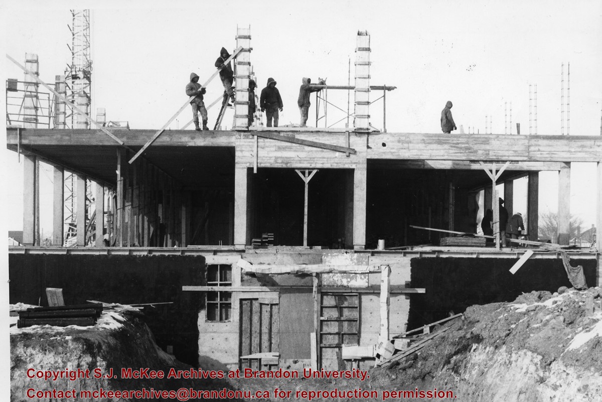
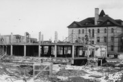
Photograph is looking either north or south into the A.E. McKenzie Building (Library and Arts Building) during construction. A number of the members of the construction crew are visible.
Images
Show Less

A.E. McKenzie Building construction

http://archives.brandonu.ca/en/permalink/descriptions629
Part Of
Brandon University Photograph collection
Description Level
Item
GMD
graphic
Date Range
[1959-1960]
Part Of
Brandon University Photograph collection
Description Level
Item
Series Number
2.4
Item Number
BUPC 2.4.8
GMD
graphic
Date Range
[1959-1960]
Physical Description
5" x 7" (b/w)
Scope and Content
Photograph shows the construction of the A.E. McKenzie Building (Library and Arts Building) during winter.
Images
Show Less

A.E. McKenzie Building construction

http://archives.brandonu.ca/en/permalink/descriptions630
Part Of
Brandon University Photograph collection
Description Level
Item
GMD
graphic
Date Range
[1959-1960]
Part Of
Brandon University Photograph collection
Description Level
Item
Series Number
2.4
Item Number
BUPC 2.4.9
GMD
graphic
Date Range
[1959-1960]
Physical Description
5" x 7" (b/w)
Scope and Content
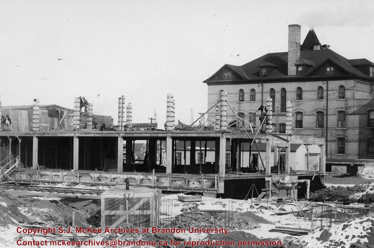
Photograph is looking east northeast and shows the construction of the A.E. McKenzie Building (Library and Arts Building). Clark Hall is in the background.
Images
Show Less

A.E. McKenzie Building opening

http://archives.brandonu.ca/en/permalink/descriptions631
Part Of
Brandon University Photograph collection
Description Level
Item
GMD
graphic
Date Range
January 6, 1961
Part Of
Brandon University Photograph collection
Description Level
Item
Series Number
2.4
Item Number
BUPC 2.4.10
GMD
graphic
Date Range
January 6, 1961
Physical Description
9" x 7" (b/w)
Scope and Content
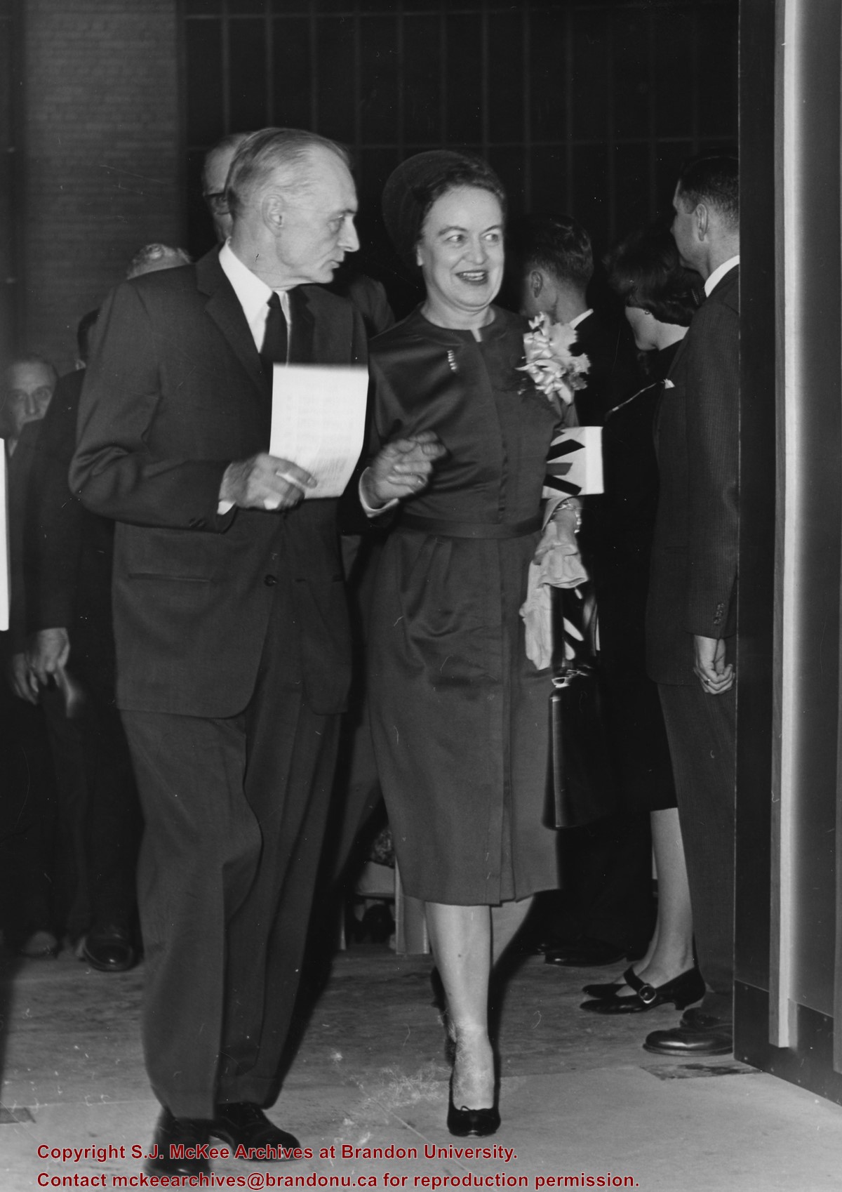
Photograph was taken at the opening of the A.E. McKenzie Building (including the Evans Theatre) and shows the J.R.C. Evans Lecture Theatre doorway. L to R Dr. John E. Robbins, Mrs. Olive (Freeman) Diefenbaker (Class of 1923 and wife of Prime Minister John George Diefenbaker)
Notes
The opening of the A.E. McKenzie Building took place the same day as the installation of John E. Robbins as President of Brandon College.
Images
Show Less

Aerial view: Brandon College and Original Music Building

http://archives.brandonu.ca/en/permalink/descriptions603
Part Of
Aerial views and campus photographs
Description Level
Item
GMD
graphic
Date Range
c. 1965
Part Of
Aerial views and campus photographs
Description Level
Item
Series Number
2.1
Item Number
2.1.10
GMD
graphic
Date Range
c. 1965
Physical Description
5" x 4" (b/w)
Scope and Content
View is west southwest from 17th Street and Princess Avenue. Photograph shows: Clark Hall, A.E. McKenzie Building and original Music Building.
Images
Show Less

North side of the A.E. McKenzie Building

http://archives.brandonu.ca/en/permalink/descriptions770
Part Of
Brandon University Photograph collection
Description Level
Item
GMD
graphic
Date Range
c. mid 1980s
Part Of
Brandon University Photograph collection
Description Level
Item
Series Number
2.4
Item Number
BUPC 2.4.3
GMD
graphic
Date Range
c. mid 1980s
Physical Description
3.5" x 5" (colour)
Scope and Content
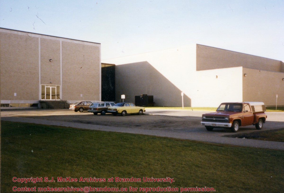
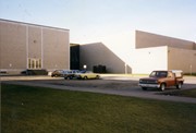
Photograph is looking southwest from in front of the Original Music Building and shows the north side of the A.E. McKenzie Building and the west side of the Queen Elizabeth II Music Building (including the link). A number of cars in the parking lot are also visible.
Images
Show Less

A.E. McKenzie Building cornerstone laying advertisement

http://archives.brandonu.ca/en/permalink/descriptions632
Part Of
Brandon University Photograph collection
Description Level
Item
GMD
graphic
Date Range
May 29, 1960
Part Of
Brandon University Photograph collection
Description Level
Item
Series Number
2.4
Item Number
BUPC 2.4.11
GMD
graphic
Date Range
May 29, 1960
Physical Description
8" x 10" (b/w)
Scope and Content
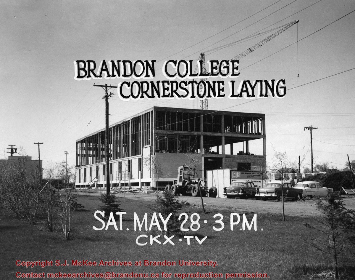
Photograph is looking southwest and shows the A.E. McKenzie Building under construction. In black lettering above the building are the words: "Brandon College Cornerstone Laying." In white lettering below the building are the words: "Sat. May 28 - 3 pm CKX TV"
Notes
The Winnipeg Tribune is stamped on the back of the photograph.
Images
Show Less

Aerial view: Brandon College

http://archives.brandonu.ca/en/permalink/descriptions594
Part Of
Brandon University Photograph collection
Description Level
Item
GMD
graphic
Date Range
[fall 1964?]
Part Of
Brandon University Photograph collection
Description Level
Item
Series Number
2.1
Item Number
BUPC 2.1.2
GMD
graphic
Date Range
[fall 1964?]
Physical Description
5" x 4" (b/w)
Scope and Content
Brandon College looking south from 19th Street. Photograph was taken after Flora Cowan Hall was built but before construction of the Education Building.
Subject Access
aerial photographs
campus photographs
campus buildings
Brandon streets
Images
Show Less

Aerial view: Brandon University campus

http://archives.brandonu.ca/en/permalink/descriptions605
Part Of
Aerial views and campus photographs
Description Level
Item
GMD
graphic
Date Range
c. 1969
Part Of
Aerial views and campus photographs
Description Level
Item
Series Number
2.1
Item Number
2.1.12
GMD
graphic
Date Range
c. 1969
Physical Description
3.5" x 3.5" (b/w)
Scope and Content
View is northeast. Brandon University campus and some of the surrounding residential areas.
Images
Show Less

Aerial view: Brandon University campus

http://archives.brandonu.ca/en/permalink/descriptions607
Part Of
Aerial views and campus photographs
Description Level
Item
GMD
graphic
Date Range
c. 1970
Part Of
Aerial views and campus photographs
Description Level
Item
Series Number
2.1
Item Number
2.1.14
GMD
graphic
Date Range
c. 1970
Physical Description
5" x 3" (b/w)
Scope and Content
View is north northwest from the roof of Flora Cowan Hall (?). Photograph shows: the J.R.C. Evans Lecture Theatre, the A.E. McKenzie Building and the Western Manitoba Centennial Auditorium as well as a number of houses on 20th Street.
Images
Show Less

Aerial view: Brandon University campus

http://archives.brandonu.ca/en/permalink/descriptions618
Part Of
Aerial views and campus photographs
Description Level
Item
GMD
graphic
Date Range
c. 1969
Part Of
Aerial views and campus photographs
Description Level
Item
Series Number
2.1
Item Number
2.1.26
GMD
graphic
Date Range
c. 1969
Physical Description
3.5" x 3.5" (b/w)
Scope and Content
Taken from an airplane, photograph is looking northwest from approximatley 15th Street and Louise Avenue. Shown are a number of residential blocks, the Brandon University campus, the railroad tracks and the Assiniboine River to approximatley 34th Street.
Images
Show Less

Aerial view: Brandon University campus

http://archives.brandonu.ca/en/permalink/descriptions619
Part Of
Aerial views and campus photographs
Description Level
Item
GMD
graphic
Date Range
c. 1969
Part Of
Aerial views and campus photographs
Description Level
Item
Series Number
2.1
Item Number
2.1.27
GMD
graphic
Date Range
c. 1969
Physical Description
3.5" x 3.5" (b/w)
Scope and Content
Taken from an airplane, photograph is looking north northwest from almost right above the Brandon University campus.
Images
Show Less

Aerial view: Brandon University campus

http://archives.brandonu.ca/en/permalink/descriptions620
Part Of
Aerial views and campus photographs
Description Level
Item
GMD
graphic
Date Range
c. 1969
Part Of
Aerial views and campus photographs
Description Level
Item
Series Number
2.1
Item Number
2.1.28
GMD
graphic
Date Range
c. 1969
Physical Description
3.5" x 3.5" (b/w)
Scope and Content
Taken from an airplane, photograph is looking north from approximately Louise Avenue between 18th and 20th Streets.
Notes
Photograph is slightly out of focus.
Show Less

Aerial view: Brandon College campus

http://archives.brandonu.ca/en/permalink/descriptions622
Part Of
Aerial views and campus photographs
Description Level
Item
GMD
graphic
Date Range
c. 1962
Part Of
Aerial views and campus photographs
Description Level
Item
Series Number
2.1
Item Number
2.1.20
GMD
graphic
Date Range
c. 1962
Physical Description
10" x 8" (b/w)
Scope and Content
View is northwest from approximately the corner of 18th Street and Louise Avenue. Photograph shows the Brandon College campus after the completion of Flora Cowan Hall.
Notes
BUPC 2.1.24 is a smaller version of this photograph.
Images
Show Less

Aerial view - Brandon University campus

http://archives.brandonu.ca/en/permalink/descriptions7989
Part Of
Brandon University Photograph collection
Description Level
Item
GMD
graphic
Date Range
c. 2000
Part Of
Brandon University Photograph collection
Creator
Photograph commissioned by Brandon University and taken by Yourview Aerial Scenics Ltd.
Description Level
Item
Series Number
2.1
Item Number
BUPC 2.1.55
GMD
graphic
Date Range
c. 2000
Physical Description
6" x 4" (colour)
Scope and Content
View is southwest from approximatley 16th Street between Princess and Rosser Avenues. Photograph shows the Brandon University campus, as well as surrounding residential blocks, including Flemming, J.R. Reid and Vincent Massey schools.
Subject Access
aerial photographs
campus photographs
campus buildings
Brandon streets
Images
Show Less

Aerial view - Brandon University campus

http://archives.brandonu.ca/en/permalink/descriptions7990
Part Of
Brandon University Photograph collection
Description Level
Item
GMD
graphic
Date Range
c. 2000
Part Of
Brandon University Photograph collection
Creator
Photograph commissioned by Brandon University and taken by Yourview Aerial Scenics Ltd.
Description Level
Item
Series Number
2.1
Item Number
BUPC 2.1.56
GMD
graphic
Date Range
c. 2000
Physical Description
6" x 4" (colour)
Scope and Content
View is west southwest from approximatley 16th Street between Princess and Lorne Avenues. Photograph shows the Brandon University campus, as well as surrounding residential blocks between 16th and 23rd Streets, Princess and Louise Avenues..
Subject Access
aerial photographs
campus photographs
campus buildings
Brandon streets
Images
Show Less

20 records – page 2 of 1.