Skip header and navigation

Revise Search

20 records – page 3 of 1.

Aerial View of Core Area

http://archives.brandonu.ca/en/permalink/descriptions9268
Part Of
RG 11 Lawrence Stuckey fonds
Description Level
Item
GMD
graphic
Date Range
1977
Accession Number
1-2002
Part Of
RG 11 Lawrence Stuckey fonds
Creator
D.L. Bottley
Description Level
Item
Series Number
3.1
Item Number
1-2002.3.1CA19(2)
Accession Number
1-2002
GMD
graphic
Date Range
1977
Physical Description
3 1/2" x 5"
Material Details
Negative
Custodial History
For custodial history see the collection level description of the Lawrence Stuckey collection.
Scope and Content
Aerial view of Brandon's core area
Notes
[Mr. Stuckey put 2 negatives in the same envelope. We have separated them and numbered them CA19(1) and CA19(2).]
Name Access
Aerial View of Core Area
Subject Access
downtowns
aerial photography
Brandon Street Scenes After 1940
Repro Restriction
The McKee Archives is the copyright holder for the Stuckey materials.
Storage Location
Lawrence Stuckey collection
Images
Show Less

Aerial view of 10th Street facing south from Princess Avenue

http://archives.brandonu.ca/en/permalink/descriptions8420
Part Of
Joseph H. Hughes collection
Description Level
Item
GMD
graphic
Date Range
c.1940
Accession Number
3-1997
Part Of
Joseph H. Hughes collection
Creator
Photographer: Jerrett Photo
Description Level
Item
Series Number
3-1997.1
Item Number
3-1997.1.42
Accession Number
3-1997
GMD
graphic
Date Range
c.1940
Physical Description
5.5" x 3.5" (b/w)
Material Details
postcard
Physical Condition
Red ink stain is on the front right corner of postcard
Scope and Content
Photograph shows 10th Street facing south from Princess Avenue. Visible landmarks and businesses include: Manitoba Power Commission (MPC)'s power sub-station, First Baptist Church, Wheat City Arena, and the grand stand at the Exhibition Grounds. The partial sign visible at the bottom of the photograph on the east side of 10th Street reads Yates and Neale, which refers to a plumbing and heating company that dissolved in 1943 to be replaced by Neale, Stothard and Chapman. Businesses on the west side of 10th Street include: Dominion Tire & Radio Co., Bolts Barber Shop, Elviss T.E. Co. Stables.
Notes
Information concerning Yates and Neale courtesy Jack Stothard. Writing on the front of the postcard reads: Brandon, Looking S.W., Jerrett Photo. This photograph shows a rare view of the 200-block of 10th Street.
Name Access
Manitoba Power Company
10th Street
Dominion Tire & Radio Co.
T.E. Elviss Co. Stables
First Baptist Church
Subject Access
downtowns
street scenes
Brandon business buildings & facilities before 1940
aerial views
building exteriors
residences
churches
Storage Location
RG 5 photograph storage drawer
Images
Show Less
Part Of
Brandon University Photograph collection
Description Level
Item
GMD
graphic
Date Range
May 12, 1992
Part Of
Brandon University Photograph collection
Description Level
Item
Series Number
2.1
Item Number
BUPC 2.1.62
GMD
graphic
Date Range
May 12, 1992
Physical Description
5.75" x 3.75" (colour)
Scope and Content
Photograph shows a backhoe digging a sewer hole near the sidewalk between the Brandon College Building and the Citizens' Science Building. The Knowles-Douglas Students' Union Centre, John R. Brodie Science Centre and a portion of the driveway are visible in the background.
Subject Access
campus photographs
campus buildings
campus construction
Images
Show Less

Brandon University campus construction

http://archives.brandonu.ca/en/permalink/descriptions8007
Part Of
Brandon University Photograph collection
Description Level
Item
GMD
graphic
Date Range
c. 1996
Part Of
Brandon University Photograph collection
Description Level
Item
Series Number
2.1
Item Number
BUPC 2.1.73
GMD
graphic
Date Range
c. 1996
Physical Description
6" x 4" (colour)
Scope and Content
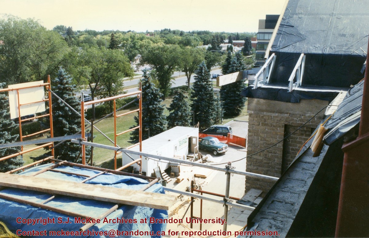
View is southeast from the roof of Clark Hall. Photograph shows some of the scaffolding and materials, as well as the construction trailer (Bird Construction) located on the driveway during the restoration of Clark Hall and the Brandon College Building.
Subject Access
campus photographs
campus construction
Images
Show Less

Brandon University campus construction

http://archives.brandonu.ca/en/permalink/descriptions8008
Part Of
Brandon University Photograph collection
Description Level
Item
GMD
graphic
Date Range
c. 1996
Part Of
Brandon University Photograph collection
Description Level
Item
Series Number
2.1
Item Number
BUPC 2.1.74
GMD
graphic
Date Range
c. 1996
Physical Description
6" x 4" (colour)
Scope and Content
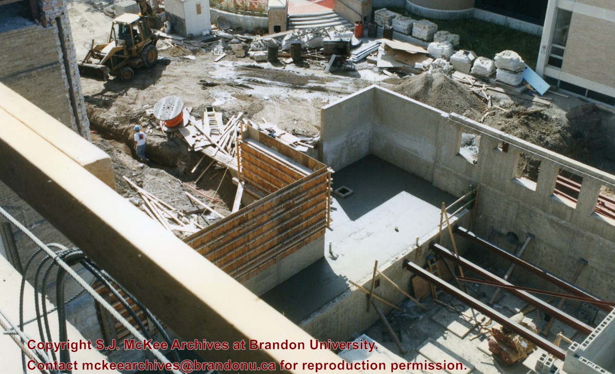
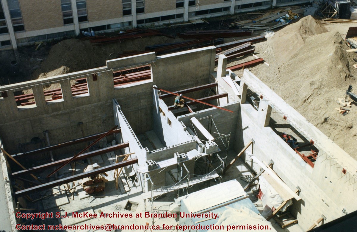
View is southwest from Clark Hall. Photograph shows the construction of the foundation of the extension of Clark Hall and various construction materials located in the courtyard.
Subject Access
campus photographs
campus construction
Images
Show Less

Brandon University campus construction

http://archives.brandonu.ca/en/permalink/descriptions8009
Part Of
Brandon University Photograph collection
Description Level
Item
GMD
graphic
Date Range
c. 1996
Part Of
Brandon University Photograph collection
Description Level
Item
Series Number
2.1
Item Number
BUPC 2.1.75
GMD
graphic
Date Range
c. 1996
Physical Description
6" x 4" (colour)
Scope and Content
View is west from Clark Hall. Photograph shows the construction of the foundation of the extension of Clark Hall.
Subject Access
campus photographs
campus construction
Images
Show Less

Brandon University campus construction

http://archives.brandonu.ca/en/permalink/descriptions8013
Part Of
Brandon University Photograph collection
Description Level
Item
GMD
graphic
Date Range
c. 1996
Part Of
Brandon University Photograph collection
Description Level
Item
Series Number
2.1
Item Number
BUPC 2.1.79
GMD
graphic
Date Range
c. 1996
Physical Description
4" x 6" (colour)
Scope and Content
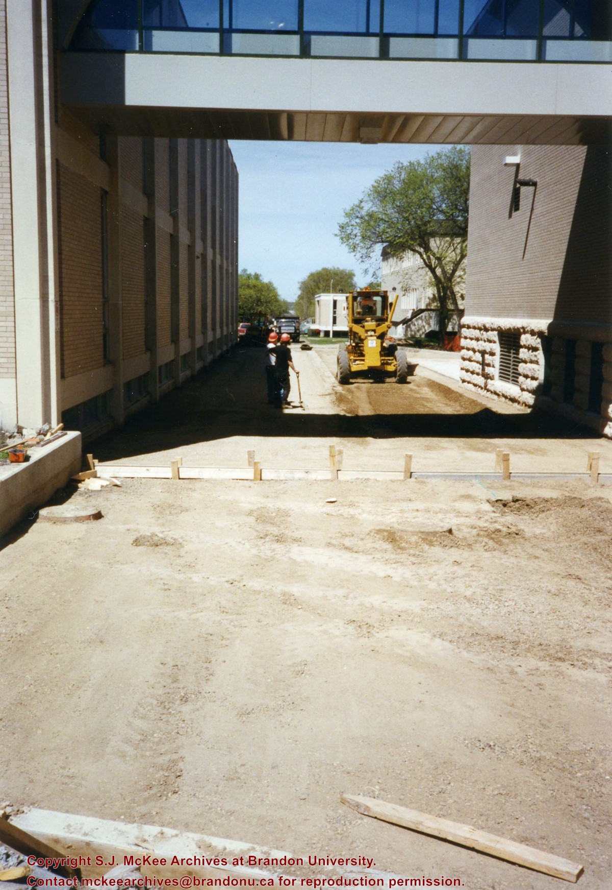
View is north from the courtyard looking underneath the skywalk. Photograph shows the grading of the road between the Clark Hall extension and the A.E. McKenzie Building.
Subject Access
campus photographs
campus construction
Images
Show Less

Brandon University campus construction

http://archives.brandonu.ca/en/permalink/descriptions8015
Part Of
Brandon University Photograph collection
Description Level
Item
GMD
graphic
Date Range
c. 1996
Part Of
Brandon University Photograph collection
Description Level
Item
Series Number
2.1
Item Number
BUPC 2.1.81
GMD
graphic
Date Range
c. 1996
Physical Description
6" x 4" (colour)
Scope and Content
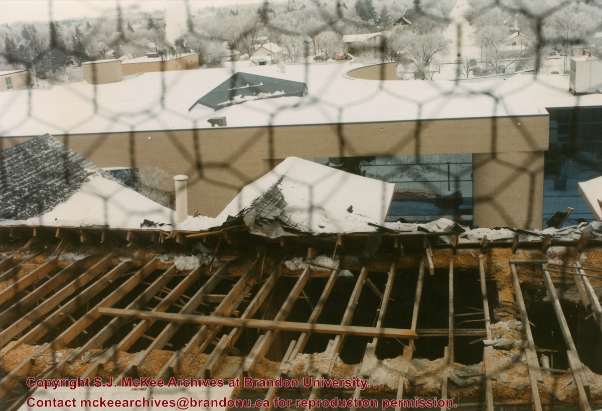
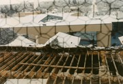
View is west from the roof of the Brandon College Building. Photograph was taken through wire fencing and shows roof beams during construction on the roof of the Brandon College Building during winter. Part of the George T. Richardson Centre and the second steam plant are visible in the background, as well as a few houses.
Subject Access
campus photographs
campus construction
Images
Show Less

Brandon University campus construction

http://archives.brandonu.ca/en/permalink/descriptions8024
Part Of
Brandon University Photograph collection
Description Level
Item
GMD
graphic
Date Range
c. 1996
Part Of
Brandon University Photograph collection
Description Level
Item
Series Number
2.1
Item Number
BUPC 2.1.90
GMD
graphic
Date Range
c. 1996
Physical Description
6" x 4" (colour)
Scope and Content
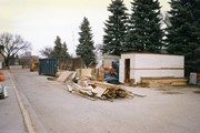
Image is looking north along the driveway in front of Clark Hall and the Brandon College Building, and shows building materials, equipment and debris. The photograph was taken during the renovations of the Brandon College Building and Clark Hall.
Subject Access
campus photographs
campus construction
Images
Show Less

Brandon University campus construction

http://archives.brandonu.ca/en/permalink/descriptions8025
Part Of
Brandon University Photograph collection
Description Level
Item
GMD
graphic
Date Range
c. 1996
Part Of
Brandon University Photograph collection
Description Level
Item
Series Number
2.1
Item Number
BUPC 2.1.91
GMD
graphic
Date Range
c. 1996
Physical Description
4" x 6" (colour)
Scope and Content
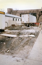
View is west from the sidewalk between the Brandon College Building and the Citzens' Science Building. Photograph shows an H-Hut, two trailers and general construction mayhem.
Subject Access
campus photographs
campus construction
Images
Show Less

Brandon University campus

http://archives.brandonu.ca/en/permalink/descriptions7998
Part Of
Brandon University Photograph collection
Description Level
Item
GMD
graphic
Date Range
c. 1993
Part Of
Brandon University Photograph collection
Description Level
Item
Series Number
2.1
Item Number
BUPC 2.1.64
GMD
graphic
Date Range
c. 1993
Physical Description
6" x 4" (colour)
Scope and Content
Photograph was taken from the roof of the Library and shows the walkway and flower bed on the southeast corner of the George T. Richardson Centre. The Physical Plant H-Hut is visible in the top right hand corner.
Subject Access
campus photographs
Images
Show Less

Aerial view: Brandon College Building

http://archives.brandonu.ca/en/permalink/descriptions606
Part Of
Aerial views and campus photographs
Description Level
Item
GMD
graphic
Date Range
c. 1988
Part Of
Aerial views and campus photographs
Description Level
Item
Series Number
2.1
Item Number
2.1.13
GMD
graphic
Date Range
c. 1988
Physical Description
3.5" x 5" (colour)
Scope and Content
View is north northeast. Photograph shows the Brandon College Building in the foreground with the Education Building and North Hill in the background. Photo was taken from the roof of McMaster Hall.
Images
Show Less

Aerial view: Brandon College campus

http://archives.brandonu.ca/en/permalink/descriptions622
Part Of
Aerial views and campus photographs
Description Level
Item
GMD
graphic
Date Range
c. 1962
Part Of
Aerial views and campus photographs
Description Level
Item
Series Number
2.1
Item Number
2.1.20
GMD
graphic
Date Range
c. 1962
Physical Description
10" x 8" (b/w)
Scope and Content
View is northwest from approximately the corner of 18th Street and Louise Avenue. Photograph shows the Brandon College campus after the completion of Flora Cowan Hall.
Notes
BUPC 2.1.24 is a smaller version of this photograph.
Images
Show Less

Aerial view: Brandon College campus

http://archives.brandonu.ca/en/permalink/descriptions8052
Part Of
Aerial views and campus photographs
Description Level
Item
GMD
graphic
Date Range
c. 1963
Part Of
Aerial views and campus photographs
Description Level
Item
Series Number
2.1
Item Number
2.1.121
GMD
graphic
Date Range
c. 1963
Physical Description
10" x 8" (b/w)
Scope and Content
View is southwest from the northeast corner of the Brandon College campus. Flora Cowan Hall is under construction.
Images
Show Less

Aerial view: Brandon College campus

http://archives.brandonu.ca/en/permalink/descriptions8055
Part Of
Aerial views and campus photographs
Description Level
Item
GMD
graphic
Date Range
c. 1963
Part Of
Aerial views and campus photographs
Description Level
Item
Series Number
2.1
Item Number
2.1.124
GMD
graphic
Date Range
c. 1963
Physical Description
8" x 10" (b/w)
Physical Condition
A problem during development has obscured a portion of Kinsmen Stadium and the southeast corner of the campus.
Scope and Content
View is north from Victoria Avenue between 18th and 20th Streets to the railway tracks. Photograph shows Kinsmen Stadium, the College campus and a number of residential blocks.
Images
Show Less

Aerial view: Brandon College campus

http://archives.brandonu.ca/en/permalink/descriptions8056
Part Of
Aerial views and campus photographs
Description Level
Item
GMD
graphic
Date Range
c. 1963
Part Of
Aerial views and campus photographs
Description Level
Item
Series Number
2.1
Item Number
2.1.125
GMD
graphic
Date Range
c. 1963
Physical Description
10" x 8" (b/w)
Scope and Content
View is northeast from approximately the southwest corner of Victoria Avenue and 22nd Street to the Assiniboine River near 1st Street. Photograph shows the College campus, Kinsmen Stadium, residential blocks, downtown and the railway tracks.
Images
Show Less

Aerial view: Brandon College campus

http://archives.brandonu.ca/en/permalink/descriptions8063
Part Of
Aerial views and campus photographs
Description Level
Item
GMD
graphic
Date Range
c. 1963
Part Of
Aerial views and campus photographs
Description Level
Item
Series Number
2.1
Item Number
2.1.132
GMD
graphic
Date Range
c. 1963
Physical Description
10" x 8" (b/w)
Scope and Content
View is northwest from the 400 block of 18th Street to the corner of 23rd Street and Rosser Avenue. Photograph shows the Brandon College campus (Flora Cowan Hall under construction) and residential blocks.
Images
Show Less

McGuinness Medicine Hat residence - aerial

http://archives.brandonu.ca/en/permalink/descriptions14115
Part Of
Fred McGuinness collection
Description Level
Item
GMD
graphic
Date Range
[1960-1965]
Accession Number
1-2015
Part Of
Fred McGuinness collection
Description Level
Item
Series Number
McG 9
Item Number
1-2015.184
Accession Number
1-2015
GMD
graphic
Date Range
[1960-1965]
Physical Description
10" x 8" (b/w)
Scope and Content
Photograph shows the construction of the McGuinness home in a new housing development in Medicine Hat, 492 6th Street Northeast. Aerial view shows that neighbouring blocks have yet to be constructed.
Name Access
Fred McGuinness
Frederick George McGuinness
Medicine Hat
Subject Access
residences
street scenes
residential streets
winter
aerial views
aerial photography
Storage Location
RG 5 photograph storage drawer 2 (hanging photos)
Arrangement
BR #3 Family photos
Images
Show Less

McGuinness Medicine Hat residence - winter aerial

http://archives.brandonu.ca/en/permalink/descriptions14116
Part Of
Fred McGuinness collection
Description Level
Item
GMD
graphic
Date Range
[1960-1965]
Accession Number
1-2015
Part Of
Fred McGuinness collection
Description Level
Item
Series Number
McG 9
Item Number
1-2015.185
Accession Number
1-2015
GMD
graphic
Date Range
[1960-1965]
Physical Description
10" x 8" (b/w)
Scope and Content
Photograph shows the McGuinness home in a new housing development in Medicine Hat, 492 6th Street Northeast. Aerial view shows that neighbouring blocks have yet to be constructed and the backyard to the McGuinness home is completed.
Name Access
Fred McGuinness
Frederick George McGuinness
Medicine Hat
Subject Access
residences
street scenes
residential streets
winter
aerial views
aerial photography
Storage Location
RG 5 photograph storage drawer 2 (hanging photos)
Arrangement
BR #3 Family photos
Images
Show Less

Aerial view: Brandon College looking west

http://archives.brandonu.ca/en/permalink/descriptions595
Part Of
Aerial views and campus photographs
Description Level
Item
GMD
graphic
Date Range
c. spring 1963
Part Of
Aerial views and campus photographs
Description Level
Item
Series Number
2.1
Item Number
2.1.3
GMD
graphic
Date Range
c. spring 1963
Physical Description
10" x 8" (b/w)
Scope and Content
View is west to McDiarmid Drive from approximately 16th Street between Princess and Louise Avenues. Photograph shows: Brandon College, Fleming School, Coronation Park, and West End Community Centre.
Images
Show Less

20 records – page 3 of 1.