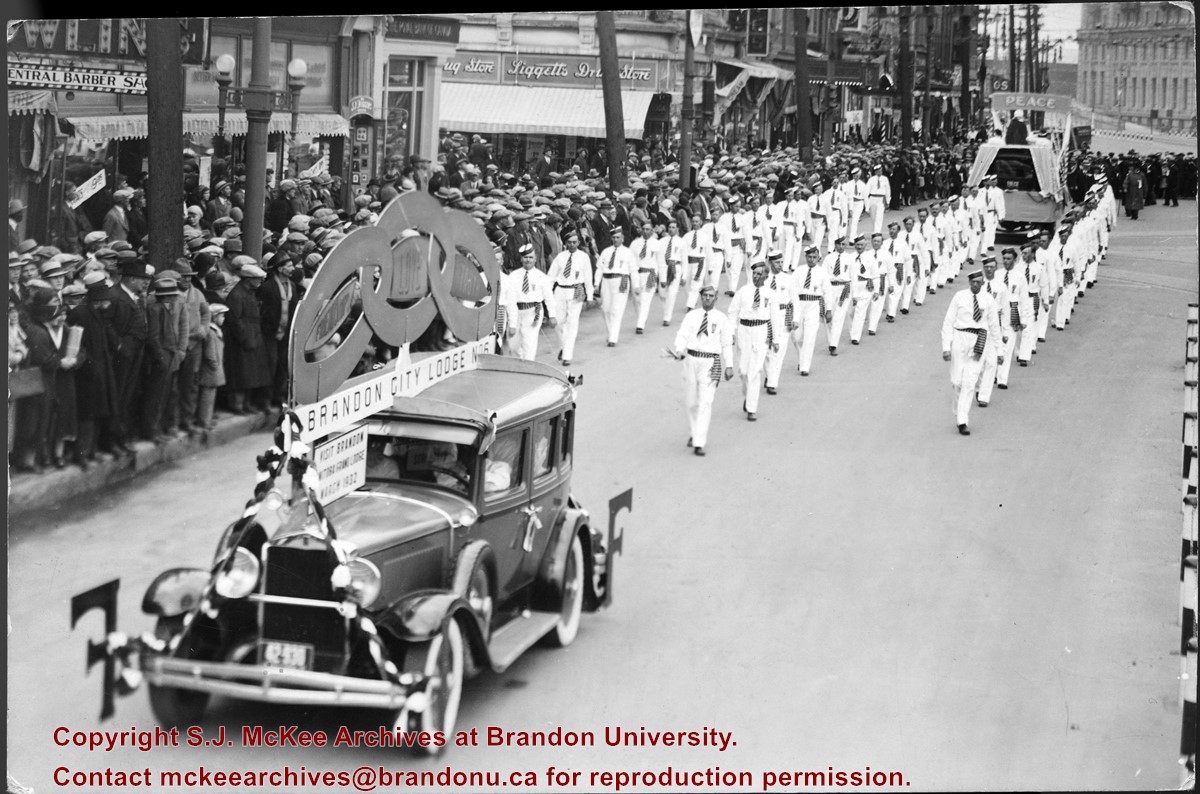
Photograph shows members of the Independent Order of Odd Fellows (IOOF) Brandon City Lodge No.6 parading down a street, possibly Portage Avenue in Winnipeg. Spectators line the street. Visible storefronts include: Central Barber Shop, The Royal Bank of Canada, and Liggetts Drug Store.
Notes
Back of photograph is stamped: The Star Photo Studio, 490 Main Street, Winnipeg, Sep 23, 1931
The Medicine Hat Exhibition and Stampede Parade Day was held on Thursday, July 19, 1962, at 9:30 a.m. The local newspaper reported that approximately 24,000 people were in attendance to see parade marshall Rod Ashburner leading 175 entries consisting of 90 floats, 75 horses, and 10 bands. There were 19 parade categories eligible for $12,000 in prize money and included: junior and senior cowboys and cowgirls; fancy and Shetland ponies; sulky class open; comic, commercial, industrial and organizational floats; decorated cars; special ranch class; 4-H Clubs; and a non-competitive class.
The parade route started at Second St. and Allowance Ave., from Second St. to Ash Ave., north on Ash to First St. SE., from First St. S.E. to Fourth Ave., south to Second St. to South Railway St., south on South Railway St. to Third St., with a finish at McLeod Trail. A route map was published in the Medicine Hat News the day before the parade.
Aerial photographs of the parade were taken by Medicine Hat News photographer Howard Heid (1930-2005) from the private helicopter of John Bourn. Bourn was a pilot from Woodville, Wisconsin, who chartered his four-seater helicopter for sight-seers at exhibitions and stampedes across the county.
(Sources: Pat Currie, "Let 'Er Go!," Medicine Hat News, 19 July 1962,1; Harald Gunderson, "'Eye in the Sky' Best Parade View," Medicine Hat News, 19 July 1962,1; "Parade Starts at 9:30 Sharp," 18 July 1962)
Scope and Content
Photograph shows an aerial view of the Medicine Hat Exhibition and Stampede Parade route with a focus on the First Street SE. A number of gas stations and garages are visible along this route and include Texaco, Shell, Ford, and B/A. The Fraternal Order of Eagles lodge is also visible.
Notes
This photograph appeared on the front page of The Medicine Hat News (19 July 1962).
The Medicine Hat Exhibition and Stampede Parade Day was held on Thursday, July 19, 1962, at 9:30 a.m. The local newspaper reported that approximately 24,000 people were in attendance to see parade marshall Rod Ashburner leading 175 entries consisting of 90 floats, 75 horses, and 10 bands. There were 19 parade categories eligible for $12,000 in prize money and included: junior and senior cowboys and cowgirls; fancy and Shetland ponies; sulky class open; comic, commercial, industrial and organizational floats; decorated cars; special ranch class; 4-H Clubs; and a non-competitive class.
The parade route started at Second St. and Allowance Ave., from Second St. to Ash Ave., north on Ash to First St. SE., from First St. S.E. to Fourth Ave., south to Second St. to South Railway St., south on South Railway St. to Third St., with a finish at McLeod Trail. A route map was published in the Medicine Hat News the day before the parade.
Aerial photographs of the parade were taken by Medicine Hat News photographer Howard Heid (1930-2005) from the private helicopter of John Bourn. Bourn was a pilot from Woodville, Wisconsin, who chartered his four-seater helicopter for sight-seers at exhibitions and stampedes across the county.
(Sources: Pat Currie, "Let 'Er Go!," Medicine Hat News, 19 July 1962,1; Harald Gunderson, "'Eye in the Sky' Best Parade View," Medicine Hat News, 19 July 1962,1; "Parade Starts at 9:30 Sharp," 18 July 1962)
Scope and Content
Photograph shows an aerial view of the Medicine Hat Exhibition and Stampede Parade route with a focus on the First Street SE and and the South Railway Street merge. A number of gas stations and garages are visible along this route and include Texaco, Shell, Ford, and B/A. The Fraternal Order of Eagles lodge is also visible.
Notes
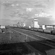
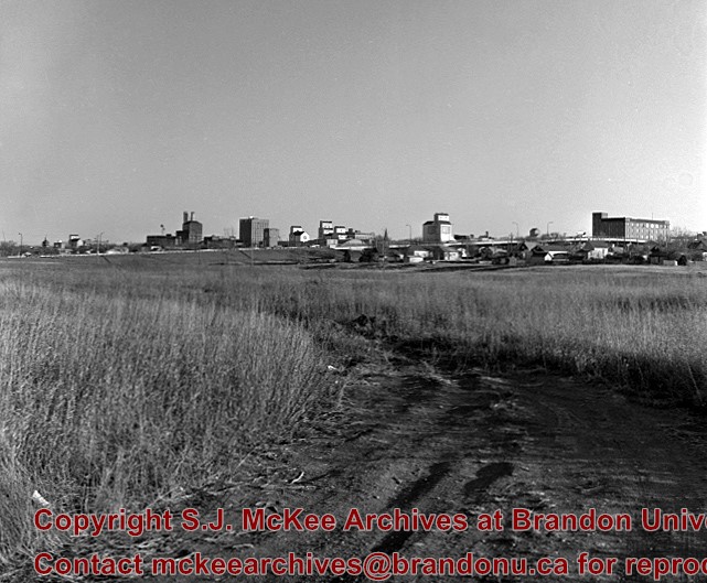
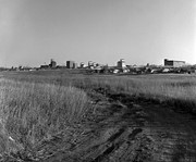
This photograph shows the neighbourhood before rezoning and commercial development.
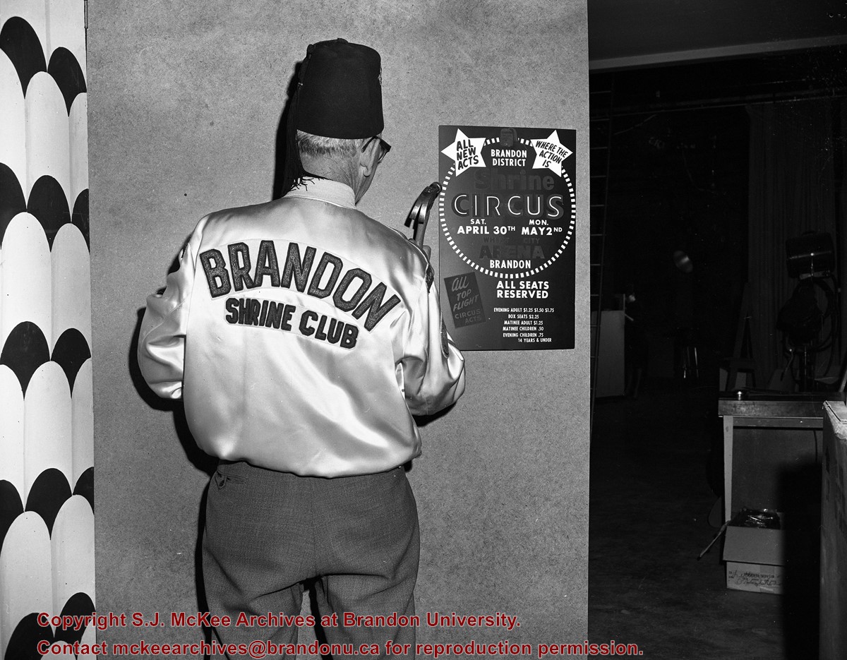
Contract for producing and framing 100 historical photos was awarded to myself as proprietor Clark Smith Studio. This gallery of photos is displayed in Neelin High School. LAS.
Custodial History
For custodial history see the collection level description of the Lawrence Stuckey collection.
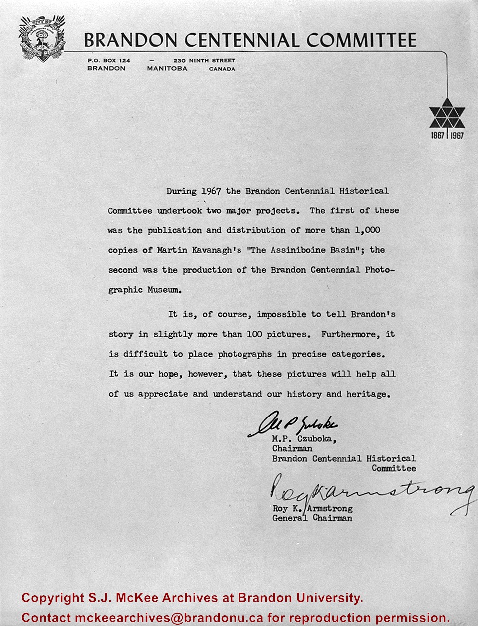
Scope and Content
Letter outlining projects of National Centennial Committee of Brandon.
For custodial history see the collection level description of the Lawrence Stuckey collection.
Scope and Content
Stanley Park from old PC.
Notes
Shows bandstand
[By "PC" Mr. Stuckey likely meant to indicate Park School (built 1904, demolished 1978). Park School was, at the time the photo was taken, located directly across Lorne Avenue from Stanley Park. P.E. 22/07/09]
This wedge-shaped tract of woodland was located west of 34th Street on the south side of the Canadian Pacific Railway. It was formerly owned by the Great Northern Railway, and was acquired by the CPR when the GN line was abandoned in 1936. In 1978 Marathon Realty (CPR) sold this 7 acre property to a developer who planned to build condominiums. However this residential development was objected to for two reasons: [The proposed location] was home to many species of flora & fauna, and it was too close to the CPR mainline. Local residents took out a petition against the development. [Mr. Stuckey] wrote a letter to the editor of the Brandon Sun, [expressing the] attitudes of CPR officials, and read a statement to the Provincial Planning Board suggesting development be refused and the area become an undeveloped park. These efforts would prove successful - see file on same.
Custodial History
For custodial history see the collection level description of the Lawrence Stuckey collection.
Scope and Content
John Indian's Bush (also known as Bang's Bush)
Notes
Additional historical information provided by the Fred McGuinness collection (20-2009). Stuckey's letter to the editor appears in the July 22, 1978 issue of The Brandon Sun.
This wedge-shaped tract of woodland was located west of 34th Street on the south side of the Canadian Pacific Railway. It was formerly owned by the Great Northern Railway, and was acquired by the CPR when the GN line was abandoned in 1936. In 1978 Marathon Realty (CPR) sold this 7 acre property to a developer who planned to build condominiums. However this residential development was objected to for two reasons: [The proposed location] was home to many species of flora & fauna, and it was too close to the CPR mainline. Local residents took out a petition against the development. [Mr. Stuckey] wrote a letter to the editor of the Brandon Sun, [expressed the] attitudes of CPR officials, and read a statement to the provincial planning board suggesting development be refused and the area become an undeveloped park. These efforts would prove successful - see file on same.
Custodial History
For custodial history see the collection level description of the Lawrence Stuckey collection.
Scope and Content
John Indian's Bush (also known as Bang's Bush).
Notes
Additional historical information provided by the Fred McGuinness collection (20-2009). Stuckey's letter to the editor appears in the July 22, 1978 issue of The Brandon Sun.
The Snye was a former channel (oxbow lake) of the Assiniboine River. It was located south of the Assiniboine between about 14th and 24th Streets, and during high water in the spring it carried overflow. For many years it was used as a log storage area for Hanbury's Mill. I remember there being bridges over it at 18th & 22nd Streets. It was dammed with a one way flipper valve at 14th Street that allowed water to flow out to the river, but prevented river water backing into it. Water within the Snye became stagnant in summer and formed a breeding area for mosquitoes. It was deemed a health hazard and the river was gradually filled in. LAS.
Custodial History
For custodial history see the collection level description of the Lawrence Stuckey collection.
Scope and Content
Snye River
Notes
[This negative was produced using a previous published image. P.E. 22/07/09]
Additional historical information provided by the Fred McGuinness collection (20-2009).
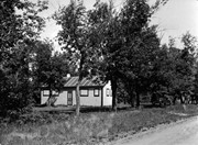
Due to the increasing volume of long-distance auto traffic in the 1920's, the city designated the block between Hill & Queen's Avenues and 9th & 10th streets as a "Tourist Camp" with a few basic facilities. LAS.
Custodial History
For custodial history see the collection level description of the Lawrence Stuckey collection.
Scope and Content
First Tourist Camp
Notes
Courtesy of the Brandon Sun
[Mr. Stuckey put two negatives in the same envelope, numbered N4 and N4a. We have separated them.]


.jpg?width=1200&404=no-img.jpg&watermark=wmk)
.jpg?width=180&404=no-img.jpg)
.jpg?width=1200&404=no-img.jpg&watermark=wmk)
.jpg?width=180&404=no-img.jpg)


.jpg?width=1200&404=no-img.jpg&watermark=wmk)
.jpg?width=180&404=no-img.jpg)
.jpg?width=1200&404=no-img.jpg&watermark=wmk)
.jpg?width=180&404=no-img.jpg)
.jpg?width=1200&404=no-img.jpg&watermark=wmk)
.jpg?width=180&404=no-img.jpg)
.jpg?width=1200&404=no-img.jpg&watermark=wmk)
.jpg?width=180&404=no-img.jpg)
.jpg?width=1200&404=no-img.jpg&watermark=wmk)
.jpg?width=180&404=no-img.jpg)
.jpg%3fmaxheight%3d1000%26maxwidth%3d1000%26watermark%3dwmk&description=John+Indian%27s+Bush)
.jpg%3fmaxheight%3d1000%26maxwidth%3d1000%26watermark%3dwmk&description=John+Indian%27s+Bush)
.jpg%3fmaxheight%3d1000%26maxwidth%3d1000%26watermark%3dwmk&description=Garbage+Pickup+Machine+-+Bins)
.jpg%3fmaxheight%3d1000%26maxwidth%3d1000%26watermark%3dwmk&description=Garbage+Pickup+Machine+-+Operating)
.jpg%3fmaxheight%3d1000%26maxwidth%3d1000%26watermark%3dwmk&description=Garbage+Pickup+Machine+-+Operating)
.jpg%3fmaxheight%3d1000%26maxwidth%3d1000%26watermark%3dwmk&description=Airport+Terminal)
.jpg%3fmaxheight%3d1000%26maxwidth%3d1000%26watermark%3dwmk&description=Airport+Terminal)