Skip header and navigation

Revise Search

20 records – page 1 of 1.

Archibald E. Wilson fonds

http://archives.brandonu.ca/en/permalink/descriptions4809
Part Of
Archibald E. Wilson fonds
Description Level
Fonds
GMD
textual records
Date Range
1895-1932; 1971
Accession Number
18-2000
Other Title Info
RG 5 Western Manitoba Manuscript Collection
Part Of
Archibald E. Wilson fonds
Description Level
Fonds
Accession Number
18-2000
GMD
textual records
Date Range
1895-1932; 1971
Physical Description
2 cm
History / Biographical
Archibald E. Wilson was the son of Reverend E.F. Wilson and the husband of St. Clair Vidal Wilson. Rev. E.F. Wilson was at one time in charge of the Shingwauk and Wawanosh Homes at Sault Ste. Marie. Rev. E.F. Wilson moved to Elkhorn, Manitoba in 1888, to establish an educational home for Indian children. He was joined by his son, Archibald E. Wilson who was, in 1890, appointed assistant to the superintendent. A.E. Wilson became Principal of the Indian Industrial School in 1892. His wife served as Matron of the girls departments. Togerher they had three daughters: E.F. Metita, Winifred St. Clair and Murial Grace, as well as two sons: Edward Vidal, and St. Clair Vidal Wilson. Archibald Wilson and his family lived in Elkhorn, Manitoba during the years 1892 to 1918 while he was principal. At the beginning of his term as Principal there were 12 students enrolled; enrollment reached as high as 95 students, representing eight different nations. In February of 1918, the government withdrew funding and the school closed. In September of 1918, Wilson left Elkhorn to take up his new position as a clerk at an Indian Reserve near Gleichen, Alberta. During its years of operation, the Elkhorn Industrial School included an Athletic department, a curling team and a boys' football team. Students studied carpentry, shoemaking, harness making, tailoring, knitting and sewing. In 1893, the school was presented with a large Canadian flag for being the best Industrial School in Manitoba and the Territories. In November of 1893, a brass band was established, which provided music for the local Anglican Chruch. After a fire demolished most of the school in 1895, Wilson convinced the Federal Department of Indian Affairs to rebuild the school. In 1899, the Elkhorn Industrial School was reopened.
Custodial History
Most of this fonds was at one time in the possession of Principal A.E. Wilson. After Wilson passed away the pieces of the fonds were kept by one of his daughters, Winifred St. Clair Wilson, now deceased. Winifred married Mr. Frank Clark, M.D. and kept the fonds when she moved to Vancouver B.C. and then to Calgary, Alberta. Winifred Clark eventually donated the fonds to the McKee Archives.
Scope and Content
Fonds includes four journals, one testimonial and one newspaper article. The journals include: the ‘7th Annual Report of the Washakada Indian Homet 1895-1896,' written by Principal A.E. Wilson; ‘The Greater Britain Messenger’ September and October 1899, which includes the article ‘The Elkhorn Home, Manitoba;’ ‘The National Monthly of Canada’ September 1902, which includes the article ‘Indian Children at Home;’ and the Centeneray Number (March-April 1932) issue of ‘The Algoma Missionary News,’ which includes an article giving information about Rev. E.F. Wilson and his missionary work. Fonds also includes an article from the November 19, 1971 edition of The Vancouver Sun, entitled "Leisure's Book Reviews," which discusses Indigenous publications in Canada. The testimonial that is included in the fonds, was given to Archibald Wilson upon his departure from Elkhorn. There are 28 subscribers to the testimonial and it is dated September 19, 1918.
Notes
The Wilsons are discussed in J.R. Miller's "Skyscrapers Hide the Heavens: A History of Indian-White Relations in Canada," Miller's "Shingwauk's vision :a history of native residential schools" and John S. Milloy's "A National Crime: The Canadian Government and the Residential School System 1879-1986." Description by Christy Henry.
Storage Location
2000 accessions
Show Less

Doreen Rouse Pachel, Yorkton

http://archives.brandonu.ca/en/permalink/descriptions14241
Part Of
Joseph H. Hughes collection
Description Level
Item
GMD
graphic
Date Range
c.1950
Accession Number
3-1997
Part Of
Joseph H. Hughes collection
Description Level
Item
Series Number
3-1997.1
Item Number
3-1997.1.50
Accession Number
3-1997
Other Numbers
Hughes #52
GMD
graphic
Date Range
c.1950
Physical Description
3.5" x 2.5" (b/w)
Physical Condition
Writing on front of photograph
Scope and Content
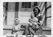
Photograph shows a young woman sitting on a porch step holding a baby. A toddler sits on the step to her right.
Notes
Writing on the front of photograph reads: Doreen Rouse Pachel, Yorkton. Writing on the back of photograph reads: Doreen Rouse Pachel with (Billy & Murray)
Name Access
Doreen Rouse Pachel
Subject Access
family portraits
children
women
Storage Location
RG 5 photograph storage drawer
Images
Show Less

Brandon University campus construction

http://archives.brandonu.ca/en/permalink/descriptions8016
Part Of
Brandon University Photograph collection
Description Level
Item
GMD
graphic
Date Range
c. 1996
Part Of
Brandon University Photograph collection
Creator
Photographer: Sandy Black
Description Level
Item
Series Number
2.1
Item Number
BUPC 2.1.82
GMD
graphic
Date Range
c. 1996
Physical Description
4" x 6" (colour)
Scope and Content
View is northeast from the Brandon College Building. Photograph shows the inside of the Brandon College Building after it had been gutted and then partially rebuilt. The exterior fascade of the west side of the building can be clearly seen in this photograph. A number of houses on the east side of 200 block of 18th Street are also visible, as is the stone fence on Princess Avenue and the flag pole on the front lawn.
Subject Access
campus photographs
campus construction
Brandon streets
Images
Show Less

Aerial view: Brandon College

http://archives.brandonu.ca/en/permalink/descriptions594
Part Of
Brandon University Photograph collection
Description Level
Item
GMD
graphic
Date Range
[fall 1964?]
Part Of
Brandon University Photograph collection
Description Level
Item
Series Number
2.1
Item Number
BUPC 2.1.2
GMD
graphic
Date Range
[fall 1964?]
Physical Description
5" x 4" (b/w)
Scope and Content
Brandon College looking south from 19th Street. Photograph was taken after Flora Cowan Hall was built but before construction of the Education Building.
Subject Access
aerial photographs
campus photographs
campus buildings
Brandon streets
Images
Show Less

Brandon University campus construction

http://archives.brandonu.ca/en/permalink/descriptions8005
Part Of
Brandon University Photograph collection
Description Level
Item
GMD
graphic
Date Range
c. 1996
Part Of
Brandon University Photograph collection
Creator
Photographer: Sandy Black
Description Level
Item
Series Number
2.1
Item Number
BUPC 2.1.71
GMD
graphic
Date Range
c. 1996
Physical Description
4" x 6" (colour)
Scope and Content
View is northeast probably from the roof of McMaster Hall. Photograph shows the construction of the new roof on Clark Hall and the Brandon College Building. A portion of the east side of the 000 and 100 blocks of 18th Street, as well as the corner of 18th Street and Rosser Avenue are visible in the upper left hand corner. This includes the "Downtown Brandon" sign.
Subject Access
campus photographs
campus buildings
campus construction
Brandon streets
Images
Show Less

Brandon University campus construction

http://archives.brandonu.ca/en/permalink/descriptions8006
Part Of
Brandon University Photograph collection
Description Level
Item
GMD
graphic
Date Range
c. 1996
Part Of
Brandon University Photograph collection
Creator
Photographer: Sandy Black
Description Level
Item
Series Number
2.1
Item Number
BUPC 2.1.72
GMD
graphic
Date Range
c. 1996
Physical Description
6" x 4" (colour)
Scope and Content
View is north northeast probably from the roof of McMaster Hall. Photograph shows the construction of the new roof on Clark Hall and the Brandon College Building, as well as the construction of the extension to Clark Hall and the skywalk. Portions of the city as far north as the Assiniboine River are also visible.
Subject Access
campus photographs
campus buildings
campus construction
Brandon streets
Images
Show Less

Brandon University campus construction

http://archives.brandonu.ca/en/permalink/descriptions8018
Part Of
Brandon University Photograph collection
Description Level
Item
GMD
graphic
Date Range
c. 1996
Part Of
Brandon University Photograph collection
Description Level
Item
Series Number
2.1
Item Number
BUPC 2.1.84
GMD
graphic
Date Range
c. 1996
Physical Description
6" x 4" (colour)
Scope and Content
View is north northeast from the roof of McMaster Hall. Photograph shows the campus under construction during the renovation of the Brandon College Building and Clark Hall. The photograph was taken in late fall after the roof had been removed from the buildings but before the construction of the extension of Clark Hall. Construction materials litter the courtyard and driveway. The view looking north extends to The North Hill - a number of residential blocks, particularly to the northeast of 18th Street are visible. Buildings include the International Harvester Building and Kin Village.
Subject Access
campus photographs
campus buildings
campus construction
Brandon streets
Images
Show Less

Brandon University campus construction

http://archives.brandonu.ca/en/permalink/descriptions8020
Part Of
Brandon University Photograph collection
Description Level
Item
GMD
graphic
Date Range
c. 1996
Part Of
Brandon University Photograph collection
Creator
Photographer: Sandy Black
Description Level
Item
Series Number
2.1
Item Number
BUPC 2.1.86
GMD
graphic
Date Range
c. 1996
Physical Description
6" x 4" (colour)
Scope and Content
View is north northeast probably from the roof of McMaster Hall. Photograph shows the construction of the new roof on Clark Hall and the Brandon College Building, as well as the construction of the extension to Clark Hall and the skywalk. The view looking north extends to The North Hill - a number of residential blocks, particularly to the northeast of 18th Street are visible. Buildings include the International Harvester Building and Kin Village.
Subject Access
campus photographs
campus buildings
campus construction
Brandon streets
Images
Show Less

Strand Theatre, Brandon, Manitoba

http://archives.brandonu.ca/en/permalink/descriptions8378
Part Of
Joseph H. Hughes collection
Description Level
Item
GMD
graphic
Date Range
1959
Accession Number
3-1997
Part Of
Joseph H. Hughes collection
Description Level
Item
Series Number
3-1997.1
Item Number
3-1997.1.7
Accession Number
3-1997
GMD
graphic
Date Range
1959
Physical Description
8" x 10" (b/w)
Physical Condition
good
Scope and Content
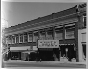
Photograph shows the east side of 10th Street, Brandon, Manitoba. The Strand Theatre marquee shows "Gidget" starring Sandra Dee and Cliff Robertson. Other businesses in the Strand Block include: Ted Heming Jewellers, Waddell's, and Metropolitan Life.
Notes
Photograph dated from "Gidget," the movie playing at the Strand Theatre
Name Access
Strand Theatre
Ted Heming Jewellers
Waddell's
Metropolitan Life
Subject Access
street scenes
Brandon business buildings & facilities after 1940
Storage Location
RG 5 photograph storage drawer
Images
Show Less

Aerial view - Brandon University campus

http://archives.brandonu.ca/en/permalink/descriptions7989
Part Of
Brandon University Photograph collection
Description Level
Item
GMD
graphic
Date Range
c. 2000
Part Of
Brandon University Photograph collection
Creator
Photograph commissioned by Brandon University and taken by Yourview Aerial Scenics Ltd.
Description Level
Item
Series Number
2.1
Item Number
BUPC 2.1.55
GMD
graphic
Date Range
c. 2000
Physical Description
6" x 4" (colour)
Scope and Content
View is southwest from approximatley 16th Street between Princess and Rosser Avenues. Photograph shows the Brandon University campus, as well as surrounding residential blocks, including Flemming, J.R. Reid and Vincent Massey schools.
Subject Access
aerial photographs
campus photographs
campus buildings
Brandon streets
Images
Show Less

Aerial view - Brandon University campus

http://archives.brandonu.ca/en/permalink/descriptions7990
Part Of
Brandon University Photograph collection
Description Level
Item
GMD
graphic
Date Range
c. 2000
Part Of
Brandon University Photograph collection
Creator
Photograph commissioned by Brandon University and taken by Yourview Aerial Scenics Ltd.
Description Level
Item
Series Number
2.1
Item Number
BUPC 2.1.56
GMD
graphic
Date Range
c. 2000
Physical Description
6" x 4" (colour)
Scope and Content
View is west southwest from approximatley 16th Street between Princess and Lorne Avenues. Photograph shows the Brandon University campus, as well as surrounding residential blocks between 16th and 23rd Streets, Princess and Louise Avenues..
Subject Access
aerial photographs
campus photographs
campus buildings
Brandon streets
Images
Show Less

Aerial view - Brandon University campus

http://archives.brandonu.ca/en/permalink/descriptions7991
Part Of
Brandon University Photograph collection
Description Level
Item
GMD
graphic
Date Range
c. 2000
Part Of
Brandon University Photograph collection
Creator
Photograph commissioned by Brandon University and taken by Yourview Aerial Scenics Ltd.
Description Level
Item
Series Number
2.1
Item Number
BUPC 2.1.57
GMD
graphic
Date Range
c. 2000
Physical Description
6" x 4" (colour)
Scope and Content
View is west from approximatley 17th Street between Lorne and Louise Avenues. Photograph shows a portion of the Brandon University campus (excluding the Education Building and anything north of it), as well as surrounding residential blocks from approximatley 17th Street to 22nd Street.
Subject Access
aerial photographs
campus photographs
campus buildings
Brandon streets
Images
Show Less

Aerial view - Brandon University campus

http://archives.brandonu.ca/en/permalink/descriptions7992
Part Of
Brandon University Photograph collection
Description Level
Item
GMD
graphic
Date Range
c. 1990
Part Of
Brandon University Photograph collection
Description Level
Item
Series Number
2.1
Item Number
BUPC 2.1.58
GMD
graphic
Date Range
c. 1990
Physical Description
5" x 3.5" (colour)
Scope and Content
View is west northwest from approximatley 16th Street and Louise Avenue. Photograph shows the Brandon University campus, prior to the Library Extension, and a large portion of the city to the west of the campus.
Subject Access
aerial photographs
campus photographs
campus buildings
Brandon streets
Images
Show Less

Aerial view - Brandon University campus

http://archives.brandonu.ca/en/permalink/descriptions7993
Part Of
Brandon University Photograph collection
Description Level
Item
GMD
graphic
Date Range
c. 1990
Part Of
Brandon University Photograph collection
Description Level
Item
Series Number
2.1
Item Number
BUPC 2.1.59
GMD
graphic
Date Range
c. 1990
Physical Description
5" x 3.5" (colour)
Scope and Content
View is northwest from approximatley 16th Street and Louise Avenue. Photograph shows the Brandon University campus, prior to the Library Extension, and a large portion of the city to the west of the campus.
Subject Access
aerial photographs
campus photographs
campus buildings
Brandon streets
Show Less

Carlton Cafe, Brandon, Manitoba

http://archives.brandonu.ca/en/permalink/descriptions8382
Part Of
Joseph H. Hughes collection
Description Level
Item
GMD
graphic
Date Range
c. 1959
Accession Number
3-1997
Part Of
Joseph H. Hughes collection
Description Level
Item
Series Number
3-1997.1
Item Number
3-1997.1.10
Accession Number
3-1997
GMD
graphic
Date Range
c. 1959
Physical Description
8" x 10" (b/w)
Physical Condition
good
Scope and Content
Photograph of east side of 10th Street, Brandon, Manitoba, between Rosser and Princess Avenues. Visible businesses include: The Bank of Montreal, Barclay's Shoe Store, Carlton Cafe (in the former Cigar Factory), and Ted Heming Jewellers. The McKenzie Seed building is visible in the background.
Name Access
Bank of Montreal
Barclay's Shoe Store
Carlton Cafe
Ted Heming Jewellers
McKenzie Seeds
10th Street
Subject Access
downtowns
street scenes
Brandon business buildings & facilities after 1940
building exteriors
Storage Location
RG 5 photograph storage drawer
Images
Show Less

The Brown Block, Brandon, Manitoba

http://archives.brandonu.ca/en/permalink/descriptions8383
Part Of
Joseph H. Hughes collection
Description Level
Item
GMD
graphic
Date Range
c. 1959
Accession Number
3-1997
Part Of
Joseph H. Hughes collection
Description Level
Item
Series Number
3-1997.1
Item Number
3-1997.1.11
Accession Number
3-1997
GMD
graphic
Date Range
c. 1959
Physical Description
8 " x 10" (b/w)
Physical Condition
good
Scope and Content
Photograph shows the east side of 10th Street, Brandon, Manitoba, between Rosser and Princess Avenues. Businesses visible in the Brown Block include (from north to south): Singer, Pittsburgh Paint & Glass, O. Stark & Son, Elna Sewing Centre, and Canadian Pacific Telegraphs. The Prince Edward Hotel is visible in the background.
Name Access
Brown Block
Singer
Pittsburgh Paint & Glass
O. Stark & Son
Elna Sewing Centre
Canadian Pacific Telegraphs
Prince Edward Hotel
10th Street
Subject Access
downtowns
street scenes
Brandon business buildings & facilities after 1940
building exteriors
Storage Location
RG 5 photograph storage drawer
Images
Show Less

Strathcona Block, Brandon, Manitoba

http://archives.brandonu.ca/en/permalink/descriptions8410
Part Of
Joseph H. Hughes collection
Description Level
Item
GMD
graphic
Date Range
c.1950
Accession Number
3-1997
Part Of
Joseph H. Hughes collection
Creator
Photographer: R.M. Coleman
Description Level
Item
Series Number
3-1997.1
Item Number
3-1997.1.32
Accession Number
3-1997
GMD
graphic
Date Range
c.1950
Physical Description
5" x 7" (b/w)
Physical Condition
good
Scope and Content
Photograph shows the Strathcona Block on the west side of 10th Street in the 100-block. Simpsons-Sears and Lionel Electric are the ground floor shops.
Name Access
Strathcona Block
Simpsons-Sears Ltd.
Lionel Electric
Subject Access
downtowns
street scenes
Brandon business buildings & facilities after 1940
building exteriors
Storage Location
RG 5 photograph storage drawer
Images
Show Less

Hughes Building, Brandon, Manitoba

http://archives.brandonu.ca/en/permalink/descriptions8403
Part Of
Joseph H. Hughes collection
Description Level
Item
GMD
graphic
Date Range
c. 1955
Accession Number
3-1997
Part Of
Joseph H. Hughes collection
Description Level
Item
Series Number
3-1997.1
Item Number
3-1997.1.25
Accession Number
3-1997
GMD
graphic
Date Range
c. 1955
Physical Description
4.5" x 6.75" (b/w)
Physical Condition
good
Scope and Content
Photograph shows the northwest corner of 10th Street and Princess Avenue. Traffic on the west side of Princess Avenue appears to travelling both ways. A taxi waits at the intersection. Above the west entrance on the corner building is an electric sign that spells "Hughes Bldg." A second storey has been added to the portion of the Doig's shop that is adjacent to the Alexandra Block.
Notes
A negative accompanies the photograph.
Name Access
Doig's
Hughes Building
Alexandra Block
Princess Avenue
10th Street
Subject Access
downtowns
street scenes
Brandon business buildings & facilities after 1940
building exteriors
taxi
Storage Location
RG 5 photograph storage drawer
Images
Show Less

Aerial view - Brandon College looking southwest

http://archives.brandonu.ca/en/permalink/descriptions601
Part Of
Brandon University Photograph collection
Description Level
Item
GMD
graphic
Date Range
[1963-1966]
Part Of
Brandon University Photograph collection
Description Level
Item
Series Number
2.1
Item Number
BUPC 2.1.8
GMD
graphic
Date Range
[1963-1966]
Physical Description
5" x 4" (b/w)
Scope and Content
Image shows the Brandon College campus from 17th Street looking southwest. The photo was taken after the completion of the original Music Building in 1963, but construction of the Education Building. Also visible are a number of properties on the 200 block of 18th Street and the 200 block of 20th Street.
Subject Access
aerial photographs
campus photographs
campus buildings
Brandon streets
Images
Show Less

Ted Heming Jewellers, Brandon, Manitoba

http://archives.brandonu.ca/en/permalink/descriptions8379
Part Of
Joseph H. Hughes collection
Description Level
Item
GMD
graphic
Date Range
1959
Accession Number
3-1997
Part Of
Joseph H. Hughes collection
Description Level
Item
Series Number
3-1997.1
Item Number
3-1997.1.8
Accession Number
3-1997
GMD
graphic
Date Range
1959
Physical Description
8" x 10" (b/w)
Physical Condition
good
Scope and Content
Photograph shows Ted Heming Jewellers on the east side of 10th Street, Brandon, Manitoba, with the Strand Theatre to the south of the building complex. Other visible businesses in the Strand Block include: Hughes & Co. Ltd., Smart's Stationery, Waddell's, and Metropolitan Life.
Notes
Photograph dated from "Gidget," the movie playing at the Strand Theatre
Name Access
Ted Heming Jewellers
Hughes & Co.
Smart's Stationery
Waddell's
Strand Theatre
Metropolitan Life
10th Street
Subject Access
downtowns
street scenes
Brandon business buildings & facilities after 1940
building exteriors
Storage Location
RG 5 photograph storage drawer
Images
Show Less

20 records – page 1 of 1.