Skip header and navigation

Revise Search

20 records – page 1 of 1.

Aerial view - Brandon University campus

http://archives.brandonu.ca/en/permalink/descriptions7989
Part Of
Brandon University Photograph collection
Description Level
Item
GMD
graphic
Date Range
c. 2000
Part Of
Brandon University Photograph collection
Creator
Photograph commissioned by Brandon University and taken by Yourview Aerial Scenics Ltd.
Description Level
Item
Series Number
2.1
Item Number
BUPC 2.1.55
GMD
graphic
Date Range
c. 2000
Physical Description
6" x 4" (colour)
Scope and Content
View is southwest from approximatley 16th Street between Princess and Rosser Avenues. Photograph shows the Brandon University campus, as well as surrounding residential blocks, including Flemming, J.R. Reid and Vincent Massey schools.
Subject Access
aerial photographs
campus photographs
campus buildings
Brandon streets
Images
Show Less

Aerial view - Brandon University campus

http://archives.brandonu.ca/en/permalink/descriptions7990
Part Of
Brandon University Photograph collection
Description Level
Item
GMD
graphic
Date Range
c. 2000
Part Of
Brandon University Photograph collection
Creator
Photograph commissioned by Brandon University and taken by Yourview Aerial Scenics Ltd.
Description Level
Item
Series Number
2.1
Item Number
BUPC 2.1.56
GMD
graphic
Date Range
c. 2000
Physical Description
6" x 4" (colour)
Scope and Content
View is west southwest from approximatley 16th Street between Princess and Lorne Avenues. Photograph shows the Brandon University campus, as well as surrounding residential blocks between 16th and 23rd Streets, Princess and Louise Avenues..
Subject Access
aerial photographs
campus photographs
campus buildings
Brandon streets
Images
Show Less

Aerial view - Brandon University campus

http://archives.brandonu.ca/en/permalink/descriptions7991
Part Of
Brandon University Photograph collection
Description Level
Item
GMD
graphic
Date Range
c. 2000
Part Of
Brandon University Photograph collection
Creator
Photograph commissioned by Brandon University and taken by Yourview Aerial Scenics Ltd.
Description Level
Item
Series Number
2.1
Item Number
BUPC 2.1.57
GMD
graphic
Date Range
c. 2000
Physical Description
6" x 4" (colour)
Scope and Content
View is west from approximatley 17th Street between Lorne and Louise Avenues. Photograph shows a portion of the Brandon University campus (excluding the Education Building and anything north of it), as well as surrounding residential blocks from approximatley 17th Street to 22nd Street.
Subject Access
aerial photographs
campus photographs
campus buildings
Brandon streets
Images
Show Less

Aerial view - Brandon University campus

http://archives.brandonu.ca/en/permalink/descriptions7992
Part Of
Brandon University Photograph collection
Description Level
Item
GMD
graphic
Date Range
c. 1990
Part Of
Brandon University Photograph collection
Description Level
Item
Series Number
2.1
Item Number
BUPC 2.1.58
GMD
graphic
Date Range
c. 1990
Physical Description
5" x 3.5" (colour)
Scope and Content
View is west northwest from approximatley 16th Street and Louise Avenue. Photograph shows the Brandon University campus, prior to the Library Extension, and a large portion of the city to the west of the campus.
Subject Access
aerial photographs
campus photographs
campus buildings
Brandon streets
Images
Show Less

Aerial view - Brandon University campus

http://archives.brandonu.ca/en/permalink/descriptions7993
Part Of
Brandon University Photograph collection
Description Level
Item
GMD
graphic
Date Range
c. 1990
Part Of
Brandon University Photograph collection
Description Level
Item
Series Number
2.1
Item Number
BUPC 2.1.59
GMD
graphic
Date Range
c. 1990
Physical Description
5" x 3.5" (colour)
Scope and Content
View is northwest from approximatley 16th Street and Louise Avenue. Photograph shows the Brandon University campus, prior to the Library Extension, and a large portion of the city to the west of the campus.
Subject Access
aerial photographs
campus photographs
campus buildings
Brandon streets
Show Less

Aerial view: Brandon College

http://archives.brandonu.ca/en/permalink/descriptions594
Part Of
Brandon University Photograph collection
Description Level
Item
GMD
graphic
Date Range
[fall 1964?]
Part Of
Brandon University Photograph collection
Description Level
Item
Series Number
2.1
Item Number
BUPC 2.1.2
GMD
graphic
Date Range
[fall 1964?]
Physical Description
5" x 4" (b/w)
Scope and Content
Brandon College looking south from 19th Street. Photograph was taken after Flora Cowan Hall was built but before construction of the Education Building.
Subject Access
aerial photographs
campus photographs
campus buildings
Brandon streets
Images
Show Less

Aerial view - Brandon College looking southwest

http://archives.brandonu.ca/en/permalink/descriptions601
Part Of
Brandon University Photograph collection
Description Level
Item
GMD
graphic
Date Range
[1963-1966]
Part Of
Brandon University Photograph collection
Description Level
Item
Series Number
2.1
Item Number
BUPC 2.1.8
GMD
graphic
Date Range
[1963-1966]
Physical Description
5" x 4" (b/w)
Scope and Content
Image shows the Brandon College campus from 17th Street looking southwest. The photo was taken after the completion of the original Music Building in 1963, but construction of the Education Building. Also visible are a number of properties on the 200 block of 18th Street and the 200 block of 20th Street.
Subject Access
aerial photographs
campus photographs
campus buildings
Brandon streets
Images
Show Less

Cando Contracting Ltd.

http://archives.brandonu.ca/en/permalink/descriptions13920
Part Of
Fred McGuinness collection
Description Level
Item
GMD
graphic
Date Range
c.1990
Accession Number
20-2009
Part Of
Fred McGuinness collection
Description Level
Item
Series Number
McG 9
Item Number
20-2009.230
Accession Number
20-2009
GMD
graphic
Date Range
c.1990
Physical Description
5" x 3.5" (b/w)
History / Biographical
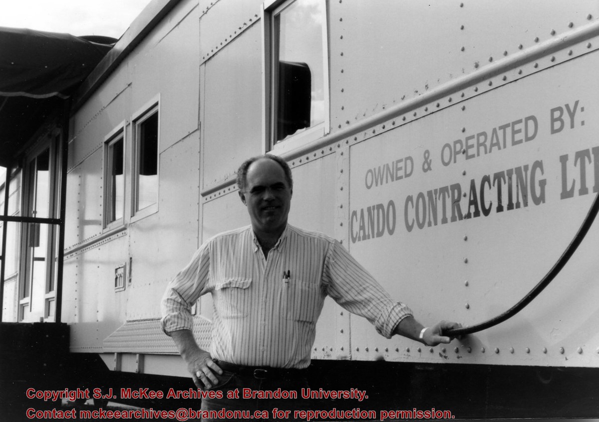
Cando Contracting Ltd. was found in 1978 by Gord Peters and Rick Hammond. The company began as a small rail line dismantling and salvage company operating out of Brandon, Manitoba. The company changed its name in 2013 to Cando Rail Services Ltd., which supplies railway support services (e.g., engineering and track services, industrial rail services, mechanical services, rail car storage, railway material sales, short line operations, transload services) to industry and the rail sector. The company maintains its headquarters in Brandon, Manitoba, and has regional offices located in Calgary, Edmonton, Winnipeg, Whitby, and Adel (Iowa). (Source: www.candoltd.com, accessed 05 Dec 2015)
Scope and Content
Photograph shows Gord Peters standing in front of the rail car that forms the entrance of Cando Contracting Ltd. in Brandon, Manitoba
Notes
Negatives stored with photograph
Name Access
Cando Contracting Ltd
Gord Peters
Subject Access
contractors
Brandon business buildings & facilities after 1940
Brandon Industries
Storage Location
RG 5 photograph storage drawer 2 (hanging photos)
Arrangement
From 20-2009 #4 plastic envelope #2; in Canada Wide Magazines Ltd. envelope post marked 03 November 1990
Images
Show Less
Part Of
Brandon University Photograph collection
Description Level
Item
GMD
graphic
Date Range
c. 1985
Part Of
Brandon University Photograph collection
Description Level
Item
Series Number
2.1
Item Number
BUPC 2.1.60
GMD
graphic
Date Range
c. 1985
Physical Description
5" x 3.5" (colour)
Scope and Content
Photograph shows the removal of one of the houses formerly located on 20th Street between Louise and Princess Avenues. The houses on those blocks were removed to create parking lots for the University. A Fed Zavislak Ltd. Well Drilling & Trucking pickup truck is visible at the curb.
Subject Access
campus photographs
Brandon streets
Images
Show Less
Part Of
Brandon University Photograph collection
Description Level
Item
GMD
graphic
Date Range
c. 1985
Part Of
Brandon University Photograph collection
Description Level
Item
Series Number
2.1
Item Number
BUPC 2.1.61
GMD
graphic
Date Range
c. 1985
Physical Description
5" x 3.5" (colour)
Scope and Content
Photograph shows the removal of one of the houses formerly located on 20th Street between Louise and Princess Avenues. The houses on those blocks were removed to create parking lots for the University.
Subject Access
campus photographs
Brandon streets
Images
Show Less

Aerial view: Brandon College from 23rd Street

http://archives.brandonu.ca/en/permalink/descriptions602
Part Of
Brandon University Photograph collection
Description Level
Item
GMD
graphic
Date Range
[1963-1966]
Part Of
Brandon University Photograph collection
Description Level
Item
Series Number
2.1
Item Number
BUPC 2.1.9
GMD
graphic
Date Range
[1963-1966]
Physical Description
5" x 4" (b/w)
Scope and Content
Image is looking east northeast from approximately the 300 block of 23rd Street between Lorne and Louise Avenues. Photograph shows the Brandon College campus after the opening of the original Music Building in 1963, but before the construction of the Education Building in 1966. A number of house on the 300 blocks of 22nd and 21st Streets are visible in the foreground, with the A.E. McKenzie Seed Co., the Prince Edward Hotel and various grain elevators on the horizon.
Subject Access
aerial photographs
campus photographs
campus buildings
Brandon streets
Grain elevators
Images
Show Less
Part Of
Fred McGuinness collection
Description Level
Item
GMD
graphic
Date Range
[1929-1931]
Accession Number
20-2009
Part Of
Fred McGuinness collection
Creator
Photograph: C.J. Smith
Description Level
Item
Series Number
McG 9
Item Number
20-2009.105
Accession Number
20-2009
GMD
graphic
Date Range
[1929-1931]
Physical Description
9.5" x 7.5" (b/w)
Material Details
On matting
History / Biographical
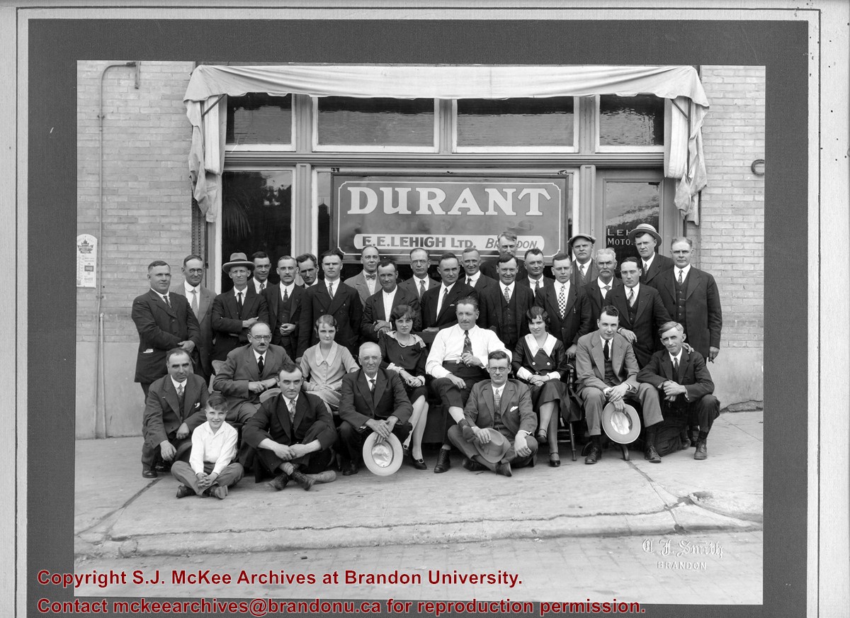
The 1901 Canadian Census places the Lehigh family near Brockville, Ontario, where Everett E. Lehigh (b. 19 May 1881) was farming with his widowed father Solon (b. 20 Aug 1849) and younger sister, Edna (b. 08 Feb 1884). The findagrave.com genealogical website identifies a Mary Wickware as marrying Everett E. Lehigh in Alqonquin, Ontario, on 04 April 1905. E.E. Lehigh appears in the Henderson's Brandon City Directories in 1919. By 1923, he was Vice-President of Motors Ltd., which had its shop on 151-7th Street. By 1925, Lehigh had taken over the garage, renaming it Lehigh Motors, which became the sole agent for McLaughlin Motor Cars. By 1927, Lehigh Motors had opened a second branch on 12th Street and Princess Avenue, which was formerly the Brandon Auto Garage. Lehigh had become the exclusive dealer for McLaughlin-Buick, Pontiac, and Oldsmobile motor cars. It appears Lehigh moved his business, E.E. Lehigh Ltd., to 799 Pacific Avenue by 1929. By then, Lehigh had a head office in Winnipeg at 640 Portage Avenue where he served as president and was the provincial distributor for Rugby trucks and Durant cars. Although E.E. Lehigh had a residence in Brandon (325 - 14th Street), Mr. S.G. Cunningham was listed as the Brandon representative for Lehigh Motors Ltd. in the Henderson Directories. By 1931, E.E. Lehigh Ltd. had moved once again, this time to 151-153 - 9th Street. E.E. Lehigh disappears from the Henderson's Brandon City Directory by 1933 and a Mrs. E.E. Lehigh (possibly Mary (Wickware) Lehigh, d.21 July 1943) is listed under the 14th Street residence. The 9th Street garage address is divided between Munns Taxi (151-9th Street) and Wheat City Auto Wreckers (153-9th Street.)
Custodial History
Photograph was in possession of Mrs. Ruby Miles, who passed the image on to Fred McGuinness. McGuinness makes reference to Mrs. Miles and this photograph in his Sunbeams column (Source: F.A. Rosser, "Another interesting chat with a daughter of the plains," Brandon Sun 18 Aug 1981).
Scope and Content
Photograph shows a group portrait of 33 individuals standing and seated in front of the business E.E. Lehigh Ltd., Brandon. The storefront window has a sign that reads: Durant Motor Cars, E.E. Lehigh Ltd., Brandon. The door to the business has Lehigh Motors stencilled on the window. The men are wearing jackets and ties, and there are three women, possibly clerical staff, wearing 1920s era dresses. The elderly man seated in the centre of the photograph, wearing a long-sleeved white dress shirt might be Everett E. Lehigh.
Notes
Writing on the front of the photograph is embossed: C.J. Smith
Name Access
E.E. Lehigh
Subject Access
garages
Transportation
Brandon business buildings & facilities before 1940
store exteriors
Storage Location
McGuinness oversize storage drawer (1-2015)
Related Material
Ruby Miles collection 14-2003
Images
Show Less

Brandon University campus construction

http://archives.brandonu.ca/en/permalink/descriptions8016
Part Of
Brandon University Photograph collection
Description Level
Item
GMD
graphic
Date Range
c. 1996
Part Of
Brandon University Photograph collection
Creator
Photographer: Sandy Black
Description Level
Item
Series Number
2.1
Item Number
BUPC 2.1.82
GMD
graphic
Date Range
c. 1996
Physical Description
4" x 6" (colour)
Scope and Content
View is northeast from the Brandon College Building. Photograph shows the inside of the Brandon College Building after it had been gutted and then partially rebuilt. The exterior fascade of the west side of the building can be clearly seen in this photograph. A number of houses on the east side of 200 block of 18th Street are also visible, as is the stone fence on Princess Avenue and the flag pole on the front lawn.
Subject Access
campus photographs
campus construction
Brandon streets
Images
Show Less

Brandon University campus construction

http://archives.brandonu.ca/en/permalink/descriptions8005
Part Of
Brandon University Photograph collection
Description Level
Item
GMD
graphic
Date Range
c. 1996
Part Of
Brandon University Photograph collection
Creator
Photographer: Sandy Black
Description Level
Item
Series Number
2.1
Item Number
BUPC 2.1.71
GMD
graphic
Date Range
c. 1996
Physical Description
4" x 6" (colour)
Scope and Content
View is northeast probably from the roof of McMaster Hall. Photograph shows the construction of the new roof on Clark Hall and the Brandon College Building. A portion of the east side of the 000 and 100 blocks of 18th Street, as well as the corner of 18th Street and Rosser Avenue are visible in the upper left hand corner. This includes the "Downtown Brandon" sign.
Subject Access
campus photographs
campus buildings
campus construction
Brandon streets
Images
Show Less

Brandon University campus construction

http://archives.brandonu.ca/en/permalink/descriptions8006
Part Of
Brandon University Photograph collection
Description Level
Item
GMD
graphic
Date Range
c. 1996
Part Of
Brandon University Photograph collection
Creator
Photographer: Sandy Black
Description Level
Item
Series Number
2.1
Item Number
BUPC 2.1.72
GMD
graphic
Date Range
c. 1996
Physical Description
6" x 4" (colour)
Scope and Content
View is north northeast probably from the roof of McMaster Hall. Photograph shows the construction of the new roof on Clark Hall and the Brandon College Building, as well as the construction of the extension to Clark Hall and the skywalk. Portions of the city as far north as the Assiniboine River are also visible.
Subject Access
campus photographs
campus buildings
campus construction
Brandon streets
Images
Show Less

Brandon University campus construction

http://archives.brandonu.ca/en/permalink/descriptions8018
Part Of
Brandon University Photograph collection
Description Level
Item
GMD
graphic
Date Range
c. 1996
Part Of
Brandon University Photograph collection
Description Level
Item
Series Number
2.1
Item Number
BUPC 2.1.84
GMD
graphic
Date Range
c. 1996
Physical Description
6" x 4" (colour)
Scope and Content
View is north northeast from the roof of McMaster Hall. Photograph shows the campus under construction during the renovation of the Brandon College Building and Clark Hall. The photograph was taken in late fall after the roof had been removed from the buildings but before the construction of the extension of Clark Hall. Construction materials litter the courtyard and driveway. The view looking north extends to The North Hill - a number of residential blocks, particularly to the northeast of 18th Street are visible. Buildings include the International Harvester Building and Kin Village.
Subject Access
campus photographs
campus buildings
campus construction
Brandon streets
Images
Show Less

Brandon University campus construction

http://archives.brandonu.ca/en/permalink/descriptions8020
Part Of
Brandon University Photograph collection
Description Level
Item
GMD
graphic
Date Range
c. 1996
Part Of
Brandon University Photograph collection
Creator
Photographer: Sandy Black
Description Level
Item
Series Number
2.1
Item Number
BUPC 2.1.86
GMD
graphic
Date Range
c. 1996
Physical Description
6" x 4" (colour)
Scope and Content
View is north northeast probably from the roof of McMaster Hall. Photograph shows the construction of the new roof on Clark Hall and the Brandon College Building, as well as the construction of the extension to Clark Hall and the skywalk. The view looking north extends to The North Hill - a number of residential blocks, particularly to the northeast of 18th Street are visible. Buildings include the International Harvester Building and Kin Village.
Subject Access
campus photographs
campus buildings
campus construction
Brandon streets
Images
Show Less

Brandon University campus

http://archives.brandonu.ca/en/permalink/descriptions7998
Part Of
Brandon University Photograph collection
Description Level
Item
GMD
graphic
Date Range
c. 1993
Part Of
Brandon University Photograph collection
Description Level
Item
Series Number
2.1
Item Number
BUPC 2.1.64
GMD
graphic
Date Range
c. 1993
Physical Description
6" x 4" (colour)
Scope and Content
Photograph was taken from the roof of the Library and shows the walkway and flower bed on the southeast corner of the George T. Richardson Centre. The Physical Plant H-Hut is visible in the top right hand corner.
Subject Access
campus photographs
Images
Show Less

John R. Brodie Science Centre flower beds

http://archives.brandonu.ca/en/permalink/descriptions3019
Part Of
Brandon University Photograph collection
Description Level
Item
GMD
graphic
Date Range
May 1978
Part Of
Brandon University Photograph collection
Description Level
Item
Series Number
2.1
Item Number
BUPC 2.1.40
GMD
graphic
Date Range
May 1978
Physical Description
5" x 3.5"
Scope and Content
Photograph shows a number of the flower beds located on the north side of the John R. Brodie Science Centre.
Subject Access
campus photographs
Show Less
Part Of
Brandon University Photograph collection
Description Level
Item
GMD
graphic
Date Range
May 1978
Part Of
Brandon University Photograph collection
Description Level
Item
Series Number
2.1
Item Number
BUPC 2.1.41
GMD
graphic
Date Range
May 1978
Physical Description
5" x 3.5" (colour)
Scope and Content
Photograph shows a sign bearing a campus map. The sign was located at the north entrance to the driveway.
Subject Access
campus photographs
Images
Show Less

20 records – page 1 of 1.