For custodial history see the collection level description of the Lawrence Stuckey collection.
Scope and Content
View of the southeast corner of Tenth Street and Princess Avenue, showing the Prince Edward Hotel (left) and an Imperial Oil Building (right).
Notes
The second floor of the Imperial Oil building became the Imperial Dance Garden in 1934. The small wooden post in a concrete foundation in the centre of the intersection was called a "Silent Policeman". You were supposed to keep it on your left while making a left turn. They took quite a beating.
[Information in "Notes" provided by the Fred McGuinness collection (20-2009).]
[The land on which city hall stood in this photo is now known as Princess Park. P.E. 01/06/09]
Custodial History
For custodial history see the collection level description of the Lawrence Stuckey collection.
Scope and Content
Princess Avenue, showing City Hall & CKX radio tower
Notes
[View is from 9th Street looking east. P.E.]
"Radio towers of CKX on city hall grounds were 150 feet tall; Studio and transmitter were on the east side of city hall." - Fred McGuinness collection (20-2009).
Photograph of the northeast corner of 10th Street and Princess Avenue facing northeast. An Imperial Esso Dealer is situated on the southeast corner. On the northeast side the following businesses are visible: Thunderbird Bowl, Canadian Pacific Telegraphs, Pittsburgh Paint & Glass, The Strand Theatre, Trans Canada Credit Loans, Ted Heming Jewellers, Carlton Cafe, Barclay Shoe Store, Chamber of Commerce, United Cafe, and Chop Suey. An billboard for 2 Way drink is mounted on the former Campbell's Furniture Building. A sign for the Manitoba CAA Motor League hangs from a business on the southwest corner of 10th Street and Princess Avenue. Traffic on Princess Avenue, on the east side of 10th Street, is travelling one-way.
Photograph of the northeast corner of 10th Street and Princess Avenue facing northeast. An Imperial Esso Dealer is situated on the southeast corner. On the northeast side the following businesses are visible: Thunderbird Bowl, Canadian Pacific Telegraphs, Pittsburgh Paint & Glass, The Strand Theatre, Trans Canada Credit Loans, Ted Heming Jewellers, Carlton Cafe, Barclay Shoe Store, Chamber of Commerce, United Cafe, and Chop Suey. An billboard for 2 Way drink is mounted on the former Campbell's Furniture Building. A sign for the Manitoba CAA Motor League hangs from a business on the southwest corner of 10th Street and Princess Avenue. Traffic on Princess Avenue, on the east side of 10th Street, is travelling one-way.
Photographs have been glued to a backing board that has warped over time
Scope and Content
Photograph shows street view of north side of Rosser Avenue, primarily the 700 block. Horse and buggies are travelling on the avenue and pedestrians fill the sidewalks. Union Jacks and English flags are mounted from the windows on the Fleming and Beaubier blocks. Flag banners are drapped across Rosser Avenue. Businesses visible in the Fleming Block include: Lowes Brothers Clothing and Spring Park Nurseries. Businesses visible in the Beaubier Block include the Empire Hotel. Businesses east of the Empire Hotel are grocer A.M. Percival and the Brandon Hardware Company. An advertisement for the Northern Bank is affixed to a telephone pole on the southside of the street.
Notes
Writing on the front of the photograph matting reads: July 1 1906, 314. One photograph (20-2009.8) is glued below and another, 20-2009.6, is glued on the reverse side. Page appears to be from a photo album.
Photographs have been glued to a backing board that has warped over time
Scope and Content
Photograph shows street view of north side of Rosser Avenue, primarily the 700 block. Horse and buggies are travelling on the avenue and pedestrians fill the sidewalks. Union Jacks and English flags are mounted from the windows on the Fleming and Beaubier blocks. Flag banners are drapped across Rosser Avenue. Businesses visible in the Fleming Block include: Lowes Brothers Clothing and Spring Park Nurseries. Businesses visible in the Beaubier Block include the Empire Hotel. Businesses east of the Empire Hotel are grocer A.M. Percival and the Brandon Hardware Company. An advertisement for the Northern Bank is affixed to a telephone pole on the southside of the street. The street is lined with litter and a number of dogs can be seen roaming the area.
Notes
Writing on the front of the photograph matting reads: 313 July 1906. One photograph (20-2009.8) is glued below and another, 20-2009.6, is glued on the reverse side. Page appears to be from a photo album.
Photograph has been glued to a backing board that has warped over time
History / Biographical
On 16 November 1906, Manitoba was hit by a severe winter storm that began that Thursday evening and extended through the weekend. The Brandon Daily Sun ("Storm Extends Over a Large Territory," 17 Nov. 1906, 1) reported that rail and telegraph services had been disrupted, country roads were impassable, and business in town was at a stand still. Following the weekend, the daily reported the blizzard was one of the greatest in recent memory. CPR trains had been caught in drifts by Carberry and an express car had caught fire and was destroyed ("Worst Storm in Many Years," Brandon Daily Sun, 19 Nov. 1906, 1).
Scope and Content
Photograph shows street view of intersection of the 000 block of 8th Street and Rosser Avenue in the winter. Businesses on the east side of 8th Street from Pacific to Rosser Avenues are clearly visible and include: a Lunch Room (likely Aagaard's Lunch Counter), the Hotel Imperial Annex, Liverpool House (a boarding house), R.S. Thompson and Company Real Estate Office (Land Office), a barber shop (likely J. Coulter's), Frank Gowen photography studio. Fleming's Drug Store on the corner of 8th Street and Rosser Avenue has been replaced by the Bank of Hamilton. The Imperial Hotel is visible on the west side of 8th Street. The 8th Street Bridge is visible in the background.
Notes
Writing on the front of the photograph matting reads: 338, November 1906. Page appears to be from a photo album. The photograph appears to be taken from the interior of a builing on the southwest corner of 8th Street and Rosser Avenue.
Photograph is scratched and has been glued to a backing board that has warped over time
Scope and Content
Photograph shows street view of the northeast intersection of the 000 block of 8th Street and Rosser Avenue. Horse and buggies are parked along the east side of 8th Street. Businesses on the east side of 8th Street from Pacific to Rosser Avenues are clearly visible and include: a Lunch Room (likely Aagaard's Lunch Counter), the Hotel Imperial Annex, Liverpool House (a boarding house), R.S. Thompson and Company Real Estate Office (Land Office), a barber shop (likely J. Coulter's), Frank Gowen photography studio, and Fleming's Drug Store. A possible street fair is in progress on Rosser Avenue. One man is standing on a soap box and is surrounded by a crowd in the middle of 8th Street. Another man can be seen standing behind a booth on the northwest street corner. Building construction appears to be happening on the west corner of 8th Street and Rosser Avenue.
Notes
Writing on the front of the photograph matting reads: 297. One photograph (20-2009.80) is glued below the photograph. Another photograph is glued on the reverse side. Page appears to be from a photo album.
Photograph is scratched and has been glued to a backing board that has warped over time
Scope and Content
Photograph shows street view of intersection of the 000 block of 8th Street and Rosser Avenue. Horse and buggies are travelling on both roads. Businesses on the east side of 8th Street from Pacific to Rosser Avenues are clearly visible and include: a Lunch Room (likely Aagaard's Lunch Counter), the Hotel Imperial Annex, Liverpool House (a boarding house), R.S. Thompson and Company Real Estate Office (Land Office), a barber shop (likely J. Coulter's), Frank Gowen photography studio, and Fleming's Drug Store. A possible street fair is in progress on Rosser Avenue. One man is surrounded by a crowd adjacent to the Fleming Block, another man stands on a soap box in the middle of the intersection, while a third man is standing behind a booth. Building construction appears to be happening on the west corner of 7th Street and Rosser Avenue.
Notes
Writing on the front of the photograph matting reads: 296. One photograph (20-2009.12) is glued above and two others are glued on the reverse side. Page appears to be from a photo album.
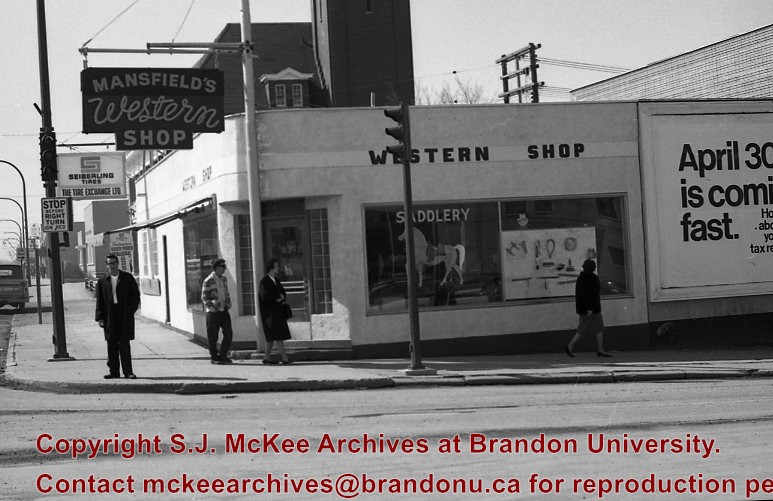
Mansfield's Western Shop was located on the corner of 6th Street and Princess Avenue at 603 Princess Avenue. The business appears to have been opened in 1966 by Ed and Jessie Mansfield. The shop was originally owened by Norman D. Moore and was called Moore's Western Shop. According to the Henderson's Brandon City Directory Mansfield's was relocated several times during its ownership. In 1967 Mansfields was reloacted to 737 11th Street, by 1973 had relocated again to 731 Princess Avenue and remained there until at least 1984. Mansfield's Western Shop had moved to it's final location at 1130 18th Street by 1988. Once Ed and Jessie retired the shop was taken over by their sons Les and Lyle Mansfield. Les and Lyle closed the store when they retired in 2015. Presently (2020) the H&Co Acadamy building stands where the original Mansfields Western Shop stood on 6th Street.
For images on the Central Fire Station see the McGuiness Collection (20-2009) and the Lawrence Stuckey Collection (1-2002)
Seiberling The Tire Exchange was located at 603 Princess Avenue next to Mansfield's Western Shop. The business appears to have been opened in 1963. The shop was originally owned by Norman D. Moore who bought the shop in 1945 and named the business Moores Tire Service. By 1972 Seiberling Tire Exchange had closed and Lyon's Tire City had opened and would remain there until 1976.
Custodial History
See Fonds level description for custodial history
Scope and Content
Image of the exterior of Mansfield's Western Shop looking on the corner of 6th Street and Princess Avenue.The image is looking west down Princess Avenue. Seiberling The Tire Exchange and the Central Fire Station are both visible west of Mansfield's Western Shop.
Notes
Hisotry/Bio information taken from Henderson's Directories. Description by Jillian Combs. Photo likely taken before April 30th based on the sign on the side of the building.
Photograph has been glued to a backing board that has warped over time
History / Biographical
On 16 November 1906, Manitoba was hit by a severe winter storm that began that Thursday evening and extended through the weekend. The Brandon Daily Sun ("Storm Extends Over a Large Territory," 17 Nov. 1906, 1) reported that rail and telegraph services had been disrupted, country roads were impassable, and business in town was at a stand still. Following the weekend, the daily reported the blizzard was one of the greatest in recent memory. CPR trains had been caught in drifts by Carberry and an express car had caught fire and was destroyed ("Worst Storm in Many Years," Brandon Daily Sun, 19 Nov. 1906, 1).
Scope and Content
Photograph shows street view of intersection of the 000 block of 8th Street and Rosser Avenue in the winter. Businesses on the east side of 8th Street from Pacific to Rosser Avenues are clearly visible and include: a Lunch Room (likely Aagaard's Lunch Counter), the Hotel Imperial Annex, Liverpool House (a boarding house), R.S. Thompson and Company Real Estate Office (Land Office), a barber shop (likely J. Coulter's), Frank Gowen photography studio. Fleming's Drug Store on the corner of 8th Street and Rosser Avenue has been replaced by the Bank of Hamilton. The Imperial Hotel is visible on the west side of 8th Street. The 8th Street Bridge is visible in the background. Men in winter coats and hats are crossing the street at the intersection. A horse-drawn sleigh is parked on 8th Street.
Notes
Writing on the front of the photograph matting reads: 340, after the storm November 1906. Page appears to be from a photo album. The photograph appears to be taken from the interior of a builing on the southwest corner of 8th Street and Rosser Avenue.
Gerry Beaubier was born in Wainwright, Alberta to Beatty and Babe Beaubier. He completed his high school in Saskatoon, before receiving a BSc in Geography from Brandon University.
Before attending university Gerry served in the army as a special reserve, while working as a night clerk at the Bessbourough Hotel in Saskatoon. His post-graduate career consisted primarily of work for Canada Agriculture, under the PFRA Branch (Prairie Farm Rehabilitation Administration). Later he would work as an Executive Manager, helping develop forage and range management programs for several post secondary schools, including, Assiniboine Community College, as well as schools in Red Deer, Lethbridge, and Saskatoon.
Gerry Beaubier married Joyce Abercrombie, of Saskatoon. Together they had two sons: Neil and Dean. Neil, an Account Advisor for the Royal Bank, was born in Regina, and currently works in Swift Current. Dean was born in Swift Current, received his PhD in Education and currently lives in Forrest working at Elton Collegiate.
The Beaubiers, who were originally from Ireland, emigrated to the Canadian West, making Gerry part of the fourth generation of his family to call the region home. His great-grandfather, along with his grandfather and great uncle were amongst the first one hundred settlers in Brandon. Together they first built the Beaubier House, a boarding house for early settlers and travellers. After it burnt down they began construction on the Beaubier Hotel, which stood at the corner of 8th Street and Princess Avenue in Brandon until August 17th, 2008. His grandfather, David Wilson Beaubier, continued to build and operate hotels throughout the prairies, including the Empire Hotels (of Brandon and Saskatoon) and The Park (Moose Jaw).
David Wilson Beaubier served as a secretary of the Orange Lodge of Manitoba. As an Orange Lodge Colonel, he worked with other Orange Lodge members, to recruit throughout the prairies for the purpose of World War One. For his efforts , David was promoted to Leftenant Colonel, and later Captain of the 99th Manitoba Rangers. David's sons (Gerry’s father, at University of Manitoba, and uncle at McGill), were both working towards undergraduate degrees when war broke out in 1914, and each would leave school to join their father at Camp Hughes.
Custodial History
Gerry Beaubier collected these photos primarily in the years 2000-2011, largely
from family and friends who knew of his interest in the topic. They were donated to the S.J. Mckee Archives in 2011.
Scope and Content
Collection consists of digital photographs of those who trained for battle in World War I at Camp Hughes and in Brandon, Manitoba. It also includes a digital copy of the cover of the Nominal Roll of Officers, Non-Commissioned Officers and Men, who departed from Brandon in 1917.
The photos, taken primarily at Camp Hughes, are of a number of battalions, including the 34th, 100th, 108th, 181st and 214th. The photo, PT in England, is a postcard sent home from Beaty Beaubier. The Massey Harris building seen on the right side of, WW1 B parade0001, was used to house troops throughout the war. The man standing alone at the front of the parade in, 181 Parade, is David Wilson Beaubier.
Notes
Information for the biographical and custodial histories was provided by Gerry Beaubier on September 25, 2013. Description by Dustin Lane (October 2013).
For custodial history see the collection level description of the Lawrence Stuckey collection.
Scope and Content
[View of Prince Edward Hotel under construction; looking south along Ninth Street.]
Notes
[Mr. Stuckey put six negatives (3 combined negatives) in one envelope. We have separated them and numbered them DC6f(1) through DC6f(6). From a combined negative.]
Photograph shows a view of downtown Brandon from the northeast corner of 10th Street and Princess Avenue. Thunderbird Bowl is in the foreground. Painted advertisements on the sides of buildings include: The Mitrou's Cafe and Tea Room and Brandon Musical Supply Ltd. Vehicles parked on 10th Street are facing north.
Notes
Photograph dated from "Tara's Bulba," the movie playing at the Strand Theatre and similiar vehicles captured in the photograph.
The Strome & White Co. General Store (L. foreground; built 1902) became Brandon Hardware & Brandon Hardware block, later Ashdowns; The final tenant was Stylerite Hardware with two floors of residential suites. It was destroyed by fire March 27, 1983
Custodial History
For custodial history see the collection level description of the Lawrence Stuckey collection.
Scope and Content
View of Rosser Avenue, looking east from Seventh Street
The Brandon Club (L. of center) was built in 1904. This local businessmen's club met in the old firehall until this building was erected by them.
[The Brandon Club closed and its assets were sold at auction on 18 June 2005. P.E. 01/06/2009]
Custodial History
For custodial history see the collection level description of the Lawrence Stuckey collection.
Scope and Content
Overhead view of Princess Avenue, west of 10th Street
Notes
Taken from roof of Prince Edward Hotel. Shows: Rat Portage Lumber Co., St. Matthew's Hall, Brandon Club, In distance Brandon College, International Harvester, Pumping Station. End of brick pavement at 14th Street is notable.


.jpg?width=1200&404=no-img.jpg&watermark=wmk)
.jpg?width=180&404=no-img.jpg)


.jpg%3fmaxheight%3d1000%26maxwidth%3d1000%26watermark%3dwmk&description=Prince+Edward+Hotel+Construction)
)