The International Peace Garden is situated on the international border between Manitoba and North Dakota, adjacent to the Canadian Border Services Boissevain port of entry and the U.S. Customs and Border Protection Agency's Dunseith port of entry. The dedication for the International Peace Garden was held on July 14, 1932. It was estimated that 50,000 people were in attendance on opening day. The park is 9.5-square kilometers or 3.54-square miles.
Custodial History
Pictures were sent to Fred McGuinness in 1970 from E.M. Bergson of Brandon.
Scope and Content
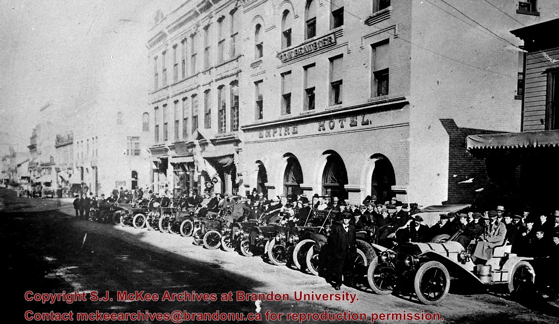
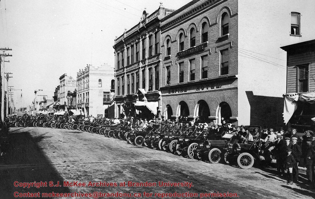
Photograph shows the crowded parking lot at the International Peace Garden's 1932 dedication ceremony. People mill amongst the automobiles and tents can be seen in the background.
Notes
The back of the photograph is stamped: Enameloid Velox Print by the Jul 27 1932, Chicago Postal Photo Supplies, Regina, Sask.
Frank Robb was Assistant Secretary Treasurer for School District of Brandon No. 129 and Curator of the B.J. Hales Natural History Museum exhibition for Brandon's 75th Anniversary (1957). Robb left Brandon ca. 1969 and relocated to Minaki, Ontario.
Custodial History
Frank Robb sent the slides to Fred McGuiness ca. 1986. McGuiness gave them to Eileen McFadden at the McKee Archives in April 1986.
Scope and Content
Fonds consists of 155 slides taken by Frank Robb, an inventory for the slides prepared by Robb and a letter from Robb to Fred McGuiness regarding the slides and memories of Brandon ca. 1950s.
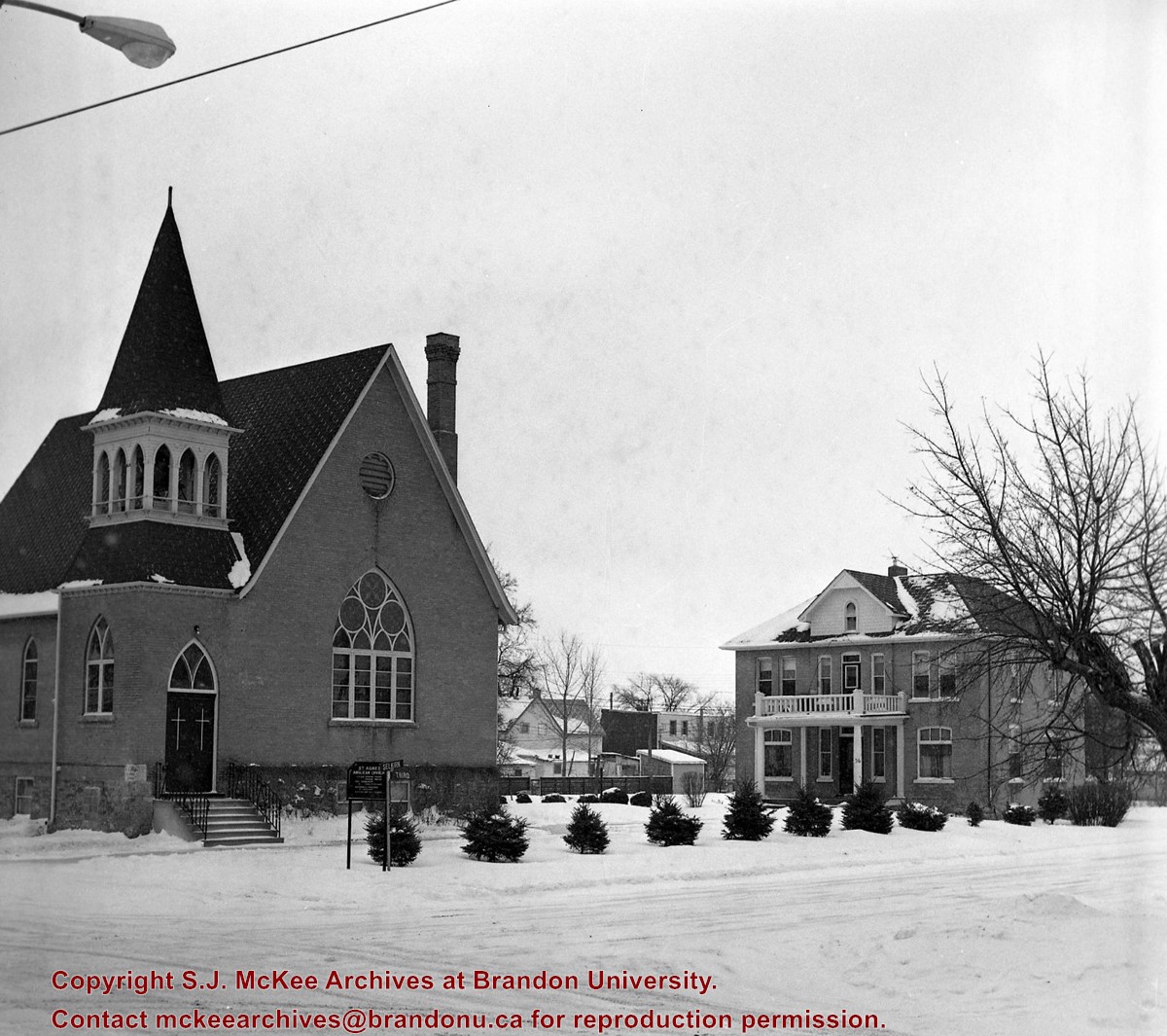
Photograph shows exterior views of five Brandon churches: Baptist Church, Presbyterian Church, St. Matthew's Church, Catholic Church and Monastery, and Methodist Church.
Notes
Part of "Christie's Brandon Series of Six Colored Picture Postcards of Brandon, Manitoba, The Crown Series, Published by Christie's Bookstore, Brandon, Man." [note: missing sixth postcard]. Writing on the front of the photograph reads: Baptist Church, Presbyterian Church Brandon Man., St. Matthew's Church, Catholic Church and Monastery, Methodist Church.
Photograph shows two separate views. One is of the main entrance of (Old) City Hall on Princess Avenue. The other view shows the ediface of the YMCA building as well as the adjacent St. Paul's United and First United Churches on 8th Street.
Notes
Part of "Souvenir of Brandon, Manitoba, Canada [viewbook], Printed by Photogelatine Engraving Co. Limited, Ottawa." Dates obtained from the Burchill's Music Store Henderson's Brandon City Directory listings (1927-1929). Writing on the front of the photograph reads: City Hall - Brandon, Man; YMCA, St. Paul's United & First Church United, Brandon, Man.
Photograph shows the 700-block of Rosser Avenue facing west. Visible businesses on the north side of Rosser Avenue include: Burchill's Music Store, E.W. Woolworth Co. Ltd. 5-10 and 15 Cent Store in the E.E. Evans Block, Empire Hotel, and W.A. Paterson Drugs. Automobiles are parked on both sides of the avenue and at the time the photograph was taken, Rosser Avenue was a two-way street.
Notes
Part of "Souvenir of Brandon, Manitoba, Canada [viewbook], Printed by Photogelatine Engraving Co. Limited, Ottawa." Dates obtained from the Burchill's Music Store Henderson's Brandon City Directory listings (1927-1929). Writing on the front of the photograph reads: Rosser St. [sic.] - Brandon, Man.
Photograph shows a street view of 10th Street facing north. There are many automobiles parked along the street and several pedestrians in summer dress are on the sidewalks and street. Visible business signs include: Hentzman & Co. Pianos (possibly belonging to J.J.H. McLean Co. Ltd.), the Strand Theatre, T & D Clothes, Campbell & Campbell, the CPR Station, and Bowling Alley and Billiards.
Notes
Part of "Souvenir of Brandon, Manitoba, Canada [viewbook], Printed by Photogelatine Engraving Co. Limited, Ottawa." Dates obtained from the Burchill's Music Store Henderson's Brandon City Directory listings (1927-1929). Writing on the front of the photograph reads: 10th St., looking north (C.P.R. Station at end of Street) Brandon, Man.
Red ink stain is on the front right corner of postcard
Scope and Content
Photograph shows 10th Street facing south from Princess Avenue. Visible landmarks and businesses include: Manitoba Power Commission (MPC)'s power sub-station, First Baptist Church, Wheat City Arena, and the grand stand at the Exhibition Grounds.
The partial sign visible at the bottom of the photograph on the east side of 10th Street reads Yates and Neale, which refers to a plumbing and heating company that dissolved in 1943 to be replaced by Neale, Stothard and Chapman.
Businesses on the west side of 10th Street include: Dominion Tire & Radio Co., Bolts Barber Shop, Elviss T.E. Co. Stables.
Notes
Information concerning Yates and Neale courtesy Jack Stothard. Writing on the front of the postcard reads: Brandon, Looking S.W., Jerrett Photo. This photograph shows a rare view of the 200-block of 10th Street.


+Church+and+manse%2c+Carberry%2c+Manitoba.)