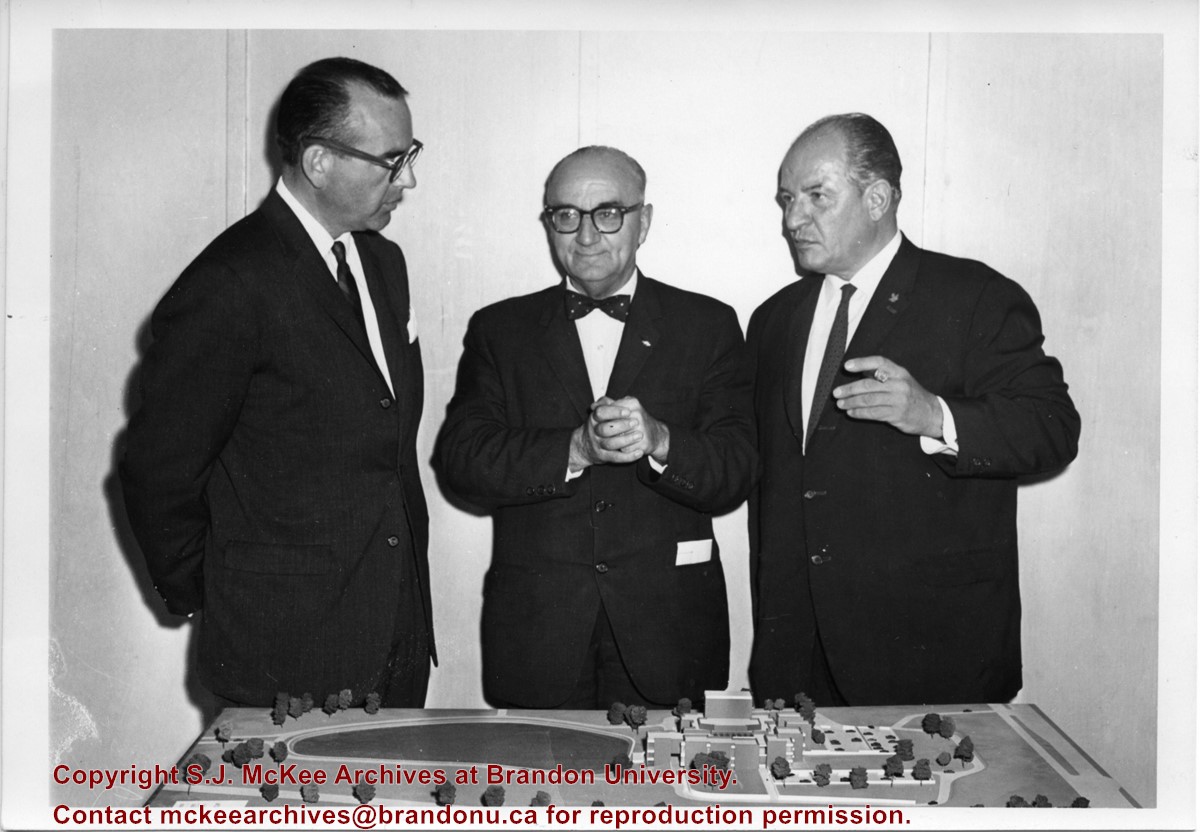
Photograph shows Fred McGuinness standing with Newfoundland Premier Joey Smallwood (centre) and the Centennial Commissioner John Fisher (right). The men are standing before an architectural model.
Notes
Writing on the back of the photograph reads: On tour of Newfoundland as member, board of directors Canadian Centennial Commission, McG, Premier Smallwood, & John Fisher, Centennial Commissioner, 1965
Photograph sent to Fred McGuinness from Leila McDiarmid Leck of Mission, BC, on 08 Feb 1983 in response to his Park School column (see F.A. Rosser, “Sunbeams – Park School reminiscences from a far away friends, Brandon Sun 25 Jan 1983)
Scope and Content
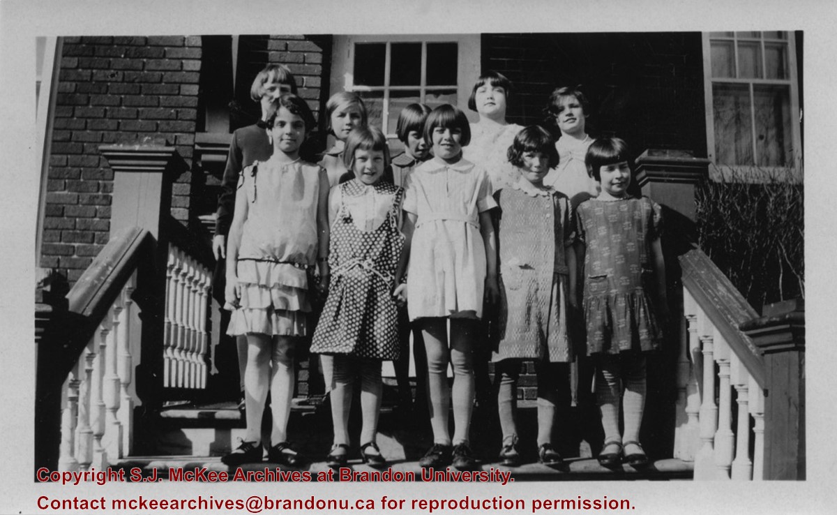
Photograph shows a group of young girls posing for a picture on the steps of residence. The girls had assembled fro Leila McDiarmid's 9th birthday.
Notes
Writing on the back of the photograph reads: Back Row - Mina Collins, Muriel Good, Lorna Lawrence, Evelyn Warren, Shirley Lane. Front - Doreen Donnelly, Leila McDiarmid, Jen Nicol, Phyllis Murdock, Florence Roberts. March 1930. (My 9th Birthday - Grade 3 with Helen Bennett.) Photograph is stamped: Crawford's Drug Store Brandon.
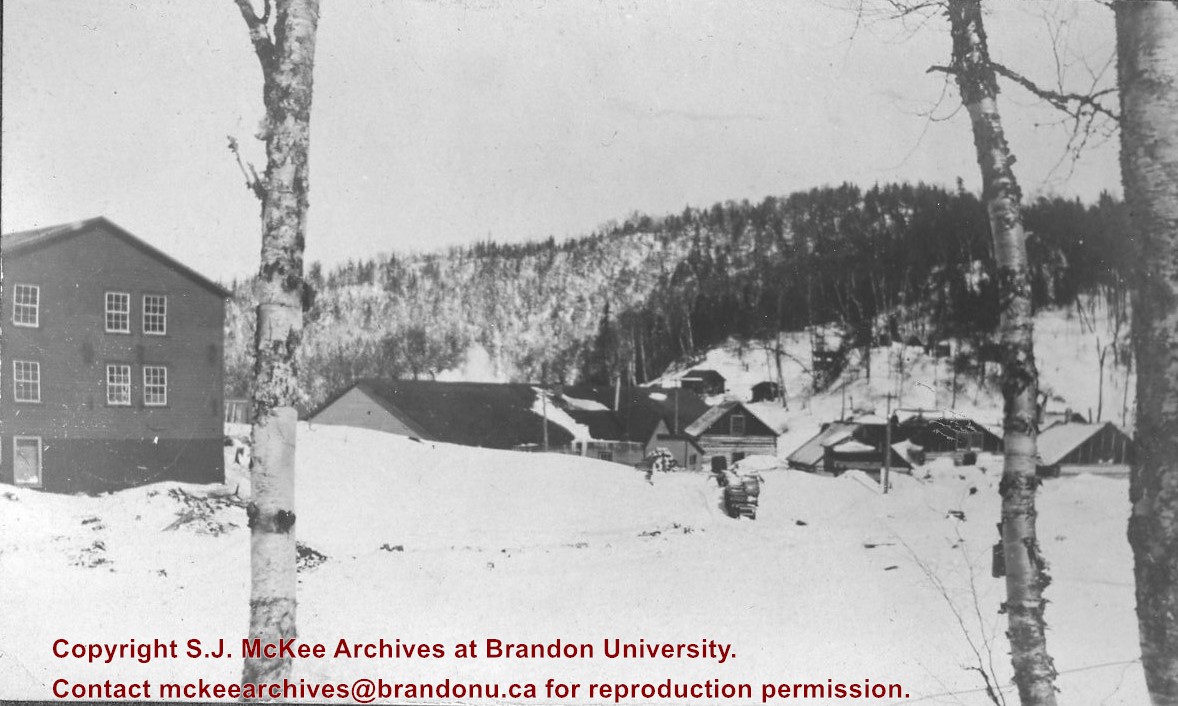
Postcard is of a combine bailing hay in the north end of Brandon at the junction of First Street and Veterans' Way. The Brandon city skyline is in the background and the orange Pioneer Grain elevator can be seen on the left side of the postcard.
Notes
Writing on the front of the postcard reads: Brandon, The Wheat City. Back of the postcard reads: Brandon the Agricultural and Industrial center for southwestern Manitoba; Photo by Sandy Black; Printed in Brandon, Manitoba, Canada, by Leech Printing Ltd.
These records were produced between 1987 and 1988, the researching and writing period for The Wheat City: A Pictorial History of Brandon monograph. Published in 1988 by Western Producer Books (Saskatoon, Saskatchewan), The Wheat City is a 117-page soft cover book, containing black and white images.
Western Producer Books pitched the book’s concept to Fred McGuinness in the fall of 1987. This book was part of the publisher’s “city series” which focused on smaller cities such as Medicine Hat and Prince Albert. It was estimated that the book would contain a 6,000-word introduction followed by approximately 80 archival photographs of Brandon spanning from early settlement to the late 1950s/early 1960s.
Brandon University history major Pam Svistovski worked as McGuinness’ research assistant and McGuinness obtained images for the book from his own personal collection, the Brandon Sun, Lawrence Stuckey, the Archives of Manitoba, and the Western Pictorial Index.
Custodial History
Records were collected and created by McGuinness during the writing phase of the monograph The Wheat City. The materials were donated to the SJ McKee Archives by the Estate of Fred McGuinness circa 2011. The Archives accessioned the records in 2015.
Scope and Content
The subseries consists of textual records and photographs created and collected during the production of the monograph The Wheat City. It includes correspondence, newspapers articles, drafts and black and white photographs from the Archives of Manitoba, Western Canada Pictorial Index, and Illustrated Souvenir of Brandon.
Notes
Information in the history/biography was obtained from The Wheat City’s acknowledgements and a letter to Mr. Fred McGuinness from Western Producer Books, dated September 24, 1987 (McG 5.6, File 11)
Where known, archival reference numbers for photographs obtained from the Archives of Manitoba and the Western Canada Pictorial Index and considered/used in The Wheat City have been provided in the item level description
Accruals
Closed
Repro Restriction
Images published in the monograph and stored in files copyright protected by their respective organizations
Finding Aid
A file level inventory is available
Storage Location
2015 accessions
Related Material
Clarence Hopkin collection
Lawrence Stuckey collection
Jack Stothard collection
Fred McGuinness would write/publish about a topic in a number of forums. Therefore, it is possible research materials pertaining to this monograph may be found in the Fred McGuinness collection subseries: Correspondence (McG 1.2), Brandon Sun (McG 2.2) Miscellaneous freelance (McG 3.2), Local history research (McG 4.1), Manitoba: The Province & The People (McG 5.4), and Manitoba Enterprise (McG 5.5)
Arrangement
Arrangement was artificially created by the Archives. Subseries has been re-arranged according to picture sources
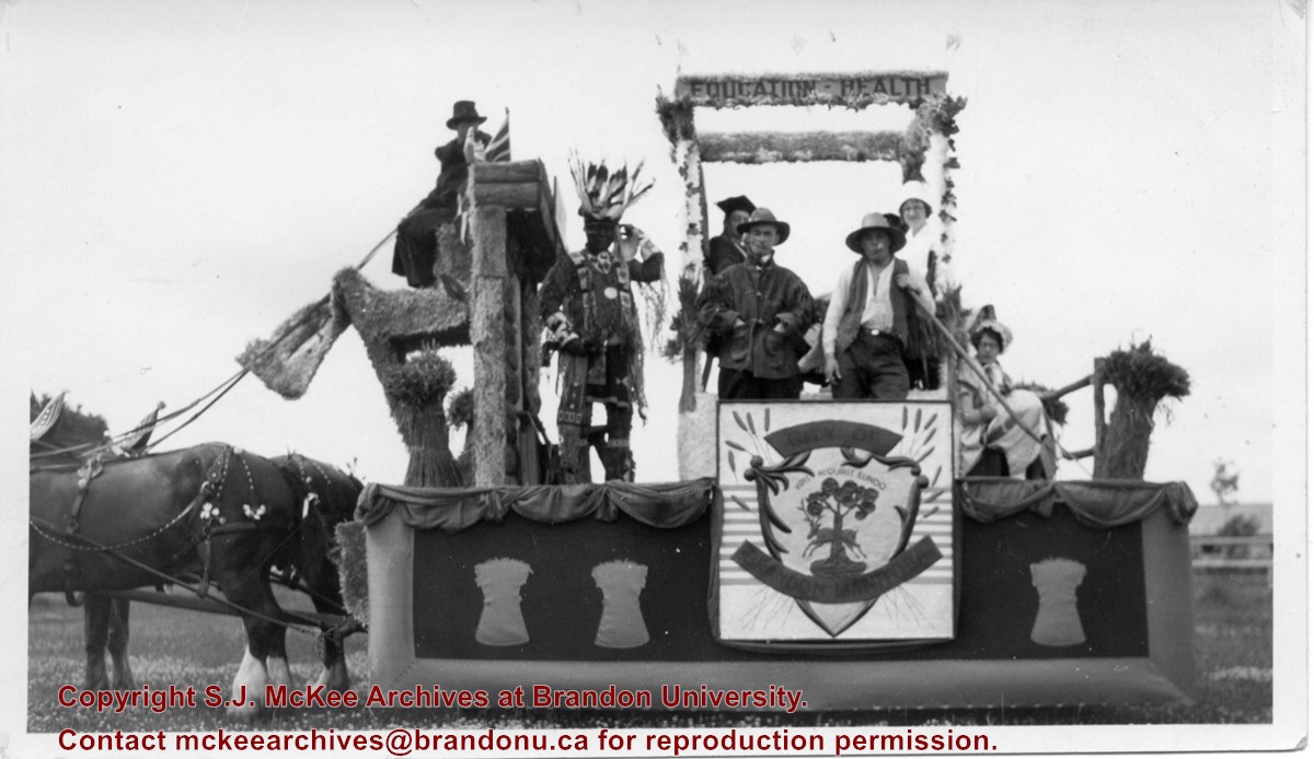
Photograph shows the City of Brandon parade float pulled by two clydesdale horses. The parade is in honour of the diamond anniversary of Canada's Confederation. The float is decorated with wheat sheaves, the city's coat of arms, and the words "education" and "health" adorn a pergola or arbour in the centre of the float. Seven people are on the float and appear to be in costume. An Aboriginal man is dressed in full regalia, one man appears to be in academic robes, another dressed as a farmer. One woman appears to be dressed like a nurse while another may be wearing a pioneer costume.
Notes
Writing on the back of the photograph reads: Brandon City's foat in 1927, Celebrating 60 years of Confederation, The lady in white is Miss Ann Carnahan who was on the city staff for a number of years and now resides in Victoria. She is my husbands [sic.] sister.
View is southwest from approximately 18th Street and Lorne Avenue. Photograph shows the Brandon University campus in winter, including: the Brandon University sign, the John R. Brodie Science Centre, the Citizens' Science Building and McMaster Hall.
View is southwest from the north side of Princess Avenue. Photograph shows the original Music Building, the north driveway entrance and parts of Clark Hall and the Brandon College building.
View is southwest from the sidewalk on the west side of 18th Street. Photograph shows the Brandon University sign, the front lawn, the Citizens' Science Building, McMaster Hall and the John R. Brodie Science Centre.
View is south from the north side of Princess Avenue. Photograph shows the walkway leading south across campus, the original Music Building, the A.E. McKenzie Building, the J.R.C. Evans Lecture Theatre, Flora Cowan Hall and Darrach Hall.
View is southwest from Princess Avenue. Photograph shows the original Music Building, the A.E. McKenzie Building, the J.R.C. Evans Lecture Theatre and Darrach Hall. Also visible are the field where the Western Manitoba Centennial Auditorium now stands, as well as a number of houses on 20th Street.
View is northeast fron the west side of the Dining Hall. Photograph shows portions of the J.R.C. Evans Lecture Theatre and the A.E. McKenzie Building, as well as an H-Hut, Clark Hall, the Brandon College Building and the quadrangle.
View is north from approximately the Citizens' Science Building. Photograph shows the driveway running in front of the Brandon College Building and Clark Hall, a number of cars and students along the driveway and the Education Building in the background.
View is south from the lawn in front of the Education Building and shows a student exiting the building. The driveway and John R. Brodie Science Centre are visible in the background.
Photograph has a couple of cracks, due to bending.
Scope and Content
View is northwest from the front lawn. Photograph shows the Brandon College Building, Clark Hall, the parking lot in front of those two buildings and the Education building.
View is east northeast from the sidewalk on the southeast corner of the George T. Richardson Centre (John R. Robbins Library). Photographs shows the campus during winter, including the Physical Plant and Development H-Huts, as well as the Brandon College Building and Clark Hall after the majority of the renovations were completed.
View is southwest from 18th Street, just north of the Brandon University sign. Tken during the summer, the photograph shows the front lawn, a portion of the flower bed, the Citizens' Science Building, the Knowles Douglas Students' Union Centre, the John R. Brodie Science Centre and McMaster Hall.
View is northeast. Photograph shows the green space before the Library extension in 1993. Brandon College Building and the Development H-Hut in the background.
View is northwest from the roof of the John R. Brodie Science Centre. Photograph shows part of McMaster Hall, the H-Huts, the Citzens' Science Building, the Brandon College Building and Clark Hall, the driveway, the J.R.C. Evans Lecture Theatre, the A.E. McKenzie Building and the Queen Elizabeth II Music Building.


