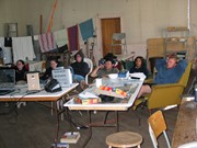
Numerous photographs were taken during the excavation of the Sarah site 2004. A selection of photographs of features and personnel performing usual field tasks such as surveying, measuring, excavating, and taking photographs were selected for the archive.
Scope and Content
Sub sub sub series consists of photographs taken during excavation of the Sarah site 2004.
The Sarah site was chosen for excavation based on the results of the Casselman survey. The survey recovered significant amounts of faunal remains, some ceramics and lithics from the test pits. Excavations took place in 2003 at Crepeele West (Units 1-5) and Crepeele East (Units 6-9). The site was subsequently renamed the Sarah site DiMe-28. In 2004 another 9 units were excavated (Units 10-18).
Based on the recoveries it was determined that the Sarah site is a stratified site with woodland ceramics in the upper occupation and late woodland points in both of the upper occupations. These upper occupations produced abundant bison bone including foetal bone. The lower occupations produced less bone and no foetal bone, although absence of foetal bone in the lower occupations does not necessarily indicate a warm season occupation. This could be due to sample error or perthotaxic factors such as scavenging of the fragile bone by dogs or other carnivores.
The dates from the Sarah site include 550+/-40 B.P.; 1430+/-80 B.P; 2810+/-80 B.P.; 3120+/-130 B.P. The lower occupations did not yield any diagnostic materials although debitage was abundant. These occupations were most productive at the edge of the large sand dune at the southern edge of the excavations. It is assumed that the major portion of these occupations have been overridden by the dune in the past 3000 years. Heavy earthmoving equipment would be required to remove this overburden which limits the possibility of future excavation.
Environment
The Sarah site is a large area located at the eastern end of the Crepeele locale. Ground cover is a mosaic of aspen poplar groves and patches of mesic grass prairie. Excavation profiles indicate that this has been the situation since early precontact times, although as local climatic conditions change (primarily rainfall), the relative size of these areas and where they may have occurred also changed. The soil is aeolian sand sheet derived from delta outwash deposits along the western edge of glacial Lake Hind. The present topography is a variable dune landscape reworked by aeolian activity that creates a mosaic of microhabitats. These include forested patches in the lee of sand dunes with grassland on the southern and western exposures and small damp lowlands that support balsam poplar, willows, red osier dogwood, high-bush cranberry and water birch. There is no permanent water source in the area although a small seasonal stream meanders through a damp lowland to the east of the Sarah site.
Scope and Content
Sub-series has been divided into sub sub series including: Sarah 2003 and Sarah 2004,
File consists of annual meeting mintues, proposed constitutional changes, correspondence, a nomination form, the records and statistics office draft format address plate, a mailing list and a copy of the Brandon University Alumni News 1969.
Storage Location
RG 6 Brandon University fonds
Series 4: Office of the Vice-President
4.2 Office of the Vice-President (Administration & Finance)
Box 4
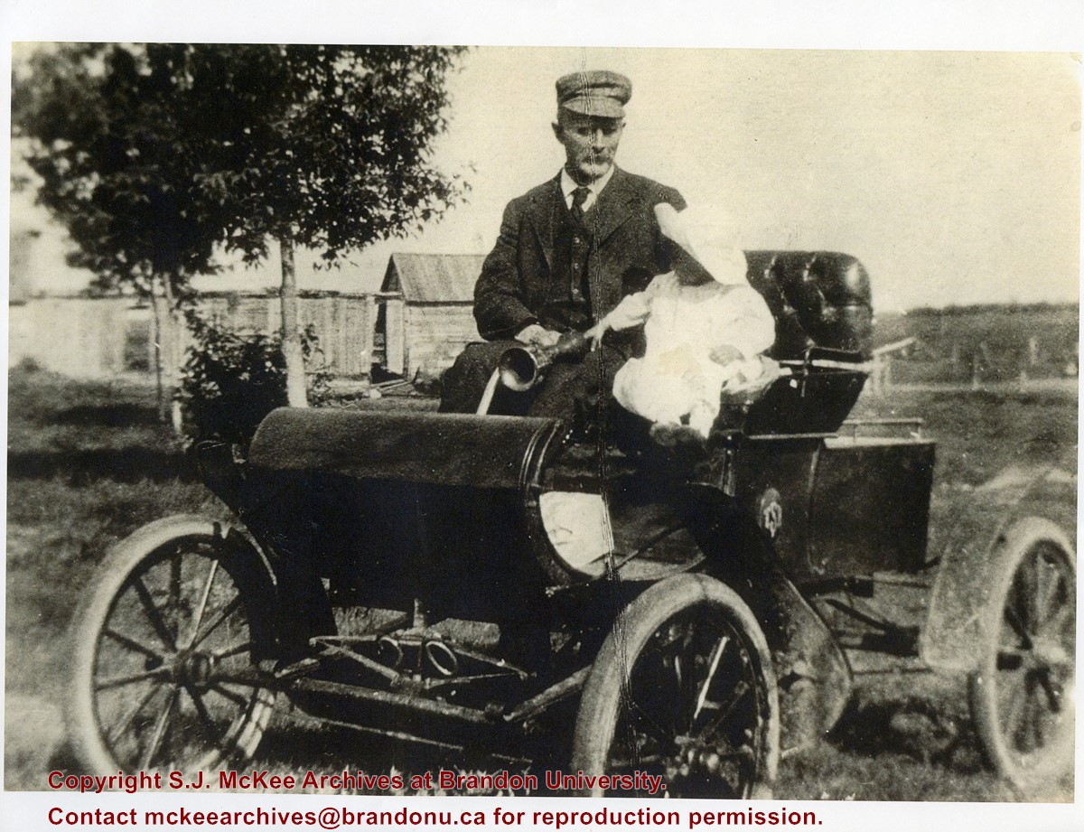
According to Fred McGuinness, Brandon's first automobile was purchased by Dr. Matheson. He sold the car to grocer William Muir.
Custodial History
Digital reproduction attached to correspondence addressed to Bax and Spouse from Fred McGuinness [2005]
Scope and Content
Photograph shows an elderly man holding a baby in an early motor car.
Notes
In correspondence addressed to Bax and Spouse from Fred McGuinness [2005], McGuinness identifies the man seated in the automobile as William Muir and the infant as Kelvin C. Baxter of Winnipeg [b.25 Mar 1908], grandson of Robert M. Coombs of Brandon.
Built 1882. Sold to Hughes & Co. July 1, 1905. Became part of Strathcona Block, built on front out to 10th Street in 1905.
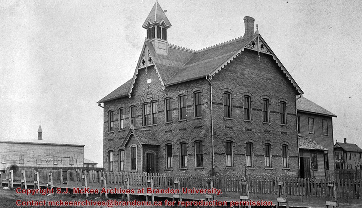
[From 1871 to 1890 the Manitoba school system was based on the Quebec model of religiously-aligned primary education. As such, Brandon’s first Central School was actually the first school built as part of the Brandon Protestant School Board. In contrast, St. Joseph’s Academy provided education to the children of Brandon’s Catholic community and was overseen by its own Catholic school board. Many non-secular school boards would be eliminated in Manitoba in 1890. (Mitchell, T. 1986. In the Image of Ontario: Public Schools in Brandon 1881-1890. Manitoba History, Number 12, Autumn 1986)]
Custodial History
For custodial history see the collection level description of the Lawrence Stuckey collection.
[First Baptist Church moved out of this building in the early 1990s. The building subsequently housed Solid Grounds (coffee shop), and Lady of the Lake (gift shop). C.H. 12/06/09]
Custodial History
For custodial history see the collection level description of the Lawrence Stuckey collection.
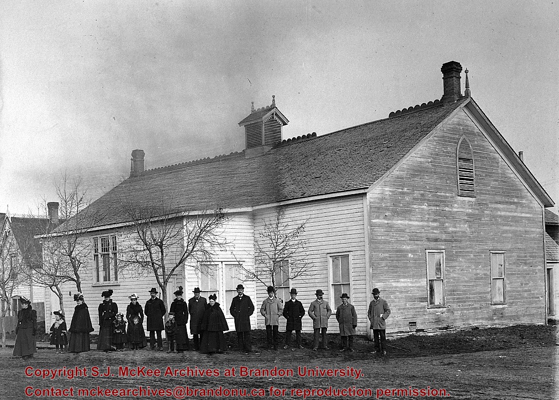
Brandon's first church; Showing renovations of 1895; A new building started construction in 1898, its cornerstone laid in 1899 by Mrs. Clifford Sifton.
Custodial History
For custodial history see the collection level description of the Lawrence Stuckey collection.
Scope and Content
First Methodist Church, 1881-1899
Notes
Located on 7th St. between Lorne & Louise Ave's.
People in photo, L to R: Mrs. Adams, Mrs. Leegh, Mrs. Van Tassel, Mrs. Ashley, B. Trotter, Mrs. Trotter, Rev. Leonard Gaetz, Mrs. Bodden, Rev. Darrel, J. Sproul, E. Bennest, D. Reesor, Mr. Bodden, T. Butcher; From collection of Central United Church.
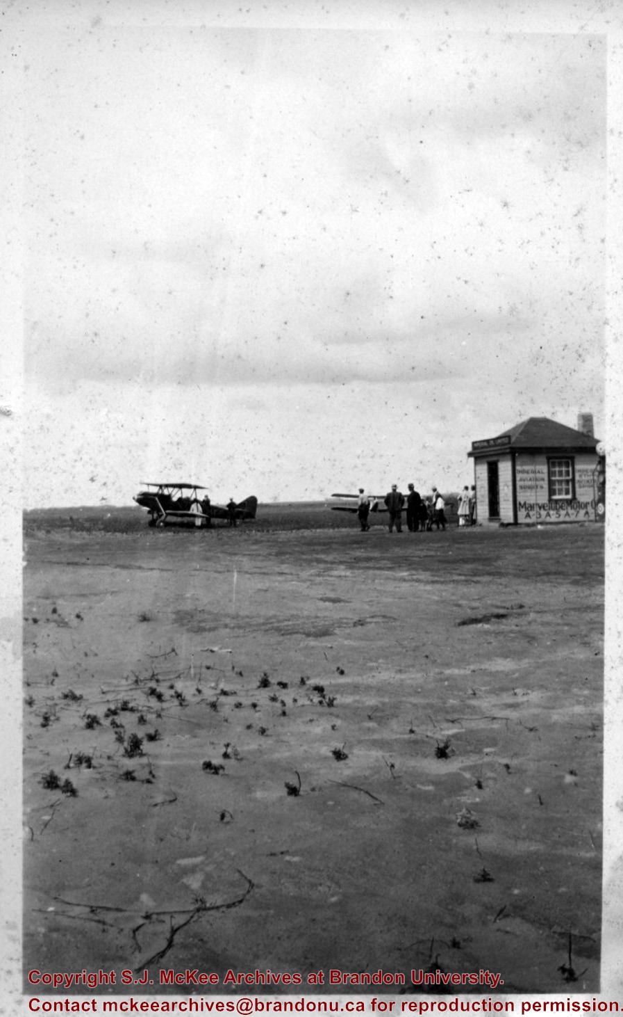
Due to the increasing volume of long-distance auto traffic in the 1920's, the city designated the block between Hill & Queen's Avenues and 9th & 10th streets as a "Tourist Camp" with a few basic facilities. LAS.
Custodial History
For custodial history see the collection level description of the Lawrence Stuckey collection.
Scope and Content
First Tourist Camp
Notes
Courtesy of the Brandon Sun
[Mr. Stuckey put two negatives in the same envelope, numbered N4 and N4a. We have separated them.]
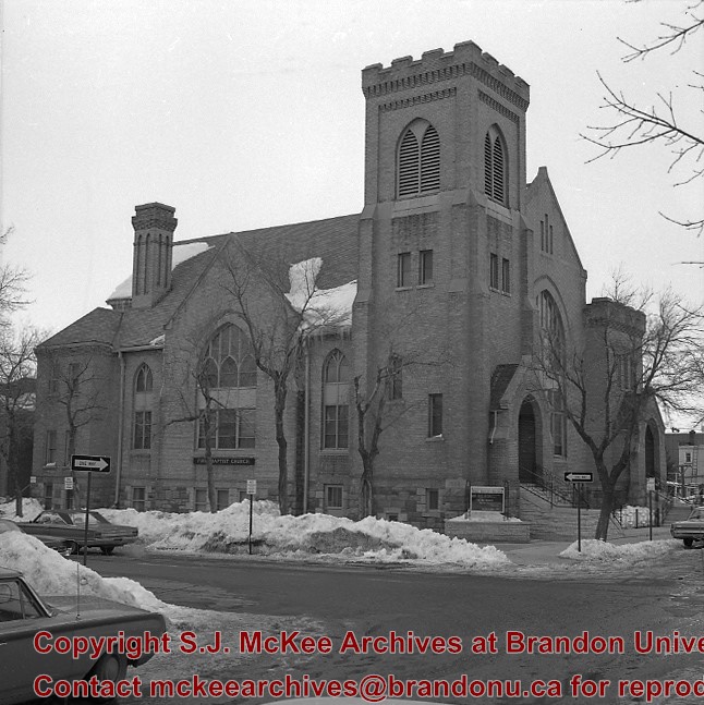
The First Baptist Church at the corner of 11th Street and Lorne Avenue was built in 1904 from the designs of W.A. Elliott. This was the Baptist congregation's second church; the first, a wood frame structure erected in 1885, stood on the southwest corner of 10th Street and Princess Avenue. A third church was built at 3881 Park Avenue, with the official dedication on October 16, 1994. At present (June 2007), the First Baptist Church in the photograph remains, but is unoccupied.
Custodial History
See fonds level description of the Alf Fowler collection for custodial history.
Scope and Content
Photo shows the First Baptist Church.
Notes
History/Bio information taken from the Assiniboine Historical Society's Brandon: An Architectural Walking Tour pamphlet (1982).
Storage Range
RG 5 Western Manitoba Manuscript collection - photograph storage drawer
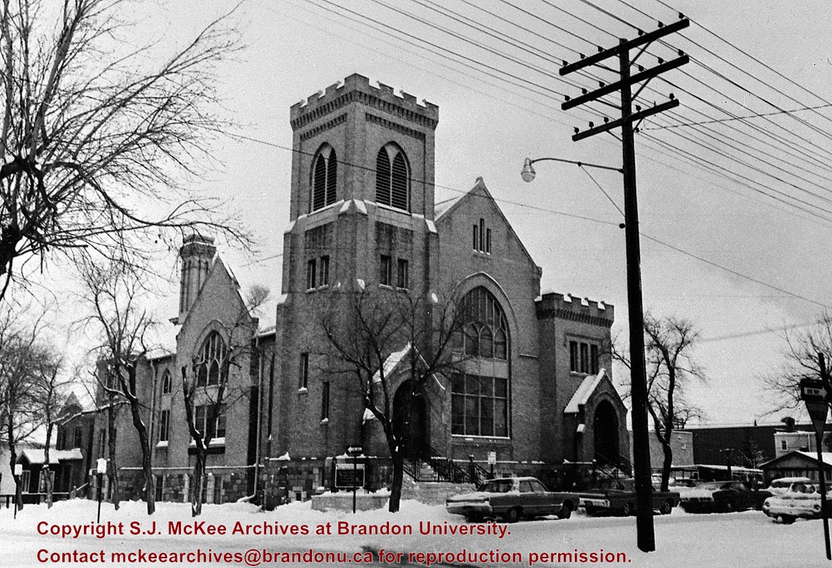
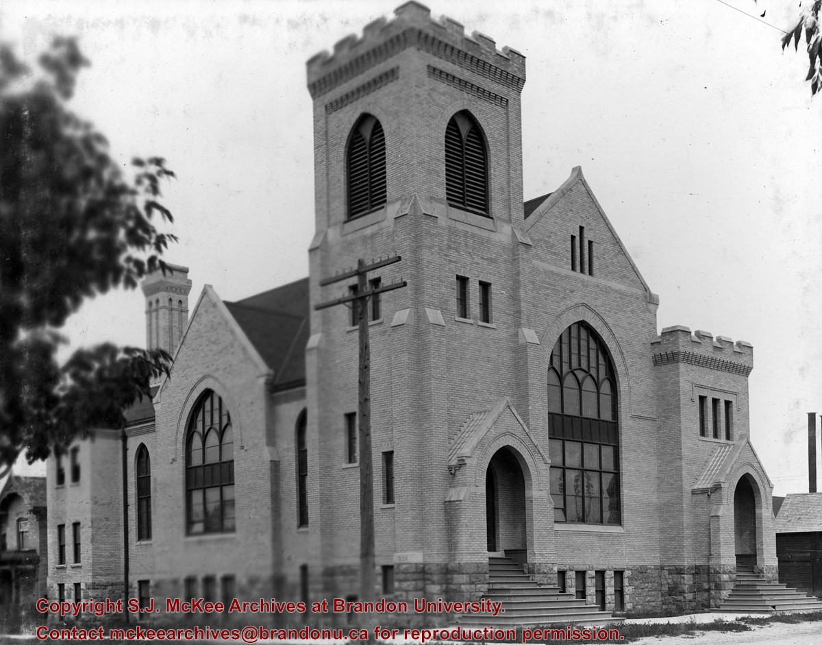
First Church United began as the First Methodist Church. It was renamed in c. 1925 and was located on the corner of 8th Street and Lorne Avenue, just south of the YMCA. From 1913-1919, A.E. Smith was the Methodist minister. The church was demolished c. 1975.
Scope and Content
Photograph is looking northeast and shows First Church United.
Repro Restriction
The McKee Archives is the copyright holder for the Stuckey materials.
Field journals have been scanned in multi-page PDF files. Artifact catalogues are PDF files in spreadsheet format. Photographs are in jpeg format.
History / Biographical
The Sarah site was initially chosen for excavation based on the results of the Casselman survey. The survey recovered significant amounts of faunal remains, some ceramics and lithics from the test pits. Excavations took place in 2003 at the Sarah site DiMe-28.
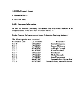
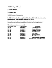
In 2004 further excavation took place as part of a Brandon University Archaeology Field School. Units 10 to 18 were excavated with Denise Ens as the instructor and James Graham teaching assistant.
Scope and Content
Sub-sub-sub series contains: Summary information of field methology, number and co-ordinates of excavations, personnel and their staff position.
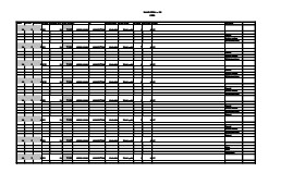
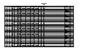
Artifact catalogue containing 2910 records from Sarah site 2004.
Scope and Content
Spreadsheet containing information about the artifacts recovered, including: unit, level, artifact number, catalogue number, depth, co-ordinates, entry date, date recovered,count, weight, UTM co-ordinates, notes(excavators initials and comments) and artifact identification.
.jpg?width=1200&404=no-img.jpg&watermark=wmk)
.jpg?width=180&404=no-img.jpg)
.jpg?width=1200&404=no-img.jpg&watermark=wmk)
.jpg?width=180&404=no-img.jpg)


.jpg%3fmaxheight%3d1000%26maxwidth%3d1000%26watermark%3dwmk&description=First+United+Church)
.jpg%3fmaxheight%3d1000%26maxwidth%3d1000%26watermark%3dwmk&description=First+United+Church)
.jpg%3fmaxheight%3d1000%26maxwidth%3d1000%26watermark%3dwmk&description=First+church+united)