View is west from approximatley 17th Street between Lorne and Louise Avenues. Photograph shows a portion of the Brandon University campus (excluding the Education Building and anything north of it), as well as surrounding residential blocks from approximatley 17th Street to 22nd Street.
View is west northwest from approximatley 16th Street and Louise Avenue. Photograph shows the Brandon University campus, prior to the Library Extension, and a large portion of the city to the west of the campus.
View is northwest from approximatley 16th Street and Louise Avenue. Photograph shows the Brandon University campus, prior to the Library Extension, and a large portion of the city to the west of the campus.
Image is looking east northeast from approximately the 300 block of 23rd Street between Lorne and Louise Avenues. Photograph shows the Brandon College campus after the opening of the original Music Building in 1963, but before the construction of the Education Building in 1966. A number of house on the 300 blocks of 22nd and 21st Streets are visible in the foreground, with the A.E. McKenzie Seed Co., the Prince Edward Hotel and various grain elevators on the horizon.
Photograph shows the 800 block of Rosser Avenue facing west. On the south side of Rosser Avenue the Nation Block, Christie's Bookstore, and Reesor's Clock can be seen. A number of horse and buggies/carriages are travelling along Rosser Avenue.
Photograph shows residential area of Lorne Avenue from 14th Street facing east.
Notes
Part of "Christie's Brandon Series of Six Colored Picture Postcards of Brandon, Manitoba, The Crown Series, Published by Christie's Bookstore, Brandon, Man." [note: missing sixth postcard]. Writing on the front of the photograph reads: Residential, Brandon, Man. Looking East.
Photograph shows a street view of Lorne Avenue and 4th Street facing west. Brandon College can be seen at the end of Lorne Avenue.
Notes
Part of "Christie's Brandon Series of Six Colored Picture Postcards of Brandon, Manitoba, The Crown Series, Published by Christie's Bookstore, Brandon, Man." [note: missing sixth postcard]. Writing on the front of the photograph reads: Residential Brandon, Man. Looking West. Photograph likely taken from St. Augustine's Church.
Postcard shows a street scene of Donald Street looking south from the Portage Avenue Intersection.
Notes
Writing on the back of the postcard reads: Aug 9, Dear ruth, Aunt Eva, Aunt Annie and Fred were over to the bowlnig greens tonight. Every one fine. Doddy. Postcard is addressed to Ruth McGuinness, 337-17th St., Brandon, Man. Postmarked: Winnipeg 12 PM Aug 10 1927 Man.
Justice Co-operative Elevator Association Limited Organizational papers: 1928 - 1969 Certificate of incorporation, 9 February 1928 Memo of Association and General By-laws, 9 February 1928 Memo re: Pool Elevator Policy and letter, 27 March 1928 First General Shareholders' meeting By-law nos. 1-7, 30 March 1928 First Provisional Directors' meeting, 30 March 1928 Lease, 1 August 1928 Elevator correction clause, 12 November 1929 Letter re: Lease, 23 November 1929 By-law nos. 8-11 and covering letter, 17 November 1930 By-law nos. 12 and 13, 22 July 1931 Application for stock, 22 July 1931 Shareholders meeting, 22 July 1931 Directors meeting, 22 July 1931 Agreement between Justice CEAL and MPEL, Manitoba Wheat Pool, and The King, 1 August 1931 By-law no. 14, 23 November 1931 One share of stock certificate, 1 December 1931 Agreement between Justice CEAL and MPEL, 1 February 1933 Special meeting of Board of Directors, 25 February 1933 Agreement between Justice CEAL and MPEL, 15 October 1936 By-law no. 16, 28 October 1939 Directors meeting, 28 October 1939 Shareholders meeting, 28 October 1939 By-law to authorize cancellation of share capital, 2 November 1940 Memo re: By-law no. 16, 24 March 1941 General By-laws and By-law nos. 18, 19, and 20, 27 June 1941 Memo on repeal By-law no. 19, no date By-law nos. 18, 19, 20 and General By-laws, no date Memo re: Agreement Justice CEAL and MPEL, 19 June 1944 By-law no. 21, 10 November 1947 Amendment to General By-laws, 6 May 1949 By-law no. 22, 19 May 1949 Agreement between Justice CEA and MPE, 19 February 1960 Letter re: above agreement, 3 August 1961 Directors' Resolution, 18 October 1961 Agreement between Justice CEAL and MPEL, 15 December 1966 By-law no. 26, 29 March 1967 Arrangement between Justice CEAL and members, 27 June 1969 Transfer agreement, no date Minutes of Executive Board meetings, volume 1, 20 April 1928 - volume 6, 7 March 1972 Minutes of Shareholders Annual meetings, 1938 (1 report) Financial records and statistics Statement of surplus, 1938 - 1944 (5 reports) Final statements, 1931 - 1944 (10 reports) Auditors' reports, 1929 - 1968 (40 reports) Detail of grain earnings, 1965 - 1968 (3 reports) Analysis of Operating Results, 1962 - 1967 (3 reports) Annual financial statement, no date Correspondence, 1954 - 1974 Membership list, 1961 Miscellaneous Corporate Name: Rural Municipality of Elton
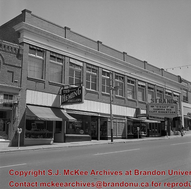
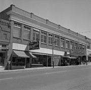
The Hughes block was built in 1916. It is located on the east side of the 100 block of 10th Street. The Strand Theatre opened November 27, 1916, and showed the city's first "talking" picture December 14, 1929. The Clark Smith Studio, to the right of the Strand sign, had been in the same approximate location since 1907, and eventually moved into the new building. The studio was purchased from Clark J. Smith by L.A. Stuckey on January 1, 1958.
Custodial History
For custodial history see the collection level description of the Lawrence Stuckey collection.
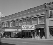


)
)