Skip header and navigation

Revise Search

20 records – page 1 of 1.

Aerial view: Brandon University campus

http://archives.brandonu.ca/en/permalink/descriptions2576
Part Of
Brandon University Photograph Collection
Description Level
Item
GMD
graphic
Date Range
September 21, 1999
Part Of
Brandon University Photograph Collection
Description Level
Item
Series Number
9
Item Number
BUPC 9.36
GMD
graphic
Date Range
September 21, 1999
Physical Description
11" x 14" (colour)
History / Biographical
The photograph was taken for the Centennial of Brandon College/University.
Scope and Content
Aerial photograph taken looking southwest from approximately the northeast corner of Princess Avenue and 17th Street. The entire campus, as well as a number of residential streets are visible.
Notes
Negative is located with the photograph
Subject Access
campus buildings
aerial photographs
aerial photography
aerial views
cityscapes
Storage Range
Oversized drawer 4
Images
Show Less

Aerial view of 10th Street facing south from Princess Avenue

http://archives.brandonu.ca/en/permalink/descriptions8420
Part Of
Joseph H. Hughes collection
Description Level
Item
GMD
graphic
Date Range
c.1940
Accession Number
3-1997
Part Of
Joseph H. Hughes collection
Creator
Photographer: Jerrett Photo
Description Level
Item
Series Number
3-1997.1
Item Number
3-1997.1.42
Accession Number
3-1997
GMD
graphic
Date Range
c.1940
Physical Description
5.5" x 3.5" (b/w)
Material Details
postcard
Physical Condition
Red ink stain is on the front right corner of postcard
Scope and Content
Photograph shows 10th Street facing south from Princess Avenue. Visible landmarks and businesses include: Manitoba Power Commission (MPC)'s power sub-station, First Baptist Church, Wheat City Arena, and the grand stand at the Exhibition Grounds. The partial sign visible at the bottom of the photograph on the east side of 10th Street reads Yates and Neale, which refers to a plumbing and heating company that dissolved in 1943 to be replaced by Neale, Stothard and Chapman. Businesses on the west side of 10th Street include: Dominion Tire & Radio Co., Bolts Barber Shop, Elviss T.E. Co. Stables.
Notes
Information concerning Yates and Neale courtesy Jack Stothard. Writing on the front of the postcard reads: Brandon, Looking S.W., Jerrett Photo. This photograph shows a rare view of the 200-block of 10th Street.
Name Access
Manitoba Power Company
10th Street
Dominion Tire & Radio Co.
T.E. Elviss Co. Stables
First Baptist Church
Subject Access
downtowns
street scenes
Brandon business buildings & facilities before 1940
aerial views
building exteriors
residences
churches
Storage Location
RG 5 photograph storage drawer
Images
Show Less

Lorne Avenue, looking west from St. Augustine's Church postcard

http://archives.brandonu.ca/en/permalink/descriptions13937
Part Of
Fred McGuinness collection
Description Level
Item
GMD
graphic
Date Range
1952
Accession Number
1-2015
Part Of
Fred McGuinness collection
Creator
Photograph by: J.V.
Description Level
Item
Series Number
McG 9
Item Number
1-2015.9
Accession Number
1-2015
GMD
graphic
Date Range
1952
Physical Description
5.5" x 3.5" (colour)
Material Details
postcard
Scope and Content
Photograph shows a western view of the residential area along Lorne Avenue from St. Augustine's Roman Catholic Church. Roof-tops of Central School, First Baptist, Brandon College, Manitoba Power Plant, and Old City Hall are visible.
Notes
Writing on the front of the postcard reads: Lorne Avenue, looking West from St. Augustine's R.C. Church, Brandon, Man. Writing on the back of the postcard reads: The Valentine & Sons Publishing Ltd., Montreal and London, Printed in Great Britain. A cancelled George VI purple Canada 3 cent stamp has been postmarked: Brandon SP 11 52.
Name Access
Lorne Avenue
Subject Access
residential streets
residences
churches
Storage Location
RG 5 photograph storage drawer 2 (hanging photos)
Arrangement
McG BR#9 - "Ashgrove Farms CBC"
Images
Show Less

Aerial view of Brandon postcard

http://archives.brandonu.ca/en/permalink/descriptions13867
Part Of
Fred McGuinness collection
Description Level
Item
GMD
graphic
Date Range
1970
Accession Number
20-2009
Part Of
Fred McGuinness collection
Creator
Photographer: R.J. "Bob" Snazel
Description Level
Item
Series Number
McG 9
Item Number
20-2009.177
Accession Number
20-2009
GMD
graphic
Date Range
1970
Physical Description
3.5" x 6" (colour)
Material Details
postcard
Scope and Content
Postcard shows an aerial view of the city of Brandon
Notes
Writing on the back of the postcard reads: No. 10. Brandon, Manitoba, Canada / Aerial View of Brandon / Distributed by Clements Drug Store / Brandon, Manitoba, Canada / Photos by: R.J. "Bob" Snazel. / Printed by: D.W. Friesen & Sons Ltd. Altona, Manitoba, Canada. The postcard is addressed to Mr. F.A. Rosser and is postmarked Brandon 30 May 1970. A 6-cent Queen Elizabeth red postage stamp portraying various modes of the transportation. The stamp has been cancelled with a postmark that reads "Help Retarded Children."
Name Access
City of Brandon
Subject Access
aerial photographs
aerial views
Repro Restriction
Canadian Copyright restrictions apply. Consult the Archivist.
Storage Location
RG 5 photograph storage drawer 2 (hanging photos)
Arrangement
From 20-2009 #1 File 13 Sunbeams
Images
Show Less

Christmas Tree Farm - aerial view

http://archives.brandonu.ca/en/permalink/descriptions13964
Part Of
Fred McGuinness collection
Description Level
Item
GMD
graphic
Date Range
[2009]
Accession Number
1-2015
Part Of
Fred McGuinness collection
Description Level
Item
Series Number
McG 9
Item Number
1-2015.36
Accession Number
1-2015
GMD
graphic
Date Range
[2009]
Physical Description
11" x 8.5" (colour)
Material Details
reproduction
Scope and Content
Colour photocopy shows an aerial view of the Fred McGuinness property - Christmas Tree Farm - on section 17.
Name Access
Christmas Tree Farm
Subject Access
residences
aerial photographs
farms
Storage Location
McGuinness oversize storage drawer (1-2015)
Arrangement
From RR #3 family letters
Images
Show Less

Aerial view: Brandon College

http://archives.brandonu.ca/en/permalink/descriptions594
Part Of
Brandon University Photograph collection
Description Level
Item
GMD
graphic
Date Range
[fall 1964?]
Part Of
Brandon University Photograph collection
Description Level
Item
Series Number
2.1
Item Number
BUPC 2.1.2
GMD
graphic
Date Range
[fall 1964?]
Physical Description
5" x 4" (b/w)
Scope and Content
Brandon College looking south from 19th Street. Photograph was taken after Flora Cowan Hall was built but before construction of the Education Building.
Subject Access
aerial photographs
campus photographs
campus buildings
Brandon streets
Images
Show Less

Aerial view - Brandon University campus

http://archives.brandonu.ca/en/permalink/descriptions7989
Part Of
Brandon University Photograph collection
Description Level
Item
GMD
graphic
Date Range
c. 2000
Part Of
Brandon University Photograph collection
Creator
Photograph commissioned by Brandon University and taken by Yourview Aerial Scenics Ltd.
Description Level
Item
Series Number
2.1
Item Number
BUPC 2.1.55
GMD
graphic
Date Range
c. 2000
Physical Description
6" x 4" (colour)
Scope and Content
View is southwest from approximatley 16th Street between Princess and Rosser Avenues. Photograph shows the Brandon University campus, as well as surrounding residential blocks, including Flemming, J.R. Reid and Vincent Massey schools.
Subject Access
aerial photographs
campus photographs
campus buildings
Brandon streets
Images
Show Less

Aerial view - Brandon University campus

http://archives.brandonu.ca/en/permalink/descriptions7990
Part Of
Brandon University Photograph collection
Description Level
Item
GMD
graphic
Date Range
c. 2000
Part Of
Brandon University Photograph collection
Creator
Photograph commissioned by Brandon University and taken by Yourview Aerial Scenics Ltd.
Description Level
Item
Series Number
2.1
Item Number
BUPC 2.1.56
GMD
graphic
Date Range
c. 2000
Physical Description
6" x 4" (colour)
Scope and Content
View is west southwest from approximatley 16th Street between Princess and Lorne Avenues. Photograph shows the Brandon University campus, as well as surrounding residential blocks between 16th and 23rd Streets, Princess and Louise Avenues..
Subject Access
aerial photographs
campus photographs
campus buildings
Brandon streets
Images
Show Less

Aerial view - Brandon University campus

http://archives.brandonu.ca/en/permalink/descriptions7991
Part Of
Brandon University Photograph collection
Description Level
Item
GMD
graphic
Date Range
c. 2000
Part Of
Brandon University Photograph collection
Creator
Photograph commissioned by Brandon University and taken by Yourview Aerial Scenics Ltd.
Description Level
Item
Series Number
2.1
Item Number
BUPC 2.1.57
GMD
graphic
Date Range
c. 2000
Physical Description
6" x 4" (colour)
Scope and Content
View is west from approximatley 17th Street between Lorne and Louise Avenues. Photograph shows a portion of the Brandon University campus (excluding the Education Building and anything north of it), as well as surrounding residential blocks from approximatley 17th Street to 22nd Street.
Subject Access
aerial photographs
campus photographs
campus buildings
Brandon streets
Images
Show Less

Aerial view - Brandon University campus

http://archives.brandonu.ca/en/permalink/descriptions7992
Part Of
Brandon University Photograph collection
Description Level
Item
GMD
graphic
Date Range
c. 1990
Part Of
Brandon University Photograph collection
Description Level
Item
Series Number
2.1
Item Number
BUPC 2.1.58
GMD
graphic
Date Range
c. 1990
Physical Description
5" x 3.5" (colour)
Scope and Content
View is west northwest from approximatley 16th Street and Louise Avenue. Photograph shows the Brandon University campus, prior to the Library Extension, and a large portion of the city to the west of the campus.
Subject Access
aerial photographs
campus photographs
campus buildings
Brandon streets
Images
Show Less

Aerial view - Brandon University campus

http://archives.brandonu.ca/en/permalink/descriptions7993
Part Of
Brandon University Photograph collection
Description Level
Item
GMD
graphic
Date Range
c. 1990
Part Of
Brandon University Photograph collection
Description Level
Item
Series Number
2.1
Item Number
BUPC 2.1.59
GMD
graphic
Date Range
c. 1990
Physical Description
5" x 3.5" (colour)
Scope and Content
View is northwest from approximatley 16th Street and Louise Avenue. Photograph shows the Brandon University campus, prior to the Library Extension, and a large portion of the city to the west of the campus.
Subject Access
aerial photographs
campus photographs
campus buildings
Brandon streets
Show Less

Aerial view - Brandon College looking southwest

http://archives.brandonu.ca/en/permalink/descriptions601
Part Of
Brandon University Photograph collection
Description Level
Item
GMD
graphic
Date Range
[1963-1966]
Part Of
Brandon University Photograph collection
Description Level
Item
Series Number
2.1
Item Number
BUPC 2.1.8
GMD
graphic
Date Range
[1963-1966]
Physical Description
5" x 4" (b/w)
Scope and Content
Image shows the Brandon College campus from 17th Street looking southwest. The photo was taken after the completion of the original Music Building in 1963, but construction of the Education Building. Also visible are a number of properties on the 200 block of 18th Street and the 200 block of 20th Street.
Subject Access
aerial photographs
campus photographs
campus buildings
Brandon streets
Images
Show Less

Mrs. Scott's residence, Kemnay 1893

http://archives.brandonu.ca/en/permalink/descriptions13689
Part Of
Fred McGuinness collection
Description Level
Item
GMD
graphic
Date Range
1893
Accession Number
6-2008
Part Of
Fred McGuinness collection
Creator
Photographer: Irwin
Description Level
Item
Series Number
McG 9
Item Number
6-2008.3
Accession Number
6-2008
GMD
graphic
Date Range
1893
Physical Description
9.5" x 7" (b/w)
Material Details
On matting
Physical Condition
Foxing on matting and photograph, primarily along edges of photograph
Custodial History
Mona McKinnon (nee Corkish) gave photograph to Colleen McGuinness who, in turn, gave it to her father, Fred McGuinness in 2007.
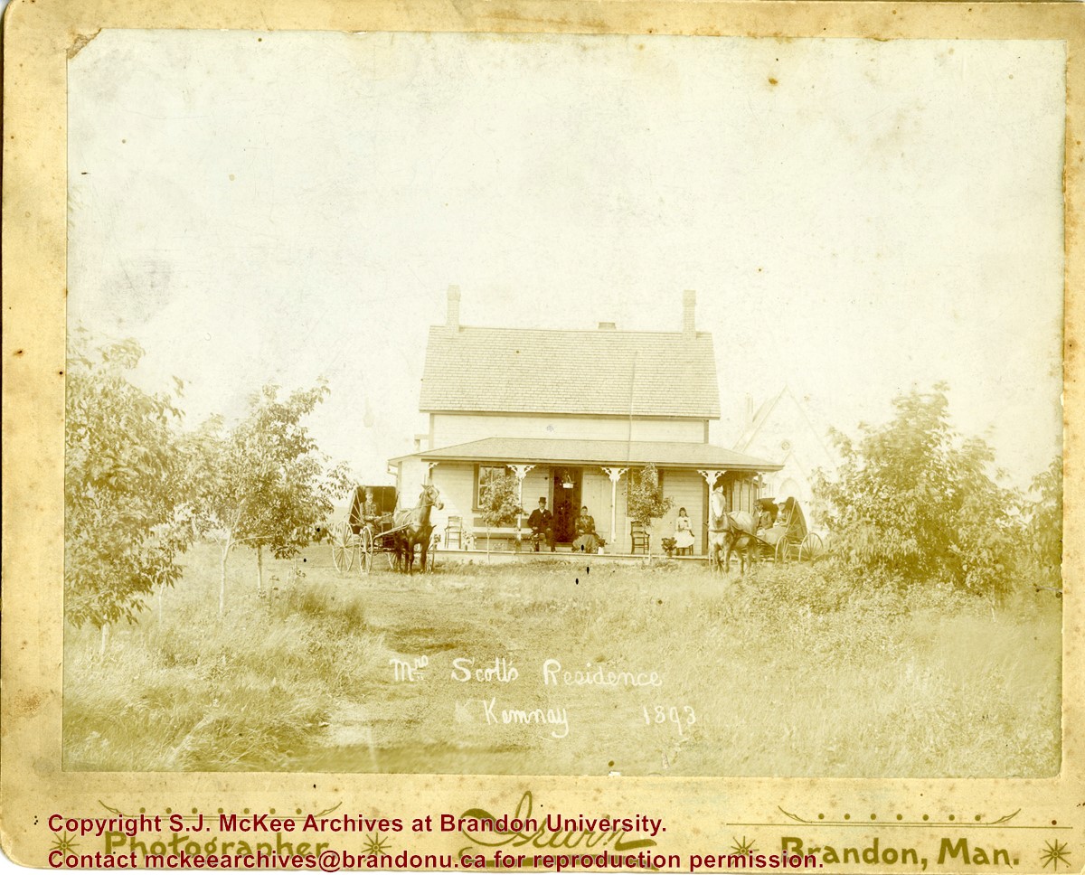
Scope and Content
Photograph shows Mrs. Scott's residence in Kemnay, Manitoba. Members of the family along with two horse-drawn buggies are clearly visible along the front of the house. A possbile church appears to the right of the house in the background.
Notes
Writing on the back of the photograph reads: Margaret Brown Scott, Mother in law to, Frank McGee Sr.
Name Access
Kemnay, MB
Margaret Brown Scott
Subject Access
residences
early transportation
buggies
churches
Rural Manitoba
Storage Location
McGuinness oversize storage drawer (1-2015)
Images
Show Less

Aerial view: Brandon College from 23rd Street

http://archives.brandonu.ca/en/permalink/descriptions602
Part Of
Brandon University Photograph collection
Description Level
Item
GMD
graphic
Date Range
[1963-1966]
Part Of
Brandon University Photograph collection
Description Level
Item
Series Number
2.1
Item Number
BUPC 2.1.9
GMD
graphic
Date Range
[1963-1966]
Physical Description
5" x 4" (b/w)
Scope and Content
Image is looking east northeast from approximately the 300 block of 23rd Street between Lorne and Louise Avenues. Photograph shows the Brandon College campus after the opening of the original Music Building in 1963, but before the construction of the Education Building in 1966. A number of house on the 300 blocks of 22nd and 21st Streets are visible in the foreground, with the A.E. McKenzie Seed Co., the Prince Edward Hotel and various grain elevators on the horizon.
Subject Access
aerial photographs
campus photographs
campus buildings
Brandon streets
Grain elevators
Images
Show Less

Twin Pines Motel postcard

http://archives.brandonu.ca/en/permalink/descriptions13868
Part Of
Fred McGuinness collection
Description Level
Item
GMD
graphic
Date Range
1970
Accession Number
20-2009
Part Of
Fred McGuinness collection
Creator
Photographer: Joe Fartak
Description Level
Item
Series Number
McG 9
Item Number
20-2009.178
Accession Number
20-2009
GMD
graphic
Date Range
1970
Physical Description
3.5" x 6" (colour)
Material Details
postcard
Scope and Content
Postcard shows an exterior view of the Twin Pines Motel
Notes
Writing on the back of the postcard reads: Twin Pines Motel & Restaurant / Brandon, Manitoba, Canada / Located at 10th Street & Queens Avenue / 40 Fully modern units with bath & showers, T. / Kichenettes, winter plug-ins, Ample parking. / For reservations call.... / 30717-C Color Photo by Joe Fartak / Color Productions Ltd., Box 1243, Regina, Sask. The postcard is addressed to Mr. F.A. Rosser and is postmarked Brandon 06 June 1970. A 6-cent Queen Elizabeth red postage stamp portraying various modes of the transportation.
Name Access
City of Brandon
Subject Access
aerial photographs
aerial views
Brandon business buildings & facilities after 1940
Storage Location
RG 5 photograph storage drawer 2 (hanging photos)
Arrangement
From 20-2009 #1 File 13 Sunbeams
Images
Show Less

100-block 10th Street, facing west (3)

http://archives.brandonu.ca/en/permalink/descriptions8408
Part Of
Joseph H. Hughes collection
Description Level
Item
GMD
graphic
Date Range
c. 1955
Accession Number
3-1997
Part Of
Joseph H. Hughes collection
Creator
Photographer: R.M. Coleman
Description Level
Item
Series Number
3-1997.1
Item Number
3-1997.1.30
Accession Number
3-1997
GMD
graphic
Date Range
c. 1955
Physical Description
8 " x 5" (b/w)
Physical Condition
good
Scope and Content
Photograph shows the west side of 10th Street between Rosser and Princess Avenues in the winter. Visible businesses include: Bottomley's, Simpsons-Sears, Lionel Electric, Allied Hardware Stores, Box Brothers Hardware, Doig's. Painted on the north face of the Strathcona Block are two advertisements, one for Sutherland and Robertson [Grocery] and the other for Boyd Electric Co. Ltd.
Name Access
10th Street
Bottomley's
Simpsons-Sears Ltd.
Lionel Electric
Sutherland and Robertson
Boyd Electric Co. Ltd.
Strathcona Block
Box Brothers Hardware
Doig's
Allied Hardware
Alexandra Block
Subject Access
downtowns
street scenes
Brandon business buildings & facilities after 1940
building exteriors
winter
Storage Location
RG 5 photograph storage drawer
Images
Show Less

Rosser Avenue between 7th and 8th Streets, south side, Brandon, Manitoba

http://archives.brandonu.ca/en/permalink/descriptions8421
Part Of
Joseph H. Hughes collection
Description Level
Item
GMD
graphic
Date Range
c.1960s
Accession Number
3-1997
Part Of
Joseph H. Hughes collection
Creator
Photographer: R.M. Coleman
Description Level
Item
Series Number
3-1997.1
Item Number
3-1997.1.43
Accession Number
3-1997
GMD
graphic
Date Range
c.1960s
Physical Description
8" x 5" (b/w)
Physical Condition
good
History / Biographical
The Royal Bank moved to this location on 26 October 1929. An existing building was renovated to accomodate the bank. On 28 May 1976 fire destroyed the buildings from the lane west to the Royal Bank.
Scope and Content
Photograph shows the south side of Rosser Avenue between 7th and 8th Streets, west of the Eaton's building. Visible shops include: Vogue [Ladies Wear], Smith's Drugs, Sobie's Tailored Undergarnments, Household Finance Loans, and The Royal Bank of Canada.
Name Access
Vogue Ladies Wear
Smith's Drugs
Sobie's
Household Finance Loans
Royal Bank of Canada
Subject Access
downtowns
street scenes
Brandon business buildings & facilities after 1940
building exteriors
winter
Storage Location
RG 5 photograph storage drawer
Images
Show Less

British American dealers - aerial view looking north at intersection of Highways 1 and 10

http://archives.brandonu.ca/en/permalink/descriptions11240
Part Of
CKX fonds
Description Level
Item
GMD
graphic
Date Range
after 1954
Accession Number
11-2010
Part Of
CKX fonds
Creator
CKX
Description Level
Item
Item Number
11-2010.B3u
Accession Number
11-2010
GMD
graphic
Date Range
after 1954
Physical Description
5" x 4" (b/w)
Material Details
Negative
Custodial History
See fonds level of the CKX records for custodial history.
Scope and Content
Image consists of an aerial view looking north at the intersection of Highways 1 and 10 and shows the British American dealer located at the intersection.
Name Access
CKX
British American Dealers
Brandon, Manitoba
Subject Access
aerial photographs
Storage Location
CKX fonds - 2010 accessions
Images
Show Less

British American dealers - aerial view looking southeast from intersection of Highways 1 and 10

http://archives.brandonu.ca/en/permalink/descriptions11242
Part Of
CKX fonds
Description Level
Item
GMD
graphic
Date Range
after 1954
Accession Number
11-2010
Part Of
CKX fonds
Creator
CKX
Description Level
Item
Item Number
11-2010.B3v
Accession Number
11-2010
GMD
graphic
Date Range
after 1954
Physical Description
5" x 4" (b/w)
Material Details
Negative
Custodial History
See fonds level of the CKX records for custodial history.
Scope and Content
Image consists of an aerial view looking southeast at the intersection of Highways 1 and 10 and shows the British American dealer located at the intersection.
Name Access
CKX
British American Dealers
Brandon, Manitoba
Subject Access
aerial photographs
Storage Location
CKX fonds - 2010 accessions
Images
Show Less

British American dealers - aerial view looking northeast from intersection of Highways 1 and 10

http://archives.brandonu.ca/en/permalink/descriptions11243
Part Of
CKX fonds
Description Level
Item
GMD
graphic
Date Range
after 1954
Accession Number
11-2010
Part Of
CKX fonds
Creator
CKX
Description Level
Item
Item Number
11-2010.B3w
Accession Number
11-2010
GMD
graphic
Date Range
after 1954
Physical Description
5" x 4" (b/w)
Material Details
Negative
Custodial History
See fonds level of the CKX records for custodial history.
Scope and Content
Image consists of an aerial view looking northeast at the intersection of Highways 1 and 10 and shows the British American dealer located at the intersection.
Name Access
CKX
British American Dealers
Brandon, Manitoba
Subject Access
aerial photographs
Storage Location
CKX fonds - 2010 accessions
Images
Show Less

20 records – page 1 of 1.