The Medicine Hat Exhibition and Stampede Parade Day was held on Thursday, July 19, 1962, at 9:30 a.m. The local newspaper reported that approximately 24,000 people were in attendance to see parade marshall Rod Ashburner leading 175 entries consisting of 90 floats, 75 horses, and 10 bands. There were 19 parade categories eligible for $12,000 in prize money and included: junior and senior cowboys and cowgirls; fancy and Shetland ponies; sulky class open; comic, commercial, industrial and organizational floats; decorated cars; special ranch class; 4-H Clubs; and a non-competitive class.
The parade route started at Second St. and Allowance Ave., from Second St. to Ash Ave., north on Ash to First St. SE., from First St. S.E. to Fourth Ave., south to Second St. to South Railway St., south on South Railway St. to Third St., with a finish at McLeod Trail. A route map was published in the Medicine Hat News the day before the parade.
Aerial photographs of the parade were taken by Medicine Hat News photographer Howard Heid (1930-2005) from the private helicopter of John Bourn. Bourn was a pilot from Woodville, Wisconsin, who chartered his four-seater helicopter for sight-seers at exhibitions and stampedes across the county.
(Sources: Pat Currie, "Let 'Er Go!," Medicine Hat News, 19 July 1962,1; Harald Gunderson, "'Eye in the Sky' Best Parade View," Medicine Hat News, 19 July 1962,1; "Parade Starts at 9:30 Sharp," 18 July 1962)
Scope and Content
Photograph shows an aerial view of the Medicine Hat Exhibition and Stampede Parade route with a focus on the First Street SE and and the South Railway Street merge. A number of gas stations and garages are visible along this route and include Texaco, Shell, Ford, and B/A. The Fraternal Order of Eagles lodge is also visible.
Notes
This photograph shows the neighbourhood before rezoning and commercial development.
Photograph shows residential area of Lorne Avenue from 14th Street facing east.
Notes
Part of "Christie's Brandon Series of Six Colored Picture Postcards of Brandon, Manitoba, The Crown Series, Published by Christie's Bookstore, Brandon, Man." [note: missing sixth postcard]. Writing on the front of the photograph reads: Residential, Brandon, Man. Looking East.
Photograph shows a street view of Lorne Avenue and 4th Street facing west. Brandon College can be seen at the end of Lorne Avenue.
Notes
Part of "Christie's Brandon Series of Six Colored Picture Postcards of Brandon, Manitoba, The Crown Series, Published by Christie's Bookstore, Brandon, Man." [note: missing sixth postcard]. Writing on the front of the photograph reads: Residential Brandon, Man. Looking West. Photograph likely taken from St. Augustine's Church.
Red ink stain is on the front right corner of postcard
Scope and Content
Photograph shows 10th Street facing south from Princess Avenue. Visible landmarks and businesses include: Manitoba Power Commission (MPC)'s power sub-station, First Baptist Church, Wheat City Arena, and the grand stand at the Exhibition Grounds.
The partial sign visible at the bottom of the photograph on the east side of 10th Street reads Yates and Neale, which refers to a plumbing and heating company that dissolved in 1943 to be replaced by Neale, Stothard and Chapman.
Businesses on the west side of 10th Street include: Dominion Tire & Radio Co., Bolts Barber Shop, Elviss T.E. Co. Stables.
Notes
Information concerning Yates and Neale courtesy Jack Stothard. Writing on the front of the postcard reads: Brandon, Looking S.W., Jerrett Photo. This photograph shows a rare view of the 200-block of 10th Street.
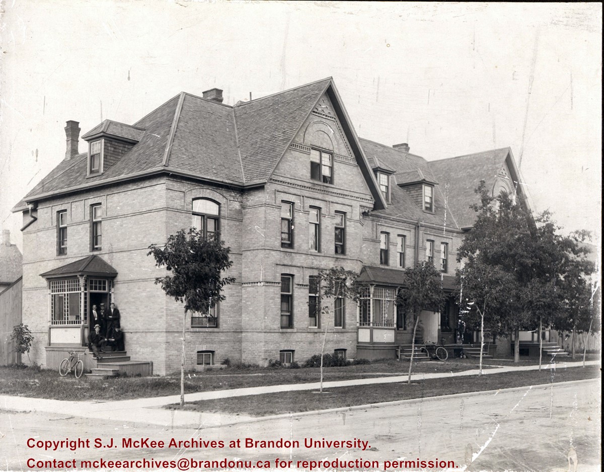
Photograph shows a three-storey multi-family brick house that appears to have at least four units. The structure also has a basement. A group of five men are posing on a stoop on the west side of the building. Sapplings have been planted on the boulevard in front the building.
Notes
Writing on the back of the photograph reads: Lorne Terrace, 12th and Lorne, always in the Hughes Family.
Postcard is bent, inked stained, and has emulsion artifacts
Scope and Content
Photograph shows a wood-framed bungalow with ornamental woodwork on the porch and roof. The home has a wooden picket fence. A woman and child are seated on one side of the ballustrade and a woman in an overcoat and hat is seated on either side of the ballustrade. Neighbouring homes are also visible.
Photograph shows a western view of the residential area along Lorne Avenue from St. Augustine's Roman Catholic Church. Roof-tops of Central School, First Baptist, Brandon College, Manitoba Power Plant, and Old City Hall are visible.
Notes
Writing on the front of the postcard reads: Lorne Avenue, looking West from St. Augustine's R.C. Church, Brandon, Man. Writing on the back of the postcard reads: The Valentine & Sons Publishing Ltd., Montreal and London, Printed in Great Britain. A cancelled George VI purple Canada 3 cent stamp has been postmarked: Brandon SP 11 52.
Postcard shows an aerial view of 9th Street facing south in Brandon, Manitoba. Visible businesses and landmarks include: Beaubier Hotel, YMCA/police station, the original CKX Radio station towers on 8th Street (est. 1928 - moved 1940), the old City Hall, Prince Edward Hotel, and the original Manitoba Power commission smokestack on 10th Street.
Notes
Writing on the front of the photograph reads: Brandon, Man., Jerrett Photo. This photograph shows a rare view of the 800-block between Rosser and Princess Avenues.
Photograph given to Fred McGuinness by Helen Turner
Scope and Content
Photograph shows a man - George Porterfield - dressed in a three-piece and hat sitting at the reins of a horse drawn buggy. The buggy appears to be parked on Lorne Avenue beside the bandstand at Stanely Park.
Notes
Note attached to the back of the photograph reads: This George Porterfield, who lived on a farm 4.9.19. Delivered eggs, cream & milk in Brandon by this method in the early 1920. Maybe he was out courting Mary, he looks pretty dressed up.
Foxing on matting and photograph, primarily along edges of photograph
Custodial History
Mona McKinnon (nee Corkish) gave photograph to Colleen McGuinness who, in turn, gave it to her father, Fred McGuinness in 2007.
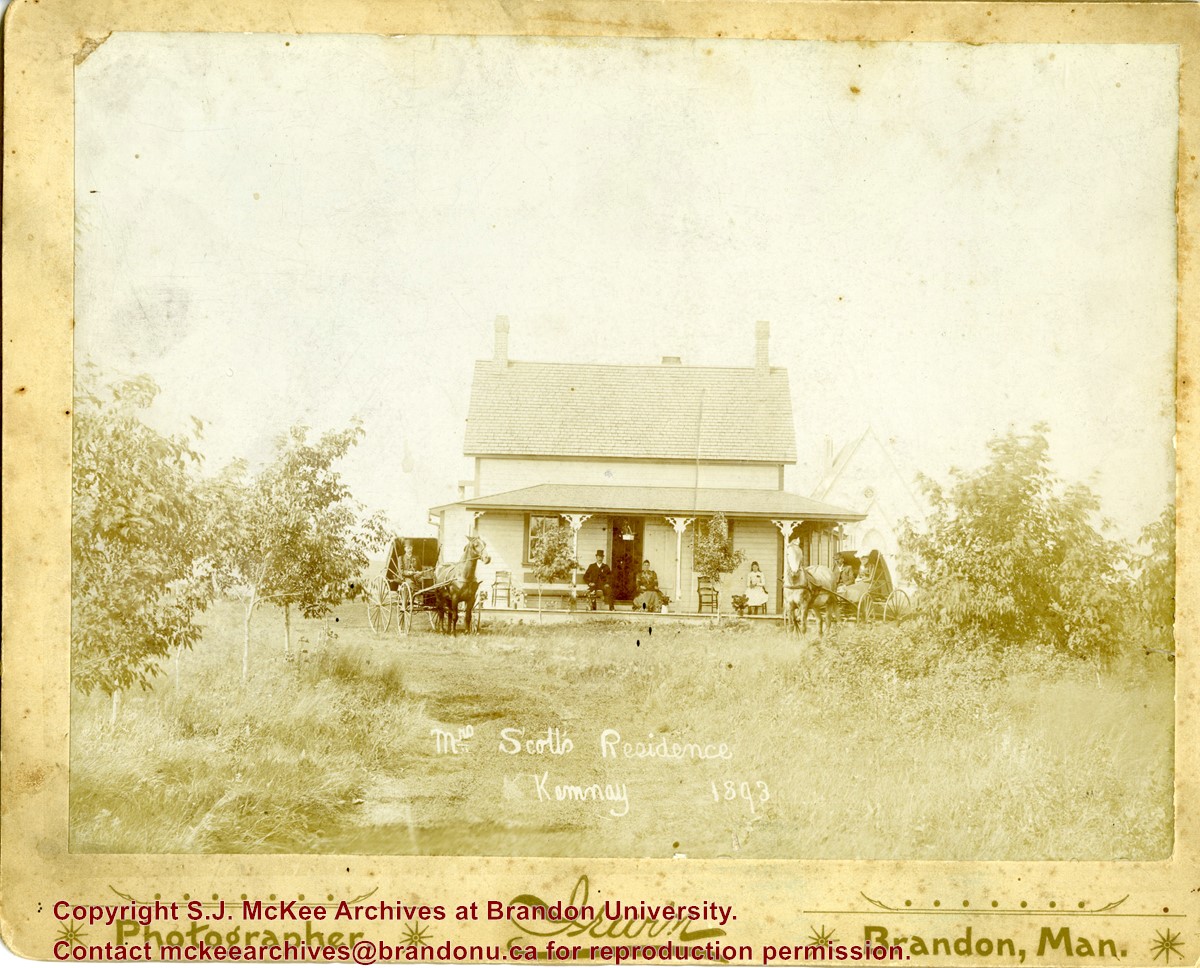
Scope and Content
Photograph shows Mrs. Scott's residence in Kemnay, Manitoba. Members of the family along with two horse-drawn buggies are clearly visible along the front of the house. A possbile church appears to the right of the house in the background.
Notes
Writing on the back of the photograph reads: Margaret Brown Scott, Mother in law to, Frank McGee Sr.
Photograph shows the exterior of the Winter Fair Arena on 10th Street.
Notes
Part of "Souvenir of Brandon, Manitoba, Canada [viewbook], Printed by Photogelatine Engraving Co. Limited, Ottawa." Dates obtained from the Burchill's Music Store Henderson's Brandon City Directory listings (1927-1929). Writing on the front of the photograph reads: Winter Fair Arena, Brandon, Man.
Photograph shows the west side of 10th Street between Rosser and Princess Avenues in the winter. Visible businesses include: Bottomley's, Simpsons-Sears, Lionel Electric, Allied Hardware Stores, Box Brothers Hardware, Doig's. Painted on the north face of the Strathcona Block are two advertisements, one for Sutherland and Robertson [Grocery] and the other for Boyd Electric Co. Ltd.
The Royal Bank moved to this location on 26 October 1929. An existing building was renovated to accomodate the bank. On 28 May 1976 fire destroyed the buildings from the lane west to the Royal Bank.
Scope and Content
Photograph shows the south side of Rosser Avenue between 7th and 8th Streets, west of the Eaton's building. Visible shops include: Vogue [Ladies Wear], Smith's Drugs, Sobie's Tailored Undergarnments, Household Finance Loans, and The Royal Bank of Canada.
See fonds level of the CKX records for custodial history.
Scope and Content
Image of the southside of the 1100 block of Rosser Avenue in winter. Visible are O.L. Harwood Ltd., the Key Kafe and Northern Auto Parts. The Perth's building, located in the 1200 block, can be seen on the righthand side in the background. A number of vehicles, a pedestrian and a man shovelling snow are also visible.
See fonds level of the CKX records for custodial history.
Scope and Content
Image of the southside of the 1000 and 1100 block of Rosser Avenue looking east in winter. Visible in the foregraound are O.L. Harwood Ltd., and the Key Kafe. Buildings in the 1000 block include: the Imperial Bank of Canada, the original Post Office and Federal Building and the original Merchants Bank. A number of pedestrians are also visible, as are Christmas decorations on the streetlights and telephone poles.
Photograph shows the 800 block of Rosser Avenue facing west. On the south side of Rosser Avenue the Nation Block, Christie's Bookstore, and Reesor's Clock can be seen. A number of horse and buggies/carriages are travelling along Rosser Avenue.


)
)