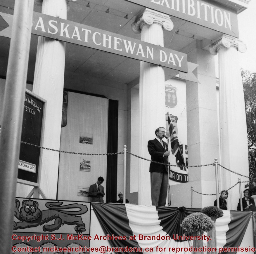
Thomas "Tommy" Clement Douglas (1904-1986) was a Baptist minister and social democratic politician. In 1935, he became a member of parliament representing the Co-operative Commonwealth Federation (CCF). From 1944 to 1961, he served as Saskatchewan's seventh premier whose CCF party introduced the universal health care program. In 1961 Douglas returned to federal politics, where he served as the leader of the New Democratic Party (NDP). He remained in federal politics until 1979.
Scope and Content
Photograph shows Saskatchewan premier Tommy Douglas at a microphone. Behind him are large ionic columns on which a "Saskatchewan Day" wooden banner is mounted. Mounted on the frieze above the columns is another sign that partially reads "National Exhibition."
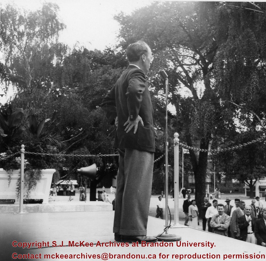
Thomas "Tommy" Clement Douglas (1904-1986) was a Baptist minister and social democratic politician. In 1935, he became a member of parliament representing the Co-operative Commonwealth Federation (CCF). From 1944 to 1961, he served as Saskatchewan's seventh premier whose CCF party introduced the universal health care program. In 1961 Douglas returned to federal politics, where he served as the leader of the New Democratic Party (NDP). He remained in federal politics until 1979.
Scope and Content
Photograph shows a close-up of Saskatchewan premier Tommy Douglas at a microphone at the Canadian National Exhibition.
Roy Rogers (1911-1998) was an American singer and cowboy actor. Rogers' career spanned radio, television, and film.
Thomas "Tommy" Clement Douglas (1904-1986) was a Baptist minister and social democratic politician. In 1935, he became a member of parliament representing the Co-operative Commonwealth Federation (CCF). From 1944 to 1961, he served as Saskatchewan's seventh premier whose CCF party introduced the universal health care program. In 1961 Douglas returned to federal politics, where he served as the leader of the New Democratic Party (NDP). He remained in federal politics until 1979.
Scope and Content
Photograph shows Tommy Douglas and Roy Rogers smiling together and holding cowboy hats.
Roy Rogers (1911-1998) was an American singer and cowboy actor. Rogers' career spanned radio, television, and film.
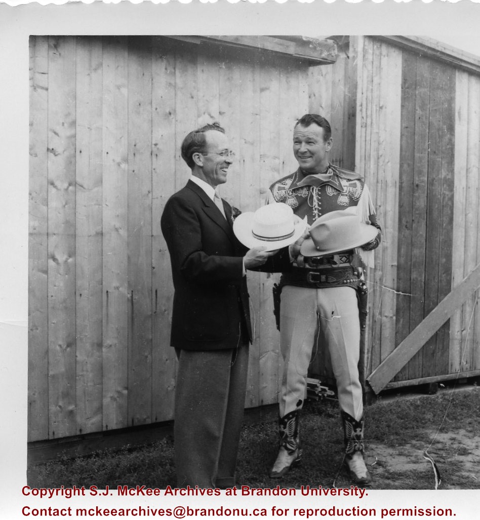
Thomas "Tommy" Clement Douglas (1904-1986) was a Baptist minister and social democratic politician. In 1935, he became a member of parliament representing the Co-operative Commonwealth Federation (CCF). From 1944 to 1961, he served as Saskatchewan's seventh premier whose CCF party introduced the universal health care program. In 1961 Douglas returned to federal politics, where he served as the leader of the New Democratic Party (NDP). He remained in federal politics until 1979.
Scope and Content
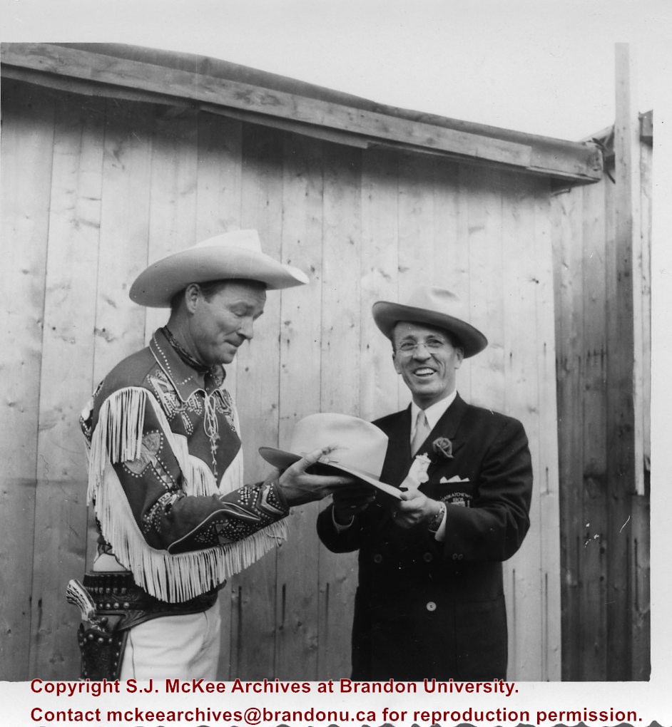
Photograph shows Tommy Douglas and Roy Rogers smiling together and wearing cowboy hats. It appears that Douglas is presenting Douglas with a new cowboy hat.
Roy Rogers (1911-1998) was an American singer and cowboy actor. Rogers' career spanned radio, television, and film.
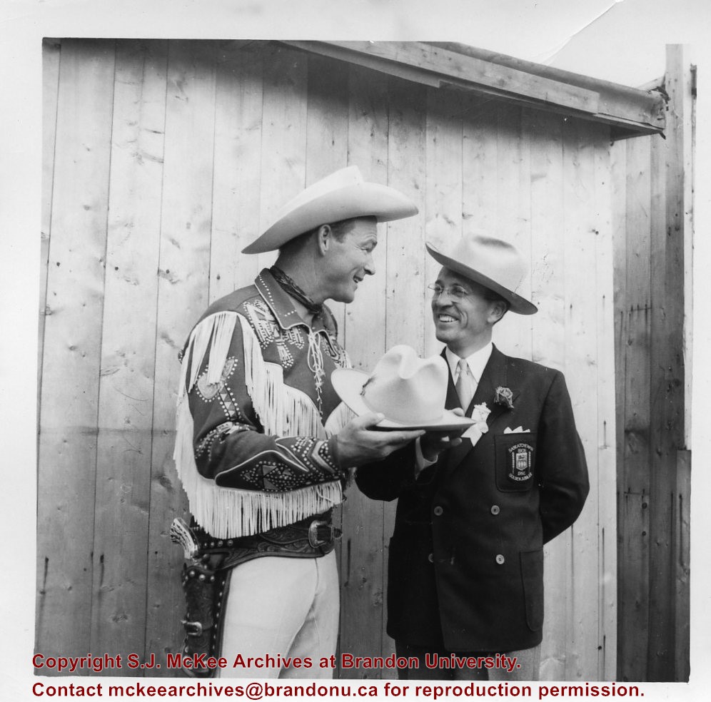
Thomas "Tommy" Clement Douglas (1904-1986) was a Baptist minister and social democratic politician. In 1935, he became a member of parliament representing the Co-operative Commonwealth Federation (CCF). From 1944 to 1961, he served as Saskatchewan's seventh premier whose CCF party introduced the universal health care program. In 1961 Douglas returned to federal politics, where he served as the leader of the New Democratic Party (NDP). He remained in federal politics until 1979.
Scope and Content
Photograph shows Tommy Douglas and Roy Rogers smiling together and wearing cowboy hats. It appears that Douglas is presenting Douglas with a new cowboy hat.
Photograph sent to Fred McGuinness from the Winnipeg Free Press Photo Department
Scope and Content
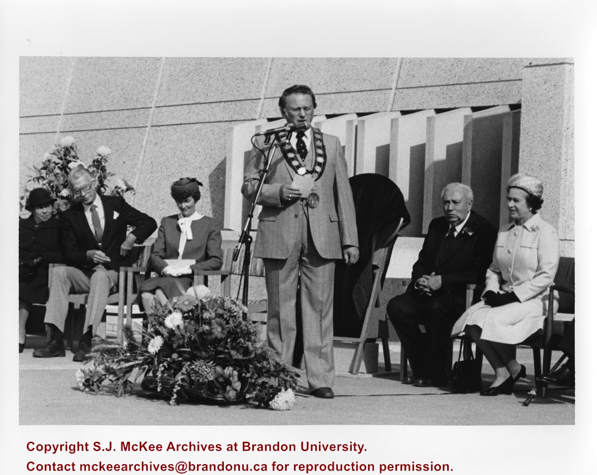
Photograph shows a platform party in front of the Westman Centennial Auditorium. At the microphone is Mayor Ken Burgess. Seated on the mayor's left is Her Majesty Queen Elizabeth II, to his right Lorne Watson. The party may have been assembled for the founding of the Brandon University School of Music's Queen Elizabeth II building.
Notes
Photograph was collected during the research phase of the monograph "Manitoba: The Province & The People" (1987) written by Fred McGuinness and Ken Coates.
Generally good. Some of the photographs have tape on them.
History / Biographical
Churches of the Prairies was a project undertaken by Doug Brolund and his brother. The project involved gathering information on the churches of the prairies (Manitoba, Saskatchewan and Alberta). They were interested in the time between 1800 to 1925. Their aim was to collect historical, architectural and photographic material, as well as information concerning the people involved in the building, the ministry and in the using of the churches. The information was to be collected, put into order and made available and retrievable to anyone wishing to use it.
The purpose of the bank of information was to be the publication of a book or books. The Brolunds' believed in the importance of preserving our heritage, of honouring those who were involved in the building of the churches and believed the material would prove to be invaluable in the future to other organizations. To gather information, they sent out letters asking for any information, photographs, news clippings and stories on the churches of the prairies. The project ended when Doug Brolund was left on his own to complete the work. He concluded that it was simply too much for one person to accomplish.
Custodial History
In the early 1980s Doug Brolund donated the text and photographs that had been assembled to the McKee Archives. He was convinced that the material was too valuable to simply discard.
Scope and Content
The collection consists of information (such as news clippings, church histories, correspondence and for Saskatchewan and Manitoba, inventory site forms) on and/or photographs of various churches across Canada. The files for Alberta; British Columbia; Ontario, Newfoundland, New Brunswick, Nova Scotia and Quebec are quite small and generally contain pages from old calendars and newsclippings, although there are a few photographs (some of them unidentified) and church histories. The Alberta file also contains a copy of the Provincial Register of Historic Sites ca. 1979.
The file for Saskatchewan contains information on and/or photographs of churches in the following towns/areas: Kennell, Castleton, McAulay, McLean, Neudorf, Eatonia, Eston, Carnduff, Wheatland and Carievale. There are also photographs of Welwyn Church, Trinity United, Florence School, Coshen? School and Wamphray Presbyterian (RM of Edenwold). The file also contains the finding aid for Saskatchewan developed by the project members.
The material on Manitoba churches is the most extensive. There is a copy of the finding aid for Manitoba developed by the project members. The files are arranged alphabetically, with separate files for Brandon, Portage la Prairie and Winnipeg. There is information on and/or photographs of churches in the following towns/areas: Aspelund Free Church, Arden, Angusville, Alexander, Birtle, Brookdale, Boissevain, Belmont, Mount Hope School District, Beulah, Beausejour, Clanwilliam, Carberry, Petral, Chater, Carrol (Bunclody), Decker, Deloraine, Dauphin, Darlingford, Douglas, Hargrave, Elgin, Elton, Elkhorn, Erickson, Forrest, Hamiota, Hunterville, Hilton, Horod, Hilltop, High Bluff, Horton (Desford), Hartney, Ingelow Isabella, Kola, Killarney, Kenton (and area), Justice, Lockport, Lenore (Breadalbane), Lynn Lake, McConnell, Minnedosa, Melita, Miniota, McGregor, Newdale, Ninga, Neepawa, Ninette, Oakner, Onla, Oakburn, Oak Lake, Pipestone, Rosser, Rapid City (and area), Rivers, Riding Mountain, Rounthwaite, Rossburn, Russell, Polonia, Sandy Lake, Scandinavia, Solsgirth, Souris, Hellmouth, Seech (and area), The Pas, Saint Agathe, St. Pierre, St. Anne, Teulon, St. Andrews-on-the-Red, Swan River, Shilo, Sparling, Virden, Westnbourne, Vista, Wabowden, Wawanesa, Waskade, Brandon, Brandon Hills, Portage la Prairie, Portage la Prairie (Oakland) and Winnipeg.
File 24 contains negatives. There are also some negatives for New Brunswick churches in File 23.
Notes
The Brandon file also contains a minute book of the First Church United Circle. For information on the Brandon Synagogue, see the Brandon Synagogue file in the institutional biographies. For technical architectural descriptions of some Brandon Churches, see "A Guide to the City of Brandon, Municipal Heritage Building Inventory" in the institutional biography files. The Winnipeg file contains a copy of "Souris Valley Plains - a history" by Lawrence B. Clarke. A number of the Winnipeg churches are unidentified. Description by Christy Henry.
James Douglas Wall was born in Brandon, Manitoba on March 22, 1933, the only son of James Jesse Wall and Audrey May Simm. James Wall grew up in Brandon, attending public schools in the city and graduating from Brandon Collegiate Institute. At an early age, he became a member of the 82nd Squadron Royal Canadian Air Cadets. In the summer of 1950, he earned his pilot's wings through the Air Cadets Scholarship Program. Wall has been employed with the Brandon Flying Club and has earned a commercial pilot's licence and an aircraft maintenance engineer's licence. In 1957, he became manager of Maple Leaf Aviation Limited. Wall is a long time member of the South West branch of the Manitoba Genealogical Society, Inc. of which he has served as president for several terms. Wall has been married to his wife Elizabeth since 1957. They have one son, David. James Douglas Wall died in Brandon, Manitoba on February 11, 2011.
Custodial History
These items were acquired by Wall in his capacity as President of the Southwest Branch of the Manitoba Genealogical Society. Custodial history prior to their acquisition by Wall and his donation of them to the S.J. McKee Archives is unknown.
Scope and Content
Collection contains 35 photographs of Baldur, Manitoba taken ca. 1900. These photographs contain images of buildings, street scenes, and residents (individuals and groups) of Baldur, Manitoba. Collection also includes a copy of Christie's Map of the City of Brandon ca. 1900.
The Douglas Women's Institute was established in 1948. Throughout its existence, the Institute undertook a variety of community based fund raising and educational activities, including the sponsorship of courses in first-aid, home nursing and sewing. The Douglas WI also provided a public space for women in the Douglas district to meet and engage in educational, social and political activities.
Custodial History
The records were in the possession of officers of the Douglas Women's Institute prior to their donation to the S.J. McKee Archives in April 2006 and May 2008, following the disbandment of the organization.
Scope and Content
Fonds consists of scrapbooks and Annual Programs assembled by members of the Douglas Women's Institute. Fonds also contain clippings related to local, provincial, national and international themes of interest to the members of the Institute. The scrapbooks are particularly strong on community stories directly connected to the Douglas Women's Institute and the Douglas-Carberry district including anniversaries, biographical sketches, obituaries, weddings and family related themes.
Notes
Description by Christy Henry.
Storage Location
2006 accessions, 2008 accessions
Related Material
Related women's institute collections in the McKee Archives include:
Manitoba Women's Institute; Minnedosa Women's Institute; Cordova Women's Institute; Clanwilliam Women's Institute; Rathwell Women's Institute; Strathclair Women's Institute; Crocus Women's Institute; Southwest A Region - Manitoba Women's Institute; Douglas Women's Institute
Copy of the Japanese National Hymn arranged for the pianoforte by Sydney Osborne. Also includes the music for Kathleen Mavourneen arranged for piano by Percy E. Douglas and Donau Wellen by I. Ivanovici, easily arranged by Percy E. Douglas.
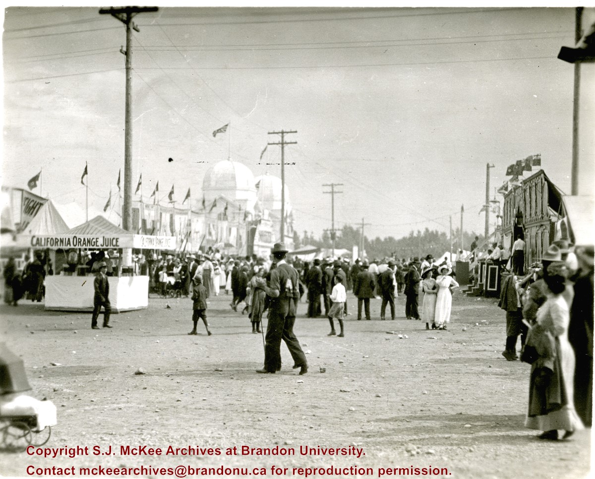
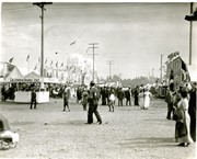
Photograph shows the midway at the 1913 Dominion Fair. Attractions include California Orange Juice stand and Patterson's Animal Trainer Show. The Dominion Exhibition Display Building II can be seen in the background.
Notes
Photograph appears to be a part of a sequence of photographs, see 20-2009.30 to 20-2009.40
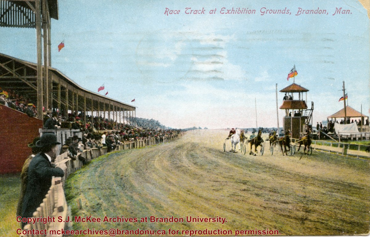
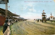
Postcard shows the grandstand and race track located at the Exhibition Grounds (now the site of the Keystone Centre/Westman Communications Place) in the south end of Brandon, Manitoba. The bleachers are filled with people and spectators also line the fence alongside the track. Five harness racers are making their way along the track. An observation tower and possible gazebo for dignitaries is located inside the track.
Notes
The back of the postcard is address to Mrs. Sharpe of Banff, Alberta. A green King George One Cent stamp has been postmarked Sault Ste. Maire, Ont., July 6, 1910. The message reads: Lake Superior, My dear. How are you? Glad you are charmed with B. don't get too fat. Tell Mrs. Coates my state room companion is Miss Rutherford of B. Coll: she got on at Port Arthur. Having a lovely trip. It was hard parting at B. .......Address 14 Deer Park, Toronto. Postcard manufactured by Stedman Bros. Ltd., Brantford, Canada. S.B. 2376. Made in Germany.
These records were produced between 1984 and 1985, the researching and writing period for the book The Pride of the Land: An Affectionate History of Brandon’s Agricultural Exhibition. Published in 1985 by Peguis Books (Winnipeg), Pride of the Land is a 222-page soft cover book, containing hundreds of pictures, and 50,000 words of text.
BU faculty members Dr. Kenneth “Ken” Stephen Coates, Assistant Professor of History, and Mr. Fred McGuinness, Lecturer in Journalism, authored the book. Assisting the writers was a research team of four BU history students, which were referred to as “The Pride Team”: Diane Fowler, Rob McGarva, Bruce Stafeld, and Byron Williams.
The Pride Team was tasked with collecting and synthesizing exhibition documents and other materials in city, provincial, and federal records spanning 100 years. Many local newspapers and committee minutes were consulted.
The authors cover 103 years of Brandon Fair history, starting with the first fair in 1882 followed by the development of other agricultural fairs and exhibitions in Brandon, specifically The Royal Manitoba Winter Fair, The Provincial Exhibition of Manitoba, and the Ag-Ex livestock show.
Custodial History
Records were collected and created by McGuinness, Coates, and The Pride Research Team during the process of the creation of the book, The Pride of the Land: An Affectionate History of Brandon’s Agricultural Exhibition. The materials were donated to the SJ McKee Archives by the authors circa 1988. The Archives accessioned the records in 2008.
Scope and Content
The subseries consists of textual records, created and collected during the production of the monograph Pride of the Land. It includes research cards created by the research team, copies of newspaper articles from very early editions of Brandon newspapers (such as the Brandon Sun, Brandon Daily Sun, Western Sun, and The Independent), copies of fair/organizational minutes, photocopies of photographs used in the publication, and chapter drafts. Of particular interest are the detailed summaries of Provincial Exhibition minutes that were specifically produced for each book chapter.
Notes
Information in the history/biography was taken from a Brandon University press release dated June 1985, about the Pride of the Land Project (see file 64)
Description Note: The original accession number is noted on the front of each file folder. The circled number indicates the original file order in the 6-2008 accession
Accruals
Closed
Language Note
Fred McGuinness often uses journalistic jargon to label his files. A “brite” refers to a short, amusing story
Pride of the Land acronyms:
PEM = Provincial Exhibition Association of Manitoba
RCMP = Royal Canadian Mounted Police
WAAA = Western Agricultural & Arts Association
Finding Aid
A file level inventory is available
Storage Location
2015 accessions
Related Material
Provincial Exhibition Association of Manitoba fonds
Arrangement
Arrangement was artificially created by the Archives. Subseries has been arranged according to book chapter. McGuinness often organized his ideas and research materials by potential brite topic
The Medicine Hat Exhibition and Stampede Parade Day was held on Thursday, July 19, 1962, at 9:30 a.m. The local newspaper reported that approximately 24,000 people were in attendance to see parade marshall Rod Ashburner leading 175 entries consisting of 90 floats, 75 horses, and 10 bands. There were 19 parade categories eligible for $12,000 in prize money and included: junior and senior cowboys and cowgirls; fancy and Shetland ponies; sulky class open; comic, commercial, industrial and organizational floats; decorated cars; special ranch class; 4-H Clubs; and a non-competitive class.
The parade route started at Second St. and Allowance Ave., from Second St. to Ash Ave., north on Ash to First St. SE., from First St. S.E. to Fourth Ave., south to Second St. to South Railway St., south on South Railway St. to Third St., with a finish at McLeod Trail. A route map was published in the Medicine Hat News the day before the parade.
Aerial photographs of the parade were taken by Medicine Hat News photographer Howard Heid (1930-2005) from the private helicopter of John Bourn. Bourn was a pilot from Woodville, Wisconsin, who chartered his four-seater helicopter for sight-seers at exhibitions and stampedes across the county.
(Sources: Pat Currie, "Let 'Er Go!," Medicine Hat News, 19 July 1962,1; Harald Gunderson, "'Eye in the Sky' Best Parade View," Medicine Hat News, 19 July 1962,1; "Parade Starts at 9:30 Sharp," 18 July 1962)
Scope and Content
Photograph shows an aerial view of the Medicine Hat Exhibition and Stampede Parade route, with a focus on Second Street SE. A residential area showing homes with extensive backyard gardens can be seen. The South Saskatchewan River can be see on the right of the photograph.
Notes
This photograph shows the neighbourhood before rezoning and commercial development.
The Medicine Hat Exhibition and Stampede Parade Day was held on Thursday, July 19, 1962, at 9:30 a.m. The local newspaper reported that approximately 24,000 people were in attendance to see parade marshall Rod Ashburner leading 175 entries consisting of 90 floats, 75 horses, and 10 bands. There were 19 parade categories eligible for $12,000 in prize money and included: junior and senior cowboys and cowgirls; fancy and Shetland ponies; sulky class open; comic, commercial, industrial and organizational floats; decorated cars; special ranch class; 4-H Clubs; and a non-competitive class.
The parade route started at Second St. and Allowance Ave., from Second St. to Ash Ave., north on Ash to First St. SE., from First St. S.E. to Fourth Ave., south to Second St. to South Railway St., south on South Railway St. to Third St., with a finish at McLeod Trail. A route map was published in the Medicine Hat News the day before the parade.
Aerial photographs of the parade were taken by Medicine Hat News photographer Howard Heid (1930-2005) from the private helicopter of John Bourn. Bourn was a pilot from Woodville, Wisconsin, who chartered his four-seater helicopter for sight-seers at exhibitions and stampedes across the county.
(Sources: Pat Currie, "Let 'Er Go!," Medicine Hat News, 19 July 1962,1; Harald Gunderson, "'Eye in the Sky' Best Parade View," Medicine Hat News, 19 July 1962,1; "Parade Starts at 9:30 Sharp," 18 July 1962)
Scope and Content
Photograph shows an aerial view of the Medicine Hat Exhibition and Stampede Parade route, with a focus on Second Street SE. Visible store signs include: China Wonderland, Grey Cup Cafe, Lane Bros. & Gibson Ltd., Joy's, Marshall's, Monarch, Gardener's Used Cars, Provincial Treasury Branch, Furvey's Furniture and Appliances, J.J. Moore & Son, Club Cafe, Black Hardware Ltd., Regency Billards, and Sair's Shoe Hospital.
The Medicine Hat Exhibition and Stampede Parade Day was held on Thursday, July 19, 1962, at 9:30 a.m. The local newspaper reported that approximately 24,000 people were in attendance to see parade marshall Rod Ashburner leading 175 entries consisting of 90 floats, 75 horses, and 10 bands. There were 19 parade categories eligible for $12,000 in prize money and included: junior and senior cowboys and cowgirls; fancy and Shetland ponies; sulky class open; comic, commercial, industrial and organizational floats; decorated cars; special ranch class; 4-H Clubs; and a non-competitive class.
The parade route started at Second St. and Allowance Ave., from Second St. to Ash Ave., north on Ash to First St. SE., from First St. S.E. to Fourth Ave., south to Second St. to South Railway St., south on South Railway St. to Third St., with a finish at McLeod Trail. A route map was published in the Medicine Hat News the day before the parade.
Aerial photographs of the parade were taken by Medicine Hat News photographer Howard Heid (1930-2005) from the private helicopter of John Bourn. Bourn was a pilot from Woodville, Wisconsin, who chartered his four-seater helicopter for sight-seers at exhibitions and stampedes across the county.
(Sources: Pat Currie, "Let 'Er Go!," Medicine Hat News, 19 July 1962,1; Harald Gunderson, "'Eye in the Sky' Best Parade View," Medicine Hat News, 19 July 1962,1; "Parade Starts at 9:30 Sharp," 18 July 1962)
Scope and Content
Photograph shows an aerial view of the Medicine Hat Exhibition and Stampede Parade route, with a focus on the First Street SE and North Railway Street merge.
Notes
This photograph appeared on the front page of The Medicine Hat News (19 July 1962).
The Medicine Hat Exhibition and Stampede Parade Day was held on Thursday, July 19, 1962, at 9:30 a.m. The local newspaper reported that approximately 24,000 people were in attendance to see parade marshall Rod Ashburner leading 175 entries consisting of 90 floats, 75 horses, and 10 bands. There were 19 parade categories eligible for $12,000 in prize money and included: junior and senior cowboys and cowgirls; fancy and Shetland ponies; sulky class open; comic, commercial, industrial and organizational floats; decorated cars; special ranch class; 4-H Clubs; and a non-competitive class.
The parade route started at Second St. and Allowance Ave., from Second St. to Ash Ave., north on Ash to First St. SE., from First St. S.E. to Fourth Ave., south to Second St. to South Railway St., south on South Railway St. to Third St., with a finish at McLeod Trail. A route map was published in the Medicine Hat News the day before the parade.
Aerial photographs of the parade were taken by Medicine Hat News photographer Howard Heid (1930-2005) from the private helicopter of John Bourn. Bourn was a pilot from Woodville, Wisconsin, who chartered his four-seater helicopter for sight-seers at exhibitions and stampedes across the county.
(Sources: Pat Currie, "Let 'Er Go!," Medicine Hat News, 19 July 1962,1; Harald Gunderson, "'Eye in the Sky' Best Parade View," Medicine Hat News, 19 July 1962,1; "Parade Starts at 9:30 Sharp," 18 July 1962)
Scope and Content
Photograph shows an aerial view of the Medicine Hat Exhibition and Stampede Parade route with a focus on the First Street SE. A number of gas stations and garages are visible along this route and include Texaco, Shell, Ford, and B/A. The Fraternal Order of Eagles lodge is also visible.
Notes
This photograph appeared on the front page of The Medicine Hat News (19 July 1962).
The Medicine Hat Exhibition and Stampede Parade Day was held on Thursday, July 19, 1962, at 9:30 a.m. The local newspaper reported that approximately 24,000 people were in attendance to see parade marshall Rod Ashburner leading 175 entries consisting of 90 floats, 75 horses, and 10 bands. There were 19 parade categories eligible for $12,000 in prize money and included: junior and senior cowboys and cowgirls; fancy and Shetland ponies; sulky class open; comic, commercial, industrial and organizational floats; decorated cars; special ranch class; 4-H Clubs; and a non-competitive class.
The parade route started at Second St. and Allowance Ave., from Second St. to Ash Ave., north on Ash to First St. SE., from First St. S.E. to Fourth Ave., south to Second St. to South Railway St., south on South Railway St. to Third St., with a finish at McLeod Trail. A route map was published in the Medicine Hat News the day before the parade.
Aerial photographs of the parade were taken by Medicine Hat News photographer Howard Heid (1930-2005) from the private helicopter of John Bourn. Bourn was a pilot from Woodville, Wisconsin, who chartered his four-seater helicopter for sight-seers at exhibitions and stampedes across the county.
(Sources: Pat Currie, "Let 'Er Go!," Medicine Hat News, 19 July 1962,1; Harald Gunderson, "'Eye in the Sky' Best Parade View," Medicine Hat News, 19 July 1962,1; "Parade Starts at 9:30 Sharp," 18 July 1962)
Scope and Content
Photograph shows an aerial view of the Medicine Hat Exhibition and Stampede Parade route with a focus on the First Street SE and Ash Street. A residential area showing homes with extensive backyard gardens can be seen.
Notes
This photograph shows the neighbourhood before rezoning and commercial development.
The Medicine Hat Exhibition and Stampede Parade Day was held on Thursday, July 19, 1962, at 9:30 a.m. The local newspaper reported that approximately 24,000 people were in attendance to see parade marshall Rod Ashburner leading 175 entries consisting of 90 floats, 75 horses, and 10 bands. There were 19 parade categories eligible for $12,000 in prize money and included: junior and senior cowboys and cowgirls; fancy and Shetland ponies; sulky class open; comic, commercial, industrial and organizational floats; decorated cars; special ranch class; 4-H Clubs; and a non-competitive class.
The parade route started at Second St. and Allowance Ave., from Second St. to Ash Ave., north on Ash to First St. SE., from First St. S.E. to Fourth Ave., south to Second St. to South Railway St., south on South Railway St. to Third St., with a finish at McLeod Trail. A route map was published in the Medicine Hat News the day before the parade.
Aerial photographs of the parade were taken by Medicine Hat News photographer Howard Heid (1930-2005) from the private helicopter of John Bourn. Bourn was a pilot from Woodville, Wisconsin, who chartered his four-seater helicopter for sight-seers at exhibitions and stampedes across the county.
(Sources: Pat Currie, "Let 'Er Go!," Medicine Hat News, 19 July 1962,1; Harald Gunderson, "'Eye in the Sky' Best Parade View," Medicine Hat News, 19 July 1962,1; "Parade Starts at 9:30 Sharp," 18 July 1962)
Scope and Content
Photograph shows an aerial view of the Medicine Hat Exhibition and Stampede Parade route with a focus on the First Street SE and and the South Railway Street merge. A number of gas stations and garages are visible along this route and include Texaco, Shell, Ford, and B/A. The Fraternal Order of Eagles lodge is also visible.
Notes
This photograph shows the neighbourhood before rezoning and commercial development.


