Skip header and navigation

Revise Search

20 records – page 1 of 1.

Horse and buggies travelling east on Rosser Avenue

http://archives.brandonu.ca/en/permalink/descriptions13769
Part Of
Fred McGuinness collection
Description Level
Item
GMD
graphic
Date Range
[1906]
Accession Number
20-2009
Part Of
Fred McGuinness collection
Description Level
Item
Series Number
McG 9
Item Number
20-2009.80
Accession Number
20-2009
GMD
graphic
Date Range
[1906]
Physical Description
6.5" x 4.25" (b/w)
Material Details
on matting
Physical Condition
Photographs have been glued to a backing board that has warped over time
History / Biographical
Photograph of possible Dakota from Sioux Valley in Brandon for the summer fair.
Scope and Content
Photograph shows street view of north side of Rosser Avenue, primarily the 700 block. Businesses visible in the Beaubier Block include the Empire Hotel. Businesses east of the Empire Hotel are grocer A.M. Percival, the Brandon Hardware Company, and the Arlington Hotel. A number of Aboriginal peoples are driving horse and buggies east along Rosser Avenue as large numbers of spectators look on.
Notes
Writing on the front of the photograph matting reads: 298. One photograph (20-2009.79) is glued above, another (20-2009.81) adjacent. One other is glued on the reverse side. Page appears to be from a photo album.
Name Access
Empire Hotel
D.W. Beaubier Block
A.M. Percival
Brandon Hardware Company
Rosser Avenue
Subject Access
Street scene
Transportation
downtown
grocers
storefronts
dogs
Aboriginals
First Nations
horses
buggies
Storage Location
RG 5 photograph storage drawer 2 (hanging photos)
Images
Show Less

George and Mary Porterfield

http://archives.brandonu.ca/en/permalink/descriptions14008
Part Of
Fred McGuinness collection
Description Level
Item
GMD
graphic
Date Range
[1920s]
Accession Number
1-2015
Part Of
Fred McGuinness collection
Description Level
Item
Series Number
McG 9
Item Number
1-2015.78
Accession Number
1-2015
GMD
graphic
Date Range
[1920s]
Physical Description
5.5" x 3.25" (b/w)
Custodial History
Photograph given to Fred McGuinness by Helen Turner
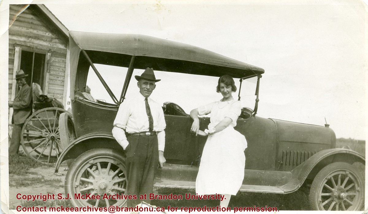
Scope and Content
Photograph shows a man - George Porterfield - and woman - Mary Porterfield - posing with a vehicle on a farm property.
Notes
Writing on the back of the photograph reads: Taken in the Summer at one of the neighbour homes George & myself. Note attached to the back of the photograph reads: George & Mary got married on June 6th 1923 and lived on the farm. This is their first car.
Name Access
George Porterfield
Subject Access
Transportation
automobiles
motor cars
farms
rural life
Storage Location
RG 5 photograph storage drawer 2 (hanging photos)
Arrangement
McG 1.2 file 20
Images
Show Less

Horse and buggies travelling on Rosser Avenue

http://archives.brandonu.ca/en/permalink/descriptions13699
Part Of
Fred McGuinness collection
Description Level
Item
GMD
graphic
Date Range
[1906]
Accession Number
20-2009
Part Of
Fred McGuinness collection
Description Level
Item
Series Number
McG 9
Item Number
20-2009.9
Accession Number
20-2009
GMD
graphic
Date Range
[1906]
Physical Description
6.5" x 4.25" (b/w)
Material Details
on matting
Physical Condition
Photographs have been glued to a backing board that has warped over time
History / Biographical
Photograph of possible Dakota from Sioux Valley in Brandon for the summer fair.
Scope and Content
Photograph shows street view of north side of Rosser Avenue, primarily the 700 block. Businesses visible in the Fleming Block include: Lowes Brothers Clothing, Robert Hall [Insurance Broker], Manitoba Farmers Hedge and Wire Fence Company. Businesses visible in the Beaubier Block include the Empire Hotel. Businesses east of the Empire Hotel are grocer A.M. Percival and the Brandon Hardware Company. A number of Aboriginal peoples are driving horse and buggies west along Rosser Avenue as spectators look on.
Notes
Writing on the front of the photograph matting reads: 294 July 1906. One photograph (20-2009.10) is glued below and two others are glued on the reverse side. Page appears to be from a photo album.
Name Access
Fleming Block
Lowes Brothers Clothing
Manitoba Farmers Hedge and Wire Fence Company
Empire Hotel
D.W. Beaubier Block
A.M. Percival
Brandon Hardware Company
Rosser Avenue
Subject Access
Street scene
Transportation
downtown
grocers
storefronts
dogs
Aboriginals
First Nations
horses
buggies
insurance agents
Storage Location
RG 5 photograph storage drawer 2 (hanging photos)
Images
Show Less

Intersection of Rosser Avenue and 8th Street facing west

http://archives.brandonu.ca/en/permalink/descriptions13786
Part Of
Fred McGuinness collection
Description Level
Item
GMD
graphic
Date Range
[19--]
Accession Number
20-2009
Part Of
Fred McGuinness collection
Creator
Photographer: Brandon Sun
Description Level
Item
Series Number
McG 9
Item Number
20-2009.97
Accession Number
20-2009
GMD
graphic
Date Range
[19--]
Physical Description
8.5" x 5.25" (b/w)
Material Details
reproduction
Scope and Content
Photograph shows the 800 block of Rosser Avenue facing west. On the south side of Rosser Avenue the Nation Block, Christie's Bookstore, and Reesor's Clock can be seen. A number of horse and buggies/carriages are travelling along Rosser Avenue.
Name Access
Rosser Avenue
Reesor’s Jewellery
Reesor's clock
Subject Access
downtown
street scenes
Brandon Street Scenes Before 1940
Transportation
horses
buggies
Storage Location
RG 5 photograph storage drawer 2 (hanging photos)
Images
Show Less
Part Of
RG 11 Lawrence Stuckey fonds
Description Level
Item
GMD
graphic
Date Range
[18-?]
Accession Number
1-2002
Part Of
RG 11 Lawrence Stuckey fonds
Description Level
Item
Series Number
3.1
Item Number
1-2002.3.1L4
Accession Number
1-2002
GMD
graphic
Date Range
[18-?]
Physical Description
3 1/2" x 5"
Material Details
Negative
Custodial History
For custodial history see the collection level description of the Lawrence Stuckey collection.
Scope and Content
Horse & buggy
Name Access
Horse & Buggy
Subject Access
Transportation
Livestock
horses
Brandon Transportation (other than rail)
Repro Restriction
The McKee Archives is the copyright holder for the Stuckey materials.
Storage Location
Lawrence Stuckey collection
Images
Show Less

Street scene Rosser Avenue and 8th Street intersection

http://archives.brandonu.ca/en/permalink/descriptions13705
Part Of
Fred McGuinness collection
Description Level
Item
GMD
graphic
Date Range
1906
Accession Number
20-2009
Part Of
Fred McGuinness collection
Description Level
Item
Series Number
McG 9
Item Number
20-2009.15
Accession Number
20-2009
GMD
graphic
Date Range
1906
Physical Description
6.5" x 4.25" (b/w)
Material Details
on matting
Physical Condition
Photographs have been glued to a backing board that has warped over time
Scope and Content
Photograph shows street view of north side of Rosser Avenue, primarily the 700 block. The Fleming Block, Beaubier Block and its Empire Hotel, A.M. Percival (a grocer), the Brandon Hardware Company (600 block), and the Arlington Hotel (500 block) are visible along the north side of the avenue. The Bank of Hamilton Building on the southeast corner of 8th Street and Rosser appears to be under construction. A sign in the second storey window above the main entrance reads: law office. The streets are muddy and a horse and buggy is traveling west on Rosser Avenue.
Notes
Writing on the front of the photograph matting reads: mud November 12, 1906, 339. The photograph appears to be taken from the interior of a builing on the southwest corner of 8th Street and Rosser Avenue. Page appears to be from a photo album.
Name Access
Fleming Block
Empire Hotel
D.W. Beaubier Block
A.M. Percival
Brandon Hardware Company
Rosser Avenue
Subject Access
Street scene
Transportation
downtown
grocers
storefronts
mud
dogs
horses
buggies
insurance agents
lawyers
Storage Location
RG 5 photograph storage drawer 2 (hanging photos)
Images
Show Less

International Peace Garden grand opening 1932

http://archives.brandonu.ca/en/permalink/descriptions13776
Part Of
Fred McGuinness collection
Description Level
Item
GMD
graphic
Date Range
1932
Accession Number
20-2009
Part Of
Fred McGuinness collection
Description Level
Item
Series Number
McG 9
Item Number
20-2009.87
Accession Number
20-2009
GMD
graphic
Date Range
1932
Physical Description
5.75" x 3.5" (b/w)
History / Biographical
The International Peace Garden is situated on the international border between Manitoba and North Dakota, adjacent to the Canadian Border Services Boissevain port of entry and the U.S. Customs and Border Protection Agency's Dunseith port of entry. The dedication for the International Peace Garden was held on July 14, 1932. It was estimated that 50,000 people were in attendance on opening day. The park is 9.5-square kilometers or 3.54-square miles.
Custodial History
Pictures were sent to Fred McGuinness in 1970 from E.M. Bergson of Brandon.
Scope and Content
Photograph shows the crowded parking lot at the International Peace Garden's 1932 dedication ceremony. People mill amongst the automobiles and tents can be seen in the background.
Notes
The back of the photograph is stamped: Enameloid Velox Print by the Jul 27 1932, Chicago Postal Photo Supplies, Regina, Sask.
Name Access
International Peace Garden
North Dakota
Subject Access
gardens
parks
Transportation
automobiles
Storage Location
RG 5 photograph storage drawer 2 (hanging photos)
Images
Show Less

8th Street and Rosser Avenue intersection

http://archives.brandonu.ca/en/permalink/descriptions13768
Part Of
Fred McGuinness collection
Description Level
Item
GMD
graphic
Date Range
[1906]
Accession Number
20-2009
Part Of
Fred McGuinness collection
Description Level
Item
Series Number
McG 9
Item Number
20-2009.79
Accession Number
20-2009
GMD
graphic
Date Range
[1906]
Physical Description
4.25" x 3.25" (b/w)
Material Details
on matting
Physical Condition
Photograph is scratched and has been glued to a backing board that has warped over time
Scope and Content
Photograph shows street view of the northeast intersection of the 000 block of 8th Street and Rosser Avenue. Horse and buggies are parked along the east side of 8th Street. Businesses on the east side of 8th Street from Pacific to Rosser Avenues are clearly visible and include: a Lunch Room (likely Aagaard's Lunch Counter), the Hotel Imperial Annex, Liverpool House (a boarding house), R.S. Thompson and Company Real Estate Office (Land Office), a barber shop (likely J. Coulter's), Frank Gowen photography studio, and Fleming's Drug Store. A possible street fair is in progress on Rosser Avenue. One man is standing on a soap box and is surrounded by a crowd in the middle of 8th Street. Another man can be seen standing behind a booth on the northwest street corner. Building construction appears to be happening on the west corner of 8th Street and Rosser Avenue.
Notes
Writing on the front of the photograph matting reads: 297. One photograph (20-2009.80) is glued below the photograph. Another photograph is glued on the reverse side. Page appears to be from a photo album.
Name Access
Fleming Block
Fleming's Drug Store
Frank Gowen Photographer
Liverpool House
Hotel Imperial Annex
8th Street
Rosser Avenue
Aagaard's
R.S. Thompson
8th Street Bridge
Subject Access
Street scene
Transportation
downtown
storefronts
store exteriors
hotels
boarding houses
barber shops
restaurants
druggists
photographers
bridge
horses
dogs
buggies
Storage Location
RG 5 photograph storage drawer 2 (hanging photos)
Images
Show Less

Donald Street looking south from Portage Avenue, Winnipeg

http://archives.brandonu.ca/en/permalink/descriptions14055
Part Of
Fred McGuinness collection
Description Level
Item
GMD
graphic
Date Range
1927
Accession Number
1-2015
Part Of
Fred McGuinness collection
Creator
Printer: Valentine
Description Level
Item
Series Number
McG 9
Item Number
1-2015.125
Accession Number
1-2015
GMD
graphic
Date Range
1927
Physical Description
3.5" x 5.5" (colour)
Material Details
postcard
Scope and Content
Postcard shows a street scene of Donald Street looking south from the Portage Avenue Intersection.
Notes
Writing on the back of the postcard reads: Aug 9, Dear ruth, Aunt Eva, Aunt Annie and Fred were over to the bowlnig greens tonight. Every one fine. Doddy. Postcard is addressed to Ruth McGuinness, 337-17th St., Brandon, Man. Postmarked: Winnipeg 12 PM Aug 10 1927 Man.
Name Access
Winnipeg
Subject Access
street scenes
street cars
streetcars
Transportation
Storage Location
RG 5 photograph storage drawer 2 (hanging photos)
Arrangement
McG 1.1 file 17
Images
Show Less
Part Of
Fred McGuinness collection
Description Level
Item
GMD
graphic
Date Range
[1940s]
Accession Number
1-2015
Part Of
Fred McGuinness collection
Creator
Printer: Jerrett, Brandon
Description Level
Item
Series Number
McG 9
Item Number
1-2015.126
Accession Number
1-2015
GMD
graphic
Date Range
[1940s]
Physical Description
5.5" x 3.5" (b/w)
Material Details
postcard
Scope and Content
Postcard shows a man and woman seated on a couch while holding two babies. The man is wearing a clerical collar.
Notes
Photograph possibly of Mary Charlotte Oldfield (nee McGuinness) with Rev. Henry John Herbert Oldfield and John William Frederick "Fred"
Name Access
Winnipeg
Subject Access
street scenes
street cars
streetcars
Transportation
Storage Location
RG 5 photograph storage drawer 2 (hanging photos)
Arrangement
RR #6 (red folder)
Images
Show Less
Part Of
Fred McGuinness collection
Description Level
Item
GMD
graphic
Date Range
1980s
Accession Number
20-2009
Part Of
Fred McGuinness collection
Description Level
Item
Series Number
McG 9
Item Number
20-2009.109
Accession Number
20-2009
GMD
graphic
Date Range
1980s
Physical Description
4.5" x 6" (b/w)
Material Details
reproduction
History / Biographical
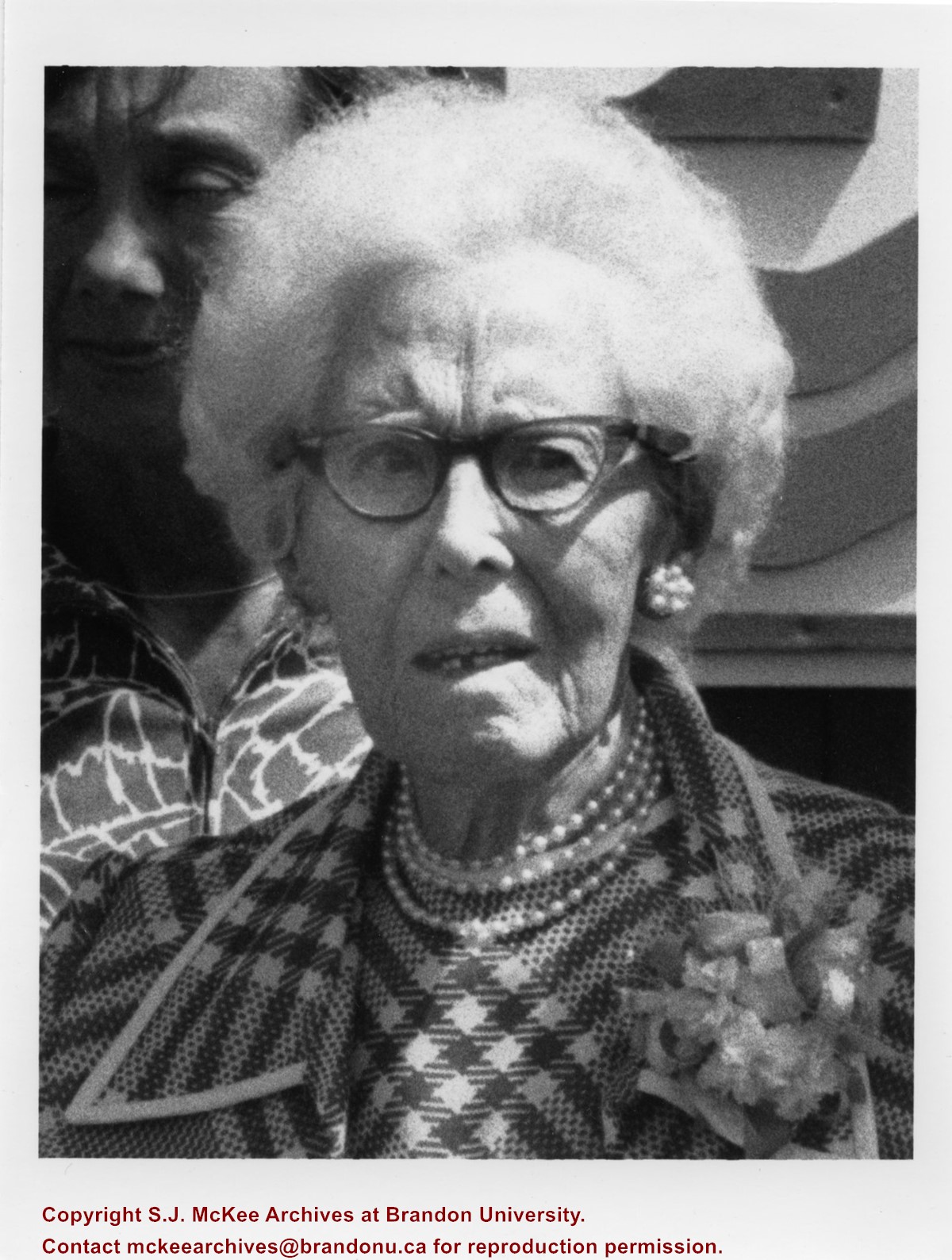
Eleanor Kidd Park (est. 1977) is situated on 18th Street North, on the south side of the Assiniboine River, and east of the Thompson twinned bridge. The park was the former site of an animal shelter overseen by Eleanor Kidd. Adjacent to the park are the Eleanor Kidd Gardens, which contains performance and fountain plazas. The sites have been subjected to heavy flooding from 2011 to 2015. Eleanor Maud Kidd (nee Death) (b.05 Aug 1881, d. 11 July 1978) was born in London, England. She trained as a nurse/midwife at the Liverpool Children's Hospital and worked as a private nurse for affluent families in Italy. She immigrated to Canada in 1913 and lived in Portage la Prairie where she worked as a public health nurse. She ultimately settled in Brandon where she married barber William Wesley Kidd (1873-1951) on November 24, 1921. Mrs. Kidd is credited with incorporating the Brandon SPCA/Humane Society in 1947. She died in Brandon, Manitoba, and is interred in the Brandon Municipal Cemetery. (sources: Brandon Sun 12 July 1978; Brandon Sun 13 July 1978; Manitoba Vital Statistics)
Custodial History
Photograph courtesy of Dirk Aberson
Scope and Content
Photograph is a close-up of Eleanor Kidd posing in front of the Elanor Kidd Park sign.
Notes
Writing on the back of the photograph reads: #136
Name Access
Eleanor Kidd
Brandon Humane Society
Subject Access
parks
Storage Location
RG 5 photograph storage drawer 2 (hanging photos)
Arrangement
Photograph originally in McG 20-2009 #1 File 15
Images
Show Less

Tenth Street looking towards CPR Station, Brandon, Man.

http://archives.brandonu.ca/en/permalink/descriptions13780
Part Of
Fred McGuinness collection
Description Level
Item
GMD
graphic
Date Range
[1917-1919]
Accession Number
20-2009
Part Of
Fred McGuinness collection
Description Level
Item
Series Number
McG 9
Item Number
20-2009.91
Accession Number
20-2009
GMD
graphic
Date Range
[1917-1919]
Physical Description
5.5" x 3.5" (colour)
Material Details
postcard
History / Biographical
According to Russ Gourluck (Silver Screens on the Prairie, Winnipeg: Great Plains Publications, 2012, 26), the Orpheum Theatre was in operation from 1917 to 1920 when it then became the Willis Theatre.
Scope and Content
Postcard shows the 100 block of 10th Street facing north. The CPR train station can be seen at the end of 10th Street. The sign for the Rex Cafe is visible on the west side of 10th Street. On the east side of 10th Street, billboards for Campbell & Campbell furniture are visible as well as signs for Pianos and the Orpheum Theatre. Motorists and cyclists share the road. Street car tracks run the length of 10th Street.
Notes
Postcard was manufactured by T.B. [Tichnor Brothers, Inc., 1908-1987] Cambridge, Massachusetts.
Name Access
10th Street
CPR Station
Orpheum Theatre
Rex Cafe
Campbell & Campbell
Brandon Municipal Railway
Subject Access
street scenes
building exteriors
store exteriors
automobiles
Transportation
street cars
bicycles
Storage Location
RG 5 photograph storage drawer 2 (hanging photos)
Images
Show Less

Rosser Avenue - First City Bus

http://archives.brandonu.ca/en/permalink/descriptions9202
Part Of
RG 11 Lawrence Stuckey fonds
Description Level
Item
GMD
graphic
Date Range
[ca. 1934]
Accession Number
1-2002
Part Of
RG 11 Lawrence Stuckey fonds
Description Level
Item
Series Number
3.1
Item Number
1-2002.3.1C14
Accession Number
1-2002
GMD
graphic
Date Range
[ca. 1934]
Physical Description
3 1/2" x 5"
Material Details
Negative
History / Biographical
After demise of the streetcars, a transit system was started by MacArthur Transportation Co. with three routes, an east end loop, a south end loop, and a west end loop, with terminal at 8th St. & Rosser Ave. The E & W was operated as a continuous route with two locally built coach bodies on new Maple Leaf trucks. A secondhand, larger, Leland coach was acquired for the S. end, which was replaced by a large GMC about 1938.
Custodial History
For custodial history see the collection level description of the Lawrence Stuckey collection.
Scope and Content
Rosser Ave.[west] showing first city transit bus.
Notes
Copy negative
Original 8x10 neg on file.
Name Access
Rosser Avenue - First City Bus
Subject Access
downtowns
businesses
Transportation
public transit
buses
Brandon Street Scenes Before 1940
Repro Restriction
The McKee Archives is the copyright holder for the Stuckey materials.
Storage Location
Lawrence Stuckey collection
Images
Show Less

Park School postcard

http://archives.brandonu.ca/en/permalink/descriptions13745
Part Of
Fred McGuinness collection
Description Level
Item
GMD
graphic
Date Range
1910
Accession Number
20-2009
Part Of
Fred McGuinness collection
Creator
Published for Christie's Book Store, Brandon
Description Level
Item
Series Number
McG 9
Item Number
20-2009.56
Accession Number
20-2009
GMD
graphic
Date Range
1910
Physical Description
5.5" x 3.5" (colour)
Material Details
postcard
Physical Condition
Postcard edges are worn
Custodial History
Donated to Fred McGuinness by Mrs. Marian Gray of Brandon, September 13, 1978.
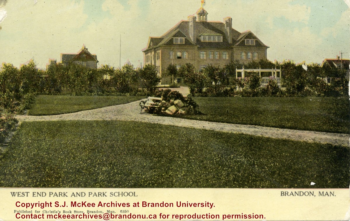
Scope and Content
Postcard shows the West End Park (also known as Stanley Park) and Park School. The school was situated on the southwest corner of Lorne Avenue. A couple of residences surround the school. Walking paths, a park bench, and a gazebo/grandstand can be seen in the park.
Notes
Front of postcard reads: Published for Christie's Book Store, Brandon, Man., 6350. Back of postcard reads: Canadian Souvenir Post Card, Warwick Brothers & Rutter, Limited, Printers, Toronto. The postcard is addressed to Miss Isabella Heastwell of Broderick, Saskatchewan, and is dated July 14, 1910.
Name Access
Park School
West End Park
Lorne Avenue
Stanley Park
Subject Access
postcards
schools
parks
Storage Location
RG 5 photograph storage drawer 2 (hanging photos)
Images
Show Less

International Peace Garden grand opening 1932

http://archives.brandonu.ca/en/permalink/descriptions13774
Part Of
Fred McGuinness collection
Description Level
Item
GMD
graphic
Date Range
1932
Accession Number
20-2009
Part Of
Fred McGuinness collection
Description Level
Item
Series Number
McG 9
Item Number
20-2009.85
Accession Number
20-2009
GMD
graphic
Date Range
1932
Physical Description
5.75" x 3.5" (b/w)
History / Biographical
The International Peace Garden is situated on the international border between Manitoba and North Dakota, adjacent to the Canadian Border Services Boissevain port of entry and the U.S. Customs and Border Protection Agency's Dunseith port of entry. The dedication for the International Peace Garden was held on July 14, 1932. It was estimated that 50,000 people were in attendance on opening day. The park is 9.5-square kilometers or 3.54-square miles.
Custodial History
Pictures were sent to Fred McGuinness in 1970 from E.M. Bergson of Brandon.
Scope and Content
Photograph shows large crowds surrounding a stone cairn draped in American and Union Jack flags. According to the International Peace Garden website, the pictured cairn was built from stones gathered from Manitoba and North Dakota. The crowds gathered for the 1932 dedication of the International Peace Garden.
Notes
The back of the photograph is stamped: Enameloid Velox Print by the Jul 27 1932, Chicago Postal Photo Supplies, Regina, Sask.
Name Access
International Peace Garden
North Dakota
Subject Access
gardens
parks
monuments
Storage Location
RG 5 photograph storage drawer 2 (hanging photos)
Images
Show Less

International Peace Garden grand opening 1932

http://archives.brandonu.ca/en/permalink/descriptions13775
Part Of
Fred McGuinness collection
Description Level
Item
GMD
graphic
Date Range
1932
Accession Number
20-2009
Part Of
Fred McGuinness collection
Description Level
Item
Series Number
McG 9
Item Number
20-2009.86
Accession Number
20-2009
GMD
graphic
Date Range
1932
Physical Description
5.75" x 3.5" (b/w)
History / Biographical
The International Peace Garden is situated on the international border between Manitoba and North Dakota, adjacent to the Canadian Border Services Boissevain port of entry and the U.S. Customs and Border Protection Agency's Dunseith port of entry. The dedication for the International Peace Garden was held on July 14, 1932. It was estimated that 50,000 people were in attendance on opening day. The park is 9.5-square kilometers or 3.54-square miles.
Custodial History
Pictures were sent to Fred McGuinness in 1970 from E.M. Bergson of Brandon.
Scope and Content
Photograph shows large crowds surrounding a stone cairn draped in American and Union Jack flags. According to the International Peace Garden website, the pictured cairn was built from stones gathered from Manitoba and North Dakota. The crowds gathered for the 1932 dedication of the International Peace Garden.
Notes
The back of the photograph is stamped: Enameloid Velox Print by the Jul 27 1932, Chicago Postal Photo Supplies, Regina, Sask.
Name Access
International Peace Garden
North Dakota
Subject Access
gardens
parks
monuments
Storage Location
RG 5 photograph storage drawer 2 (hanging photos)
Images
Show Less

Corner of 10th Street and Princess Avenue, Brandon, Manitoba

http://archives.brandonu.ca/en/permalink/descriptions8387
Part Of
Joseph H. Hughes collection
Description Level
Item
GMD
graphic
Date Range
c. 1930
Accession Number
3-1997
Part Of
Joseph H. Hughes collection
Description Level
Item
Series Number
3-1997.1
Item Number
3-1997.1.14
Accession Number
3-1997
GMD
graphic
Date Range
c. 1930
Physical Description
8 " x 10" (b/w)
Physical Condition
good
Scope and Content
Photograph shows the intersection of 10th Street and Princess Avenue, Brandon, Manitoba. View is facing northwest along west side of the 100-block of 10th Street. A stationary policeman/divider is at the centre of the intersection. Visible businesses include: Doig's, Plaza Shoe Shop, and Cambridge Clothes Shop. A horse-drawn sled is parked in front of Doig's store. The Olympia Block, Cecil Hotel, and CPR Station are visible in the background.
Name Access
Doig's
Plaza Shoe Shop
Cambridge Clothes Shop
Alexandra Block
Strathcona Block
10th Street
Princess Avenue
Subject Access
downtowns
street scenes
Brandon business buildings & facilities before 1940
building exteriors
Transportation
Storage Location
RG 5 photograph storage drawer
Images
Show Less

Rosser Avenue viewbook postcard

http://archives.brandonu.ca/en/permalink/descriptions13877
Part Of
Fred McGuinness collection
Description Level
Item
GMD
graphic
Date Range
1927-1929
Accession Number
20-2009
Part Of
Fred McGuinness collection
Creator
Printed by Photogelatine Engraving Co. Ltd., Ottawa
Description Level
Item
Series Number
McG 9
Item Number
20-2009.187
Accession Number
20-2009
GMD
graphic
Date Range
1927-1929
Physical Description
3.5" x 5.5" (colour)
Material Details
postcard
Scope and Content
Photograph shows the 700-block of Rosser Avenue facing west. Visible businesses on the north side of Rosser Avenue include: Burchill's Music Store, E.W. Woolworth Co. Ltd. 5-10 and 15 Cent Store in the E.E. Evans Block, Empire Hotel, and W.A. Paterson Drugs. Automobiles are parked on both sides of the avenue and at the time the photograph was taken, Rosser Avenue was a two-way street.
Notes
Part of "Souvenir of Brandon, Manitoba, Canada [viewbook], Printed by Photogelatine Engraving Co. Limited, Ottawa." Dates obtained from the Burchill's Music Store Henderson's Brandon City Directory listings (1927-1929). Writing on the front of the photograph reads: Rosser St. [sic.] - Brandon, Man.
Name Access
Rosser Avenue
Burchill's Music Store
Evans Block
Empire Hotel
Subject Access
downtown
street scenes
Transportation
automobiles
Brandon business buildings & facilities before 1940
store exteriors
Storage Location
RG 5 photograph storage drawer 2 (hanging photos)
Arrangement
From 20-2009 photos
Images
Show Less
Part Of
RG 11 Lawrence Stuckey fonds
Description Level
Item
GMD
graphic
Date Range
[ca. 1912]
Accession Number
1-2002
Part Of
RG 11 Lawrence Stuckey fonds
Description Level
Item
Series Number
3.1
Item Number
1-2002.3.1N5
Accession Number
1-2002
GMD
graphic
Date Range
[ca. 1912]
Physical Description
3 1/2" x 5"
Material Details
Negative
Custodial History
For custodial history see the collection level description of the Lawrence Stuckey collection.
Scope and Content
Stanley Park from old PC.
Notes
Shows bandstand
[By "PC" Mr. Stuckey likely meant to indicate Park School (built 1904, demolished 1978). Park School was, at the time the photo was taken, located directly across Lorne Avenue from Stanley Park. P.E. 22/07/09]
Name Access
Stanley Park
Subject Access
parks
Brandon Miscellaneous History
Repro Restriction
The McKee Archives is the copyright holder for the Stuckey materials.
Storage Location
Lawrence Stuckey collection
Images
Show Less

John Indian's Bush

http://archives.brandonu.ca/en/permalink/descriptions9869
Part Of
RG 11 Lawrence Stuckey fonds
Description Level
Item
GMD
graphic
Date Range
July 18, 1978
Accession Number
1-2002
Part Of
RG 11 Lawrence Stuckey fonds
Creator
L.A. Stuckey
Description Level
Item
Series Number
3.1
Item Number
1-2002.3.1NA4(1)
Accession Number
1-2002
GMD
graphic
Date Range
July 18, 1978
Physical Description
2 1/2" x 2 1/2"
Material Details
Negative
History / Biographical
This wedge-shaped tract of woodland was located west of 34th Street on the south side of the Canadian Pacific Railway. It was formerly owned by the Great Northern Railway, and was acquired by the CPR when the GN line was abandoned in 1936. In 1978 Marathon Realty (CPR) sold this 7 acre property to a developer who planned to build condominiums. However this residential development was objected to for two reasons: [The proposed location] was home to many species of flora & fauna, and it was too close to the CPR mainline. Local residents took out a petition against the development. [Mr. Stuckey] wrote a letter to the editor of the Brandon Sun, [expressing the] attitudes of CPR officials, and read a statement to the Provincial Planning Board suggesting development be refused and the area become an undeveloped park. These efforts would prove successful - see file on same.
Custodial History
For custodial history see the collection level description of the Lawrence Stuckey collection.
Scope and Content
John Indian's Bush (also known as Bang's Bush)
Notes
Additional historical information provided by the Fred McGuinness collection (20-2009). Stuckey's letter to the editor appears in the July 22, 1978 issue of The Brandon Sun.
Name Access
John Indian's Bush
Bang's Bush
Subject Access
parks
Brandon Miscellaneous History
Repro Restriction
The McKee Archives is the copyright holder for the Stuckey materials.
Storage Location
Lawrence Stuckey collection
Arrangement
[Mr. Stuckey had put two negatives in the same envelope. They are now separated as NA4(1) and NA4(2).]
Images
Show Less

20 records – page 1 of 1.