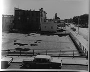
The International Peace Garden is situated on the international border between Manitoba and North Dakota, adjacent to the Canadian Border Services Boissevain port of entry and the U.S. Customs and Border Protection Agency's Dunseith port of entry. The dedication for the International Peace Garden was held on July 14, 1932. It was estimated that 50,000 people were in attendance on opening day. The park is 9.5-square kilometers or 3.54-square miles.
Custodial History
Pictures were sent to Fred McGuinness in 1970 from E.M. Bergson of Brandon.
Scope and Content
Photograph shows the crowded parking lot at the International Peace Garden's 1932 dedication ceremony. People mill amongst the automobiles and tents can be seen in the background.
Notes
The back of the photograph is stamped: Enameloid Velox Print by the Jul 27 1932, Chicago Postal Photo Supplies, Regina, Sask.
Eleanor Kidd Park (est. 1977) is situated on 18th Street North, on the south side of the Assiniboine River, and east of the Thompson twinned bridge. The park was the former site of an animal shelter overseen by Eleanor Kidd. Adjacent to the park are the Eleanor Kidd Gardens, which contains performance and fountain plazas. The sites have been subjected to heavy flooding from 2011 to 2015.
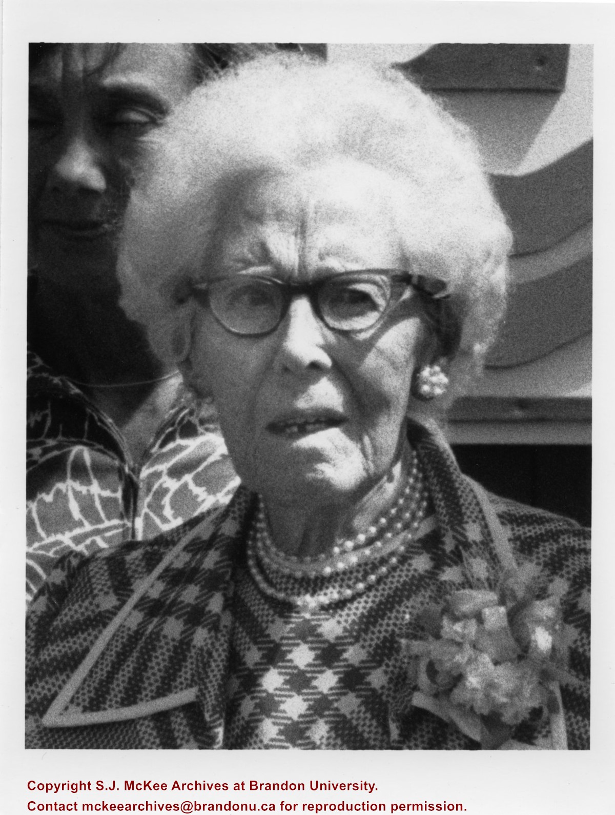
Eleanor Maud Kidd (nee Death) (b.05 Aug 1881, d. 11 July 1978) was born in London, England. She trained as a nurse/midwife at the Liverpool Children's Hospital and worked as a private nurse for affluent families in Italy. She immigrated to Canada in 1913 and lived in Portage la Prairie where she worked as a public health nurse. She ultimately settled in Brandon where she married barber William Wesley Kidd (1873-1951) on November 24, 1921. Mrs. Kidd is credited with incorporating the Brandon SPCA/Humane Society in 1947. She died in Brandon, Manitoba, and is interred in the Brandon Municipal Cemetery. (sources: Brandon Sun 12 July 1978; Brandon Sun 13 July 1978; Manitoba Vital Statistics)
Custodial History
Photograph courtesy of Dirk Aberson
Scope and Content
Photograph is a close-up of Eleanor Kidd posing in front of the Elanor Kidd Park sign.
Donated to Fred McGuinness by Mrs. Marian Gray of Brandon, September 13, 1978.
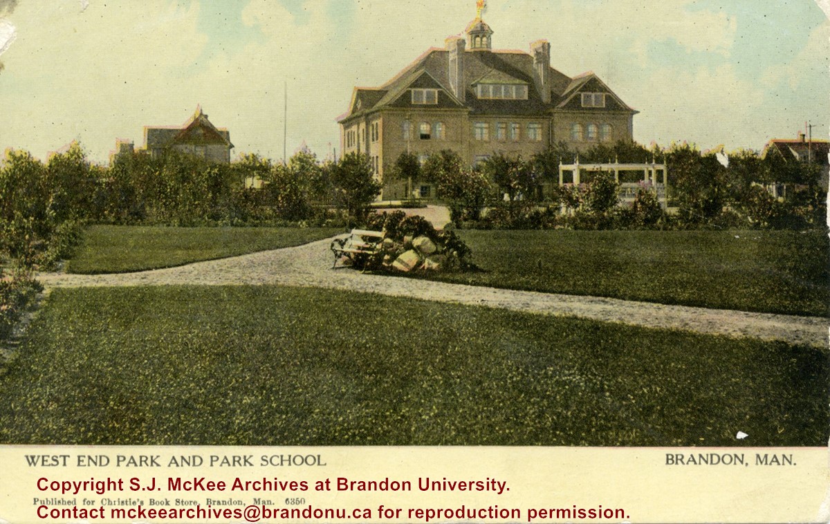
Scope and Content
Postcard shows the West End Park (also known as Stanley Park) and Park School. The school was situated on the southwest corner of Lorne Avenue. A couple of residences surround the school. Walking paths, a park bench, and a gazebo/grandstand can be seen in the park.
Notes
Front of postcard reads: Published for Christie's Book Store, Brandon, Man., 6350. Back of postcard reads: Canadian Souvenir Post Card, Warwick Brothers & Rutter, Limited, Printers, Toronto. The postcard is addressed to Miss Isabella Heastwell of Broderick, Saskatchewan, and is dated July 14, 1910.
The International Peace Garden is situated on the international border between Manitoba and North Dakota, adjacent to the Canadian Border Services Boissevain port of entry and the U.S. Customs and Border Protection Agency's Dunseith port of entry. The dedication for the International Peace Garden was held on July 14, 1932. It was estimated that 50,000 people were in attendance on opening day. The park is 9.5-square kilometers or 3.54-square miles.
Custodial History
Pictures were sent to Fred McGuinness in 1970 from E.M. Bergson of Brandon.
Scope and Content
Photograph shows large crowds surrounding a stone cairn draped in American and Union Jack flags. According to the International Peace Garden website, the pictured cairn was built from stones gathered from Manitoba and North Dakota. The crowds gathered for the 1932 dedication of the International Peace Garden.
Notes
The back of the photograph is stamped: Enameloid Velox Print by the Jul 27 1932, Chicago Postal Photo Supplies, Regina, Sask.
For custodial history see the collection level description of the Lawrence Stuckey collection.
Scope and Content
Stanley Park from old PC.
Notes
Shows bandstand
[By "PC" Mr. Stuckey likely meant to indicate Park School (built 1904, demolished 1978). Park School was, at the time the photo was taken, located directly across Lorne Avenue from Stanley Park. P.E. 22/07/09]
This wedge-shaped tract of woodland was located west of 34th Street on the south side of the Canadian Pacific Railway. It was formerly owned by the Great Northern Railway, and was acquired by the CPR when the GN line was abandoned in 1936. In 1978 Marathon Realty (CPR) sold this 7 acre property to a developer who planned to build condominiums. However this residential development was objected to for two reasons: [The proposed location] was home to many species of flora & fauna, and it was too close to the CPR mainline. Local residents took out a petition against the development. [Mr. Stuckey] wrote a letter to the editor of the Brandon Sun, [expressing the] attitudes of CPR officials, and read a statement to the Provincial Planning Board suggesting development be refused and the area become an undeveloped park. These efforts would prove successful - see file on same.
Custodial History
For custodial history see the collection level description of the Lawrence Stuckey collection.
Scope and Content
John Indian's Bush (also known as Bang's Bush)
Notes
Additional historical information provided by the Fred McGuinness collection (20-2009). Stuckey's letter to the editor appears in the July 22, 1978 issue of The Brandon Sun.
This wedge-shaped tract of woodland was located west of 34th Street on the south side of the Canadian Pacific Railway. It was formerly owned by the Great Northern Railway, and was acquired by the CPR when the GN line was abandoned in 1936. In 1978 Marathon Realty (CPR) sold this 7 acre property to a developer who planned to build condominiums. However this residential development was objected to for two reasons: [The proposed location] was home to many species of flora & fauna, and it was too close to the CPR mainline. Local residents took out a petition against the development. [Mr. Stuckey] wrote a letter to the editor of the Brandon Sun, [expressed the] attitudes of CPR officials, and read a statement to the provincial planning board suggesting development be refused and the area become an undeveloped park. These efforts would prove successful - see file on same.
Custodial History
For custodial history see the collection level description of the Lawrence Stuckey collection.
Scope and Content
John Indian's Bush (also known as Bang's Bush).
Notes
Additional historical information provided by the Fred McGuinness collection (20-2009). Stuckey's letter to the editor appears in the July 22, 1978 issue of The Brandon Sun.
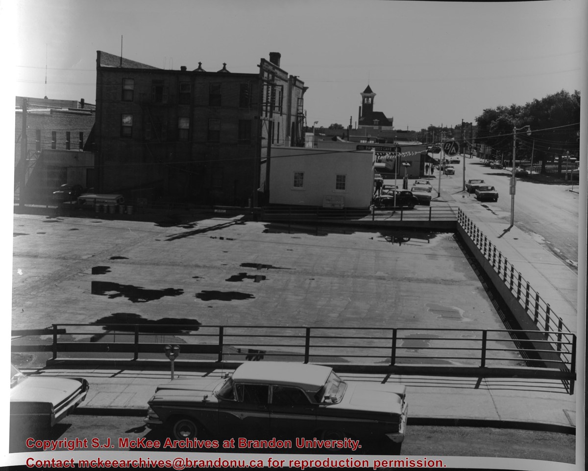
Photograph shows the northeast corner of 10th Street and Princess Avenue facing east. In the background the following Brandon businesses can be seen: back of the Brandon Inn, B/A gas station, The Princess Cafe, and the Central Fire Hall.
Notes
Photograph dated from "Tara's Bulba," the movie playing at the Strand Theatre and similiar vehicles captured in the photograph.
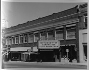
Photograph shows the east side of 10th Street, Brandon, Manitoba. The Strand Theatre marquee shows "Gidget" starring Sandra Dee and Cliff Robertson. Other businesses in the Strand Block include: Ted Heming Jewellers, Waddell's, and Metropolitan Life.
Notes
Photograph dated from "Gidget," the movie playing at the Strand Theatre
Photograph of an east side of 10th Street facing north from Princess Avenue. Visible businesses include: Thunderbird Bowl, Canadian Pacific Telegraphs, Pittsburgh Paint & Glass, Strand Theatre, Trans Canada Credit Loans, Ted Heming Jewellers, Carlton Cafe, McKenzie Seeds, Clement Block, Mitrou's Cafe and Tea Room, and Brandon Musical Supply Ltd. Vehicles parked on 10th Street are facing north.
Notes
Photograph dated from "Tara's Bulba," the movie playing at the Strand Theatre and similiar vehicles captured in the photograph.
Photograph shows Ted Heming Jewellers on the east side of 10th Street, Brandon, Manitoba, with the Strand Theatre to the south of the building complex. Other visible businesses in the Strand Block include: Hughes & Co. Ltd., Smart's Stationery, Waddell's, and Metropolitan Life.
Notes
Photograph dated from "Gidget," the movie playing at the Strand Theatre
Photograph shows the Strand Block on the east side of 10th Street, Brandon, Manitoba. Visible businesses in the Strand Block include: Hughes & Co. Ltd., Smart's Stationery, Waddell's, the Strand Theatre, and Metropolitan Life.
Notes
Back of the photograph is stamped: Clark Smith Studio, per July 27/59
Photograph of east side of 10th Street, Brandon, Manitoba, between Rosser and Princess Avenues. Visible businesses include: The Bank of Montreal, Barclay's Shoe Store, Carlton Cafe (in the former Cigar Factory), and Ted Heming Jewellers. The McKenzie Seed building is visible in the background.
Photograph shows the east side of 10th Street, Brandon, Manitoba, between Rosser and Princess Avenues. Businesses visible in the Brown Block include (from north to south): Singer, Pittsburgh Paint & Glass, O. Stark & Son, Elna Sewing Centre, and Canadian Pacific Telegraphs. The Prince Edward Hotel is visible in the background.
Doig's, originally located on Rosser Avenue, moved to the 10th Street location in 1921.
Scope and Content
Photograph of west side of 10th Street, Brandon, Manitoba, facing northwest. Visible businesses in the Alexander Block include Doig's, Box Brothers Hardware and Allied Hardware Stores, followed by Simpsons-Sears and Barry Neill Men's Wear in the Strathcona Block. The Johnny Smith Block is visible in the background.
Photograph shows the intersection, facing northwest, at 10th Street and Princess Avenue, Brandon, Manitoba. Fitwell Tailors can be seen on the south side of Princess Avenue. Doig's Home Furnishings and The Manufactuerers Life can be seen on the northwest corner. Traffic appears to be travelling both ways on Princess Avenue.
Photograph shows the west side of the 100-block of 10th Street facing northwest. Visible businesses include: Bottomley's Furniture, Recreation Bowling & Billiards, Fashion Fabrics, Brandon News & Record Shop, Bass' Storkland, Beneficial Finance Co., and the Kresge Store. The Johnny Smith Block is visible in the background.
Photograph of west side of 10th Street, Brandon, Manitoba, facing northwest. Visible businesses in the Alexandra Block include Doig's, Box Brothers Hardware and Allied Hardware Stores, followed by Simpsons-Sears and Barry Neill Men's Wear in the Strathcona Block. The Johnny Smith Block is visible in the background.
Photograph shows the west side of 10th Street between Rosser and Princess Avenues. Visible businesses include: Brandon News & Record Shop, Fashion Fabrics, Recreation Bowling & Billiards, Bottomley's, Barry Neill Men's Wear, Simpsons-Sears. Painted on the north face of the Strathcona Block are two advertisements, one for Sutherland and Robertson [Grocery] and the other for Boyd Electric Co. Ltd. Union Jack flags hang from some businesses and light standards.


.jpg?width=1200&404=no-img.jpg&watermark=wmk)
.jpg?width=180&404=no-img.jpg)
.jpg?width=1200&404=no-img.jpg&watermark=wmk)
.jpg?width=180&404=no-img.jpg)


.jpg%3fmaxheight%3d1000%26maxwidth%3d1000%26watermark%3dwmk&description=John+Indian%27s+Bush)
.jpg%3fmaxheight%3d1000%26maxwidth%3d1000%26watermark%3dwmk&description=John+Indian%27s+Bush)
)