Photographs have been glued to a backing board that has warped over time
History / Biographical
Photograph of possible Dakota from Sioux Valley in Brandon for the summer fair.
Scope and Content
Photograph shows street view of north side of Rosser Avenue, primarily the 700 block. Businesses visible in the Beaubier Block include the Empire Hotel. Businesses east of the Empire Hotel are grocer A.M. Percival, the Brandon Hardware Company, and the Arlington Hotel. A number of Aboriginal peoples are driving horse and buggies east along Rosser Avenue as large numbers of spectators look on.
Notes
Writing on the front of the photograph matting reads: 298. One photograph (20-2009.79) is glued above, another (20-2009.81) adjacent. One other is glued on the reverse side. Page appears to be from a photo album.
Photograph given to Fred McGuinness by Helen Turner
Scope and Content
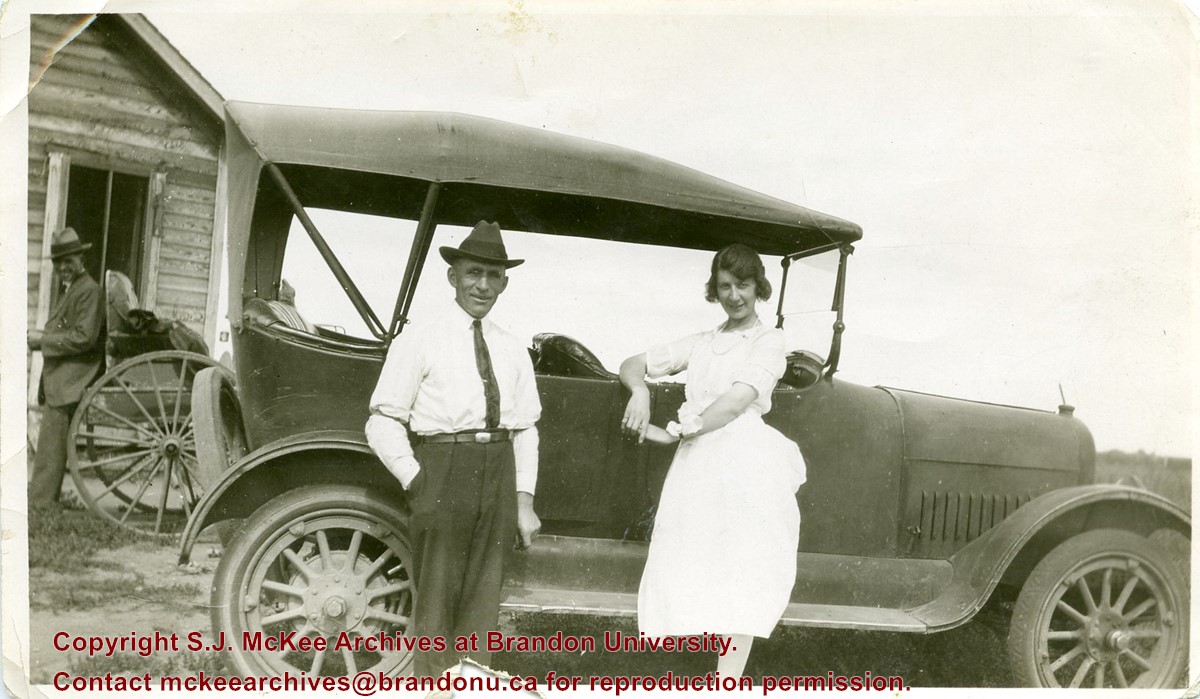
Photograph shows a man - George Porterfield - and woman - Mary Porterfield - posing with a vehicle on a farm property.
Notes
Writing on the back of the photograph reads: Taken in the Summer at one of the neighbour homes George & myself. Note attached to the back of the photograph reads: George & Mary got married on June 6th 1923 and lived on the farm. This is their first car.
Photographs have been glued to a backing board that has warped over time
History / Biographical
Photograph of possible Dakota from Sioux Valley in Brandon for the summer fair.
Scope and Content
Photograph shows street view of north side of Rosser Avenue, primarily the 700 block. Businesses visible in the Fleming Block include: Lowes Brothers Clothing, Robert Hall [Insurance Broker], Manitoba Farmers Hedge and Wire Fence Company. Businesses visible in the Beaubier Block include the Empire Hotel. Businesses east of the Empire Hotel are grocer A.M. Percival and the Brandon Hardware Company. A number of Aboriginal peoples are driving horse and buggies west along Rosser Avenue as spectators look on.
Notes
Writing on the front of the photograph matting reads: 294 July 1906. One photograph (20-2009.10) is glued below and two others are glued on the reverse side. Page appears to be from a photo album.
Photograph shows the 800 block of Rosser Avenue facing west. On the south side of Rosser Avenue the Nation Block, Christie's Bookstore, and Reesor's Clock can be seen. A number of horse and buggies/carriages are travelling along Rosser Avenue.
Photographs have been glued to a backing board that has warped over time
Scope and Content
Photograph shows street view of north side of Rosser Avenue, primarily the 700 block. The Fleming Block, Beaubier Block and its Empire Hotel, A.M. Percival (a grocer), the Brandon Hardware Company (600 block), and the Arlington Hotel (500 block) are visible along the north side of the avenue. The Bank of Hamilton Building on the southeast corner of 8th Street and Rosser appears to be under construction. A sign in the second storey window above the main entrance reads: law office. The streets are muddy and a horse and buggy is traveling west on Rosser Avenue.
Notes
Writing on the front of the photograph matting reads: mud November 12, 1906, 339. The photograph appears to be taken from the interior of a builing on the southwest corner of 8th Street and Rosser Avenue. Page appears to be from a photo album.
The International Peace Garden is situated on the international border between Manitoba and North Dakota, adjacent to the Canadian Border Services Boissevain port of entry and the U.S. Customs and Border Protection Agency's Dunseith port of entry. The dedication for the International Peace Garden was held on July 14, 1932. It was estimated that 50,000 people were in attendance on opening day. The park is 9.5-square kilometers or 3.54-square miles.
Custodial History
Pictures were sent to Fred McGuinness in 1970 from E.M. Bergson of Brandon.
Scope and Content
Photograph shows the crowded parking lot at the International Peace Garden's 1932 dedication ceremony. People mill amongst the automobiles and tents can be seen in the background.
Notes
The back of the photograph is stamped: Enameloid Velox Print by the Jul 27 1932, Chicago Postal Photo Supplies, Regina, Sask.
Photograph is scratched and has been glued to a backing board that has warped over time
Scope and Content
Photograph shows street view of the northeast intersection of the 000 block of 8th Street and Rosser Avenue. Horse and buggies are parked along the east side of 8th Street. Businesses on the east side of 8th Street from Pacific to Rosser Avenues are clearly visible and include: a Lunch Room (likely Aagaard's Lunch Counter), the Hotel Imperial Annex, Liverpool House (a boarding house), R.S. Thompson and Company Real Estate Office (Land Office), a barber shop (likely J. Coulter's), Frank Gowen photography studio, and Fleming's Drug Store. A possible street fair is in progress on Rosser Avenue. One man is standing on a soap box and is surrounded by a crowd in the middle of 8th Street. Another man can be seen standing behind a booth on the northwest street corner. Building construction appears to be happening on the west corner of 8th Street and Rosser Avenue.
Notes
Writing on the front of the photograph matting reads: 297. One photograph (20-2009.80) is glued below the photograph. Another photograph is glued on the reverse side. Page appears to be from a photo album.
Postcard shows a street scene of Donald Street looking south from the Portage Avenue Intersection.
Notes
Writing on the back of the postcard reads: Aug 9, Dear ruth, Aunt Eva, Aunt Annie and Fred were over to the bowlnig greens tonight. Every one fine. Doddy. Postcard is addressed to Ruth McGuinness, 337-17th St., Brandon, Man. Postmarked: Winnipeg 12 PM Aug 10 1927 Man.
According to Russ Gourluck (Silver Screens on the Prairie, Winnipeg: Great Plains Publications, 2012, 26), the Orpheum Theatre was in operation from 1917 to 1920 when it then became the Willis Theatre.
Scope and Content
Postcard shows the 100 block of 10th Street facing north. The CPR train station can be seen at the end of 10th Street. The sign for the Rex Cafe is visible on the west side of 10th Street. On the east side of 10th Street, billboards for Campbell & Campbell furniture are visible as well as signs for Pianos and the Orpheum Theatre. Motorists and cyclists share the road. Street car tracks run the length of 10th Street.
Notes
Postcard was manufactured by T.B. [Tichnor Brothers, Inc., 1908-1987] Cambridge, Massachusetts.
After demise of the streetcars, a transit system was started by MacArthur Transportation Co. with three routes, an east end loop, a south end loop, and a west end loop, with terminal at 8th St. & Rosser Ave. The E & W was operated as a continuous route with two locally built coach bodies on new Maple Leaf trucks. A secondhand, larger, Leland coach was acquired for the S. end, which was replaced by a large GMC about 1938.
Custodial History
For custodial history see the collection level description of the Lawrence Stuckey collection.
Photograph shows the intersection of 10th Street and Princess Avenue, Brandon, Manitoba. View is facing northwest along west side of the 100-block of 10th Street. A stationary policeman/divider is at the centre of the intersection. Visible businesses include: Doig's, Plaza Shoe Shop, and Cambridge Clothes Shop. A horse-drawn sled is parked in front of Doig's store. The Olympia Block, Cecil Hotel, and CPR Station are visible in the background.
Photograph shows the 700-block of Rosser Avenue facing west. Visible businesses on the north side of Rosser Avenue include: Burchill's Music Store, E.W. Woolworth Co. Ltd. 5-10 and 15 Cent Store in the E.E. Evans Block, Empire Hotel, and W.A. Paterson Drugs. Automobiles are parked on both sides of the avenue and at the time the photograph was taken, Rosser Avenue was a two-way street.
Notes
Part of "Souvenir of Brandon, Manitoba, Canada [viewbook], Printed by Photogelatine Engraving Co. Limited, Ottawa." Dates obtained from the Burchill's Music Store Henderson's Brandon City Directory listings (1927-1929). Writing on the front of the photograph reads: Rosser St. [sic.] - Brandon, Man.
Photographs have been glued to a backing board that has warped over time
Scope and Content
Photograph shows street view of north side of Rosser Avenue, primarily the 700 block. Horse and buggies are travelling on the avenue and pedestrians fill the sidewalks. Union Jacks and English flags are mounted from the windows on the Fleming and Beaubier blocks. Flag banners are drapped across Rosser Avenue. Businesses visible in the Fleming Block include: Lowes Brothers Clothing and Spring Park Nurseries. Businesses visible in the Beaubier Block include the Empire Hotel. Businesses east of the Empire Hotel are grocer A.M. Percival and the Brandon Hardware Company. An advertisement for the Northern Bank is affixed to a telephone pole on the southside of the street.
Notes
Writing on the front of the photograph matting reads: July 1 1906, 314. One photograph (20-2009.8) is glued below and another, 20-2009.6, is glued on the reverse side. Page appears to be from a photo album.
Photograph shows a street view of 10th Street facing north. There are many automobiles parked along the street and several pedestrians in summer dress are on the sidewalks and street. Visible business signs include: Hentzman & Co. Pianos (possibly belonging to J.J.H. McLean Co. Ltd.), the Strand Theatre, T & D Clothes, Campbell & Campbell, the CPR Station, and Bowling Alley and Billiards.
Notes
Part of "Souvenir of Brandon, Manitoba, Canada [viewbook], Printed by Photogelatine Engraving Co. Limited, Ottawa." Dates obtained from the Burchill's Music Store Henderson's Brandon City Directory listings (1927-1929). Writing on the front of the photograph reads: 10th St., looking north (C.P.R. Station at end of Street) Brandon, Man.
Photograph shows the CPR Train Station on Pacific Avenue and 10th Street.
Notes
Part of "Souvenir of Brandon, Manitoba, Canada [viewbook], Printed by Photogelatine Engraving Co. Limited, Ottawa." Dates obtained from the Burchill's Music Store Henderson's Brandon City Directory listings (1927-1929). Writing on the front of the photograph reads: CPR Station, Brandon, Man.
Photographs have been glued to a backing board that has warped over time
Scope and Content
Photograph shows street view of north side of Rosser Avenue, primarily the 700 block. Horse and buggies are travelling on the avenue and pedestrians fill the sidewalks. Union Jacks and English flags are mounted from the windows on the Fleming and Beaubier blocks. Flag banners are drapped across Rosser Avenue. Businesses visible in the Fleming Block include: Lowes Brothers Clothing and Spring Park Nurseries. Businesses visible in the Beaubier Block include the Empire Hotel. Businesses east of the Empire Hotel are grocer A.M. Percival and the Brandon Hardware Company. An advertisement for the Northern Bank is affixed to a telephone pole on the southside of the street. The street is lined with litter and a number of dogs can be seen roaming the area.
Notes
Writing on the front of the photograph matting reads: 313 July 1906. One photograph (20-2009.8) is glued below and another, 20-2009.6, is glued on the reverse side. Page appears to be from a photo album.
Photograph shows a southwest view of the Prince Edward Hotel and train station.
Notes
Part of "Souvenir of Brandon, Manitoba, Canada [viewbook], Printed by Photogelatine Engraving Co. Limited, Ottawa." Dates obtained from the Burchill's Music Store Henderson's Brandon City Directory listings (1927-1929). Writing on the front of the photograph reads: Prince Edward Hotel, Brandon, Man.
For custodial history see the collection level description of the Lawrence Stuckey collection.
Scope and Content
George MacArthur, President of Provincial Exhibition 1964 - 1967; President of Winter Fair 1961 - 1964.
Notes
Mr. Stuckey originally placed 32 negatives in one envelope labeled “M – Presidents of Fair Boards 1882 – 1972”; We have separated and renumbered these negatives as M30(1) to M30(32) inclusively; Records of the Provincial Exhibition Association are held in the S.J. McKee Archives (RG2) including photos of board members.


.jpg?width=1200&404=no-img.jpg&watermark=wmk)
.jpg?width=180&404=no-img.jpg)
.jpg%3fmaxheight%3d1000%26maxwidth%3d1000%26watermark%3dwmk&description=George+MacArthur)