Skip header and navigation

Revise Search

20 records – page 4 of 1.

A.W. Evans & Company Hardware & Implements

http://archives.brandonu.ca/en/permalink/descriptions14052
Part Of
Fred McGuinness collection
Description Level
Item
GMD
graphic
Date Range
[19--]
Accession Number
1-2015
Part Of
Fred McGuinness collection
Description Level
Item
Series Number
McG 9
Item Number
1-2015.122
Accession Number
1-2015
GMD
graphic
Date Range
[19--]
Physical Description
3" x 2" (b/w)
Scope and Content
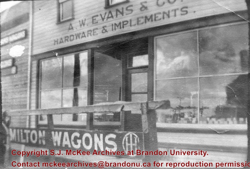
Photograph shows the storefront of A.W. Evans & Co. Hardware & Implements. A hitching post with an advertisement for Milton Wagons is in front of the store.
Name Access
A.W. Evans & Co.
Subject Access
building exteriors
hardware stores
Storage Location
RG 5 photograph storage drawer 2 (hanging photos)
Arrangement
BR #3 Family pictures
Images
Show Less

A.W. Evans & Company Hardware & Implements

http://archives.brandonu.ca/en/permalink/descriptions14053
Part Of
Fred McGuinness collection
Description Level
Item
GMD
graphic
Date Range
[19--]
Accession Number
1-2015
Part Of
Fred McGuinness collection
Description Level
Item
Series Number
McG 9
Item Number
1-2015.123
Accession Number
1-2015
GMD
graphic
Date Range
[19--]
Physical Description
3" x 2" (colour)
Scope and Content
Photograph shows the storefront of A.W. Evans & Co. Hardware & Implements. A horse is next to the hitching post that has an advertisement for Hamilton Wagons in front of the store.
Name Access
A.W. Evans & Co.
Subject Access
building exteriors
hardware stores
Storage Location
RG 5 photograph storage drawer 2 (hanging photos)
Arrangement
BR #3 Family pictures
Images
Show Less

Race track at Exhibition Grounds, Brandon, Man.

http://archives.brandonu.ca/en/permalink/descriptions13779
Part Of
Fred McGuinness collection
Description Level
Item
GMD
graphic
Date Range
c.1910
Accession Number
20-2009
Part Of
Fred McGuinness collection
Description Level
Item
Series Number
McG 9
Item Number
20-2009.90
Accession Number
20-2009
GMD
graphic
Date Range
c.1910
Physical Description
5.5" x 3.5" (colour)
Material Details
postcard
Physical Condition
Postcard has been issued. Corners are worn.
Scope and Content
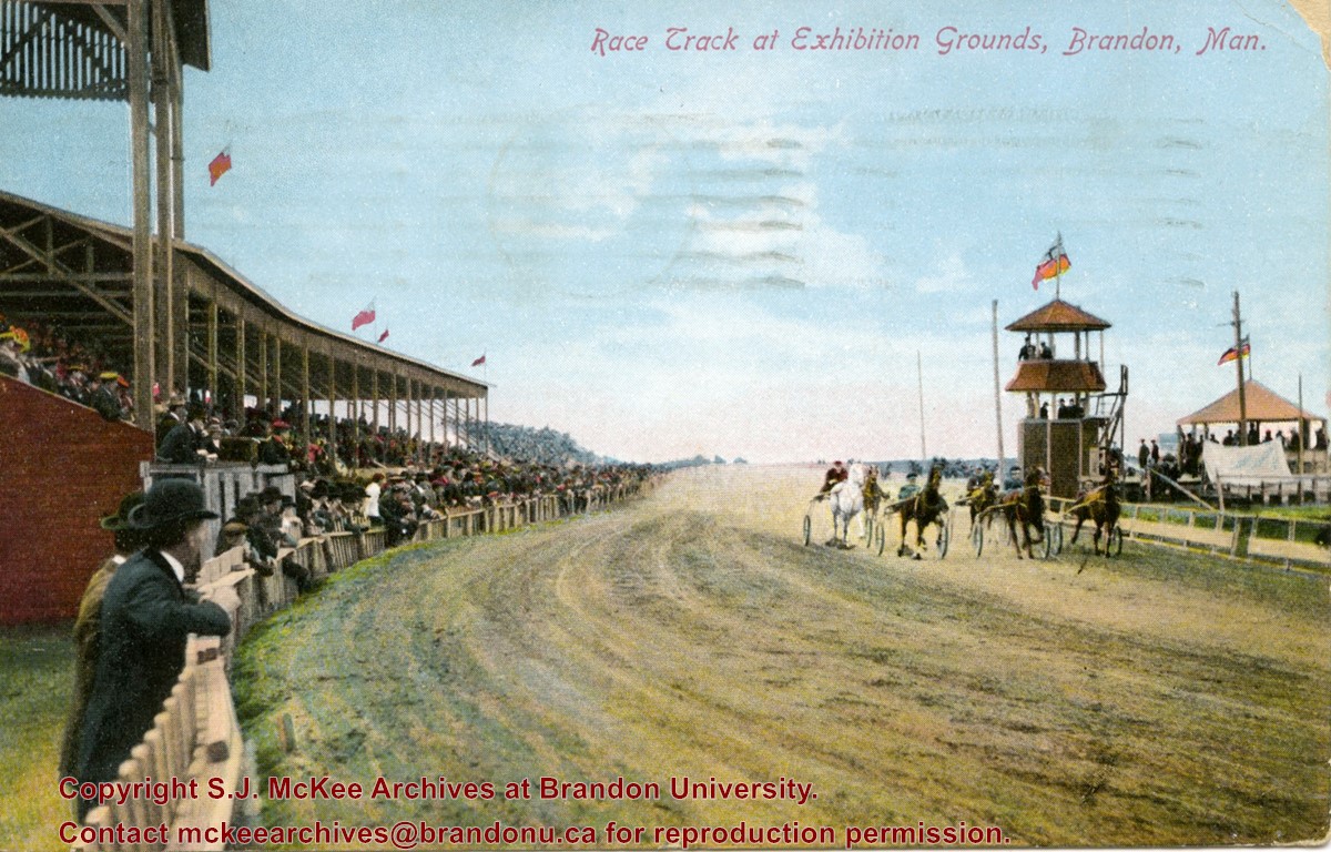
Postcard shows the grandstand and race track located at the Exhibition Grounds (now the site of the Keystone Centre/Westman Communications Place) in the south end of Brandon, Manitoba. The bleachers are filled with people and spectators also line the fence alongside the track. Five harness racers are making their way along the track. An observation tower and possible gazebo for dignitaries is located inside the track.
Notes
The back of the postcard is address to Mrs. Sharpe of Banff, Alberta. A green King George One Cent stamp has been postmarked Sault Ste. Maire, Ont., July 6, 1910. The message reads: Lake Superior, My dear. How are you? Glad you are charmed with B. don't get too fat. Tell Mrs. Coates my state room companion is Miss Rutherford of B. Coll: she got on at Port Arthur. Having a lovely trip. It was hard parting at B. .......Address 14 Deer Park, Toronto. Postcard manufactured by Stedman Bros. Ltd., Brantford, Canada. S.B. 2376. Made in Germany.
Name Access
Brandon Fairgrounds
Subject Access
fairs
exhibitions
Brandon Exhibitions & Facilities
race tracks
horse racing
Storage Location
RG 5 photograph storage drawer 2 (hanging photos)
Images
Show Less

Bridgeman-Osmond homestead - Harding, Manitoba

http://archives.brandonu.ca/en/permalink/descriptions14168
Part Of
Fred McGuinness collection
Description Level
Item
GMD
graphic
Date Range
c.1901
Accession Number
1-2015
Part Of
Fred McGuinness collection
Description Level
Item
Series Number
McG 9
Item Number
1-2015.237
Accession Number
1-2015
GMD
graphic
Date Range
c.1901
Physical Description
6.25" x 4" (b/w)
History / Biographical
Mrs. Hilda Rosa Osmond (nee Bridgeman) was born in Hampshire, England in 1888 to parents Edwin Samuel Bridgeman (b.16 Jul 1852; d. 19 June 1922, Brandon) and Rosa Holkham (b. 26 Mar 1859; d. 27 May 1927, Brandon). Edwin was a sailor and Rosa was a dressmaker. Following the death of her brother Edwin Frederick Bridgeman (1886-1890), the family immigrated to Canada in 1891. The Bridgeman's took the train to Griswold, Manitoba, and settled near Edwin's brother, Albert Bridgeman, and together they farmed the N 1/2 of 36-12-23. The Bridgeman's had three more children, Ellen Grace (b. 27 Jan 1893; d. 22 Feb 1893), Harry Volantine/Valentine (b. 14 Feb 1894), and Charlie Cuthbert (b. 03 Aug 1896; d. 25 Aug 1901). Mr. and Mrs. Edwin Bridgeman retired in 1913 and moved to Brandon where they lived until their respective deaths. The couple are interred in the Brandon Municipal Cemetery. Hilda married William Arthur Osmond (b. 1867; d. 26 Oct 1943) of Baisingstoke, England, on 31 Jan 1913. They had a daughter Nellie who later married Glen Mossey. The family continued to farm the property on section 36. Hilda Rosa Osmond passed away in 1980 at the age of 91. She is interred in the Greenwood Cemetery near Harding, Manitoba, where her husband and siblings also rest. (Sources: England, Births and Christenings, 1538-1975. Salt Lake City, Utah: FamilySearch, 2013 [online]; Findagrave.com; Harding History Committee, Home to Harding 1879-1981 (Brandon: Leech Printing, 1981); Manitoba Vital Statistics Database)
Custodial History
Photograph given to Fred McGuinness by Burton Strange of Kenton, 25 Nov 1974
Scope and Content
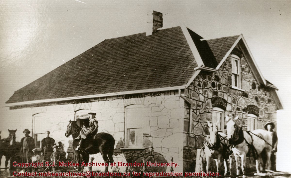
Photograph shows a field stone house builty in 1901 by Edwin and Rosa Bridgeman near Harding, Manitoba. Edwin and Rosa Bridgeman are pictured on the right with Harry and Charlie, shortly before Charlie's death. Hilda sits atop the horse. Albert Bridgeman is pictured on the right with a horse team.
Notes
Photograph was published in the community history by Harding History Committee, Home to Harding 1879-1981 (Brandon: Leech Printing, 1981), 50
Name Access
Hilda Rosa Osmond
Hilda Osmond
Harding, Manitoba
Subject Access
Pioneers
homesteads
farming
residences
horses
families
children
Storage Location
RG 5 photograph storage drawer 2 (hanging photos)
Arrangement
McG 4.1 File 49
Images
Show Less

Aerial view: Brandon College

http://archives.brandonu.ca/en/permalink/descriptions594
Part Of
Brandon University Photograph collection
Description Level
Item
GMD
graphic
Date Range
[fall 1964?]
Part Of
Brandon University Photograph collection
Description Level
Item
Series Number
2.1
Item Number
BUPC 2.1.2
GMD
graphic
Date Range
[fall 1964?]
Physical Description
5" x 4" (b/w)
Scope and Content
Brandon College looking south from 19th Street. Photograph was taken after Flora Cowan Hall was built but before construction of the Education Building.
Subject Access
aerial photographs
campus photographs
campus buildings
Brandon streets
Images
Show Less

Brandon University campus construction

http://archives.brandonu.ca/en/permalink/descriptions8005
Part Of
Brandon University Photograph collection
Description Level
Item
GMD
graphic
Date Range
c. 1996
Part Of
Brandon University Photograph collection
Creator
Photographer: Sandy Black
Description Level
Item
Series Number
2.1
Item Number
BUPC 2.1.71
GMD
graphic
Date Range
c. 1996
Physical Description
4" x 6" (colour)
Scope and Content
View is northeast probably from the roof of McMaster Hall. Photograph shows the construction of the new roof on Clark Hall and the Brandon College Building. A portion of the east side of the 000 and 100 blocks of 18th Street, as well as the corner of 18th Street and Rosser Avenue are visible in the upper left hand corner. This includes the "Downtown Brandon" sign.
Subject Access
campus photographs
campus buildings
campus construction
Brandon streets
Images
Show Less

Brandon University campus construction

http://archives.brandonu.ca/en/permalink/descriptions8006
Part Of
Brandon University Photograph collection
Description Level
Item
GMD
graphic
Date Range
c. 1996
Part Of
Brandon University Photograph collection
Creator
Photographer: Sandy Black
Description Level
Item
Series Number
2.1
Item Number
BUPC 2.1.72
GMD
graphic
Date Range
c. 1996
Physical Description
6" x 4" (colour)
Scope and Content
View is north northeast probably from the roof of McMaster Hall. Photograph shows the construction of the new roof on Clark Hall and the Brandon College Building, as well as the construction of the extension to Clark Hall and the skywalk. Portions of the city as far north as the Assiniboine River are also visible.
Subject Access
campus photographs
campus buildings
campus construction
Brandon streets
Images
Show Less

Brandon University campus construction

http://archives.brandonu.ca/en/permalink/descriptions8018
Part Of
Brandon University Photograph collection
Description Level
Item
GMD
graphic
Date Range
c. 1996
Part Of
Brandon University Photograph collection
Description Level
Item
Series Number
2.1
Item Number
BUPC 2.1.84
GMD
graphic
Date Range
c. 1996
Physical Description
6" x 4" (colour)
Scope and Content
View is north northeast from the roof of McMaster Hall. Photograph shows the campus under construction during the renovation of the Brandon College Building and Clark Hall. The photograph was taken in late fall after the roof had been removed from the buildings but before the construction of the extension of Clark Hall. Construction materials litter the courtyard and driveway. The view looking north extends to The North Hill - a number of residential blocks, particularly to the northeast of 18th Street are visible. Buildings include the International Harvester Building and Kin Village.
Subject Access
campus photographs
campus buildings
campus construction
Brandon streets
Images
Show Less

Brandon University campus construction

http://archives.brandonu.ca/en/permalink/descriptions8020
Part Of
Brandon University Photograph collection
Description Level
Item
GMD
graphic
Date Range
c. 1996
Part Of
Brandon University Photograph collection
Creator
Photographer: Sandy Black
Description Level
Item
Series Number
2.1
Item Number
BUPC 2.1.86
GMD
graphic
Date Range
c. 1996
Physical Description
6" x 4" (colour)
Scope and Content
View is north northeast probably from the roof of McMaster Hall. Photograph shows the construction of the new roof on Clark Hall and the Brandon College Building, as well as the construction of the extension to Clark Hall and the skywalk. The view looking north extends to The North Hill - a number of residential blocks, particularly to the northeast of 18th Street are visible. Buildings include the International Harvester Building and Kin Village.
Subject Access
campus photographs
campus buildings
campus construction
Brandon streets
Images
Show Less

Aerial view - Brandon University campus

http://archives.brandonu.ca/en/permalink/descriptions7989
Part Of
Brandon University Photograph collection
Description Level
Item
GMD
graphic
Date Range
c. 2000
Part Of
Brandon University Photograph collection
Creator
Photograph commissioned by Brandon University and taken by Yourview Aerial Scenics Ltd.
Description Level
Item
Series Number
2.1
Item Number
BUPC 2.1.55
GMD
graphic
Date Range
c. 2000
Physical Description
6" x 4" (colour)
Scope and Content
View is southwest from approximatley 16th Street between Princess and Rosser Avenues. Photograph shows the Brandon University campus, as well as surrounding residential blocks, including Flemming, J.R. Reid and Vincent Massey schools.
Subject Access
aerial photographs
campus photographs
campus buildings
Brandon streets
Images
Show Less

Aerial view - Brandon University campus

http://archives.brandonu.ca/en/permalink/descriptions7990
Part Of
Brandon University Photograph collection
Description Level
Item
GMD
graphic
Date Range
c. 2000
Part Of
Brandon University Photograph collection
Creator
Photograph commissioned by Brandon University and taken by Yourview Aerial Scenics Ltd.
Description Level
Item
Series Number
2.1
Item Number
BUPC 2.1.56
GMD
graphic
Date Range
c. 2000
Physical Description
6" x 4" (colour)
Scope and Content
View is west southwest from approximatley 16th Street between Princess and Lorne Avenues. Photograph shows the Brandon University campus, as well as surrounding residential blocks between 16th and 23rd Streets, Princess and Louise Avenues..
Subject Access
aerial photographs
campus photographs
campus buildings
Brandon streets
Images
Show Less

Aerial view - Brandon University campus

http://archives.brandonu.ca/en/permalink/descriptions7991
Part Of
Brandon University Photograph collection
Description Level
Item
GMD
graphic
Date Range
c. 2000
Part Of
Brandon University Photograph collection
Creator
Photograph commissioned by Brandon University and taken by Yourview Aerial Scenics Ltd.
Description Level
Item
Series Number
2.1
Item Number
BUPC 2.1.57
GMD
graphic
Date Range
c. 2000
Physical Description
6" x 4" (colour)
Scope and Content
View is west from approximatley 17th Street between Lorne and Louise Avenues. Photograph shows a portion of the Brandon University campus (excluding the Education Building and anything north of it), as well as surrounding residential blocks from approximatley 17th Street to 22nd Street.
Subject Access
aerial photographs
campus photographs
campus buildings
Brandon streets
Images
Show Less

Aerial view - Brandon University campus

http://archives.brandonu.ca/en/permalink/descriptions7992
Part Of
Brandon University Photograph collection
Description Level
Item
GMD
graphic
Date Range
c. 1990
Part Of
Brandon University Photograph collection
Description Level
Item
Series Number
2.1
Item Number
BUPC 2.1.58
GMD
graphic
Date Range
c. 1990
Physical Description
5" x 3.5" (colour)
Scope and Content
View is west northwest from approximatley 16th Street and Louise Avenue. Photograph shows the Brandon University campus, prior to the Library Extension, and a large portion of the city to the west of the campus.
Subject Access
aerial photographs
campus photographs
campus buildings
Brandon streets
Images
Show Less

Aerial view - Brandon University campus

http://archives.brandonu.ca/en/permalink/descriptions7993
Part Of
Brandon University Photograph collection
Description Level
Item
GMD
graphic
Date Range
c. 1990
Part Of
Brandon University Photograph collection
Description Level
Item
Series Number
2.1
Item Number
BUPC 2.1.59
GMD
graphic
Date Range
c. 1990
Physical Description
5" x 3.5" (colour)
Scope and Content
View is northwest from approximatley 16th Street and Louise Avenue. Photograph shows the Brandon University campus, prior to the Library Extension, and a large portion of the city to the west of the campus.
Subject Access
aerial photographs
campus photographs
campus buildings
Brandon streets
Show Less

Aerial view - Brandon College looking southwest

http://archives.brandonu.ca/en/permalink/descriptions601
Part Of
Brandon University Photograph collection
Description Level
Item
GMD
graphic
Date Range
[1963-1966]
Part Of
Brandon University Photograph collection
Description Level
Item
Series Number
2.1
Item Number
BUPC 2.1.8
GMD
graphic
Date Range
[1963-1966]
Physical Description
5" x 4" (b/w)
Scope and Content
Image shows the Brandon College campus from 17th Street looking southwest. The photo was taken after the completion of the original Music Building in 1963, but construction of the Education Building. Also visible are a number of properties on the 200 block of 18th Street and the 200 block of 20th Street.
Subject Access
aerial photographs
campus photographs
campus buildings
Brandon streets
Images
Show Less

Aerial view: Brandon College from 23rd Street

http://archives.brandonu.ca/en/permalink/descriptions602
Part Of
Brandon University Photograph collection
Description Level
Item
GMD
graphic
Date Range
[1963-1966]
Part Of
Brandon University Photograph collection
Description Level
Item
Series Number
2.1
Item Number
BUPC 2.1.9
GMD
graphic
Date Range
[1963-1966]
Physical Description
5" x 4" (b/w)
Scope and Content
Image is looking east northeast from approximately the 300 block of 23rd Street between Lorne and Louise Avenues. Photograph shows the Brandon College campus after the opening of the original Music Building in 1963, but before the construction of the Education Building in 1966. A number of house on the 300 blocks of 22nd and 21st Streets are visible in the foreground, with the A.E. McKenzie Seed Co., the Prince Edward Hotel and various grain elevators on the horizon.
Subject Access
aerial photographs
campus photographs
campus buildings
Brandon streets
Grain elevators
Images
Show Less

Dominion Exhibition Display Building II and midway

http://archives.brandonu.ca/en/permalink/descriptions13726
Part Of
Fred McGuinness collection
Description Level
Item
GMD
graphic
Date Range
1913
Accession Number
20-2009
Part Of
Fred McGuinness collection
Description Level
Item
Series Number
McG 9
Item Number
20-2009.36
Accession Number
20-2009
GMD
graphic
Date Range
1913
Physical Description
4.5" x 3.75" (b/w)
Scope and Content
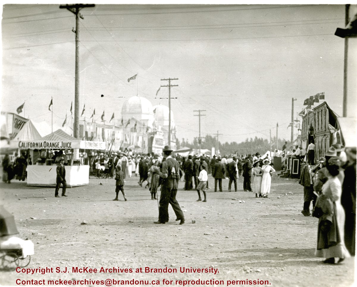
Photograph shows the midway at the 1913 Dominion Fair. Attractions include California Orange Juice stand and Patterson's Animal Trainer Show. The Dominion Exhibition Display Building II can be seen in the background.
Notes
Photograph appears to be a part of a sequence of photographs, see 20-2009.30 to 20-2009.40
Name Access
Dominion Fair
Dominion Exhibition
Dominion Exhibition Display Building II
Dome Building
Subject Access
fairs
exhibitions
building exteriors
Storage Location
RG 5 photograph storage drawer 2 (hanging photos)
Images
Show Less

Brandon University campus

http://archives.brandonu.ca/en/permalink/descriptions7999
Part Of
Brandon University Photograph collection
Description Level
Item
GMD
graphic
Date Range
c. 1993
Part Of
Brandon University Photograph collection
Description Level
Item
Series Number
2.1
Item Number
BUPC 2.1.65
GMD
graphic
Date Range
c. 1993
Physical Description
4" x 6" (colour)
Scope and Content
View is southwest from the roof of the George T. Richardson Centre. Photograph shows the curved glass wall of the John E. Robbins Library, the walkway between the Library and the Dining Hall, the Dining Hall and Darrach Hall.
Subject Access
campus photographs
campus buildings
Images
Show Less

Brandon University campus landscaping

http://archives.brandonu.ca/en/permalink/descriptions8017
Part Of
Brandon University Photograph collection
Description Level
Item
GMD
graphic
Date Range
c. 1993
Part Of
Brandon University Photograph collection
Description Level
Item
Series Number
2.1
Item Number
BUPC 2.1.83
GMD
graphic
Date Range
c. 1993
Physical Description
6" x 4" (colour)
Scope and Content
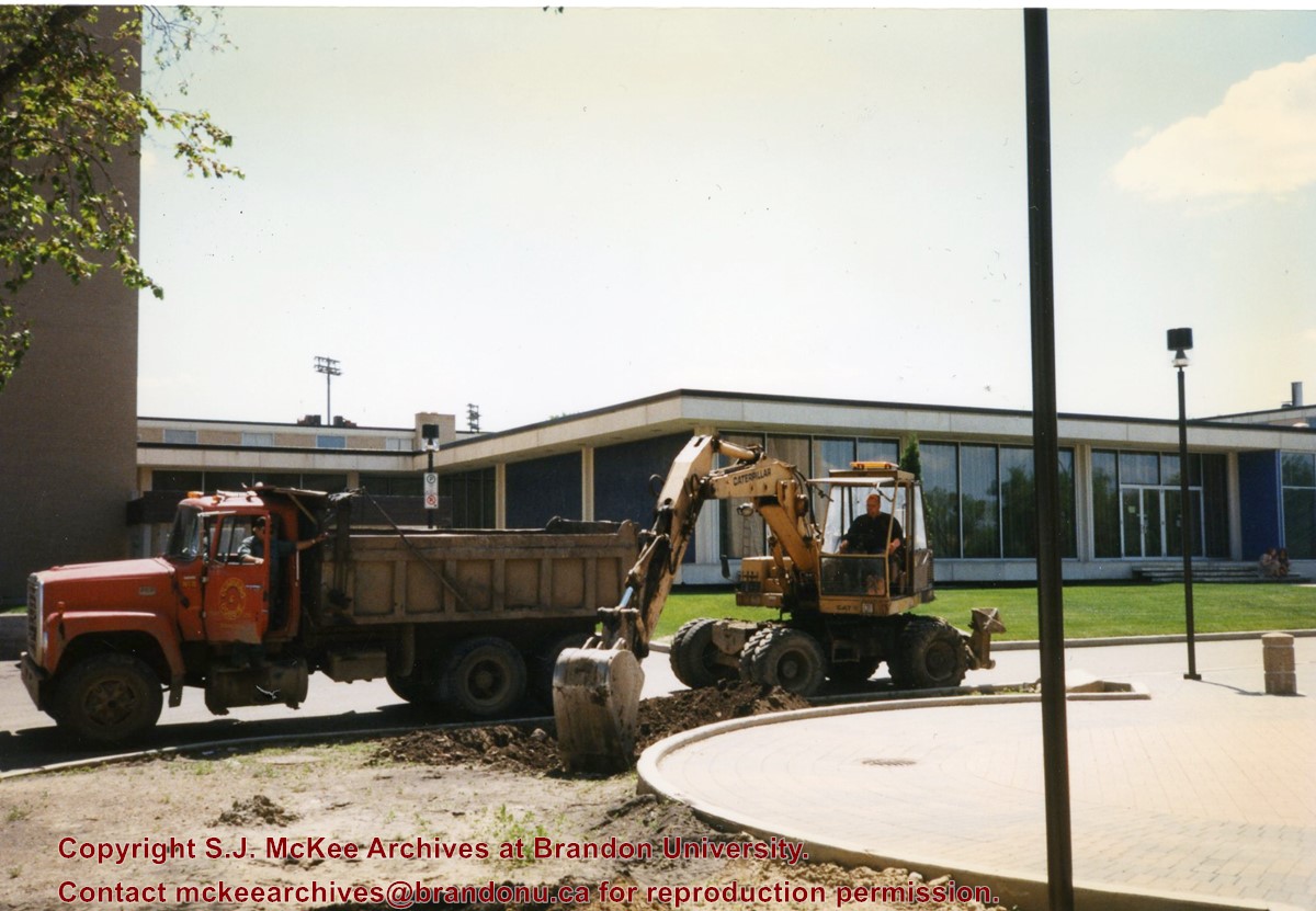
Photograph shows a backhoe and a dump truck on the north side of McMaster Hall during the landscaping of the flower bed on the southeast corner of the George T. Richardson Centre (John E. Robbins Library). The Dining Hall is in the background.
Subject Access
campus photographs
campus buildings
Images
Show Less

Royal George Hotel

http://archives.brandonu.ca/en/permalink/descriptions13712
Part Of
Fred McGuinness collection
Description Level
Item
GMD
graphic
Date Range
1912
Accession Number
20-2009
Part Of
Fred McGuinness collection
Description Level
Item
Series Number
McG 9
Item Number
20-2009.22
Accession Number
20-2009
GMD
graphic
Date Range
1912
Physical Description
9.75" x 7.5" (b/w)
Physical Condition
photograph is torn and has scotch tape residue
Scope and Content
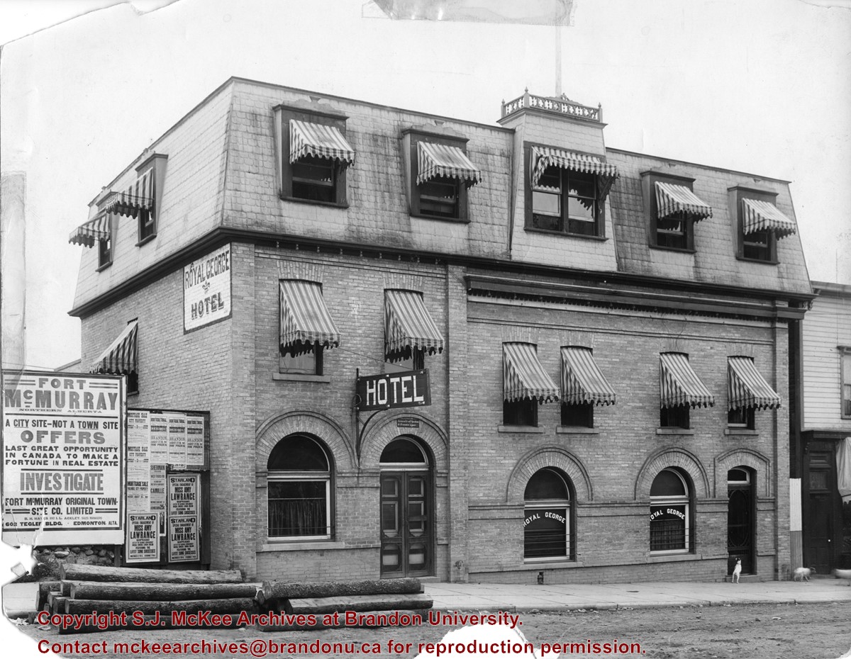
Photograph shows the exterior of the Royal George Hotel located at 142-6th Street, Brandon. Striped awnings cover the second and third storey windows of the hotel. Dogs roam the sidewalk in front of the hotel. Advertisements cover the fence adjacent to the hotel and include: Fort McMurray town site settlement; Mortgage sale for city property; Starland Theatre featuring Miss Amy Lawrence, Soprano; Sherman Theatre; 15th Annual Horticultural Exhibition
Notes
Date ascertained from 15th Annual Horticultural Exhibition advertisement posted on fence adjacent to hotel. Address obtained from Henderson's Brandon City Directory for 1913.
Name Access
Royal George Hotel
Starland Theatre
Sherman Theatre
Horticultural Exhibition
6th Street
Subject Access
hotels
building exteriors
advertising
dogs
Storage Location
RG 5 photograph storage drawer 2 (hanging photos)
Images
Show Less

20 records – page 4 of 1.