Skip header and navigation

Revise Search

20 records – page 5 of 1.

Western Motors at southwest corner 10th and Princess Avenue, Brandon, Manitoba

http://archives.brandonu.ca/en/permalink/descriptions8415
Part Of
Joseph H. Hughes collection
Description Level
Item
GMD
graphic
Date Range
c.1955
Accession Number
3-1997
Part Of
Joseph H. Hughes collection
Description Level
Item
Series Number
3-1997.1
Item Number
3-1997.1.37
Accession Number
3-1997
GMD
graphic
Date Range
c.1955
Physical Description
10" x 8" (b/w)
Physical Condition
good
Scope and Content
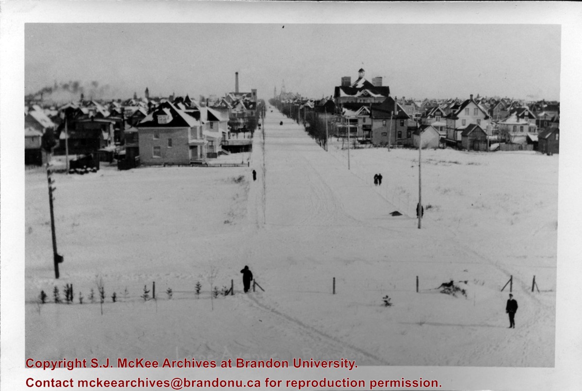
Photograph shows Western Motors Ltd. on the southwest corner of 10th Street and Princess Avenue. To the west of the car dealership/garage is the Greyhound Bus Station and its Maxwell House Cafe as well as the court house.
Name Access
Greyhound
Western Motors Ltd.
Princess Avenue
Maxwell House Grill
Court House
Subject Access
downtowns
street scenes
Brandon business buildings & facilities after 1940
building exteriors
winter
bus depots
garages
Storage Location
RG 5 photograph storage drawer
Images
Show Less

BUPC 1: Convocation, scholarships and awards

http://archives.brandonu.ca/en/permalink/descriptions3
Part Of
Brandon University Photograph Collection
Description Level
Series
GMD
graphic
Date Range
1965-1999
Part Of
Brandon University Photograph Collection
Description Level
Series
Series Number
1
GMD
graphic
Date Range
1965-1999
Physical Description
Approximately 460 photographs and 5000 negatives
History / Biographical
Convocation for Brandon University was held in the Westman Centennial Auditorium from 1967 to 200? Prior to 1967, convocation was held in the Gym.
Scope and Content
Series consist of two sub-series, including: (1) Convocation, scholarships and awards; and (2) Morris Predinchuck fonds.
Subject Access
Convocation
Storage Range
Photograph storage drawers
Show Less

West side 200-block 10th Street, south of Princess Avenue, Brandon, Manitoba

http://archives.brandonu.ca/en/permalink/descriptions8416
Part Of
Joseph H. Hughes collection
Description Level
Item
GMD
graphic
Date Range
c. 1955
Accession Number
3-1997
Part Of
Joseph H. Hughes collection
Description Level
Item
Series Number
3-1997.1
Item Number
3-1997.1.38
Accession Number
3-1997
GMD
graphic
Date Range
c. 1955
Physical Description
10" x 8" (b/w)
Physical Condition
good
Scope and Content
Photograph shows the west side of the 200-block on 10th Street. Visible businesses include: Chamber of Commerce Tourist Information, Dominion Tire & Radio Co., Bonnie's Bonnet Shop, Steve's Grill, Wally's Taxi, and Western Motors Ltd. The painted advertisement for Doig, Rankin and Robertson is visible on the Alexandra Block. Christmas ornaments are displayed from light standards and include Santa Claus and a Christmas elf.
Name Access
Chamber of Commerce
Dominion Tire & Radio Co.
Bonnie's Bonnet Shop
Steve's Grill
Wally's Taxi
Western Motors
10th Street
Subject Access
downtowns
street scenes
Brandon business buildings & facilities after 1940
building exteriors
winter
garages
taxi
restaurants
Christmas
Storage Location
RG 5 photograph storage drawer
Images
Show Less

Lovstrom Block E 1988 - feature 1

http://archives.brandonu.ca/en/permalink/descriptions12687
Part Of
RG 7 Beverley Nicholson fonds
Description Level
Item
GMD
graphic
Date Range
1988
Accession Number
1-2010
Part Of
RG 7 Beverley Nicholson fonds
Description Level
Item
Series Number
3.6.2.5
Item Number
3.6.2.5.2
Accession Number
1-2010
GMD
graphic
Date Range
1988
Physical Description
792 x 540(298KB )
Material Details
JPEG
Scope and Content
Feature 1 Block E at the Lovstrom locale.
Name Access
Lovstrom Block E 1988 - feature 1
Subject Access
Archaeology Lovstrom locale Lovstrom Block E
Images
Show Less

West side 200-block 10th Street facing south from Princess Avenue, Brandon, Manitoba

http://archives.brandonu.ca/en/permalink/descriptions8417
Part Of
Joseph H. Hughes collection
Description Level
Item
GMD
graphic
Date Range
c.1955
Accession Number
3-1997
Part Of
Joseph H. Hughes collection
Description Level
Item
Series Number
3-1997.1
Item Number
3-1997.1.39
Accession Number
3-1997
GMD
graphic
Date Range
c.1955
Physical Description
10" x 8" (b/w)
Physical Condition
good
Scope and Content
Photograph shows the west side of the 200-block on 10th Street. Visible businesses include: Chamber of Commerce Tourist Information, Dominion Tire & Radio Co., Steve's Grill, Wally's Taxi, and the garage entrances to Western Motors Ltd. A Santa Claus Christmas ornament is displayed from a light standard.
Name Access
Chamber of Commerce
Dominion Tire & Radio Co.
Steve's Grill
Wally's Taxi
Western Motors
10th Street
Subject Access
downtowns
street scenes
Brandon business buildings & facilities after 1940
building exteriors
winter
garages
taxi
restaurants
Christmas
Storage Location
RG 5 photograph storage drawer
Images
Show Less

Brandon Wheat Market at Pacific Avenue and 10th Street

http://archives.brandonu.ca/en/permalink/descriptions13795
Part Of
Fred McGuinness collection
Description Level
Item
GMD
graphic
Date Range
1885
Accession Number
20-2009
Part Of
Fred McGuinness collection
Description Level
Item
Series Number
McG 9
Item Number
20-2009.104
Accession Number
20-2009
GMD
graphic
Date Range
1885
Physical Description
9.25" x 7.25" (b/w)
Material Details
On matting
Physical Condition
Photograph is creased and scratched
Scope and Content
Photograph shows the Brandon Wheat Market along Pacific Avenue on November 30, 1885. Farmers can be seen driving wagon teams loaded with bags of grain in line on Pacific Avenue from 10 Street to at least 7th Street. On the north side of Pacific Avenue the CPR Land Office and grain elevators are pictured. On the south side of Pacific Avenue, the general merchant/hardware store Bower, Blackburn, Mundell & Porter is situated on the corner of Pacific Avenue and 10th Street. A 10th Street sign is affixed to the merchants' store. On the east side of the general store, Edie House, the Grand View Hotel, and a Farmers' boarding and lodging house can be seen. Most of the buildings appear to be woodframed except for the Grand View, which is constructed of brick. Sidewalks appear to be in place on the south side of Pacific and snow dusts the streets. A baby swathed in winter clothing sits in a pram/baby carriage in front of the general store.
Notes
Writing on the front of the photograph reads: Novemeber 30th, 1885, Brandon Wheat Market
Name Access
Bower, Blackburn, Mundell, & Porter
Edie House
Grand View Hotel
Pacific Avenue
10th Street
CPR Land Office
Brandon Wheat Market
Subject Access
horses
wagons
Transportation
street scenes
hotels
markets
Grain elevators
downtown
Brandon business buildings & facilities before 1940
store exteriors
winter
general stores
hardware stores
children
Storage Location
McGuinness oversize storage drawer (1-2015)
Related Material
Lawrence Stuckey collection 1-2002.3.1C3
Images
Show Less

Atkinson site 2003 - excavation units 1 to 4

http://archives.brandonu.ca/en/permalink/descriptions12179
Part Of
RG 7 Beverley Nicholson fonds
Description Level
Item
GMD
graphic
Date Range
2003
Accession Number
1-2010
Part Of
RG 7 Beverley Nicholson fonds
Description Level
Item
Series Number
2.1.1.5
Item Number
2.1.1.5.9
Accession Number
1-2010
GMD
graphic
Date Range
2003
Physical Description
600 x 450 (328 KB )
Material Details
JPEG
History / Biographical
Photograph taken during 2003 Brandon University Archaeology excavations at Atkinson site.
Scope and Content
Atkinson site 2003. The excavation units 1 to 4, level 9.
Name Access
Atkinson site 2003 - excavation units 1 to 4
Subject Access
Archaeology North lauder locale Atkinson site DiMe-27 Atkinson site 2003 photographs
Images
Show Less

Medicine Hat Exhibition and Stampede - Parade Day 1

http://archives.brandonu.ca/en/permalink/descriptions14142
Part Of
Fred McGuinness collection
Description Level
Item
GMD
graphic
Date Range
1962
Accession Number
1-2015
Part Of
Fred McGuinness collection
Creator
Photographer: Howard Heid, Medicine Hat News
Description Level
Item
Series Number
McG 9
Item Number
1-2015.211
Accession Number
1-2015
GMD
graphic
Date Range
1962
Physical Description
10" x 8" (b/w)
History / Biographical
The Medicine Hat Exhibition and Stampede Parade Day was held on Thursday, July 19, 1962, at 9:30 a.m. The local newspaper reported that approximately 24,000 people were in attendance to see parade marshall Rod Ashburner leading 175 entries consisting of 90 floats, 75 horses, and 10 bands. There were 19 parade categories eligible for $12,000 in prize money and included: junior and senior cowboys and cowgirls; fancy and Shetland ponies; sulky class open; comic, commercial, industrial and organizational floats; decorated cars; special ranch class; 4-H Clubs; and a non-competitive class. The parade route started at Second St. and Allowance Ave., from Second St. to Ash Ave., north on Ash to First St. SE., from First St. S.E. to Fourth Ave., south to Second St. to South Railway St., south on South Railway St. to Third St., with a finish at McLeod Trail. A route map was published in the Medicine Hat News the day before the parade. Aerial photographs of the parade were taken by Medicine Hat News photographer Howard Heid (1930-2005) from the private helicopter of John Bourn. Bourn was a pilot from Woodville, Wisconsin, who chartered his four-seater helicopter for sight-seers at exhibitions and stampedes across the county. (Sources: Pat Currie, "Let 'Er Go!," Medicine Hat News, 19 July 1962,1; Harald Gunderson, "'Eye in the Sky' Best Parade View," Medicine Hat News, 19 July 1962,1; "Parade Starts at 9:30 Sharp," 18 July 1962)
Scope and Content
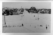
Photograph shows an aerial view of the Medicine Hat Exhibition and Stampede Parade route, with a focus on Second Street SE. A residential area showing homes with extensive backyard gardens can be seen. The South Saskatchewan River can be see on the right of the photograph.
Notes
This photograph shows the neighbourhood before rezoning and commercial development.
Name Access
Medicine Hat
South Saskatchewan River
Subject Access
parades
floats
aerial photography
aerial views
street scenes
gardens
Repro Restriction
Subject to Canadian Copyright Law
Storage Location
RG 5 photograph storage drawer 2 (hanging photos)
Arrangement
BR #3 Family photos
Images
Show Less

Atkinson site 2004 - east wall of XU 1 and 2

http://archives.brandonu.ca/en/permalink/descriptions12213
Part Of
RG 7 Beverley Nicholson fonds
Description Level
Item
GMD
graphic
Date Range
2004
Accession Number
1-2010
Part Of
RG 7 Beverley Nicholson fonds
Description Level
Item
Series Number
2.1.2.5
Item Number
2.1.2.5.8
Accession Number
1-2010
GMD
graphic
Date Range
2004
Physical Description
1024 x 768 (416 KB)
Material Details
JPEG
History / Biographical
Photograph taken during 2004 Brandon University Archaeology excavations at Atkinson site.
Scope and Content
Excavation units 1 and 2, east wall.
Name Access
Atkinson site 2004 - east wall of XU 1 and 2
Subject Access
Archaeology North lauder locale Atkinson site DiMe-27 Atkinson site 2004 photographs
Images
Show Less

Church, Smart, Manitoba (2 miles north, 1 mile east of)

http://archives.brandonu.ca/en/permalink/descriptions11412
Part Of
RG 11 Lawrence Stuckey fonds
Description Level
Item
GMD
graphic
Date Range
December 19, 1978; August 4, 1979
Accession Number
1-2002
Part Of
RG 11 Lawrence Stuckey fonds
Creator
L.A. Stuckey
Description Level
Item
Series Number
3.3
Item Number
1-2002.3.3.CNR[149b]
Accession Number
1-2002
GMD
graphic
Date Range
December 19, 1978; August 4, 1979
Physical Description
2.25" x 2.25" (b/w)
Material Details
Negative
History / Biographical
Stuckey's notes: St. George's, Elton district, built 1901.
Custodial History
For custodial history see the collection level description of the Lawrence Stuckey collection.
Scope and Content
Image of a church at Smart, Manitoba (2 miles north, 1 mile east), taken along the CNR mainline, Rivers substation.
Name Access
CNR
Smart, Manitoba
Subject Access
railways
Church buildings/Churches
Repro Restriction
The McKee Archives is the copyright holder of the Stuckey materials.
Storage Location
Lawrence Stuckey collection
Arrangement
[Mr. Stuckey put three negatives in same envelope. We have separated them and numbered them (149a) to (149c)].
Images
Show Less

Flintstone Hill 1998-2000 - Test Unit 1 east profile

http://archives.brandonu.ca/en/permalink/descriptions12316
Part Of
RG 7 Beverley Nicholson fonds
Description Level
Item
GMD
graphic
Date Range
1998-2000
Accession Number
1-2010
Part Of
RG 7 Beverley Nicholson fonds
Description Level
Item
Series Number
2.2.2.5
Item Number
2.2.2.5.3
Accession Number
1-2010
GMD
graphic
Date Range
1998-2000
Physical Description
549 x 775(226)
Material Details
JPEG
History / Biographical
Photograph taken during 1998-2000 Brandon University Archaeology survey at Flintstone Hill.
Scope and Content
Test Unit 1 east profile.
Name Access
Flintstone Hill 1998-2000 - Test Unit 1 east profile
Subject Access
Archaeology North lauder locale Flintstone Hill DiMe-26 Flintstone Hill 1998-2000 - Test Unit 1 east profile
Images
Show Less

Graham site 2005 - Bone bed XU 1, 2 & 3

http://archives.brandonu.ca/en/permalink/descriptions11921
Part Of
RG 7 Beverley Nicholson fonds
Description Level
Item
GMD
graphic
Date Range
2005
Accession Number
1-2010
Part Of
RG 7 Beverley Nicholson fonds
Description Level
Item
Series Number
1.4.2.5
Item Number
5
Accession Number
1-2010
GMD
graphic
Date Range
2005
Physical Description
2,750 x 2,063 (1,261 KB )
Material Details
JPEG
Scope and Content
Bone bed from excavation units 1, 2 & 3 level 8
Name Access
Graham site 2005 - Bone bed XU 1, 2 & 3
Subject Access
Archaeology Crepeele locale Graham site 2005 Graham site 2005 - photographs
Images
Show Less

Church, Smart, Manitoba (2 miles north, 1 mile east of)

http://archives.brandonu.ca/en/permalink/descriptions10454
Part Of
RG 11 Lawrence Stuckey fonds
Description Level
Item
GMD
graphic
Date Range
December 19, 1978; August 4, 1979
Accession Number
1-2002
Part Of
RG 11 Lawrence Stuckey fonds
Creator
L.A. Stuckey
Description Level
Item
Series Number
3.3
Item Number
1-2002.3.3.CNR[149a]
Accession Number
1-2002
GMD
graphic
Date Range
December 19, 1978; August 4, 1979
Physical Description
2.25" x 2.25" (b/w)
Material Details
Negative
History / Biographical
Stuckey's notes: St. George's, Elton district, built 1901.
Custodial History
For custodial history see the collection level description of the Lawrence Stuckey collection.
Scope and Content
Image of a church at Smart, Manitoba (2 miles north, 1 mile east), taken along the CNR mainline, Rivers substation.
Name Access
CNR
Smart, Manitoba
Subject Access
railways
Church buildings/Churches
Repro Restriction
The McKee Archives is the copyright holder of the Stuckey materials.
Storage Location
Lawrence Stuckey collection
Arrangement
[Mr. Stuckey put three negatives in same envelope. We have separated them and numbered them (149a) to (149c)].
Images
Show Less

Church, Smart, Manitoba (2 miles north, 1 mile east of)

http://archives.brandonu.ca/en/permalink/descriptions10455
Part Of
RG 11 Lawrence Stuckey fonds
Description Level
Item
GMD
graphic
Date Range
December 19, 1978; August 4, 1979
Accession Number
1-2002
Part Of
RG 11 Lawrence Stuckey fonds
Creator
L.A. Stuckey
Description Level
Item
Series Number
3.3
Item Number
1-2002.3.3.CNR[149c]
Accession Number
1-2002
GMD
graphic
Date Range
December 19, 1978; August 4, 1979
Physical Description
2.25" x 2.25" (b/w)
Material Details
Negative
History / Biographical
Stuckey's notes: St. George's, Elton district, built 1901.
Custodial History
For custodial history see the collection level description of the Lawrence Stuckey collection.
Scope and Content
Image of a church at Smart, Manitoba (2 miles north, 1 mile east), taken along the CNR mainline, Rivers substation.
Name Access
CNR
Smart, Manitoba
Subject Access
railways
Church buildings/Churches
Repro Restriction
The McKee Archives is the copyright holder of the Stuckey materials.
Storage Location
Lawrence Stuckey collection
Arrangement
[Mr. Stuckey put three negatives in same envelope. We have separated them and numbered them (149a) to (149c)].
Images
Show Less

Old barn and windmill stand, 1 mile east of Newdale, Manitoba

http://archives.brandonu.ca/en/permalink/descriptions10740
Part Of
RG 11 Lawrence Stuckey fonds
Description Level
Item
GMD
graphic
Date Range
June 26, 1979
Accession Number
1-2002
Part Of
RG 11 Lawrence Stuckey fonds
Creator
L.A. Stuckey
Description Level
Item
Series Number
3.3
Item Number
1-2002.3.3.BNW[275.0a]
Accession Number
1-2002
GMD
graphic
Date Range
June 26, 1979
Physical Description
2.25" x 2.25" (b/w)
Material Details
Negative
Custodial History
For custodial history see the collection level description of the Lawrence Stuckey collection.
Scope and Content
Image of an old barn and windmill stand, 1 mile east of Newdale, Manitoba.
Notes
[Brandon NW includes communities north of Trans-Canada #1 highway and west of PTH #10.]
Name Access
Newdale, Manitoba
Subject Access
barns
manmade geographic features
Repro Restriction
The McKee Archives is the copyright holder of the Stuckey materials.
Storage Location
Lawrence Stuckey collection
Arrangement
[Mr. Stuckey put two negatives in same envelope. We have separated them and numbered them (275.0a) to (275.0b)].
Images
Show Less

Old barn and windmill stand, 1 mile east of Newdale, Manitoba

http://archives.brandonu.ca/en/permalink/descriptions10742
Part Of
RG 11 Lawrence Stuckey fonds
Description Level
Item
GMD
graphic
Date Range
June 26, 1979
Accession Number
1-2002
Part Of
RG 11 Lawrence Stuckey fonds
Creator
L.A. Stuckey
Description Level
Item
Series Number
3.3
Item Number
1-2002.3.3.BNW[275.0b]
Accession Number
1-2002
GMD
graphic
Date Range
June 26, 1979
Physical Description
2.25" x 2.25" (b/w)
Material Details
Negative
Custodial History
For custodial history see the collection level description of the Lawrence Stuckey collection.
Scope and Content
Image of an old barn and windmill stand, 1 mile east of Newdale, Manitoba.
Notes
[Brandon NW includes communities north of Trans-Canada #1 highway and west of PTH #10.]
Name Access
Newdale, Manitoba
Subject Access
barns
manmade geographic features
Repro Restriction
The McKee Archives is the copyright holder of the Stuckey materials.
Storage Location
Lawrence Stuckey collection
Arrangement
[Mr. Stuckey put two negatives in same envelope. We have separated them and numbered them (275.0a) to (275.0b)].
Images
Show Less

Christmas Tree Farm negative set 1, frames 0 to 26

http://archives.brandonu.ca/en/permalink/descriptions14180
Part Of
Fred McGuinness collection
Description Level
Item
GMD
graphic
Date Range
[1980s-1990s]
Accession Number
1-2015
Part Of
Fred McGuinness collection
Description Level
Item
Series Number
McG 9
Item Number
1-2015.249
Accession Number
1-2015
GMD
graphic
Date Range
[1980s-1990s]
Physical Description
1.5" x 1.5" (b/w)
Material Details
negatives
History / Biographical
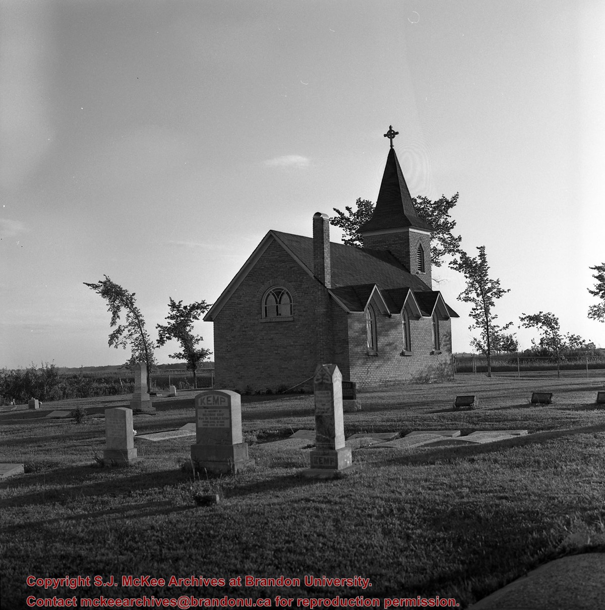
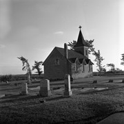
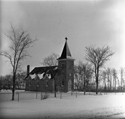
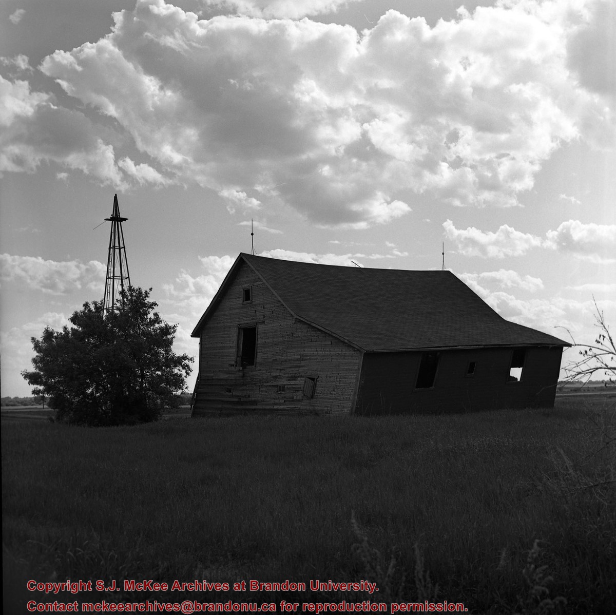
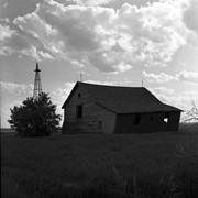
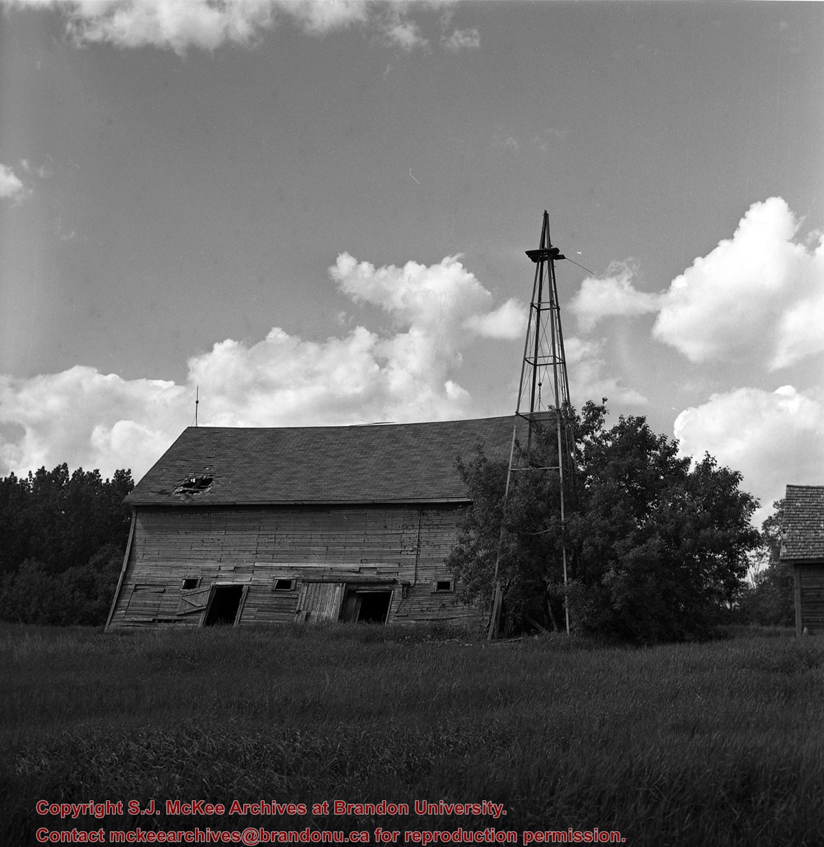
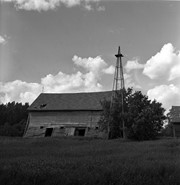
Fred McGuinness is popularly known for his work as the prairie essayist for CBC Radio’s Morningside with Peter Gzowski, a position he held for 17 years. Many of McGuinness’ Morningside essays were autobiographical in nature. He often reported about life on Christmas Tree Farm, a section of land where he and his wife, Christine, built their dream home in the late 1970s. The couple planted a Christmas tree farm on the property and Christine maintained an extensive kitchen garden, while Fred tended honey bees. Life on the farm made its way into radiobroadcasts, Neighborly News columns, and the book "Letters from Section 17: A Collection of Morningside Essays" (Winnipeg: Great Plains Publishing, 1999).
Scope and Content
Set consists of 27 negatives showing different views of the McGuinness property, Christmas Tree Farm, Section 17
Name Access
Christmas Tree Farm
Section 17
Subject Access
residences
farms
trees
Storage Location
RG 5 photograph storage drawer 2 (hanging photos)
Arrangement
RR #8 photos
Images
Show Less

Lorne Avenue in winter

http://archives.brandonu.ca/en/permalink/descriptions10114
Part Of
RG 12 Brandon and Area Photograph Collection
Description Level
Item
GMD
graphic
Date Range
c. 1905
Part Of
RG 12 Brandon and Area Photograph Collection
Description Level
Item
Series Number
2
Item Number
BAPC 2.1
GMD
graphic
Date Range
c. 1905
Physical Description
4" x 6" (b/w)
Scope and Content
Photograph is looking east down Lorne Avenue from Brandon College.
Name Access
Lorne Avenue
18th Street
Park School
Subject Access
cityscapes
winter
Storage Location
BAPC photograph drawer
Images
Show Less

Hunter with antelope

http://archives.brandonu.ca/en/permalink/descriptions13806
Part Of
Fred McGuinness collection
Description Level
Item
GMD
graphic
Date Range
1955-1965
Accession Number
20-2009
Part Of
Fred McGuinness collection
Description Level
Item
Series Number
McG 9
Item Number
20-2009.116
Accession Number
20-2009
GMD
graphic
Date Range
1955-1965
Physical Description
3.5" x 3" (b/w)
Scope and Content
Photograph shows a hunter in a valley posing with his antelope kill.
Notes
Photograph is part of series of photographs (20-2009.13 to 20-2009.124) of an antelope hunting trip that likely occurred in Alberta.
Subject Access
hunting
winter
Storage Location
RG 5 photograph storage drawer 2 (hanging photos)
Arrangement
Originally stored in McG 20-2009 #4 plastic envelope #3
Images
Show Less
Part Of
Fred McGuinness collection
Description Level
Item
GMD
graphic
Date Range
1955-1965
Accession Number
20-2009
Part Of
Fred McGuinness collection
Description Level
Item
Series Number
McG 9
Item Number
20-2009.117
Accession Number
20-2009
GMD
graphic
Date Range
1955-1965
Physical Description
3.5" x 3" (b/w)
Scope and Content
Photograph shows a hunter inside a hunting cabin. The hunter is holding his rifle and wearing a cap and heavy-knit sweater.
Notes
Photograph is part of series of photographs (20-2009.13 to 20-2009.124) of an antelope hunting trip that likely occurred in Alberta.
Subject Access
hunting
winter
Storage Location
RG 5 photograph storage drawer 2 (hanging photos)
Arrangement
Originally stored in McG 20-2009 #4 plastic envelope #3
Images
Show Less

20 records – page 5 of 1.