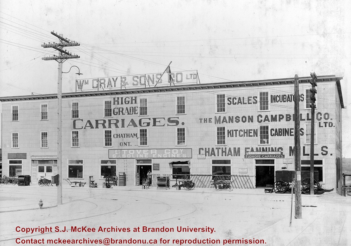
In the period leading up to World War I, Brandon, due to its excellent railway connections, was also home to branch offices of a number of large manufacturing companies during this period. Among those manufacturing outfits were William Gray & Sons Co. Ltd., and Mason Campbell Company. Based in Chatham, ON, these companies were leading manufacturers of carriages, sleighs and light wagons and fanning mills respectively. Constructed in 1907, by Giddings and Wyman for approximately $15,000, the four-storey structure was located at 801 Pacific Avenue and was shared by the two companies.
In response to the new technology of the gasoline engine, Wm. Gray & Sons entered into a partnership with the Dort Motor Company, of Flint, MI in 1915, and began designing and producing the Gray-Dort automobile; Mason Campbell’s Chatham plant became the assembly plant for the Gray-Dort. Production of the car spanned nearly ten years with over 20,000 Gray Dorts made. The company had over 300 dealers across the country, including one in Brandon.
In 1924, the Dort Motor Company decided to cease production, sending the Gray Company into significant debt. They were forced to close their doors in 1925, when Gray was unable to find a suitable partner to manufacture the car.
Following the closure of Gray-Campbell Ltd., portions of the warehouse were used by a number of businesses between 1925 - 1948, including farm and agricultural implement concerns Canadian Stover Co., Cameron & Rathwell, and Case (J.I.) Co. Ltd., the McKay Fruit Co. Ltd., Brazzell Motors, AC Bateman (electrician), Samuel Coxe (veterinarian) and Burns & Co. Ltd (packing house and egg grading station).
In 1949, the warehouse was taken over by Canada Grocers Ltd., who remained until 1973, when the building became Kullberg’s Big Warehouse. When Kullberg’s moved their warehouse to the old International Harvester building in 2004, the Wm. Gray & Sons Co. Ltd. building was torn down.
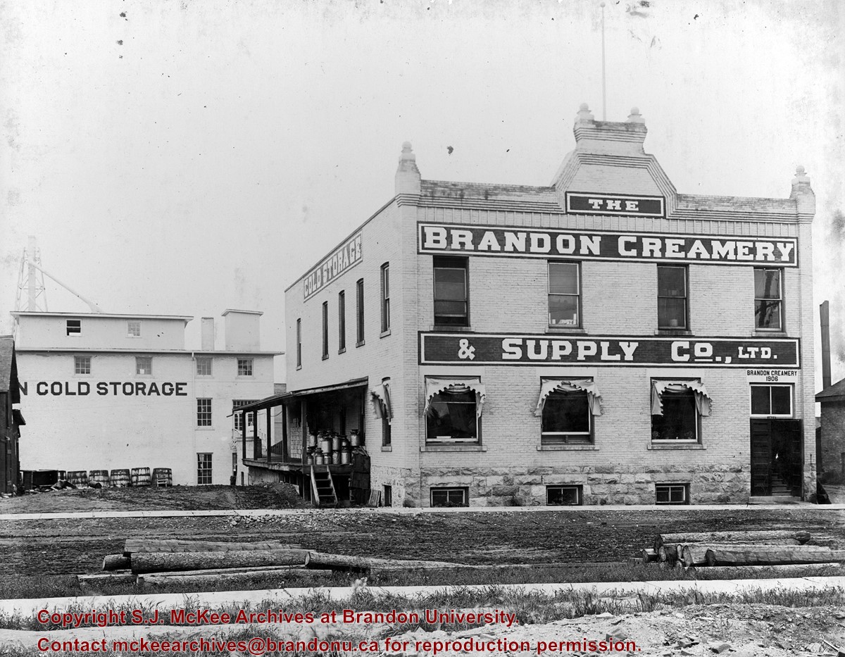
Custodial History
See fonds level description of the Alf Fowler collection for custodial history.
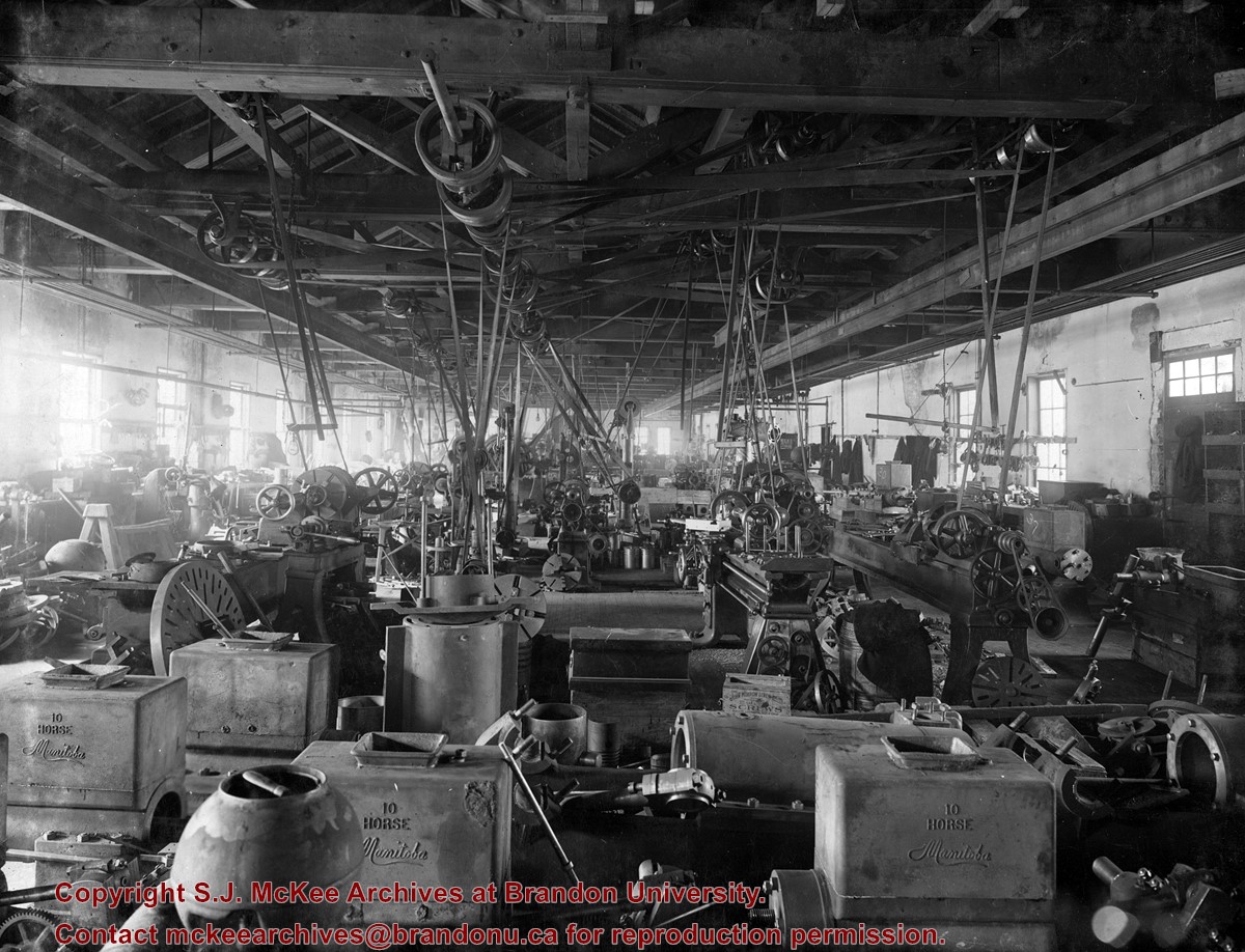
Scope and Content
Photo shows the front of William Gray & Sons Co. Ltd. Wording and signs on the bulding include: "High Grade Carriages, Chatham, Ont."; "Scales"; "Incubators"; "The Manson Campbell Co. Ltd."; "Kitchen Cabinets"; "Chatham Fanning Mills"; "Emerson (New Standard) Mowers"; "Tudhope Carriages"; "Agency for Sylvester Drills"; "Stover Coy Gasoline Engines"; "Gray-Campbell, High Grade Carriages"; and "Phone 771."
Storage Range
RG 5 Western Manitoba Manuscript collection - photograph storage drawer
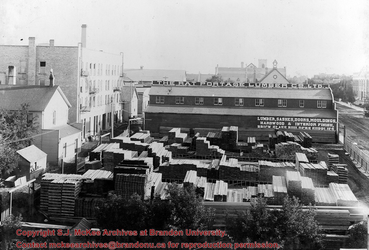
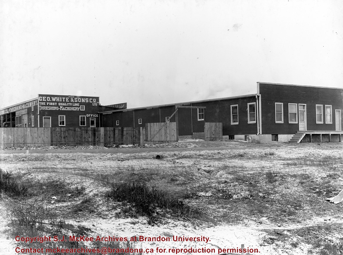
The Rat Portage Lumber Company Ltd. was located on 10th Street at the corner of Princess Avenue.
Custodial History
See fonds level description of the Alf Fowler collection for custodial history.
Scope and Content
Photo shows premises of The Rat Portage Lumber Co. Ltd. - lumber, sashes, doors, mouldings, hardwood & interior finish, brick, glass, builders supplies. The view is south along 11th Street.
Storage Range
RG 5 Western Manitoba Manuscript collection - photograph storage drawer
View is northwest from Clark Hall. Photograph shows construction materials in the area between Clark Hall and the A.E. McKenzie Building during winter. The Western Manitoba Centennial Auditorium is visible in the upper right hand corner.
View is south southeast from the skywalk. Photograph shows the courtyard in winter full of vehicles, machines and building materials. Also visible are the Development and Physical Plant H-Huts, the Citizens' Science Building, the John R. Brodie Science Centre and McMaster Hall.
View is northwest from the roof of the Brandon College Building. Photograph was taken through wire fencing and shows construction on the roof of the Brandon College Building during winter. The original Clark Hall entrance to the roof is clearly visible. Portions of the A.E. McKenzie Building, Clark Hall and the Western Manitoba Centennial Auditorium are visible in the background.
Photograph was taken from the skywalk and shows students leaving the George T. Richardson Centre during winter. The courtyard contains construction materials. The Physical Plant H-Hut and McMaster Hall are partially visible in the background.
Photograph shows the removal of one of the houses formerly located on 20th Street between Louise and Princess Avenues. The houses on those blocks were removed to create parking lots for the University. A Fed Zavislak Ltd. Well Drilling & Trucking pickup truck is visible at the curb.
Photograph shows the removal of one of the houses formerly located on 20th Street between Louise and Princess Avenues. The houses on those blocks were removed to create parking lots for the University.
View is northeast from the Brandon College Building. Photograph shows the inside of the Brandon College Building after it had been gutted and then partially rebuilt. The exterior fascade of the west side of the building can be clearly seen in this photograph. A number of houses on the east side of 200 block of 18th Street are also visible, as is the stone fence on Princess Avenue and the flag pole on the front lawn.
View is southwest from approximatley 16th Street between Princess and Rosser Avenues. Photograph shows the Brandon University campus, as well as surrounding residential blocks, including Flemming, J.R. Reid and Vincent Massey schools.
View is west southwest from approximatley 16th Street between Princess and Lorne Avenues. Photograph shows the Brandon University campus, as well as surrounding residential blocks between 16th and 23rd Streets, Princess and Louise Avenues..
View is west from approximatley 17th Street between Lorne and Louise Avenues. Photograph shows a portion of the Brandon University campus (excluding the Education Building and anything north of it), as well as surrounding residential blocks from approximatley 17th Street to 22nd Street.
View is west northwest from approximatley 16th Street and Louise Avenue. Photograph shows the Brandon University campus, prior to the Library Extension, and a large portion of the city to the west of the campus.
View is northwest from approximatley 16th Street and Louise Avenue. Photograph shows the Brandon University campus, prior to the Library Extension, and a large portion of the city to the west of the campus.
View is northeast probably from the roof of McMaster Hall. Photograph shows the construction of the new roof on Clark Hall and the Brandon College Building. A portion of the east side of the 000 and 100 blocks of 18th Street, as well as the corner of 18th Street and Rosser Avenue are visible in the upper left hand corner. This includes the "Downtown Brandon" sign.
View is north northeast probably from the roof of McMaster Hall. Photograph shows the construction of the new roof on Clark Hall and the Brandon College Building, as well as the construction of the extension to Clark Hall and the skywalk. Portions of the city as far north as the Assiniboine River are also visible.


