Photograph shows the north face of the Prince Edward Hotel on Princess Avenue. To the east of the hotel is Old City Hall with the military monument (which has since been relocated to the Brandon Armoury). On the west side of the hotel is Wheelers Esso Service Station.
Notes
The photograph appears to be taken from the Hughes Building on 10th Street.
Photograph shows the exterior of the Winter Fair Arena on 10th Street.
Notes
Part of "Souvenir of Brandon, Manitoba, Canada [viewbook], Printed by Photogelatine Engraving Co. Limited, Ottawa." Dates obtained from the Burchill's Music Store Henderson's Brandon City Directory listings (1927-1929). Writing on the front of the photograph reads: Winter Fair Arena, Brandon, Man.
Photograph shows a southwestern view of Clark Hall and the Brandon College Original Building. The Citizen Science Building is absent from the campus grounds.
Notes
Part of "Souvenir of Brandon, Manitoba, Canada [viewbook], Printed by Photogelatine Engraving Co. Limited, Ottawa." Dates obtained from the Burchill's Music Store Henderson's Brandon City Directory listings (1927-1929). Writing on the front of the photograph reads: Brandon College, Brandon, Man.
Photograph shows two separate views. One is of the main entrance of (Old) City Hall on Princess Avenue. The other view shows the ediface of the YMCA building as well as the adjacent St. Paul's United and First United Churches on 8th Street.
Notes
Part of "Souvenir of Brandon, Manitoba, Canada [viewbook], Printed by Photogelatine Engraving Co. Limited, Ottawa." Dates obtained from the Burchill's Music Store Henderson's Brandon City Directory listings (1927-1929). Writing on the front of the photograph reads: City Hall - Brandon, Man; YMCA, St. Paul's United & First Church United, Brandon, Man.
Photograph shows the intersection of 10th Street and Princess Avenue, Brandon, Manitoba. View is facing northwest along west side of the 100-block of 10th Street. A stationary policeman/divider is at the centre of the intersection. Visible businesses include: Doig's, Plaza Shoe Shop, and Cambridge Clothes Shop. A horse-drawn sled is parked in front of Doig's store. The Olympia Block, Cecil Hotel, and CPR Station are visible in the background.
Left hand corner of mat is bent. Mock-up instructions are written in pencil at the bottom right hand corner. Portions of the photograph itself are marked with pen.
History / Biographical
The Queen's Hotel was located on the corner of Rosser Avenue and Tenth Street (Steen & Boyce, 1882. Brandon, Manitoba, Canada and Her Industries. Steen & Boyce Publishers Printers & Binders, 81.). Therefore this photo appears to display Rosser Avenue looking east. P.E. 11/06/09
Scope and Content
Photograph shows early Rosser Avenue under construction between 9th Street and 10th Street in the 1880s. Buildings that line the avenue are wood framed and there are wooden boardwalks in front of a few structures. On the north side of Rosser Avenue signs for Fortier & Bucke Commision Agents and Transit House (Hotel) can be seen. On the south side of Rosser Avenue, the Queen's Hotel and Robinson Brothers and Company groceries and dry goods store are open for business. A family appears to be standing on the stoop at the dry goods store. A boy is lounging in the entryway of the Queen's Hotel. A man is standing on a wooden plank that extends across the dirt road of Rosser Avenue between the dry goods store and the commission agents' shop.
Photograph shows Princess Avenue facing east from 10th Street. On the north side of Princess Avenue, a B/A Service Station, Princess Cafe, Lindenberg Seeds, and the Central Fire Station are visible. Old City Hall with the war memorial and the Prince Edward Hotel are visible on the south side of Princess Avenue. Traffic is travelling one-way on Princess Avenue.
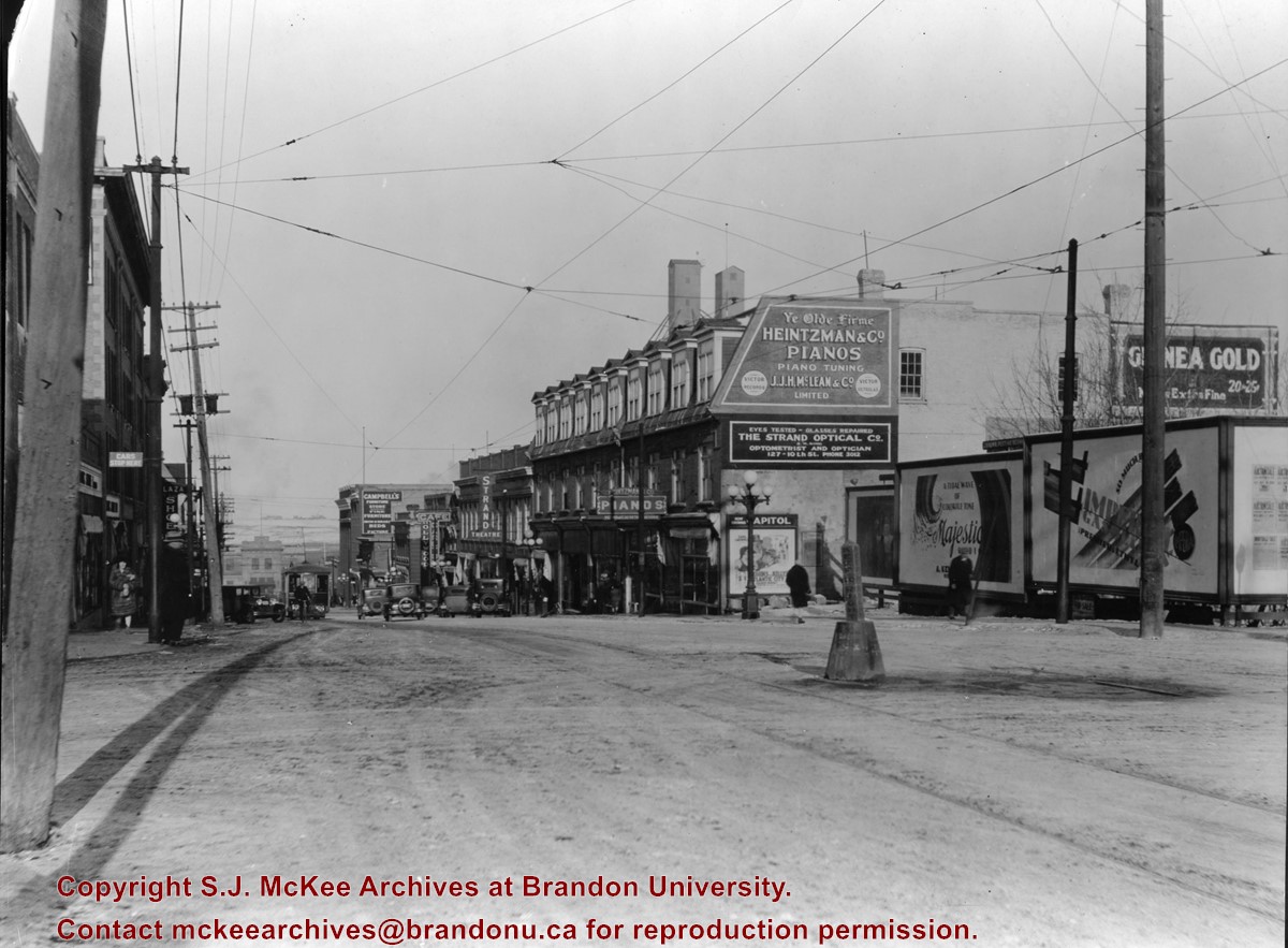
Photograph shows the intersection of 10th Street and Princess Avenue looking northeast. A stationary policeman/divider is situated in the centre of the intersection. The lot on the corner appears to be for sale and a solid wooden fence has several advertisements, including for: Majestic Radio and a production by the Brandon Operatic Society at City Hall for "A Runaway Girl."
The Brown Block has a third storey lined with dormer windows. Advertisements for Heintzamn & Co. Pianos Piano Tuning, J.J.H. McLean & Co. Ltd, and The Strand Optical Co. are painted on the south side of the Brown Block. Also present is an advertising board for the Capitol Theatre. Signs for the Strand Theatre, Hollywood Cafe, and Campbell's Furniture are also visible.
Notes
Photograph date obtained from the presence of the Hollywood Cafe in the 1929 Henderson's Brandon City Directory and the performance by the Brandon Operatic Society.
Photograph shows the intersection of 10th Street and Princess Avenue facing northeast. A stationary policeman/divider is situated in the centre of the intersection. A street car is travelling south on 10th Street. Angled parking is on both sides of the street.
The lot on the northeast corner appears to be for sale and a solid wooden fence has several advertisements, including for: Majestic Radio, Imperial Gasoline (premier and ethyl), and a production a City Hall for "A Runaway Girl."
The Brown Block has a third storey lined with dormer windows. Advertisements for Heintzamn & Co. Pianos Piano Tuning, J.J.H. McLean & Co. Ltd, and The Strand Optical Co. are painted on the south side of the Brown Block. Also present is an advertising board for the Capitol Theatre on which is a poster for "Cohens and Kellys in Atlantic City." Signs for the Strand Theatre, Hollywood Cafe, and Campbell's Furniture are also visible.
A sign for Plaza Shoes can be seen on the west side of 10th Street. The train station can be seen at the base of the hill.
Notes
Photograph date based on the Capitol's film "Cohens and Kellys in Atlantic City" that was advertised in the Brandon Daily Sun 03 December 1929
Postcard shows an aerial view of 9th Street facing south in Brandon, Manitoba. Visible businesses and landmarks include: Beaubier Hotel, YMCA/police station, the original CKX Radio station towers on 8th Street (est. 1928 - moved 1940), the old City Hall, Prince Edward Hotel, and the original Manitoba Power commission smokestack on 10th Street.
Notes
Writing on the front of the photograph reads: Brandon, Man., Jerrett Photo. This photograph shows a rare view of the 800-block between Rosser and Princess Avenues.
Photograph shows exterior views of five Brandon churches: Baptist Church, Presbyterian Church, St. Matthew's Church, Catholic Church and Monastery, and Methodist Church.
Notes
Part of "Christie's Brandon Series of Six Colored Picture Postcards of Brandon, Manitoba, The Crown Series, Published by Christie's Bookstore, Brandon, Man." [note: missing sixth postcard]. Writing on the front of the photograph reads: Baptist Church, Presbyterian Church Brandon Man., St. Matthew's Church, Catholic Church and Monastery, Methodist Church.
Photograph shows the Greyhound Bus Depot at 11th Street and Princess Avenue. Western Motors, Wheelers Esso Station, and the Prince Edward Hotel are visible along the south side of Princess Avenue. Traffic is travelling one-way on Princess Avenue.
Red ink stain is on the front right corner of postcard
Scope and Content
Photograph shows 10th Street facing south from Princess Avenue. Visible landmarks and businesses include: Manitoba Power Commission (MPC)'s power sub-station, First Baptist Church, Wheat City Arena, and the grand stand at the Exhibition Grounds.
The partial sign visible at the bottom of the photograph on the east side of 10th Street reads Yates and Neale, which refers to a plumbing and heating company that dissolved in 1943 to be replaced by Neale, Stothard and Chapman.
Businesses on the west side of 10th Street include: Dominion Tire & Radio Co., Bolts Barber Shop, Elviss T.E. Co. Stables.
Notes
Information concerning Yates and Neale courtesy Jack Stothard. Writing on the front of the postcard reads: Brandon, Looking S.W., Jerrett Photo. This photograph shows a rare view of the 200-block of 10th Street.
Photograph of the northeast corner of 10th Street and Princess Avenue facing northeast. An Imperial Esso Dealer is situated on the southeast corner. On the northeast side the following businesses are visible: Thunderbird Bowl, Canadian Pacific Telegraphs, Pittsburgh Paint & Glass, The Strand Theatre, Trans Canada Credit Loans, Ted Heming Jewellers, Carlton Cafe, Barclay Shoe Store, Chamber of Commerce, United Cafe, and Chop Suey. An billboard for 2 Way drink is mounted on the former Campbell's Furniture Building. A sign for the Manitoba CAA Motor League hangs from a business on the southwest corner of 10th Street and Princess Avenue. Traffic on Princess Avenue, on the east side of 10th Street, is travelling one-way.
Photograph of the northeast corner of 10th Street and Princess Avenue facing northeast. An Imperial Esso Dealer is situated on the southeast corner. On the northeast side the following businesses are visible: Thunderbird Bowl, Canadian Pacific Telegraphs, Pittsburgh Paint & Glass, The Strand Theatre, Trans Canada Credit Loans, Ted Heming Jewellers, Carlton Cafe, Barclay Shoe Store, Chamber of Commerce, United Cafe, and Chop Suey. An billboard for 2 Way drink is mounted on the former Campbell's Furniture Building. A sign for the Manitoba CAA Motor League hangs from a business on the southwest corner of 10th Street and Princess Avenue. Traffic on Princess Avenue, on the east side of 10th Street, is travelling one-way.
Photograph shows Ted Heming Jewellers on the east side of 10th Street, Brandon, Manitoba, with the Strand Theatre to the south of the building complex. Other visible businesses in the Strand Block include: Hughes & Co. Ltd., Smart's Stationery, Waddell's, and Metropolitan Life.
Notes
Photograph dated from "Gidget," the movie playing at the Strand Theatre
Photograph shows the Strand Block on the east side of 10th Street, Brandon, Manitoba. Visible businesses in the Strand Block include: Hughes & Co. Ltd., Smart's Stationery, Waddell's, the Strand Theatre, and Metropolitan Life.
Notes
Back of the photograph is stamped: Clark Smith Studio, per July 27/59
Photograph of east side of 10th Street, Brandon, Manitoba, between Rosser and Princess Avenues. Visible businesses include: The Bank of Montreal, Barclay's Shoe Store, Carlton Cafe (in the former Cigar Factory), and Ted Heming Jewellers. The McKenzie Seed building is visible in the background.
Photograph shows the east side of 10th Street, Brandon, Manitoba, between Rosser and Princess Avenues. Businesses visible in the Brown Block include (from north to south): Singer, Pittsburgh Paint & Glass, O. Stark & Son, Elna Sewing Centre, and Canadian Pacific Telegraphs. The Prince Edward Hotel is visible in the background.
Doig's, originally located on Rosser Avenue, moved to the 10th Street location in 1921.
Scope and Content
Photograph of west side of 10th Street, Brandon, Manitoba, facing northwest. Visible businesses in the Alexander Block include Doig's, Box Brothers Hardware and Allied Hardware Stores, followed by Simpsons-Sears and Barry Neill Men's Wear in the Strathcona Block. The Johnny Smith Block is visible in the background.


