Postcard shows an exterior view of the Twin Pines Motel
Notes
Writing on the back of the postcard reads: Twin Pines Motel & Restaurant / Brandon, Manitoba, Canada / Located at 10th Street & Queens Avenue / 40 Fully modern units with bath & showers, T. / Kichenettes, winter plug-ins, Ample parking. / For reservations call.... / 30717-C Color Photo by Joe Fartak / Color Productions Ltd., Box 1243, Regina, Sask.
The postcard is addressed to Mr. F.A. Rosser and is postmarked Brandon 06 June 1970. A 6-cent Queen Elizabeth red postage stamp portraying various modes of the transportation.
Photographs have been glued to a backing board that has warped over time
History / Biographical
Photograph of possible Dakota from Sioux Valley in Brandon for the summer fair.
Scope and Content
Photograph shows street view of north side of Rosser Avenue, primarily the 700 block. Businesses visible in the Fleming Block include: Lowes Brothers Clothing, Robert Hall [Insurance Broker], Manitoba Farmers Hedge and Wire Fence Company. Businesses visible in the Beaubier Block include the Empire Hotel. Businesses east of the Empire Hotel are grocer A.M. Percival and the Brandon Hardware Company. A number of Aboriginal peoples are travelling on horseback west along Rosser Avenue as spectators look on.
Notes
Writing on the front of the photograph matting reads: 293. One photograph (20-2009.9) is glued above and two others are glued on the reverse side. Page appears to be from a photo album.
Photographs have been glued to a backing board that has warped over time
History / Biographical
Photograph of possible Dakota from Sioux Valley in Brandon for the summer fair.
Scope and Content
Photograph shows street view of north side of Rosser Avenue, primarily the 700 block. Businesses visible in the Beaubier Block include the Empire Hotel. Businesses east of the Empire Hotel are grocer A.M. Percival, the Brandon Hardware Company, and the Arlington Hotel. A number of Aboriginal peoples are driving horse and buggies east along Rosser Avenue as large numbers of spectators look on.
Notes
Writing on the front of the photograph matting reads: 298. One photograph (20-2009.79) is glued above, another (20-2009.81) adjacent. One other is glued on the reverse side. Page appears to be from a photo album.
Photographs have been glued to a backing board that has warped over time
History / Biographical
Photograph of possible Dakota from Sioux Valley in Brandon for the summer fair.
Scope and Content
Photograph shows street view of north side of Rosser Avenue, primarily the 700 block. Businesses visible in the Fleming Block include: Lowes Brothers Clothing, Robert Hall [Insurance Broker], Manitoba Farmers Hedge and Wire Fence Company. Businesses visible in the Beaubier Block include the Empire Hotel. Businesses east of the Empire Hotel are grocer A.M. Percival and the Brandon Hardware Company. A number of Aboriginal peoples are driving horse and carriages west along Rosser Avenue as spectators look on.
Notes
Writing on the front of the photograph matting reads: 295 July 1906. One photograph (20-2009.11) is glued above and two others are glued on the reverse side. Page appears to be from a photo album.
Photographs have been glued to a backing board that has warped over time
Scope and Content
Photograph shows street view of north side of Rosser Avenue, primarily the 700 block. The Fleming Block, Beaubier Block and its Empire Hotel, A.M. Percival (a grocer), the Brandon Hardware Company (600 block), and the Arlington Hotel (500 block) are visible along the north side of the avenue. The Bank of Hamilton Building on the southeast corner of 8th Street and Rosser appears to be under construction. A sign in the second storey window above the main entrance reads: law office. The streets are muddy and a horse and buggy is traveling west on Rosser Avenue.
Notes
Writing on the front of the photograph matting reads: mud November 12, 1906, 339. The photograph appears to be taken from the interior of a builing on the southwest corner of 8th Street and Rosser Avenue. Page appears to be from a photo album.
Photographs have been glued to a backing board that has warped over time
History / Biographical
Photograph of possible Dakota from Sioux Valley in Brandon for the summer fair.
Scope and Content
Photograph shows street view of north side of Rosser Avenue, primarily the 700 block. Businesses visible in the Fleming Block include: Lowes Brothers Clothing, Robert Hall [Insurance Broker], Manitoba Farmers Hedge and Wire Fence Company. Businesses visible in the Beaubier Block include the Empire Hotel. Businesses east of the Empire Hotel are grocer A.M. Percival and the Brandon Hardware Company. A number of Aboriginal peoples are driving horse and buggies west along Rosser Avenue as spectators look on.
Notes
Writing on the front of the photograph matting reads: 294 July 1906. One photograph (20-2009.10) is glued below and two others are glued on the reverse side. Page appears to be from a photo album.
Photograph exfoliated on edges where masking tape has been removed.
History / Biographical
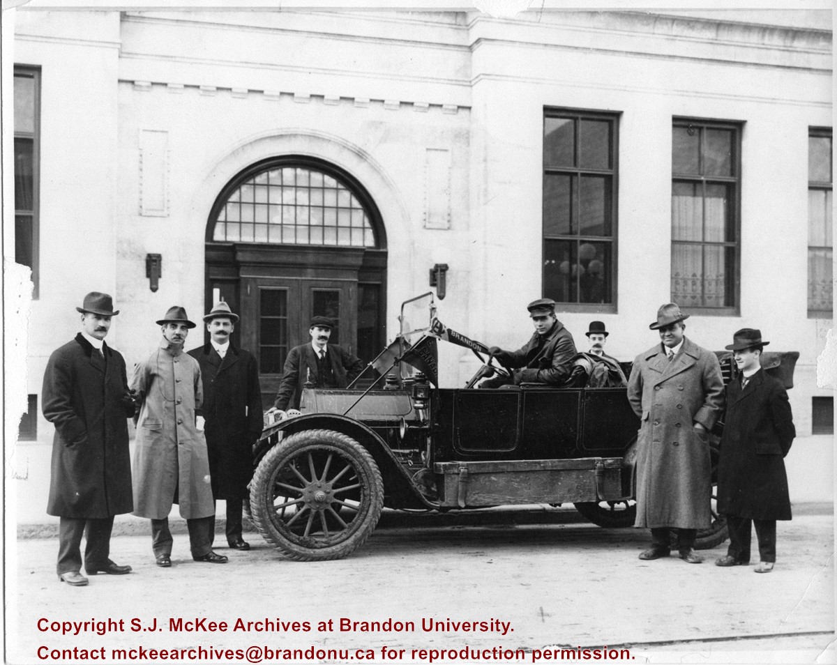
In 1912, the Brandon Daily Sun (30 September 1912) published an article about the 7th Annual Meeting of the Manitoba Association of Architects that was held at the Prince Edward Hotel on September 28. It was the first time that the association held an annual meeting outside of Winnipeg. Local architect W.A. Elliott was elected first vice president of the assocation. As part of the meeting's entertainment, the Brandon Automobile Club provided excursions around the city, making special stops at the fair grounds, industrial school, new asylum buildings, and the experimental farm.
Scope and Content
Photograph shows a group of gentlemen wearing overcoats and hats posing with a motor car parked in front of the Prince Edward Hotel. A Brandon pennant is attached to the windshield of the vehicle. The large man standing second from the right wearing a light top hat and coat is architect W.A. Elliott.
Notes
Writing on the back of the photograph reads: Return to Brandon Sun, F.V. Haney and T.W. Willey, September 14, 1912.
Image submitted to Fred McGuinness by T. Horobin of Brandon
Scope and Content
Photograph shows a man, perhaps an engineer standing next to a Brandon Municipal Railway car covered in snow. A Brandon Municipal Railway token/tag is affixed to the image.
According to the Brandon Daily Sun (07 May 1913), the first three street cars (Nos. 10, 9, and 7) arrived in Brandon on the evening of May 6, 1913. The cars were shipped via Canadian National Rail to Brandon from Winnipeg and stored at the railway siding on McTavish Avenue between 8th and 9th Streets. The daily paper (15 May 1915) reported that a test run for the street cars was scheduled for May 16, 1913. The City Clerk published a public notice in the paper (29 May 1913) announcing the formal opening of the "Brandon Municipal Street Raily" for on Monday, June 2, from 2 p.m. to 4 p.m. at city hall where the cars would be displayed.
Custodial History
Donated to Fred McGuinness by Allena Strath (nee Coombs).
Scope and Content
Postcard depicts three municipal street cars parked on the 10th Street tracks in front of the Winter Fair Building. In front of the cars are a group of men wearing suits, hats, and top coats. Two automobiles are parked alongside the street cars. According to Archivist Emeritus Tom Mitchell, the group of men are members of the Brandon Municipal Street Railway Committee. The chairman of the committee, Harry Cater, can be seen in the center-left of the group wearing a watch fob. The committee had assembled for a test run of the street car service, which the Brandon Daily Sun reported to have occured on Sunday, May 16, 1913.
Notes
Back of postcard reads: First Street Car in Brandon in front of Winter Fair building 1910.
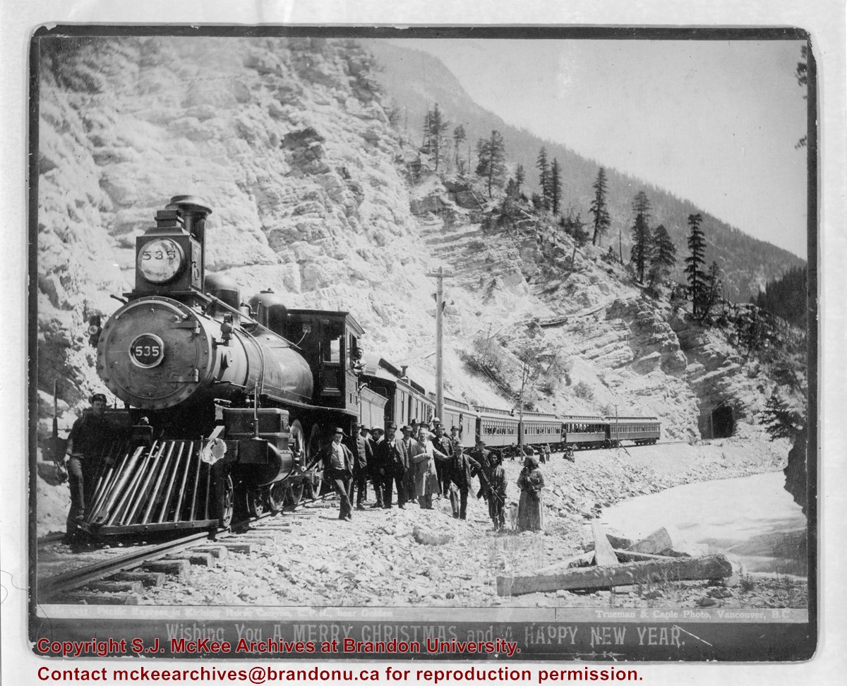
Photograph shows a possible CPR train stopped on the tracks at the base of a mountain. Train employees and passengers are posing alongside the train.
Notes
Writing on the front of the photograph reads: Train #1033 "Pacific Express" in Kicking Horse Pass near Golden / Trueman & Caple Photo, Vancouver, BC / Wishing You A Merry Christmas and a Happy New Year
Date obtained from Margery Hadley McDougall, "R.H. Trueman, Artist and Documentarian," BC Studies, No. 52, Winter 1981-82, pp.129-141.
Photographs have been glued to a backing board that has warped over time
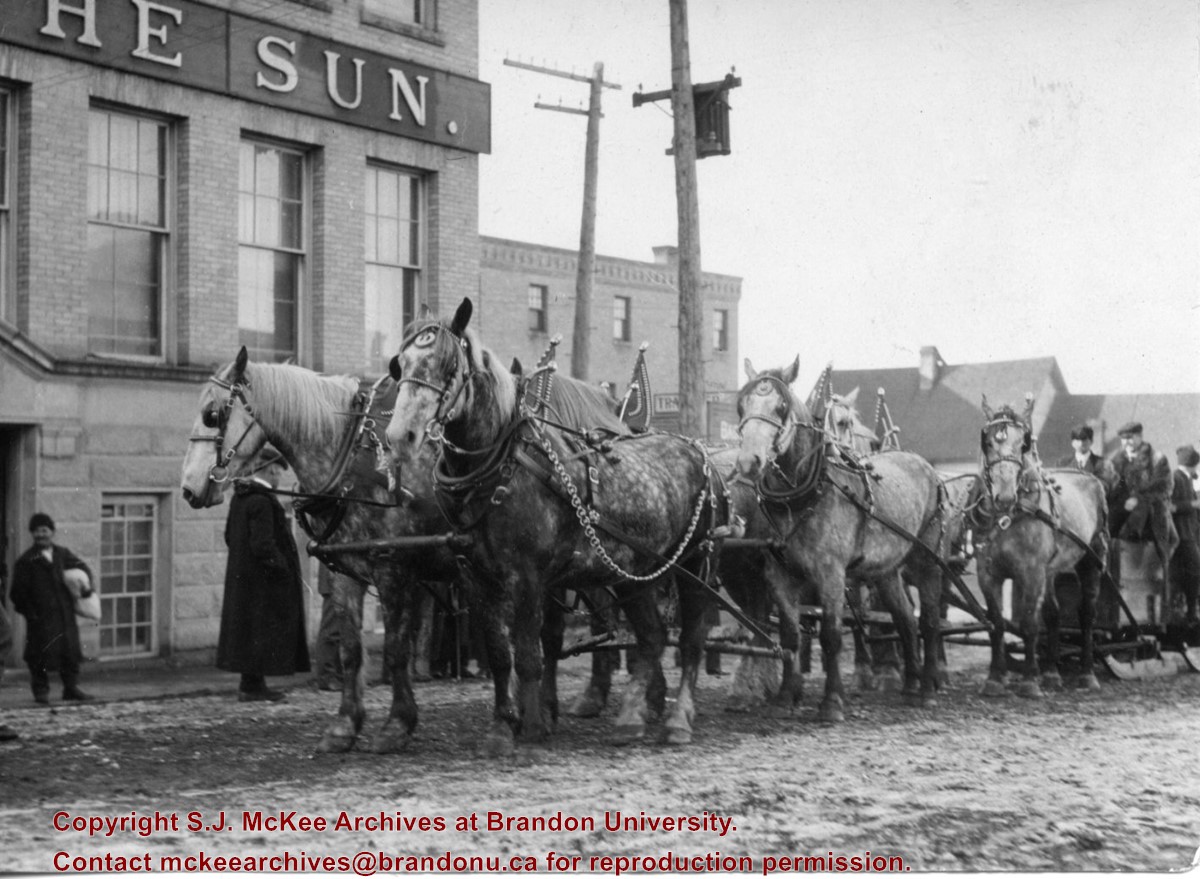
Scope and Content
Photograph shows parade floats travelling on 100 block of 8th Street (Brandon). Horse-drawn floats appear to belong to the Amalgamated Society of Carpenters and Joiners, Murdock/Murdoch Brothers (furniture dealers), and F.W. Durst (cement contractor). Businesses visible in the background include the Sylvester Brothers Manufacturing Company and McDiarmid and Clarke lumber and fuel yard. Spectators in the foreground are leaning on a wooden fence likely belonging to the Old City Hall.
Notes
Writing on the front of the photograph matting reads: 315 July 1906. Two photographs (20-2009.7, 20-2009.6) are glued on the reverse side. Page appears to be from a photo album.
Postcard shows an aerial view of the city of Brandon
Notes
Writing on the back of the postcard reads: No. 10. Brandon, Manitoba, Canada / Aerial View of Brandon / Distributed by Clements Drug Store / Brandon, Manitoba, Canada / Photos by: R.J. "Bob" Snazel. / Printed by: D.W. Friesen & Sons Ltd. Altona, Manitoba, Canada. The postcard is addressed to Mr. F.A. Rosser and is postmarked Brandon 30 May 1970. A 6-cent Queen Elizabeth red postage stamp portraying various modes of the transportation. The stamp has been cancelled with a postmark that reads "Help Retarded Children."
The Medicine Hat Exhibition and Stampede Parade Day was held on Thursday, July 19, 1962, at 9:30 a.m. The local newspaper reported that approximately 24,000 people were in attendance to see parade marshall Rod Ashburner leading 175 entries consisting of 90 floats, 75 horses, and 10 bands. There were 19 parade categories eligible for $12,000 in prize money and included: junior and senior cowboys and cowgirls; fancy and Shetland ponies; sulky class open; comic, commercial, industrial and organizational floats; decorated cars; special ranch class; 4-H Clubs; and a non-competitive class.
The parade route started at Second St. and Allowance Ave., from Second St. to Ash Ave., north on Ash to First St. SE., from First St. S.E. to Fourth Ave., south to Second St. to South Railway St., south on South Railway St. to Third St., with a finish at McLeod Trail. A route map was published in the Medicine Hat News the day before the parade.
Aerial photographs of the parade were taken by Medicine Hat News photographer Howard Heid (1930-2005) from the private helicopter of John Bourn. Bourn was a pilot from Woodville, Wisconsin, who chartered his four-seater helicopter for sight-seers at exhibitions and stampedes across the county.
(Sources: Pat Currie, "Let 'Er Go!," Medicine Hat News, 19 July 1962,1; Harald Gunderson, "'Eye in the Sky' Best Parade View," Medicine Hat News, 19 July 1962,1; "Parade Starts at 9:30 Sharp," 18 July 1962)
Scope and Content
Photograph shows an aerial view of the Medicine Hat Exhibition and Stampede Parade route, with a focus on Second Street SE. Visible store signs include: China Wonderland, Grey Cup Cafe, Lane Bros. & Gibson Ltd., Joy's, Marshall's, Monarch, Gardener's Used Cars, Provincial Treasury Branch, Furvey's Furniture and Appliances, J.J. Moore & Son, Club Cafe, Black Hardware Ltd., Regency Billards, and Sair's Shoe Hospital.
The Medicine Hat Exhibition and Stampede Parade Day was held on Thursday, July 19, 1962, at 9:30 a.m. The local newspaper reported that approximately 24,000 people were in attendance to see parade marshall Rod Ashburner leading 175 entries consisting of 90 floats, 75 horses, and 10 bands. There were 19 parade categories eligible for $12,000 in prize money and included: junior and senior cowboys and cowgirls; fancy and Shetland ponies; sulky class open; comic, commercial, industrial and organizational floats; decorated cars; special ranch class; 4-H Clubs; and a non-competitive class.
The parade route started at Second St. and Allowance Ave., from Second St. to Ash Ave., north on Ash to First St. SE., from First St. S.E. to Fourth Ave., south to Second St. to South Railway St., south on South Railway St. to Third St., with a finish at McLeod Trail. A route map was published in the Medicine Hat News the day before the parade.
Aerial photographs of the parade were taken by Medicine Hat News photographer Howard Heid (1930-2005) from the private helicopter of John Bourn. Bourn was a pilot from Woodville, Wisconsin, who chartered his four-seater helicopter for sight-seers at exhibitions and stampedes across the county.
(Sources: Pat Currie, "Let 'Er Go!," Medicine Hat News, 19 July 1962,1; Harald Gunderson, "'Eye in the Sky' Best Parade View," Medicine Hat News, 19 July 1962,1; "Parade Starts at 9:30 Sharp," 18 July 1962)
Scope and Content
Photograph shows an aerial view of the Medicine Hat Exhibition and Stampede Parade route, with a focus on the First Street SE and North Railway Street merge.
Notes
This photograph appeared on the front page of The Medicine Hat News (19 July 1962).
Photograph shows the construction of the McGuinness home in a new housing development in Medicine Hat, 492 6th Street Northeast. Aerial view shows that neighbouring blocks have yet to be constructed.
Photograph shows the McGuinness home in a new housing development in Medicine Hat, 492 6th Street Northeast. Aerial view shows that neighbouring blocks have yet to be constructed and the backyard to the McGuinness home is completed.
The Medicine Hat Exhibition and Stampede Parade Day was held on Thursday, July 19, 1962, at 9:30 a.m. The local newspaper reported that approximately 24,000 people were in attendance to see parade marshall Rod Ashburner leading 175 entries consisting of 90 floats, 75 horses, and 10 bands. There were 19 parade categories eligible for $12,000 in prize money and included: junior and senior cowboys and cowgirls; fancy and Shetland ponies; sulky class open; comic, commercial, industrial and organizational floats; decorated cars; special ranch class; 4-H Clubs; and a non-competitive class.
The parade route started at Second St. and Allowance Ave., from Second St. to Ash Ave., north on Ash to First St. SE., from First St. S.E. to Fourth Ave., south to Second St. to South Railway St., south on South Railway St. to Third St., with a finish at McLeod Trail. A route map was published in the Medicine Hat News the day before the parade.
Aerial photographs of the parade were taken by Medicine Hat News photographer Howard Heid (1930-2005) from the private helicopter of John Bourn. Bourn was a pilot from Woodville, Wisconsin, who chartered his four-seater helicopter for sight-seers at exhibitions and stampedes across the county.
(Sources: Pat Currie, "Let 'Er Go!," Medicine Hat News, 19 July 1962,1; Harald Gunderson, "'Eye in the Sky' Best Parade View," Medicine Hat News, 19 July 1962,1; "Parade Starts at 9:30 Sharp," 18 July 1962)
Scope and Content
Photograph shows an aerial view of the Medicine Hat Exhibition and Stampede Parade route, with a focus on Second Street SE. A residential area showing homes with extensive backyard gardens can be seen. The South Saskatchewan River can be see on the right of the photograph.
Notes
This photograph shows the neighbourhood before rezoning and commercial development.
The Medicine Hat Exhibition and Stampede Parade Day was held on Thursday, July 19, 1962, at 9:30 a.m. The local newspaper reported that approximately 24,000 people were in attendance to see parade marshall Rod Ashburner leading 175 entries consisting of 90 floats, 75 horses, and 10 bands. There were 19 parade categories eligible for $12,000 in prize money and included: junior and senior cowboys and cowgirls; fancy and Shetland ponies; sulky class open; comic, commercial, industrial and organizational floats; decorated cars; special ranch class; 4-H Clubs; and a non-competitive class.
The parade route started at Second St. and Allowance Ave., from Second St. to Ash Ave., north on Ash to First St. SE., from First St. S.E. to Fourth Ave., south to Second St. to South Railway St., south on South Railway St. to Third St., with a finish at McLeod Trail. A route map was published in the Medicine Hat News the day before the parade.
Aerial photographs of the parade were taken by Medicine Hat News photographer Howard Heid (1930-2005) from the private helicopter of John Bourn. Bourn was a pilot from Woodville, Wisconsin, who chartered his four-seater helicopter for sight-seers at exhibitions and stampedes across the county.
(Sources: Pat Currie, "Let 'Er Go!," Medicine Hat News, 19 July 1962,1; Harald Gunderson, "'Eye in the Sky' Best Parade View," Medicine Hat News, 19 July 1962,1; "Parade Starts at 9:30 Sharp," 18 July 1962)
Scope and Content
Photograph shows an aerial view of the Medicine Hat Exhibition and Stampede Parade route with a focus on the First Street SE and Ash Street. A residential area showing homes with extensive backyard gardens can be seen.
Notes
This photograph shows the neighbourhood before rezoning and commercial development.
The Medicine Hat Exhibition and Stampede Parade Day was held on Thursday, July 19, 1962, at 9:30 a.m. The local newspaper reported that approximately 24,000 people were in attendance to see parade marshall Rod Ashburner leading 175 entries consisting of 90 floats, 75 horses, and 10 bands. There were 19 parade categories eligible for $12,000 in prize money and included: junior and senior cowboys and cowgirls; fancy and Shetland ponies; sulky class open; comic, commercial, industrial and organizational floats; decorated cars; special ranch class; 4-H Clubs; and a non-competitive class.
The parade route started at Second St. and Allowance Ave., from Second St. to Ash Ave., north on Ash to First St. SE., from First St. S.E. to Fourth Ave., south to Second St. to South Railway St., south on South Railway St. to Third St., with a finish at McLeod Trail. A route map was published in the Medicine Hat News the day before the parade.
Aerial photographs of the parade were taken by Medicine Hat News photographer Howard Heid (1930-2005) from the private helicopter of John Bourn. Bourn was a pilot from Woodville, Wisconsin, who chartered his four-seater helicopter for sight-seers at exhibitions and stampedes across the county.
(Sources: Pat Currie, "Let 'Er Go!," Medicine Hat News, 19 July 1962,1; Harald Gunderson, "'Eye in the Sky' Best Parade View," Medicine Hat News, 19 July 1962,1; "Parade Starts at 9:30 Sharp," 18 July 1962)
Scope and Content
Photograph shows an aerial view of the Medicine Hat Exhibition and Stampede Parade route with a focus on the First Street SE and Sixth Avenue intersection. A number of gas stations and garages are visible along this route and include Texaco, Shell, Ford, and B/A. A number of observers can be seen sitting on rooftops.
Notes
This photograph shows the neighbourhood before rezoning and commercial development.


