Skip header and navigation

Revise Search

20 records – page 12 of 1.

Aerial View of Core Area

http://archives.brandonu.ca/en/permalink/descriptions9267
Part Of
RG 11 Lawrence Stuckey fonds
Description Level
Item
GMD
graphic
Date Range
1977
Accession Number
1-2002
Part Of
RG 11 Lawrence Stuckey fonds
Creator
D.L. Bottley
Description Level
Item
Series Number
3.1
Item Number
1-2002.3.1CA19(1)
Accession Number
1-2002
GMD
graphic
Date Range
1977
Physical Description
3 1/2" x 5"
Material Details
Negative
Custodial History
For custodial history see the collection level description of the Lawrence Stuckey collection.
Scope and Content
Aerial view of Brandon's core area
Notes
[Mr. Stuckey put 2 negatives in the same envelope. We have separated them and numbered them CA19(1) and CA19(2).]
Name Access
Aerial View of Core Area
Subject Access
downtowns
aerial photography
Brandon Street Scenes After 1940
Repro Restriction
The McKee Archives is the copyright holder for the Stuckey materials.
Storage Location
Lawrence Stuckey collection
Images
Show Less

Aerial View of Core Area

http://archives.brandonu.ca/en/permalink/descriptions9268
Part Of
RG 11 Lawrence Stuckey fonds
Description Level
Item
GMD
graphic
Date Range
1977
Accession Number
1-2002
Part Of
RG 11 Lawrence Stuckey fonds
Creator
D.L. Bottley
Description Level
Item
Series Number
3.1
Item Number
1-2002.3.1CA19(2)
Accession Number
1-2002
GMD
graphic
Date Range
1977
Physical Description
3 1/2" x 5"
Material Details
Negative
Custodial History
For custodial history see the collection level description of the Lawrence Stuckey collection.
Scope and Content
Aerial view of Brandon's core area
Notes
[Mr. Stuckey put 2 negatives in the same envelope. We have separated them and numbered them CA19(1) and CA19(2).]
Name Access
Aerial View of Core Area
Subject Access
downtowns
aerial photography
Brandon Street Scenes After 1940
Repro Restriction
The McKee Archives is the copyright holder for the Stuckey materials.
Storage Location
Lawrence Stuckey collection
Images
Show Less

800 Block of Rosser Avenue

http://archives.brandonu.ca/en/permalink/descriptions9271
Part Of
RG 11 Lawrence Stuckey fonds
Description Level
Item
GMD
graphic
Date Range
January 21, 1979
Accession Number
1-2002
Part Of
RG 11 Lawrence Stuckey fonds
Creator
L.A. Stuckey
Description Level
Item
Series Number
3.1
Item Number
1-2002.3.1CA21
Accession Number
1-2002
GMD
graphic
Date Range
January 21, 1979
Physical Description
2 1/2" x 2 1/2"
Material Details
Negative
History / Biographical
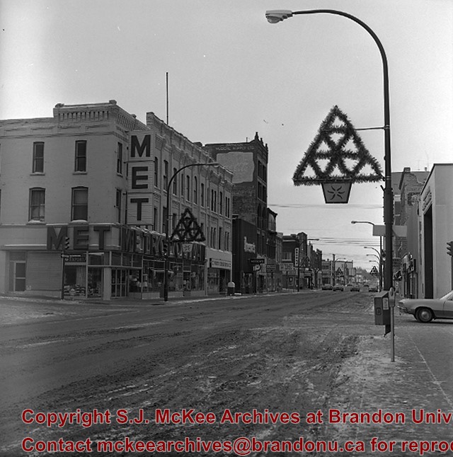
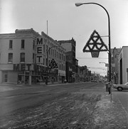
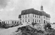
Metropolitan Store building is composed of: Dr. John McDiarmid building (closest) built 1885 and Nation & Shewan building built 1889. Combined building strengthened by E.C. Higgins 1920 - see neg. file K9.
Custodial History
For custodial history see the collection level description of the Lawrence Stuckey collection.
Scope and Content
800 block of Rosser Avenue, south side, looking west from 8th Street.
Name Access
800 Block of Rosser Avenue
Metropolitan Store
McDiarmid Building
Nation & Shewan Building
Subject Access
downtowns
businesses
merchants
Brandon Street Scenes After 1940
Repro Restriction
The McKee Archives is the copyright holder for the Stuckey materials.
Storage Location
Lawrence Stuckey collection
Images
Show Less

900 Block of Rosser Avenue

http://archives.brandonu.ca/en/permalink/descriptions9272
Part Of
RG 11 Lawrence Stuckey fonds
Description Level
Item
GMD
graphic
Date Range
January 21, 1979
Accession Number
1-2002
Part Of
RG 11 Lawrence Stuckey fonds
Creator
L.A. Stuckey
Description Level
Item
Series Number
3.1
Item Number
1-2002.3.1CA22
Accession Number
1-2002
GMD
graphic
Date Range
January 21, 1979
Physical Description
2 1/2" x 2 1/2"
Material Details
Negative
Custodial History
For custodial history see the collection level description of the Lawrence Stuckey collection.
Scope and Content
900 block of Rosser Avenue, looking west
Name Access
900 Block of Rosser Avenue
Brown's Pharmacy
Narvey's
Subject Access
downtowns
businesses
merchants
Brandon Street Scenes After 1940
Repro Restriction
The McKee Archives is the copyright holder for the Stuckey materials.
Storage Location
Lawrence Stuckey collection
Images
Show Less

600 block of Tenth Street

http://archives.brandonu.ca/en/permalink/descriptions9282
Part Of
RG 11 Lawrence Stuckey fonds
Description Level
Item
GMD
graphic
Date Range
February 13, 1977
Accession Number
1-2002
Part Of
RG 11 Lawrence Stuckey fonds
Creator
L.A. Stuckey
Description Level
Item
Series Number
3.1
Item Number
1-2002.3.1CA27(3)
Accession Number
1-2002
GMD
graphic
Date Range
February 13, 1977
Physical Description
2 1/2" x 2 1/2"
Material Details
Negative
History / Biographical
Lawrence Stuckey was born at 645 10th Street.
Custodial History
For custodial history see the collection level description of the Lawrence Stuckey collection.
Scope and Content
Buildings and businesses on the west side of the 600 block of 10th Street.
Name Access
600 Block of Tenth Street
Subject Access
businesses
merchants
laundries
Brandon Street Scenes After 1940
Repro Restriction
The McKee Archives is the copyright holder for the Stuckey materials.
Storage Location
Lawrence Stuckey collection
Arrangement
[Mr. Stuckey put 4 negatives in the same envelope. We have separated them and numbered them CA27(1) through CA27(4).]
Images
Show Less

Aerial View of Downtown

http://archives.brandonu.ca/en/permalink/descriptions9283
Part Of
RG 11 Lawrence Stuckey fonds
Description Level
Item
GMD
graphic
Date Range
[196-]
Accession Number
1-2002
Part Of
RG 11 Lawrence Stuckey fonds
Description Level
Item
Series Number
3.1
Item Number
1-2002.3.1CA28
Accession Number
1-2002
GMD
graphic
Date Range
[196-]
Physical Description
3 1/2" x 5"
Material Details
Negative
Custodial History
For custodial history see the collection level description of the Lawrence Stuckey collection.
Scope and Content
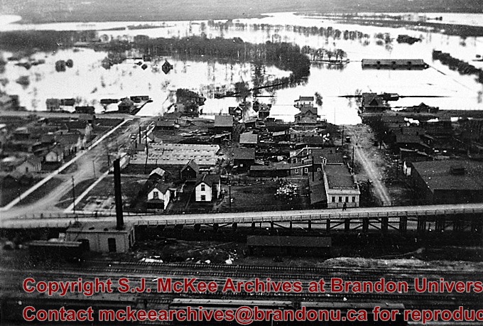
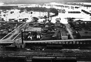
Aerial view of downtown Brandon, including area of new Gallery Mall.
Notes
[This eastward aerial view of downtown Brandon seems to portray an outdoor second-story parking garage proposed by the architectural firm Ward, MacDonald and Partners. The proposed overhead parking is depicted as running continuously from Sixth Street to Tenth Street along Rosser Avenue. The negative appears to have been made by photographing an existing illustration. P.E. 03/06/09]
Name Access
Aerial View of Downtown
Subject Access
downtowns
businesses
merchants
Brandon Street Scenes After 1940
Repro Restriction
The McKee Archives is the copyright holder for the Stuckey materials.
Storage Location
Lawrence Stuckey collection
Images
Show Less

Aerial view - Brandon University campus

http://archives.brandonu.ca/en/permalink/descriptions7989
Part Of
Brandon University Photograph collection
Description Level
Item
GMD
graphic
Date Range
c. 2000
Part Of
Brandon University Photograph collection
Creator
Photograph commissioned by Brandon University and taken by Yourview Aerial Scenics Ltd.
Description Level
Item
Series Number
2.1
Item Number
BUPC 2.1.55
GMD
graphic
Date Range
c. 2000
Physical Description
6" x 4" (colour)
Scope and Content
View is southwest from approximatley 16th Street between Princess and Rosser Avenues. Photograph shows the Brandon University campus, as well as surrounding residential blocks, including Flemming, J.R. Reid and Vincent Massey schools.
Subject Access
aerial photographs
campus photographs
campus buildings
Brandon streets
Images
Show Less

Aerial view - Brandon University campus

http://archives.brandonu.ca/en/permalink/descriptions7990
Part Of
Brandon University Photograph collection
Description Level
Item
GMD
graphic
Date Range
c. 2000
Part Of
Brandon University Photograph collection
Creator
Photograph commissioned by Brandon University and taken by Yourview Aerial Scenics Ltd.
Description Level
Item
Series Number
2.1
Item Number
BUPC 2.1.56
GMD
graphic
Date Range
c. 2000
Physical Description
6" x 4" (colour)
Scope and Content
View is west southwest from approximatley 16th Street between Princess and Lorne Avenues. Photograph shows the Brandon University campus, as well as surrounding residential blocks between 16th and 23rd Streets, Princess and Louise Avenues..
Subject Access
aerial photographs
campus photographs
campus buildings
Brandon streets
Images
Show Less

Aerial view - Brandon University campus

http://archives.brandonu.ca/en/permalink/descriptions7991
Part Of
Brandon University Photograph collection
Description Level
Item
GMD
graphic
Date Range
c. 2000
Part Of
Brandon University Photograph collection
Creator
Photograph commissioned by Brandon University and taken by Yourview Aerial Scenics Ltd.
Description Level
Item
Series Number
2.1
Item Number
BUPC 2.1.57
GMD
graphic
Date Range
c. 2000
Physical Description
6" x 4" (colour)
Scope and Content
View is west from approximatley 17th Street between Lorne and Louise Avenues. Photograph shows a portion of the Brandon University campus (excluding the Education Building and anything north of it), as well as surrounding residential blocks from approximatley 17th Street to 22nd Street.
Subject Access
aerial photographs
campus photographs
campus buildings
Brandon streets
Images
Show Less

Aerial view - Brandon University campus

http://archives.brandonu.ca/en/permalink/descriptions7992
Part Of
Brandon University Photograph collection
Description Level
Item
GMD
graphic
Date Range
c. 1990
Part Of
Brandon University Photograph collection
Description Level
Item
Series Number
2.1
Item Number
BUPC 2.1.58
GMD
graphic
Date Range
c. 1990
Physical Description
5" x 3.5" (colour)
Scope and Content
View is west northwest from approximatley 16th Street and Louise Avenue. Photograph shows the Brandon University campus, prior to the Library Extension, and a large portion of the city to the west of the campus.
Subject Access
aerial photographs
campus photographs
campus buildings
Brandon streets
Images
Show Less

Aerial view - Brandon University campus

http://archives.brandonu.ca/en/permalink/descriptions7993
Part Of
Brandon University Photograph collection
Description Level
Item
GMD
graphic
Date Range
c. 1990
Part Of
Brandon University Photograph collection
Description Level
Item
Series Number
2.1
Item Number
BUPC 2.1.59
GMD
graphic
Date Range
c. 1990
Physical Description
5" x 3.5" (colour)
Scope and Content
View is northwest from approximatley 16th Street and Louise Avenue. Photograph shows the Brandon University campus, prior to the Library Extension, and a large portion of the city to the west of the campus.
Subject Access
aerial photographs
campus photographs
campus buildings
Brandon streets
Show Less

Princess Avenue facing east from 10th Street, Brandon, Manitoba

http://archives.brandonu.ca/en/permalink/descriptions8413
Part Of
Joseph H. Hughes collection
Description Level
Item
GMD
graphic
Date Range
c. 1965
Accession Number
3-1997
Part Of
Joseph H. Hughes collection
Description Level
Item
Series Number
3-1997.1
Item Number
3-1997.1.35
Accession Number
3-1997
GMD
graphic
Date Range
c. 1965
Physical Description
10" x 8" (b/w)
Physical Condition
good
Scope and Content
Photograph shows Princess Avenue facing east from 10th Street. On the north side of Princess Avenue, a B/A Service Station, Princess Cafe, Lindenberg Seeds, and the Central Fire Station are visible. Old City Hall with the war memorial and the Prince Edward Hotel are visible on the south side of Princess Avenue. Traffic is travelling one-way on Princess Avenue.
Name Access
Princess Avenue
City Hall
Prince Edward Hotel
B/A Service Station
Princess Cafe
Lindenberg Seeds
Central Fire Station
Subject Access
downtowns
street scenes
Brandon business buildings & facilities after 1940
building exteriors
hotels
garages
service stations
cafes
memorials
Storage Location
RG 5 photograph storage drawer
Images
Show Less

Original Indian Industrial School

http://archives.brandonu.ca/en/permalink/descriptions9371
Part Of
RG 11 Lawrence Stuckey fonds
Description Level
Item
GMD
graphic
Date Range
[ca. 1904]
Accession Number
1-2002
Part Of
RG 11 Lawrence Stuckey fonds
Creator
Martel
Description Level
Item
Series Number
3.1
Item Number
1-2002.3.1DA20
Accession Number
1-2002
GMD
graphic
Date Range
[ca. 1904]
Physical Description
3 1/2" x 5"
Material Details
Negative
History / Biographical
Built 1893-94, Demolished 1930.
Custodial History
For custodial history see the collection level description of the Lawrence Stuckey collection.
Scope and Content
Original Indian Industrial School
Notes
[It appears that Mr. Stuckey produced this image from a previously published book or postcard. P.E. 11/06/09]
Name Access
Brandon Residential Schools
Subject Access
schools
residential schools
Brandon Schools
Repro Restriction
The McKee Archives is the copyright holder for the Stuckey materials.
Storage Location
Lawrence Stuckey collection
Images
Show Less

Original West Ramp to Eighth St. Bridge

http://archives.brandonu.ca/en/permalink/descriptions9182
Part Of
RG 11 Lawrence Stuckey fonds
Description Level
Item
GMD
graphic
Date Range
May 1922
Accession Number
1-2002
Part Of
RG 11 Lawrence Stuckey fonds
Creator
Wm. Craig
Description Level
Item
Series Number
3.1
Item Number
1-2002.3.1BF5b
Accession Number
1-2002
GMD
graphic
Date Range
May 1922
Physical Description
1 3/4" x 2 1/2"
Material Details
Negative
Custodial History
For custodial history see the collection level description of the Lawrence Stuckey collection.
Scope and Content
overhead view of original West approach to Eighth St. bridge from Assiniboine Ave.
Notes
Assiniboine River in flood; [From combined negative.]
Name Access
Original West Ramp to Eighth St. Bridge
Subject Access
manmade geographic features
bridges
Brandon Eighth Street Bridges
Repro Restriction
The McKee Archives is the copyright holder for the Stuckey materials.
Storage Location
Lawrence Stuckey collection
Images
Show Less

Medicine Hat Exhibition and Stampede - Parade Day 1

http://archives.brandonu.ca/en/permalink/descriptions14142
Part Of
Fred McGuinness collection
Description Level
Item
GMD
graphic
Date Range
1962
Accession Number
1-2015
Part Of
Fred McGuinness collection
Creator
Photographer: Howard Heid, Medicine Hat News
Description Level
Item
Series Number
McG 9
Item Number
1-2015.211
Accession Number
1-2015
GMD
graphic
Date Range
1962
Physical Description
10" x 8" (b/w)
History / Biographical
The Medicine Hat Exhibition and Stampede Parade Day was held on Thursday, July 19, 1962, at 9:30 a.m. The local newspaper reported that approximately 24,000 people were in attendance to see parade marshall Rod Ashburner leading 175 entries consisting of 90 floats, 75 horses, and 10 bands. There were 19 parade categories eligible for $12,000 in prize money and included: junior and senior cowboys and cowgirls; fancy and Shetland ponies; sulky class open; comic, commercial, industrial and organizational floats; decorated cars; special ranch class; 4-H Clubs; and a non-competitive class. The parade route started at Second St. and Allowance Ave., from Second St. to Ash Ave., north on Ash to First St. SE., from First St. S.E. to Fourth Ave., south to Second St. to South Railway St., south on South Railway St. to Third St., with a finish at McLeod Trail. A route map was published in the Medicine Hat News the day before the parade. Aerial photographs of the parade were taken by Medicine Hat News photographer Howard Heid (1930-2005) from the private helicopter of John Bourn. Bourn was a pilot from Woodville, Wisconsin, who chartered his four-seater helicopter for sight-seers at exhibitions and stampedes across the county. (Sources: Pat Currie, "Let 'Er Go!," Medicine Hat News, 19 July 1962,1; Harald Gunderson, "'Eye in the Sky' Best Parade View," Medicine Hat News, 19 July 1962,1; "Parade Starts at 9:30 Sharp," 18 July 1962)
Scope and Content
Photograph shows an aerial view of the Medicine Hat Exhibition and Stampede Parade route, with a focus on Second Street SE. A residential area showing homes with extensive backyard gardens can be seen. The South Saskatchewan River can be see on the right of the photograph.
Notes
This photograph shows the neighbourhood before rezoning and commercial development.
Name Access
Medicine Hat
South Saskatchewan River
Subject Access
parades
floats
aerial photography
aerial views
street scenes
gardens
Repro Restriction
Subject to Canadian Copyright Law
Storage Location
RG 5 photograph storage drawer 2 (hanging photos)
Arrangement
BR #3 Family photos
Images
Show Less

Medicine Hat Exhibition and Stampede - Parade Day 5

http://archives.brandonu.ca/en/permalink/descriptions14146
Part Of
Fred McGuinness collection
Description Level
Item
GMD
graphic
Date Range
1962
Accession Number
1-2015
Part Of
Fred McGuinness collection
Creator
Photographer: Howard Heid, Medicine Hat News
Description Level
Item
Series Number
McG 9
Item Number
1-2015.215
Accession Number
1-2015
GMD
graphic
Date Range
1962
Physical Description
10" x 8" (b/w)
History / Biographical
The Medicine Hat Exhibition and Stampede Parade Day was held on Thursday, July 19, 1962, at 9:30 a.m. The local newspaper reported that approximately 24,000 people were in attendance to see parade marshall Rod Ashburner leading 175 entries consisting of 90 floats, 75 horses, and 10 bands. There were 19 parade categories eligible for $12,000 in prize money and included: junior and senior cowboys and cowgirls; fancy and Shetland ponies; sulky class open; comic, commercial, industrial and organizational floats; decorated cars; special ranch class; 4-H Clubs; and a non-competitive class. The parade route started at Second St. and Allowance Ave., from Second St. to Ash Ave., north on Ash to First St. SE., from First St. S.E. to Fourth Ave., south to Second St. to South Railway St., south on South Railway St. to Third St., with a finish at McLeod Trail. A route map was published in the Medicine Hat News the day before the parade. Aerial photographs of the parade were taken by Medicine Hat News photographer Howard Heid (1930-2005) from the private helicopter of John Bourn. Bourn was a pilot from Woodville, Wisconsin, who chartered his four-seater helicopter for sight-seers at exhibitions and stampedes across the county. (Sources: Pat Currie, "Let 'Er Go!," Medicine Hat News, 19 July 1962,1; Harald Gunderson, "'Eye in the Sky' Best Parade View," Medicine Hat News, 19 July 1962,1; "Parade Starts at 9:30 Sharp," 18 July 1962)
Scope and Content
Photograph shows an aerial view of the Medicine Hat Exhibition and Stampede Parade route with a focus on the First Street SE and Ash Street. A residential area showing homes with extensive backyard gardens can be seen.
Notes
This photograph shows the neighbourhood before rezoning and commercial development.
Name Access
Medicine Hat
South Saskatchewan River
Subject Access
parades
floats
aerial photography
aerial views
street scenes
gardens
Repro Restriction
Subject to Canadian Copyright Law
Storage Location
RG 5 photograph storage drawer 2 (hanging photos)
Arrangement
BR #3 Family photos
Images
Show Less

Medicine Hat Exhibition and Stampede - Parade Day 7

http://archives.brandonu.ca/en/permalink/descriptions14148
Part Of
Fred McGuinness collection
Description Level
Item
GMD
graphic
Date Range
1962
Accession Number
1-2015
Part Of
Fred McGuinness collection
Creator
Photographer: Howard Heid, Medicine Hat News
Description Level
Item
Series Number
McG 9
Item Number
1-2015.217
Accession Number
1-2015
GMD
graphic
Date Range
1962
Physical Description
10" x 8" (b/w)
History / Biographical
The Medicine Hat Exhibition and Stampede Parade Day was held on Thursday, July 19, 1962, at 9:30 a.m. The local newspaper reported that approximately 24,000 people were in attendance to see parade marshall Rod Ashburner leading 175 entries consisting of 90 floats, 75 horses, and 10 bands. There were 19 parade categories eligible for $12,000 in prize money and included: junior and senior cowboys and cowgirls; fancy and Shetland ponies; sulky class open; comic, commercial, industrial and organizational floats; decorated cars; special ranch class; 4-H Clubs; and a non-competitive class. The parade route started at Second St. and Allowance Ave., from Second St. to Ash Ave., north on Ash to First St. SE., from First St. S.E. to Fourth Ave., south to Second St. to South Railway St., south on South Railway St. to Third St., with a finish at McLeod Trail. A route map was published in the Medicine Hat News the day before the parade. Aerial photographs of the parade were taken by Medicine Hat News photographer Howard Heid (1930-2005) from the private helicopter of John Bourn. Bourn was a pilot from Woodville, Wisconsin, who chartered his four-seater helicopter for sight-seers at exhibitions and stampedes across the county. (Sources: Pat Currie, "Let 'Er Go!," Medicine Hat News, 19 July 1962,1; Harald Gunderson, "'Eye in the Sky' Best Parade View," Medicine Hat News, 19 July 1962,1; "Parade Starts at 9:30 Sharp," 18 July 1962)
Scope and Content
Photograph shows an aerial view of the Medicine Hat Exhibition and Stampede Parade route with a focus on the First Street SE and Sixth Avenue intersection. A number of gas stations and garages are visible along this route and include Texaco, Shell, Ford, and B/A. A number of observers can be seen sitting on rooftops.
Notes
This photograph shows the neighbourhood before rezoning and commercial development.
Name Access
Medicine Hat
South Saskatchewan River
Subject Access
parades
floats
aerial photography
aerial views
street scenes
garages
Repro Restriction
Subject to Canadian Copyright Law
Storage Location
RG 5 photograph storage drawer 2 (hanging photos)
Arrangement
BR #3 Family photos
Images
Show Less

Medicine Hat Exhibition and Stampede - Parade Day 8

http://archives.brandonu.ca/en/permalink/descriptions14149
Part Of
Fred McGuinness collection
Description Level
Item
GMD
graphic
Date Range
1962
Accession Number
1-2015
Part Of
Fred McGuinness collection
Creator
Photographer: Howard Heid, Medicine Hat News
Description Level
Item
Series Number
McG 9
Item Number
1-2015.218
Accession Number
1-2015
GMD
graphic
Date Range
1962
Physical Description
10" x 8" (b/w)
History / Biographical
The Medicine Hat Exhibition and Stampede Parade Day was held on Thursday, July 19, 1962, at 9:30 a.m. The local newspaper reported that approximately 24,000 people were in attendance to see parade marshall Rod Ashburner leading 175 entries consisting of 90 floats, 75 horses, and 10 bands. There were 19 parade categories eligible for $12,000 in prize money and included: junior and senior cowboys and cowgirls; fancy and Shetland ponies; sulky class open; comic, commercial, industrial and organizational floats; decorated cars; special ranch class; 4-H Clubs; and a non-competitive class. The parade route started at Second St. and Allowance Ave., from Second St. to Ash Ave., north on Ash to First St. SE., from First St. S.E. to Fourth Ave., south to Second St. to South Railway St., south on South Railway St. to Third St., with a finish at McLeod Trail. A route map was published in the Medicine Hat News the day before the parade. Aerial photographs of the parade were taken by Medicine Hat News photographer Howard Heid (1930-2005) from the private helicopter of John Bourn. Bourn was a pilot from Woodville, Wisconsin, who chartered his four-seater helicopter for sight-seers at exhibitions and stampedes across the county. (Sources: Pat Currie, "Let 'Er Go!," Medicine Hat News, 19 July 1962,1; Harald Gunderson, "'Eye in the Sky' Best Parade View," Medicine Hat News, 19 July 1962,1; "Parade Starts at 9:30 Sharp," 18 July 1962)
Scope and Content
Photograph shows an aerial view of the Medicine Hat Exhibition and Stampede Parade route, with a focus on Second Street SE. Visible store signs include: Gardener's Used Cars, Provincial Treasury Branch, Furvey's Furniture and Appliances, J.J. Moore & Son Furniture, Alberta Credit Jewellers, James Richardson & Sons, Medicine Hat Gas Power Water City Owned Utilities.
Notes
This photograph shows the neighbourhood before rezoning and commercial development.
Name Access
Medicine Hat
South Saskatchewan River
Subject Access
parades
floats
aerial photography
aerial views
street scenes
garages
Repro Restriction
Subject to Canadian Copyright Law
Storage Location
RG 5 photograph storage drawer 2 (hanging photos)
Arrangement
BR #3 Family photos
Images
Show Less

Medicine Hat Exhibition and Stampede - Parade Day 9

http://archives.brandonu.ca/en/permalink/descriptions14150
Part Of
Fred McGuinness collection
Description Level
Item
GMD
graphic
Date Range
1962
Accession Number
1-2015
Part Of
Fred McGuinness collection
Creator
Photographer: Howard Heid, Medicine Hat News
Description Level
Item
Series Number
McG 9
Item Number
1-2015.219
Accession Number
1-2015
GMD
graphic
Date Range
1962
Physical Description
10" x 8" (b/w)
History / Biographical
The Medicine Hat Exhibition and Stampede Parade Day was held on Thursday, July 19, 1962, at 9:30 a.m. The local newspaper reported that approximately 24,000 people were in attendance to see parade marshall Rod Ashburner leading 175 entries consisting of 90 floats, 75 horses, and 10 bands. There were 19 parade categories eligible for $12,000 in prize money and included: junior and senior cowboys and cowgirls; fancy and Shetland ponies; sulky class open; comic, commercial, industrial and organizational floats; decorated cars; special ranch class; 4-H Clubs; and a non-competitive class. The parade route started at Second St. and Allowance Ave., from Second St. to Ash Ave., north on Ash to First St. SE., from First St. S.E. to Fourth Ave., south to Second St. to South Railway St., south on South Railway St. to Third St., with a finish at McLeod Trail. A route map was published in the Medicine Hat News the day before the parade. Aerial photographs of the parade were taken by Medicine Hat News photographer Howard Heid (1930-2005) from the private helicopter of John Bourn. Bourn was a pilot from Woodville, Wisconsin, who chartered his four-seater helicopter for sight-seers at exhibitions and stampedes across the county. (Sources: Pat Currie, "Let 'Er Go!," Medicine Hat News, 19 July 1962,1; Harald Gunderson, "'Eye in the Sky' Best Parade View," Medicine Hat News, 19 July 1962,1; "Parade Starts at 9:30 Sharp," 18 July 1962)
Scope and Content
Photograph shows an aerial view of the Medicine Hat Exhibition and Stampede Parade route with a focus on the First Street SE and Ash Street. A residential area showing homes with extensive backyard gardens can be seen.
Notes
This photograph shows the neighbourhood before rezoning and commercial development.
Name Access
Medicine Hat
South Saskatchewan River
Subject Access
parades
floats
aerial photography
aerial views
street scenes
gardens
Repro Restriction
Subject to Canadian Copyright Law
Storage Location
RG 5 photograph storage drawer 2 (hanging photos)
Arrangement
BR #3 Family photos
Images
Show Less

Medicine Hat Exhibition and Stampede - Parade Day 10

http://archives.brandonu.ca/en/permalink/descriptions14151
Part Of
Fred McGuinness collection
Description Level
Item
GMD
graphic
Date Range
1962
Accession Number
1-2015
Part Of
Fred McGuinness collection
Creator
Photographer: Howard Heid, Medicine Hat News
Description Level
Item
Series Number
McG 9
Item Number
1-2015.220
Accession Number
1-2015
GMD
graphic
Date Range
1962
Physical Description
10" x 8" (b/w)
History / Biographical
The Medicine Hat Exhibition and Stampede Parade Day was held on Thursday, July 19, 1962, at 9:30 a.m. The local newspaper reported that approximately 24,000 people were in attendance to see parade marshall Rod Ashburner leading 175 entries consisting of 90 floats, 75 horses, and 10 bands. There were 19 parade categories eligible for $12,000 in prize money and included: junior and senior cowboys and cowgirls; fancy and Shetland ponies; sulky class open; comic, commercial, industrial and organizational floats; decorated cars; special ranch class; 4-H Clubs; and a non-competitive class. The parade route started at Second St. and Allowance Ave., from Second St. to Ash Ave., north on Ash to First St. SE., from First St. S.E. to Fourth Ave., south to Second St. to South Railway St., south on South Railway St. to Third St., with a finish at McLeod Trail. A route map was published in the Medicine Hat News the day before the parade. Aerial photographs of the parade were taken by Medicine Hat News photographer Howard Heid (1930-2005) from the private helicopter of John Bourn. Bourn was a pilot from Woodville, Wisconsin, who chartered his four-seater helicopter for sight-seers at exhibitions and stampedes across the county. (Sources: Pat Currie, "Let 'Er Go!," Medicine Hat News, 19 July 1962,1; Harald Gunderson, "'Eye in the Sky' Best Parade View," Medicine Hat News, 19 July 1962,1; "Parade Starts at 9:30 Sharp," 18 July 1962)
Scope and Content
Photograph shows an aerial view of the Medicine Hat Exhibition and Stampede Parade route with a focus west of the railway allowance, showing First Street SE, Second Street SE, and Third Street SE.
Notes
This photograph shows the neighbourhood before rezoning and commercial development.
Name Access
Medicine Hat
South Saskatchewan River
Subject Access
parades
floats
aerial photography
aerial views
street scenes
gardens
Repro Restriction
Subject to Canadian Copyright Law
Storage Location
RG 5 photograph storage drawer 2 (hanging photos)
Arrangement
BR #3 Family photos
Images
Show Less

20 records – page 12 of 1.