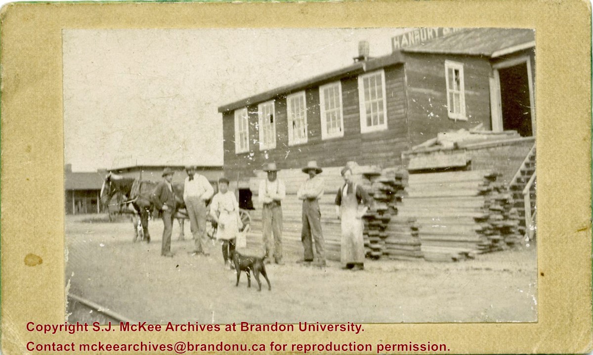
Photograph was given to Fred McGuinness by Linda Bilkoski (nee Lepard) of Lac du Bonnet, MB.
Scope and Content
Photograph shows a group of 17 men stading in a lumber yard.
Notes
This picture is the same as the negative in the Lawrence Stuckey collection. Stuckey obtained a copy of the photo from George Lepard, father of Linda Bilkoski (nee Lepard). Date range based on employment dates of Edward Chalmers. Ed Chalmers was the brother of Catherine Harden (nee Chalmers), mother to Edith Harden, who in turn, is the wife of George Lepard.
Photograph was given to Fred McGuinness by Linda Bilkoski (nee Lepard) of Lac du Bonnet, MB.
Scope and Content
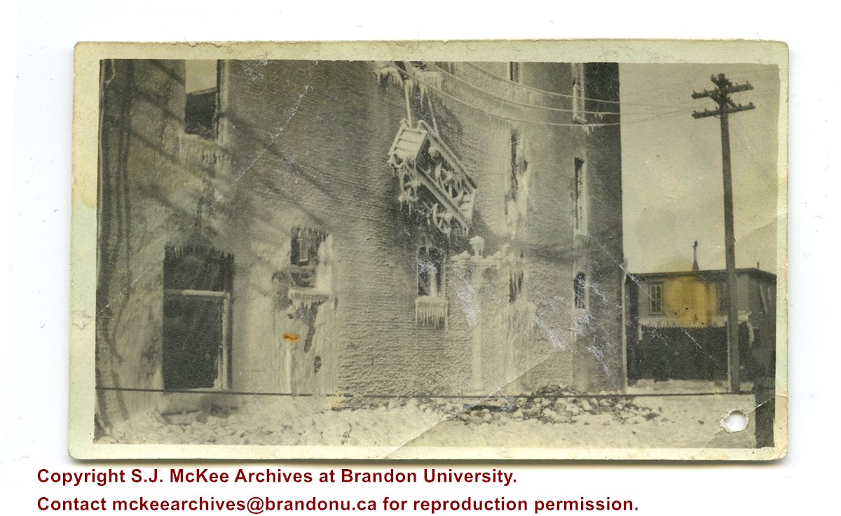
Photograph shows the remains of the Syndicate Block after the fire in January 1916. The building is situated on the southwest corner of Seventh Street and Rosser Avenue. Ice from the firefighting process covers the building. The tailor shop J.S. Laughton & Son (701 Rosser Avenue) can be seen on the north side of Rosser Avenue.
Erected in 1889, on the southeast corner of Rosser Avenue and 7th Street at 806 Rosser Avenue, this block was designed by Brandon architect W.H. Shillinglaw. At the time of its construction the structure housed the Nation & Shewan Department Store, one of Brandon’s largest and most successful drygoods businesses, owned and operated by Fred Nation and Alexander Shewan.
Major improvements were made to the store and an annex was added in 1910. Some of the renovation additions included, but were not limited to, an updated frontage with new copper sash windows and prismatic glass tops, plate glass windows, new fixtures and carpet. With the renovations the floor space of the business was to be almost doubled. The stock of the business also increased, with the Brandon Weekly Sun reporting that when finished, Nation & Shewan would be a “store of which the citizens of Brandon will be justly proud.” The drygoods firm operated until Nation’s death 1926, when it became known as A. Shewan Limited. From 1933 to 1944, the business was known as Shewan and Son. Shortly thereafter, the Metroplitan Stores Ltd began operating out of the Nation & Shewan Block.
In 2000, the Town Centre prepared to knock down the Red Apple Building, formerly the Nation & Shewan Block. The demolition was to make way for the new atrium and entrance for the mall, and begin a new period of redevelopment at the downtown shopping centre.
[History/Bio written by Christy Henry (SJ McKee Archives) and Eileen Trott (Daly House Museum), researched by Morganna Maylon, for 2015 photographic exhibition "Gowen's Brandon: Then and Now".]
Custodial History
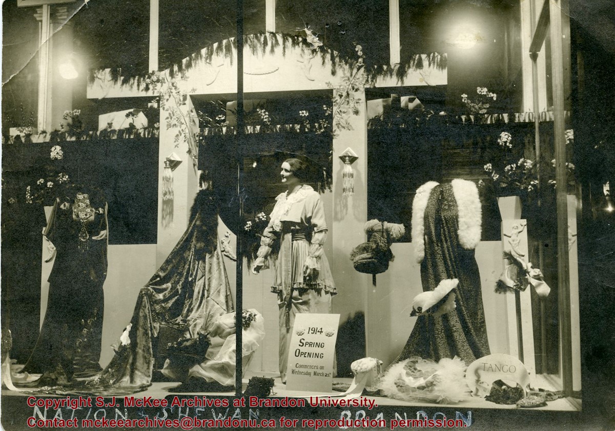
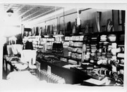
Photograph was given to Fred McGuinness by Linda Bilkoski (nee Lepard) of Lac du Bonnet, MB.
Scope and Content
Photograph shows a display of women's clothing and accessories in the window at Nation & Shewan. A sign reads: 1914 Spring Opening commences on Wednesday March 25th.
Notes
Writing on the back of the photograph reads: Mrs. E. Harden, 33-10th St., City. According to the Henderson's Brandon City Directories, Catharine "Kate" Harden (nee Chalmers) worked as a cashier at Nation & Shewan from 1913 to 1914.
Brandon College looking south from 19th Street. Photograph was taken after Flora Cowan Hall was built but before construction of the Education Building.
Image shows the Brandon College campus from 17th Street looking southwest. The photo was taken after the completion of the original Music Building in 1963, but construction of the Education Building. Also visible are a number of properties on the 200 block of 18th Street and the 200 block of 20th Street.
View is southwest from approximatley 16th Street between Princess and Rosser Avenues. Photograph shows the Brandon University campus, as well as surrounding residential blocks, including Flemming, J.R. Reid and Vincent Massey schools.
View is west southwest from approximatley 16th Street between Princess and Lorne Avenues. Photograph shows the Brandon University campus, as well as surrounding residential blocks between 16th and 23rd Streets, Princess and Louise Avenues..
View is west from approximatley 17th Street between Lorne and Louise Avenues. Photograph shows a portion of the Brandon University campus (excluding the Education Building and anything north of it), as well as surrounding residential blocks from approximatley 17th Street to 22nd Street.
View is west northwest from approximatley 16th Street and Louise Avenue. Photograph shows the Brandon University campus, prior to the Library Extension, and a large portion of the city to the west of the campus.
View is northwest from approximatley 16th Street and Louise Avenue. Photograph shows the Brandon University campus, prior to the Library Extension, and a large portion of the city to the west of the campus.
Photograph shows four men posing in front of a wood-framed shop on 8th Street and Rosser Avenue. The men are wearing three-piece suits or vests and long-sleeved shirts. A painted sign above the shop reads: Wright & Wright, Hamilton Stove & Tin Store. Hanging from the exterior walls are various tin items for sale: lantern, ladel, dust pan, pots and pans.
Notes
Writing on the back of the photograph reads: Corner of 8th & Rosser. Photograph is stamped Public Archives Canada.
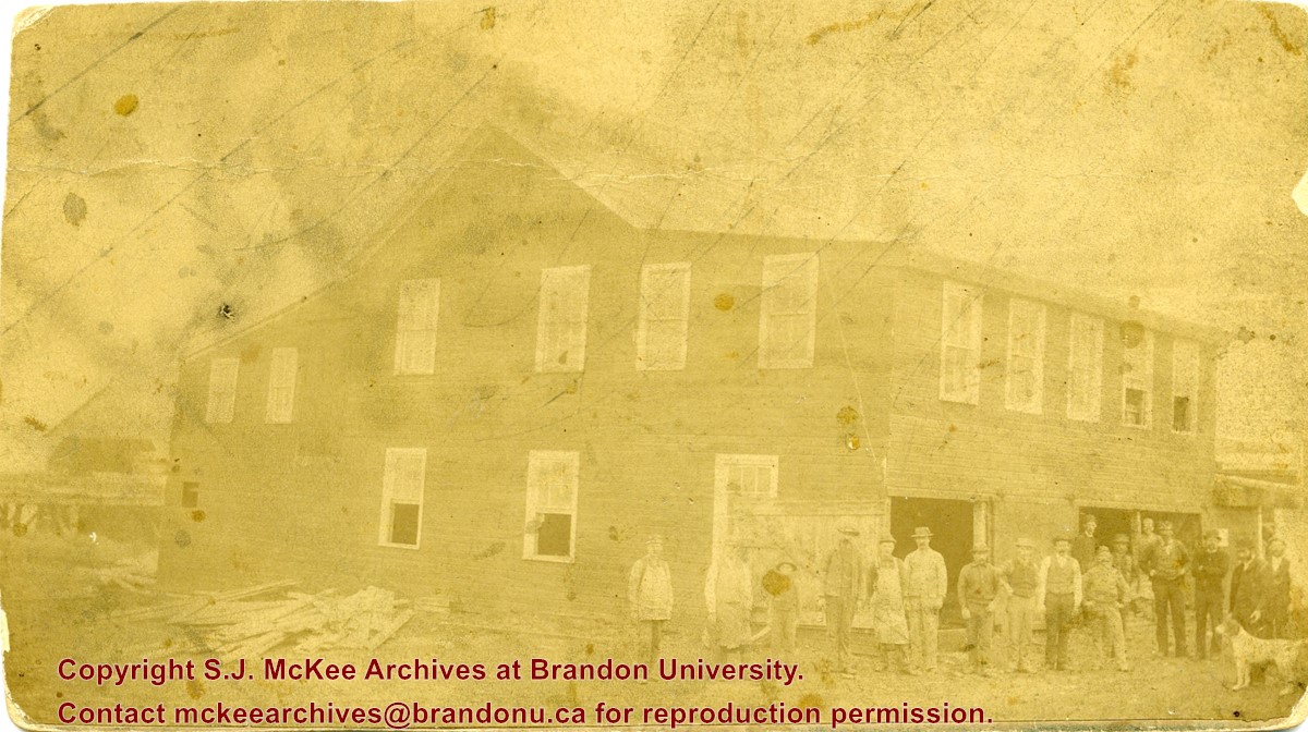
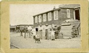
The Hanbury Manufacturing Company was located at 600-698 Assiniboine Avenue.
Scope and Content
Photograph shows a group of men standing in front of a pile of lumber in the yard of Hanbury Manufacturing. A horse is hitched to a buggy in the background and a dog stands in the foreground.
The 1901 Canadian Census places the Lehigh family near Brockville, Ontario, where Everett E. Lehigh (b. 19 May 1881) was farming with his widowed father Solon (b. 20 Aug 1849) and younger sister, Edna (b. 08 Feb 1884). The findagrave.com genealogical website identifies a Mary Wickware as marrying Everett E. Lehigh in Alqonquin, Ontario, on 04 April 1905.
E.E. Lehigh appears in the Henderson's Brandon City Directories in 1919. By 1923, he was Vice-President of Motors Ltd., which had its shop on 151-7th Street. By 1925, Lehigh had taken over the garage, renaming it Lehigh Motors, which became the sole agent for McLaughlin Motor Cars. By 1927, Lehigh Motors had opened a second branch on 12th Street and Princess Avenue, which was formerly the Brandon Auto Garage. Lehigh had become the exclusive dealer for McLaughlin-Buick, Pontiac, and Oldsmobile motor cars.
It appears Lehigh moved his business, E.E. Lehigh Ltd., to 799 Pacific Avenue by 1929. By then, Lehigh had a head office in Winnipeg at 640 Portage Avenue where he served as president and was the provincial distributor for Rugby trucks and Durant cars. Although E.E. Lehigh had a residence in Brandon (325 - 14th Street), Mr. S.G. Cunningham was listed as the Brandon representative for Lehigh Motors Ltd. in the Henderson Directories. By 1931, E.E. Lehigh Ltd. had moved once again, this time to 151-153 - 9th Street.
E.E. Lehigh disappears from the Henderson's Brandon City Directory by 1933 and a Mrs. E.E. Lehigh (possibly Mary (Wickware) Lehigh, d.21 July 1943) is listed under the 14th Street residence. The 9th Street garage address is divided between Munns Taxi (151-9th Street) and Wheat City Auto Wreckers (153-9th Street.)
Custodial History
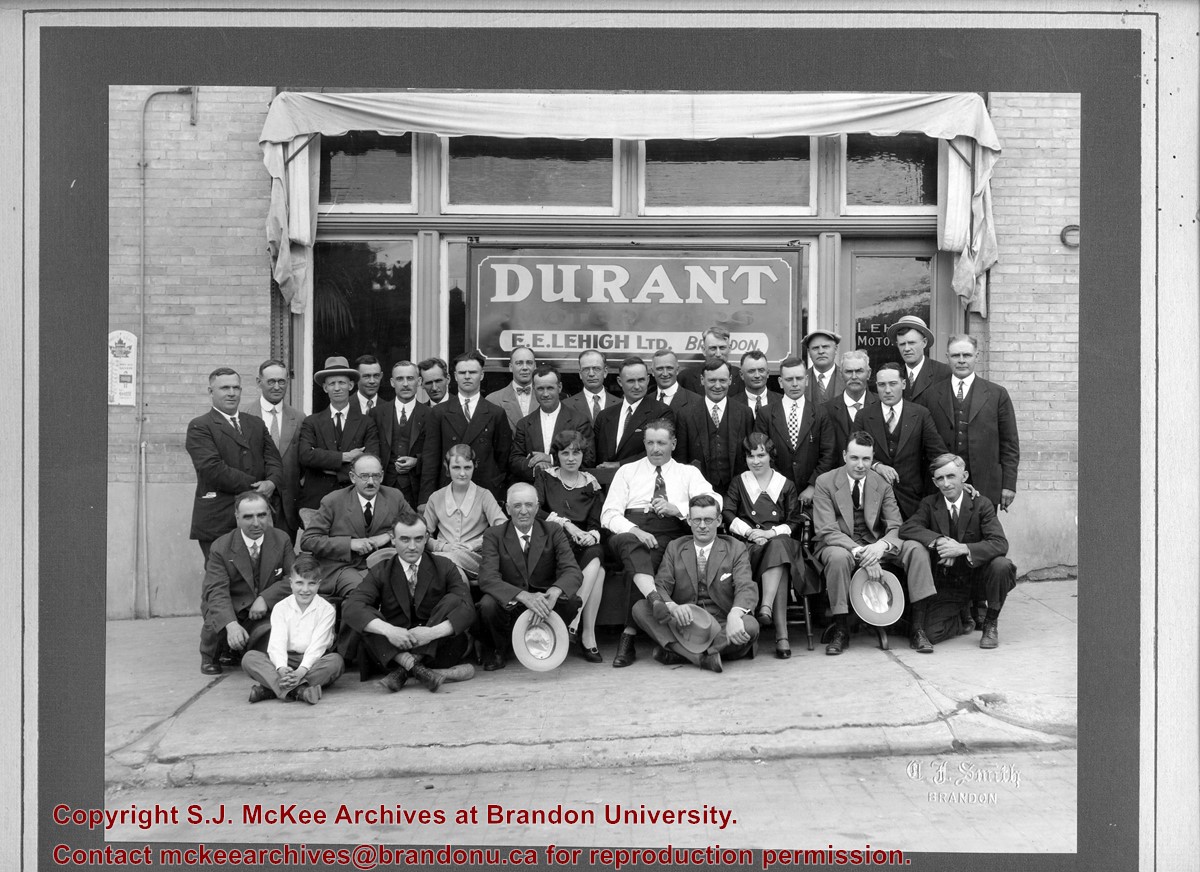
Photograph was in possession of Mrs. Ruby Miles, who passed the image on to Fred McGuinness. McGuinness makes reference to Mrs. Miles and this photograph in his Sunbeams column (Source: F.A. Rosser, "Another interesting chat with a daughter of the plains," Brandon Sun 18 Aug 1981).
Scope and Content
Photograph shows a group portrait of 33 individuals standing and seated in front of the business E.E. Lehigh Ltd., Brandon. The storefront window has a sign that reads: Durant Motor Cars, E.E. Lehigh Ltd., Brandon. The door to the business has Lehigh Motors stencilled on the window. The men are wearing jackets and ties, and there are three women, possibly clerical staff, wearing 1920s era dresses. The elderly man seated in the centre of the photograph, wearing a long-sleeved white dress shirt might be Everett E. Lehigh.
Notes
Writing on the front of the photograph is embossed: C.J. Smith
Image is looking east northeast from approximately the 300 block of 23rd Street between Lorne and Louise Avenues. Photograph shows the Brandon College campus after the opening of the original Music Building in 1963, but before the construction of the Education Building in 1966. A number of house on the 300 blocks of 22nd and 21st Streets are visible in the foreground, with the A.E. McKenzie Seed Co., the Prince Edward Hotel and various grain elevators on the horizon.
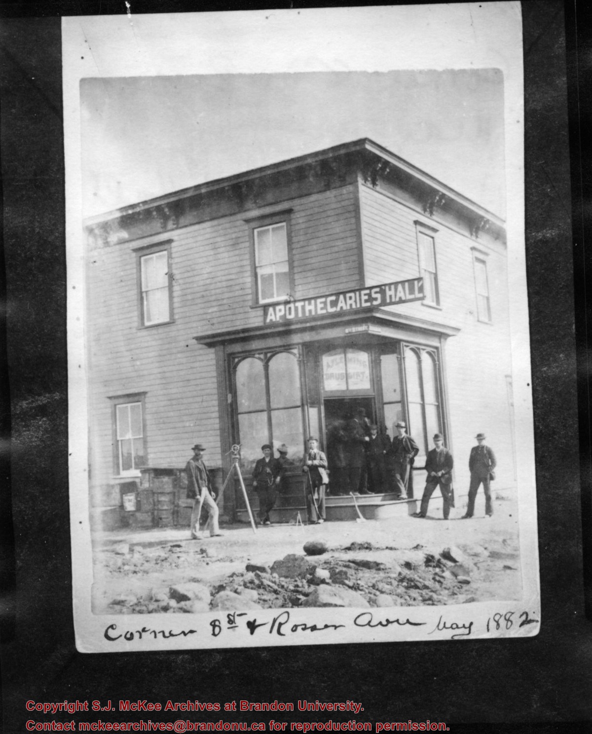
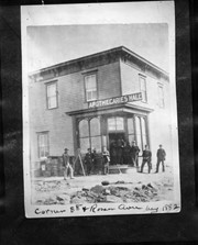
Photograph shows eight men posing in front of a wood-framed building on the corner of 8th Street and Rosser Avenue. Above the building's entrance is a painted sign that reads: Apothecaries' Hall. A. Fleming, Druggist is painted in the window above the door. Street signs designating 8th Street and Rosser Avenue are affixed to the building. A transit/theodolite is mounted on a tripod in front of the store.
Notes
Writing on the front of the photograph reads: Corner 8th St and Rosser Ave May 1882. Writing on the back of the photograph reads: Corner 8th St and Rosser, May 1882, Apthecaries' Hall, A. Fleming, Druggist. Photograph is stamped Public Archives Canada.
The West End Millinery & Dry Goods shop appears in the 1914 Henderson's Brandon City Directory. The store was located in the Avenue Block at 1124 Rosser Avenue. Mrs. A. Barker was listed as the proprietor and milliner. By 1917, Mr. A.F. [Arthur Fred] Barker became the proprietor and Mrs. Barker remained the milliner. By 1919, the shop moved to 130-10th Street, across from the Strand Threatre, where it remained until c.1933.
Custodial History
Donated to Fred McGuinness by G. Baldock in 1971
Scope and Content
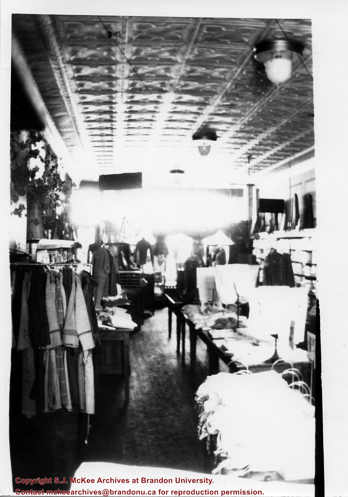
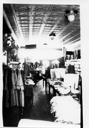
Photograph shows the store interior of West End Millinery & Dry Goods located on 130-10th Street. Coats are hanging from a rack, clothing is displayed on dress forms as well as on wooden tables that are lined up in the centre of the shop. The store's tin ceiling, light fixtures, and hardwood floors are visible.
Notes
Writing on the back of the photograph reads: Part of West End Millinery & Dry Goods 10th St across from Strand Theatre, 1922
The West End Millinery & Dry Goods shop appears in the 1914 Henderson's Brandon City Directory. The store was located in the Avenue Block at 1124 Rosser Avenue. Mrs. A. Barker was listed as the proprietor and milliner. By 1917, Mr. A.F. [Arthur Fred] Barker became the proprietor and Mrs. Barker remained the milliner. By 1919, the shop moved to 130-10th Street, across from the Strand Threatre, where it remained until c.1933.
Custodial History
Donated to Fred McGuinness by G. Baldock in 1971
Scope and Content
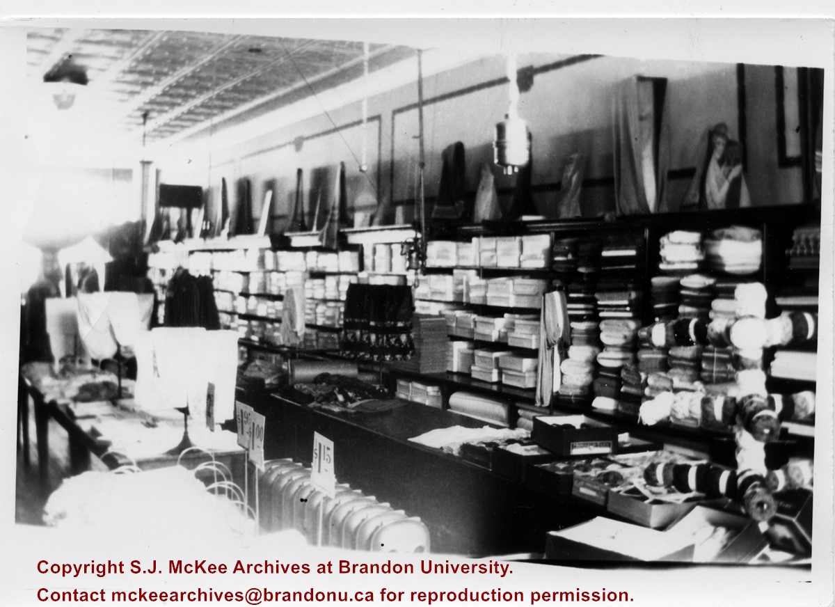
Photograph shows the store interior of West End Millinery & Dry Goods located on 130-10th Street. A shelving unit lines the wall and is filled with boxes, bolts of cloth, and yarns. Displays can be seen on the top of the shelves as well as on wooden tables that are lined up in the centre of the shop. The store's tin ceiling, light fixtures, panelling, radiators, and hardwood floors are visible.
Notes
Writing on the back of the photograph reads: 1/2 of West End Millinery & Dry Goods, 10th St across from Strand Theatre, 1922
Photograph shows seven men posing in front of a wood-framed shack on 10th Street. The men are wearing three-piece suits or vests and long-sleeved shirts. One man can be seen holding an axe another a saw. A double ox-team wagon is in front of the structure.
Notes
Writing on the back of the photograph reads: 10th St. May 1882, Brandon. Photograph is stamped Public Archives Canada.
The Medicine Hat Exhibition and Stampede Parade Day was held on Thursday, July 19, 1962, at 9:30 a.m. The local newspaper reported that approximately 24,000 people were in attendance to see parade marshall Rod Ashburner leading 175 entries consisting of 90 floats, 75 horses, and 10 bands. There were 19 parade categories eligible for $12,000 in prize money and included: junior and senior cowboys and cowgirls; fancy and Shetland ponies; sulky class open; comic, commercial, industrial and organizational floats; decorated cars; special ranch class; 4-H Clubs; and a non-competitive class.
The parade route started at Second St. and Allowance Ave., from Second St. to Ash Ave., north on Ash to First St. SE., from First St. S.E. to Fourth Ave., south to Second St. to South Railway St., south on South Railway St. to Third St., with a finish at McLeod Trail. A route map was published in the Medicine Hat News the day before the parade.
Aerial photographs of the parade were taken by Medicine Hat News photographer Howard Heid (1930-2005) from the private helicopter of John Bourn. Bourn was a pilot from Woodville, Wisconsin, who chartered his four-seater helicopter for sight-seers at exhibitions and stampedes across the county.
(Sources: Pat Currie, "Let 'Er Go!," Medicine Hat News, 19 July 1962,1; Harald Gunderson, "'Eye in the Sky' Best Parade View," Medicine Hat News, 19 July 1962,1; "Parade Starts at 9:30 Sharp," 18 July 1962)
Scope and Content
Photograph shows an aerial view of the Medicine Hat Exhibition and Stampede Parade route, with a focus on Second Street SE. Visible store signs include: China Wonderland, Grey Cup Cafe, Lane Bros. & Gibson Ltd., Joy's, Marshall's, Monarch, Gardener's Used Cars, Provincial Treasury Branch, Furvey's Furniture and Appliances, J.J. Moore & Son, Club Cafe, Black Hardware Ltd., Regency Billards, and Sair's Shoe Hospital.
The Medicine Hat Exhibition and Stampede Parade Day was held on Thursday, July 19, 1962, at 9:30 a.m. The local newspaper reported that approximately 24,000 people were in attendance to see parade marshall Rod Ashburner leading 175 entries consisting of 90 floats, 75 horses, and 10 bands. There were 19 parade categories eligible for $12,000 in prize money and included: junior and senior cowboys and cowgirls; fancy and Shetland ponies; sulky class open; comic, commercial, industrial and organizational floats; decorated cars; special ranch class; 4-H Clubs; and a non-competitive class.
The parade route started at Second St. and Allowance Ave., from Second St. to Ash Ave., north on Ash to First St. SE., from First St. S.E. to Fourth Ave., south to Second St. to South Railway St., south on South Railway St. to Third St., with a finish at McLeod Trail. A route map was published in the Medicine Hat News the day before the parade.
Aerial photographs of the parade were taken by Medicine Hat News photographer Howard Heid (1930-2005) from the private helicopter of John Bourn. Bourn was a pilot from Woodville, Wisconsin, who chartered his four-seater helicopter for sight-seers at exhibitions and stampedes across the county.
(Sources: Pat Currie, "Let 'Er Go!," Medicine Hat News, 19 July 1962,1; Harald Gunderson, "'Eye in the Sky' Best Parade View," Medicine Hat News, 19 July 1962,1; "Parade Starts at 9:30 Sharp," 18 July 1962)
Scope and Content
Photograph shows an aerial view of the Medicine Hat Exhibition and Stampede Parade route, with a focus on the First Street SE and North Railway Street merge.
Notes
This photograph appeared on the front page of The Medicine Hat News (19 July 1962).


