The Brandon Club (L. of center) was built in 1904. This local businessmen's club met in the old firehall until this building was erected by them.
[The Brandon Club closed and its assets were sold at auction on 18 June 2005. P.E. 01/06/2009]
Custodial History
For custodial history see the collection level description of the Lawrence Stuckey collection.
Scope and Content
Overhead view of Princess Avenue, west of 10th Street
Notes
Taken from roof of Prince Edward Hotel. Shows: Rat Portage Lumber Co., St. Matthew's Hall, Brandon Club, In distance Brandon College, International Harvester, Pumping Station. End of brick pavement at 14th Street is notable.
For custodial history see the collection level description of the Lawrence Stuckey collection.
Scope and Content
View of the southeast corner of Tenth Street and Princess Avenue, showing the Prince Edward Hotel (left) and an Imperial Oil Building (right).
Notes
The second floor of the Imperial Oil building became the Imperial Dance Garden in 1934. The small wooden post in a concrete foundation in the centre of the intersection was called a "Silent Policeman". You were supposed to keep it on your left while making a left turn. They took quite a beating.
[Information in "Notes" provided by the Fred McGuinness collection (20-2009).]
Corners of photograph mat are bent. Picture is cracked.
Scope and Content
Photograph shows an early view of Brandon's 6th Street in the 1880s. The Winter & O'Neail Groceries & Provisions and James Smart Hardware storefronts have been photographed. A street sign designating 6th Street can be seen below the Winter & O'Neail sign. A horse and cart is parked in front of the grocery store. A number of men wearing hats and jackets are standing along the boardwalk while posing for the picture. Lumber/timber saws are displayed in teh windows of the hardware store.
Notes
Front of photograph reads: 6th Street, Brandon, Manitoba, 1881-1882, Entrance [to Winter & O'Neail] corner of Rosser Ave & 6th Street.
Postcard shows a street scene of Donald Street looking south from the Portage Avenue Intersection.
Notes
Writing on the back of the postcard reads: Aug 9, Dear ruth, Aunt Eva, Aunt Annie and Fred were over to the bowlnig greens tonight. Every one fine. Doddy. Postcard is addressed to Ruth McGuinness, 337-17th St., Brandon, Man. Postmarked: Winnipeg 12 PM Aug 10 1927 Man.
Photograph shows the Kresge store on the southwest corner of 10th Street and Rosser Avenue. Other 10th Street businesses that are visible on the west side of the street include: James Richardson & Son Investments, Beneficial Finance and Loans, Bass' Storkland, Brandon News & Record Shop, Recreation Bowling and Billiards, and Bottomley's. The Welcome Brandon sign can be seen in the top right corner of the photograph.
Left hand corner of mat is bent. Mock-up instructions are written in pencil at the bottom right hand corner. Portions of the photograph itself are marked with pen.
History / Biographical
The Queen's Hotel was located on the corner of Rosser Avenue and Tenth Street (Steen & Boyce, 1882. Brandon, Manitoba, Canada and Her Industries. Steen & Boyce Publishers Printers & Binders, 81.). Therefore this photo appears to display Rosser Avenue looking east. P.E. 11/06/09
Scope and Content
Photograph shows early Rosser Avenue under construction between 9th Street and 10th Street in the 1880s. Buildings that line the avenue are wood framed and there are wooden boardwalks in front of a few structures. On the north side of Rosser Avenue signs for Fortier & Bucke Commision Agents and Transit House (Hotel) can be seen. On the south side of Rosser Avenue, the Queen's Hotel and Robinson Brothers and Company groceries and dry goods store are open for business. A family appears to be standing on the stoop at the dry goods store. A boy is lounging in the entryway of the Queen's Hotel. A man is standing on a wooden plank that extends across the dirt road of Rosser Avenue between the dry goods store and the commission agents' shop.
Photograph shows the construction of the McGuinness home in a new housing development in Medicine Hat, 492 6th Street Northeast. Aerial view shows that neighbouring blocks have yet to be constructed.
Photograph shows the McGuinness home in a new housing development in Medicine Hat, 492 6th Street Northeast. Aerial view shows that neighbouring blocks have yet to be constructed and the backyard to the McGuinness home is completed.
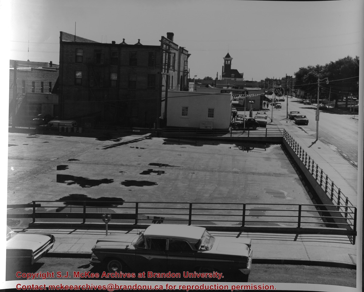
Photograph shows the northeast corner of 10th Street and Princess Avenue facing east. In the background the following Brandon businesses can be seen: back of the Brandon Inn, B/A gas station, The Princess Cafe, and the Central Fire Hall.
Notes
Photograph dated from "Tara's Bulba," the movie playing at the Strand Theatre and similiar vehicles captured in the photograph.
Photograph shows the intersection of 10th Street and Princess Avenue, Brandon, Manitoba. View is facing northwest along west side of the 100-block of 10th Street. A stationary policeman/divider is at the centre of the intersection. Visible businesses include: Doig's, Plaza Shoe Shop, and Cambridge Clothes Shop. A horse-drawn sled is parked in front of Doig's store. The Olympia Block, Cecil Hotel, and CPR Station are visible in the background.
Photograph of west side of 10th Street, Brandon, Manitoba, facing northwest. Visible businesses in the Alexandra Block include Doig's, Box Brothers Hardware and Allied Hardware Stores, followed by Simpsons-Sears and Barry Neill Men's Wear in the Strathcona Block. The Johnny Smith Block is visible in the background.
Photograph of an east side of 10th Street facing north from Princess Avenue. Visible businesses include: Thunderbird Bowl, Canadian Pacific Telegraphs, Pittsburgh Paint & Glass, Strand Theatre, Trans Canada Credit Loans, Ted Heming Jewellers, Carlton Cafe, McKenzie Seeds, Clement Block, Mitrou's Cafe and Tea Room, and Brandon Musical Supply Ltd. Vehicles parked on 10th Street are facing north.
Notes
Photograph dated from "Tara's Bulba," the movie playing at the Strand Theatre and similiar vehicles captured in the photograph.
Photograph shows the northwest corner of 10th Street and Princess Avenue. Traffic on the west side of Princess Avenue appears to travelling both ways. A car waits at the intersection.
Above the west entrance on the corner building is an electric sign that spells "Hughes Bldg." A second storey has yet to be added to the portion of the Doig's shop that is adjacent to the Alexandra Block.
Fitwell Tailors, a barber shop, and the Federal Building are visible on Princess Avenue.
Notes
A negative is contained in the same enclosure with the print.


.jpg?width=1200&404=no-img.jpg&watermark=wmk)
.jpg?width=180&404=no-img.jpg)


.jpg?width=1200&404=no-img.jpg&watermark=wmk)
.jpg?width=180&404=no-img.jpg)


.jpg?width=1200&404=no-img.jpg&watermark=wmk)
.jpg?width=180&404=no-img.jpg)
.jpg?width=1200&404=no-img.jpg&watermark=wmk)
.jpg?width=180&404=no-img.jpg)
.jpg?width=1200&404=no-img.jpg&watermark=wmk)
.jpg?width=180&404=no-img.jpg)


.jpg%3fmaxheight%3d1000%26maxwidth%3d1000%26watermark%3dwmk&description=Princess+Avenue+east+of+Tenth+Street)
.jpg%3fmaxheight%3d1000%26maxwidth%3d1000%26watermark%3dwmk&description=Pacific+Avenue+-+west+of+Tenth+Street)
.jpg%3fmaxheight%3d1000%26maxwidth%3d1000%26watermark%3dwmk&description=Pacific+Avenue+-+west+of+Tenth+Street)
.jpg%3fmaxheight%3d1000%26maxwidth%3d1000%26watermark%3dwmk&description=Pacific+Avenue+-+west+of+Tenth+Street)
.jpg%3fmaxheight%3d1000%26maxwidth%3d1000%26watermark%3dwmk&description=Pacific+Avenue+-+west+of+Tenth+Street)
)