The Medicine Hat Exhibition and Stampede Parade Day was held on Thursday, July 19, 1962, at 9:30 a.m. The local newspaper reported that approximately 24,000 people were in attendance to see parade marshall Rod Ashburner leading 175 entries consisting of 90 floats, 75 horses, and 10 bands. There were 19 parade categories eligible for $12,000 in prize money and included: junior and senior cowboys and cowgirls; fancy and Shetland ponies; sulky class open; comic, commercial, industrial and organizational floats; decorated cars; special ranch class; 4-H Clubs; and a non-competitive class.
The parade route started at Second St. and Allowance Ave., from Second St. to Ash Ave., north on Ash to First St. SE., from First St. S.E. to Fourth Ave., south to Second St. to South Railway St., south on South Railway St. to Third St., with a finish at McLeod Trail. A route map was published in the Medicine Hat News the day before the parade.
Aerial photographs of the parade were taken by Medicine Hat News photographer Howard Heid (1930-2005) from the private helicopter of John Bourn. Bourn was a pilot from Woodville, Wisconsin, who chartered his four-seater helicopter for sight-seers at exhibitions and stampedes across the county.
(Sources: Pat Currie, "Let 'Er Go!," Medicine Hat News, 19 July 1962,1; Harald Gunderson, "'Eye in the Sky' Best Parade View," Medicine Hat News, 19 July 1962,1; "Parade Starts at 9:30 Sharp," 18 July 1962)
Scope and Content
Photograph shows an aerial view of the Medicine Hat Exhibition and Stampede Parade route with a focus on the First Street SE and Ash Street. A residential area showing homes with extensive backyard gardens can be seen.
Notes
This photograph shows the neighbourhood before rezoning and commercial development.
The Medicine Hat Exhibition and Stampede Parade Day was held on Thursday, July 19, 1962, at 9:30 a.m. The local newspaper reported that approximately 24,000 people were in attendance to see parade marshall Rod Ashburner leading 175 entries consisting of 90 floats, 75 horses, and 10 bands. There were 19 parade categories eligible for $12,000 in prize money and included: junior and senior cowboys and cowgirls; fancy and Shetland ponies; sulky class open; comic, commercial, industrial and organizational floats; decorated cars; special ranch class; 4-H Clubs; and a non-competitive class.
The parade route started at Second St. and Allowance Ave., from Second St. to Ash Ave., north on Ash to First St. SE., from First St. S.E. to Fourth Ave., south to Second St. to South Railway St., south on South Railway St. to Third St., with a finish at McLeod Trail. A route map was published in the Medicine Hat News the day before the parade.
Aerial photographs of the parade were taken by Medicine Hat News photographer Howard Heid (1930-2005) from the private helicopter of John Bourn. Bourn was a pilot from Woodville, Wisconsin, who chartered his four-seater helicopter for sight-seers at exhibitions and stampedes across the county.
(Sources: Pat Currie, "Let 'Er Go!," Medicine Hat News, 19 July 1962,1; Harald Gunderson, "'Eye in the Sky' Best Parade View," Medicine Hat News, 19 July 1962,1; "Parade Starts at 9:30 Sharp," 18 July 1962)
Scope and Content
Photograph shows an aerial view of the Medicine Hat Exhibition and Stampede Parade route with a focus west of the railway allowance, showing First Street SE, Second Street SE, and Third Street SE.
Notes
This photograph shows the neighbourhood before rezoning and commercial development.
The Medicine Hat Exhibition and Stampede Parade Day was held on Thursday, July 19, 1962, at 9:30 a.m. The local newspaper reported that approximately 24,000 people were in attendance to see parade marshall Rod Ashburner leading 175 entries consisting of 90 floats, 75 horses, and 10 bands. There were 19 parade categories eligible for $12,000 in prize money and included: junior and senior cowboys and cowgirls; fancy and Shetland ponies; sulky class open; comic, commercial, industrial and organizational floats; decorated cars; special ranch class; 4-H Clubs; and a non-competitive class.
The parade route started at Second St. and Allowance Ave., from Second St. to Ash Ave., north on Ash to First St. SE., from First St. S.E. to Fourth Ave., south to Second St. to South Railway St., south on South Railway St. to Third St., with a finish at McLeod Trail. A route map was published in the Medicine Hat News the day before the parade.
Aerial photographs of the parade were taken by Medicine Hat News photographer Howard Heid (1930-2005) from the private helicopter of John Bourn. Bourn was a pilot from Woodville, Wisconsin, who chartered his four-seater helicopter for sight-seers at exhibitions and stampedes across the county.
(Sources: Pat Currie, "Let 'Er Go!," Medicine Hat News, 19 July 1962,1; Harald Gunderson, "'Eye in the Sky' Best Parade View," Medicine Hat News, 19 July 1962,1; "Parade Starts at 9:30 Sharp," 18 July 1962)
Scope and Content
Photograph shows an aerial view of possibly 8th Street NW and Tweed Avenue NW. A Safeway grocery store, park and residential area are visible. Many of hte homes appear to have gardens.
Notes
This photograph shows the neighbourhood before rezoning and commercial development.
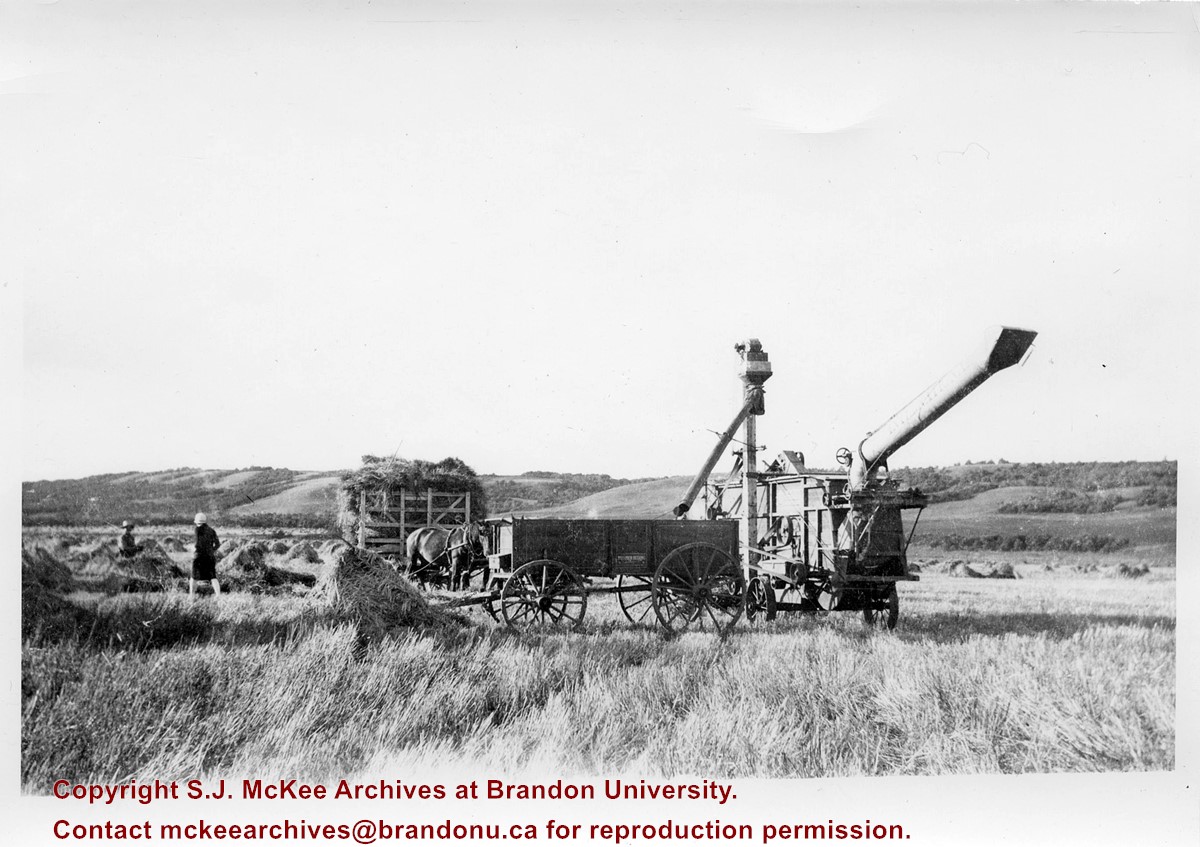
Photograph shows a harvest scene in the Assiniboine Valley. Stacks of wheat are in the process of being loaded into horse-drawn wagon carts. A threashing machine is set-up in the field next to an empty wagon. A woman in 1920s-era clothing is walking in the field.
Notes
Writing on back of photograph reads: 3 prints [20-2009.153 to 20-2009.155]. Threshing at Blight's farm Willow Creek at Chater. Lance Blight of front his father on the rack. 1925.
Mrs. Hilda Rosa Osmond (nee Bridgeman) was born in Hampshire, England in 1888 to parents Edwin Samuel Bridgeman (b.16 Jul 1852; d. 19 June 1922, Brandon) and Rosa Holkham (b. 26 Mar 1859; d. 27 May 1927, Brandon). Edwin was a sailor and Rosa was a dressmaker.
Following the death of her brother Edwin Frederick Bridgeman (1886-1890), the family immigrated to Canada in 1891. The Bridgeman's took the train to Griswold, Manitoba, and settled near Edwin's brother, Albert Bridgeman, and together they farmed the N 1/2 of 36-12-23. The Bridgeman's had three more children, Ellen Grace (b. 27 Jan 1893; d. 22 Feb 1893), Harry Volantine/Valentine (b. 14 Feb 1894), and Charlie Cuthbert (b. 03 Aug 1896; d. 25 Aug 1901). Mr. and Mrs. Edwin Bridgeman retired in 1913 and moved to Brandon where they lived until their respective deaths. The couple are interred in the Brandon Municipal Cemetery.
Hilda married William Arthur Osmond (b. 1867; d. 26 Oct 1943) of Baisingstoke, England, on 31 Jan 1913. They had a daughter Nellie who later married Glen Mossey. The family continued to farm the property on section 36.
Hilda Rosa Osmond passed away in 1980 at the age of 91. She is interred in the Greenwood Cemetery near Harding, Manitoba, where her husband and siblings also rest.
(Sources: England, Births and Christenings, 1538-1975. Salt Lake City, Utah: FamilySearch, 2013 [online]; Findagrave.com; Harding History Committee, Home to Harding 1879-1981 (Brandon: Leech Printing, 1981); Manitoba Vital Statistics Database)
Custodial History
Photograph given to Fred McGuinness by Burton Strange of Kenton, 25 Nov 1974
Scope and Content
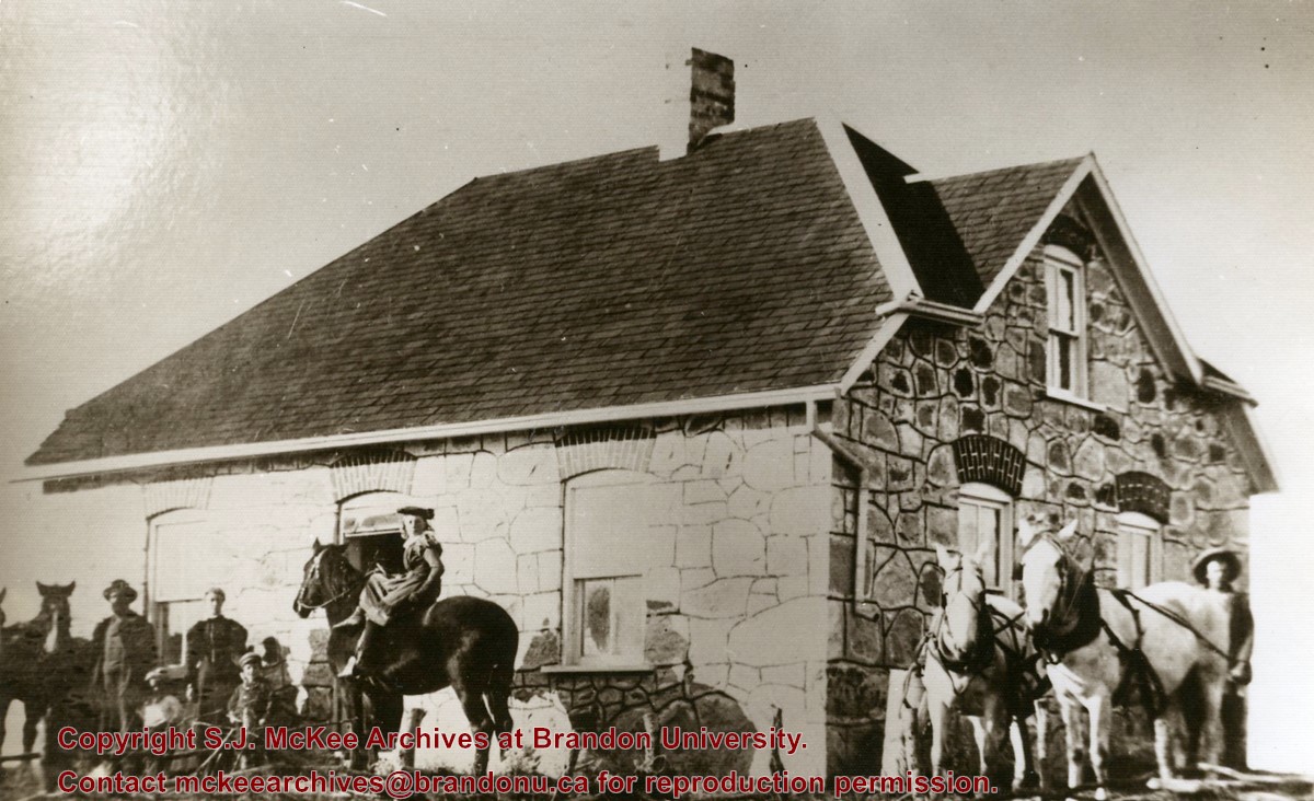
Photograph shows a field stone house builty in 1901 by Edwin and Rosa Bridgeman near Harding, Manitoba. Edwin and Rosa Bridgeman are pictured on the right with Harry and Charlie, shortly before Charlie's death. Hilda sits atop the horse. Albert Bridgeman is pictured on the right with a horse team.
Notes
Photograph was published in the community history by Harding History Committee, Home to Harding 1879-1981 (Brandon: Leech Printing, 1981), 50
The Medicine Hat Exhibition and Stampede Parade Day was held on Thursday, July 19, 1962, at 9:30 a.m. The local newspaper reported that approximately 24,000 people were in attendance to see parade marshall Rod Ashburner leading 175 entries consisting of 90 floats, 75 horses, and 10 bands. There were 19 parade categories eligible for $12,000 in prize money and included: junior and senior cowboys and cowgirls; fancy and Shetland ponies; sulky class open; comic, commercial, industrial and organizational floats; decorated cars; special ranch class; 4-H Clubs; and a non-competitive class.
The parade route started at Second St. and Allowance Ave., from Second St. to Ash Ave., north on Ash to First St. SE., from First St. S.E. to Fourth Ave., south to Second St. to South Railway St., south on South Railway St. to Third St., with a finish at McLeod Trail. A route map was published in the Medicine Hat News the day before the parade.
Aerial photographs of the parade were taken by Medicine Hat News photographer Howard Heid (1930-2005) from the private helicopter of John Bourn. Bourn was a pilot from Woodville, Wisconsin, who chartered his four-seater helicopter for sight-seers at exhibitions and stampedes across the county.
(Sources: Pat Currie, "Let 'Er Go!," Medicine Hat News, 19 July 1962,1; Harald Gunderson, "'Eye in the Sky' Best Parade View," Medicine Hat News, 19 July 1962,1; "Parade Starts at 9:30 Sharp," 18 July 1962)
Scope and Content
Photograph shows an aerial view of the Medicine Hat Exhibition and Stampede Parade route with a focus on the First Street SE. A number of gas stations and garages are visible along this route and include Texaco, Shell, Ford, and B/A. The Fraternal Order of Eagles lodge is also visible.
Notes
This photograph appeared on the front page of The Medicine Hat News (19 July 1962).
Photograph was in possession of Mrs. Ruby Miles, who passed the image on to Fred McGuinness. McGuinness makes reference to Mrs. Miles and this photograph in his Sunbeams column (Brandon Sun 14 September 1978).
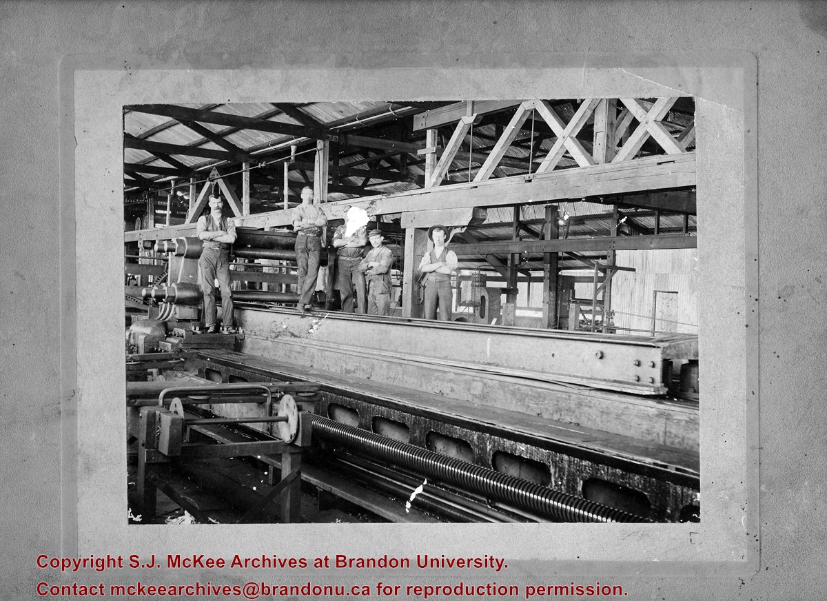
Scope and Content
Photograph shows the interior of the Hanbury Manufacturing Co. Mill. Men identified in the photograph include: Mr. Tom McKenzie (right), Elden Darrow, and Jack Silliker.
Notes
Writing on the back of the photograph reads: Mrs. R. Miles. Provenience and identifications obtained from Lawrence Stuckey collection.
The Medicine Hat Exhibition and Stampede Parade Day was held on Thursday, July 19, 1962, at 9:30 a.m. The local newspaper reported that approximately 24,000 people were in attendance to see parade marshall Rod Ashburner leading 175 entries consisting of 90 floats, 75 horses, and 10 bands. There were 19 parade categories eligible for $12,000 in prize money and included: junior and senior cowboys and cowgirls; fancy and Shetland ponies; sulky class open; comic, commercial, industrial and organizational floats; decorated cars; special ranch class; 4-H Clubs; and a non-competitive class.
The parade route started at Second St. and Allowance Ave., from Second St. to Ash Ave., north on Ash to First St. SE., from First St. S.E. to Fourth Ave., south to Second St. to South Railway St., south on South Railway St. to Third St., with a finish at McLeod Trail. A route map was published in the Medicine Hat News the day before the parade.
Aerial photographs of the parade were taken by Medicine Hat News photographer Howard Heid (1930-2005) from the private helicopter of John Bourn. Bourn was a pilot from Woodville, Wisconsin, who chartered his four-seater helicopter for sight-seers at exhibitions and stampedes across the county.
(Sources: Pat Currie, "Let 'Er Go!," Medicine Hat News, 19 July 1962,1; Harald Gunderson, "'Eye in the Sky' Best Parade View," Medicine Hat News, 19 July 1962,1; "Parade Starts at 9:30 Sharp," 18 July 1962)
Scope and Content
Photograph shows an aerial view of the Medicine Hat Exhibition and Stampede Parade route with a focus on the First Street SE and and the South Railway Street merge. A number of gas stations and garages are visible along this route and include Texaco, Shell, Ford, and B/A. The Fraternal Order of Eagles lodge is also visible.
Notes
This photograph shows the neighbourhood before rezoning and commercial development.
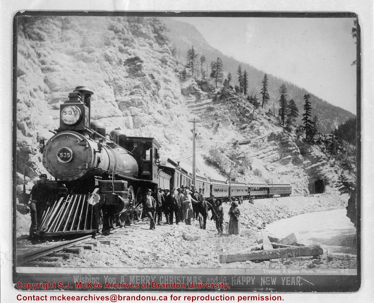
Photograph shows a possible CPR train stopped on the tracks at the base of a mountain. Train employees and passengers are posing alongside the train.
Notes
Writing on the front of the photograph reads: Train #1033 "Pacific Express" in Kicking Horse Pass near Golden / Trueman & Caple Photo, Vancouver, BC / Wishing You A Merry Christmas and a Happy New Year
Date obtained from Margery Hadley McDougall, "R.H. Trueman, Artist and Documentarian," BC Studies, No. 52, Winter 1981-82, pp.129-141.
Photograph was in possession of Mrs. Ruby Miles, who passed the image on to Fred McGuinness. McGuinness makes reference to Mrs. Miles and this photograph in his Sunbeams column (Brandon Sun 14 September 1978).
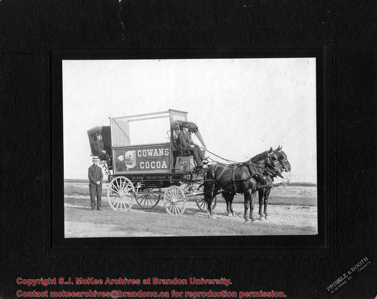
Scope and Content
Photograph shows a horse drawn wagon advertising Cowan's Cocoa. The Gilmore Advertising Company of Toronto appears to be responsible for the ad and the wagon is numbered "No.4". Three men appear in the photograph: one behind the reigns, one in the rear seat of the wagon, and other standing at the rear axel.
Notes
Writing on the front of the photograph matting reads: Pringle & Booth, 181 George Street, Toronto. Writing on the back of the photograph matting reads: Mrs. R. Miles, R.J. Brdgdon?, Right Side 2.50 a day.
Date obtained from http://photographersofontario.ca
Given to Fred McGuinness by George Creighton, 1980?
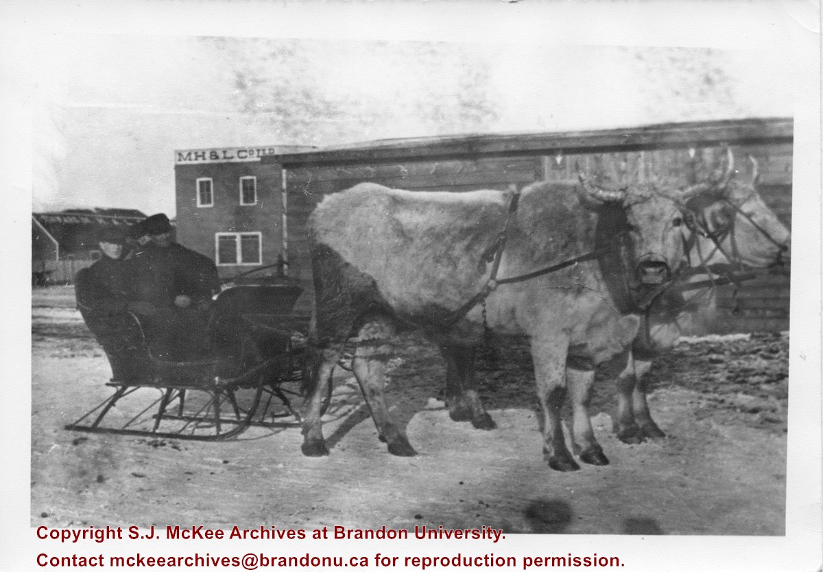
Scope and Content
Photograph shows two men seated in a sleigh pulled by two oxen. Behind the men is a wooden building with a M.H. & L Co. Ltd. sign on its side.
Notes
Writing on the front of the photograph reads: 7.3.80. file family letters. picture of dad's store at Hamiota. M.H.& L. > Manitoba Hardware & Lumber Co. George Creighton gave me this. McG.
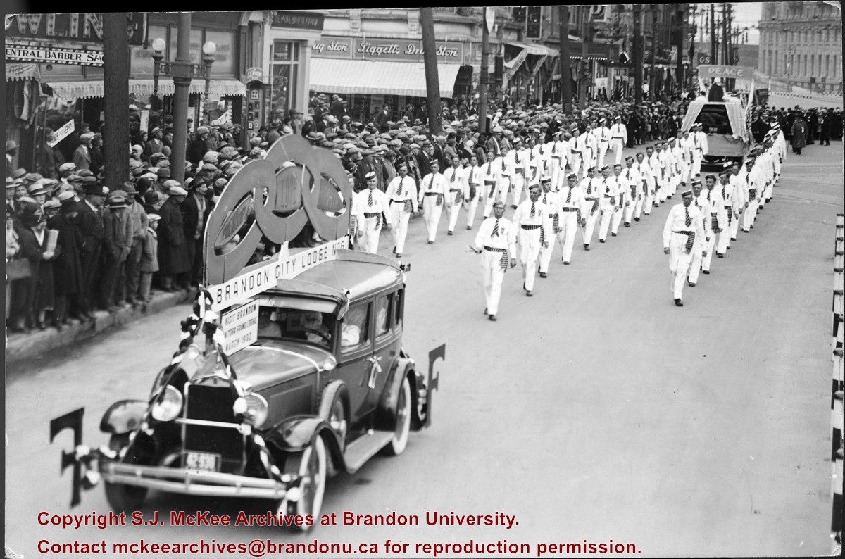
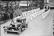
Photograph shows members of the Independent Order of Odd Fellows (IOOF) Brandon City Lodge No.6 parading down a street, possibly Portage Avenue in Winnipeg. Spectators line the street. Visible storefronts include: Central Barber Shop, The Royal Bank of Canada, and Liggetts Drug Store.
Notes
Back of photograph is stamped: The Star Photo Studio, 490 Main Street, Winnipeg, Sep 23, 1931
The International Peace Garden is situated on the international border between Manitoba and North Dakota, adjacent to the Canadian Border Services Boissevain port of entry and the U.S. Customs and Border Protection Agency's Dunseith port of entry. The dedication for the International Peace Garden was held on July 14, 1932. It was estimated that 50,000 people were in attendance on opening day. The park is 9.5-square kilometers or 3.54-square miles.
Custodial History
Pictures were sent to Fred McGuinness in 1970 from E.M. Bergson of Brandon.
Scope and Content
Photograph shows the crowded parking lot at the International Peace Garden's 1932 dedication ceremony. People mill amongst the automobiles and tents can be seen in the background.
Notes
The back of the photograph is stamped: Enameloid Velox Print by the Jul 27 1932, Chicago Postal Photo Supplies, Regina, Sask.
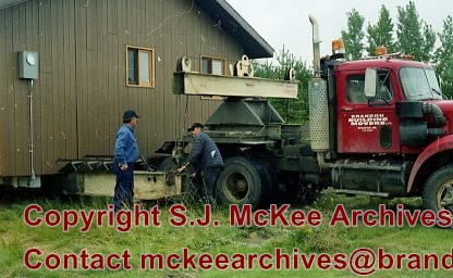
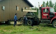
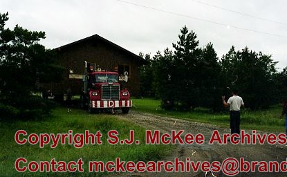
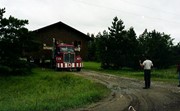
Fred McGuinness is popularly known for his work as the prairie essayist for CBC Radio’s Morningside with Peter Gzowski, a position he held for 17 years. Many of McGuinness’ Morningside essays were autobiographical in nature. He often reported about life on Christmas Tree Farm, a section of land where he and his wife, Christine, built their dream home in the late 1970s. The couple planted a Christmas tree farm on the property and Christine maintained an extensive kitchen garden, while Fred tended honey bees. Life on the farm made its way into radiobroadcasts, Neighborly News columns, and the book "Letters from Section 17: A Collection of Morningside Essays" (Winnipeg: Great Plains Publishing, 1999).
Scope and Content
Set consists of 8 negatives showing a delivery of saplings to the McGuinness property, Christmas Tree Farm, Section 17
Brient was a point along the Algoma Central Railway line that connected the Helen Mine to the Michipicoten Harbour. It is located southwest of Wawa, Ontario.
Scope and Content
Photograph shows ore box cars in a railway yard.
Notes
Writing beneath the photograph in the album reads: yard at Brient


)
)
)
)