Bylaws to keep cattle off streets were being debated by city council about this time.
Custodial History
For custodial history see the collection level description of the Lawrence Stuckey collection.
Scope and Content
J. Birtles Meat Market "Family Butcher", 608 Rosser Avenue
Notes
Mr. Birtles on right, including Mr. Hammell, Hiram Chesley, and Lew Wicket; Photo includes Red Cross Drug Store with proprietor Mr. McCullagh in front; From Brandon Sun files.
[The land on which city hall stood in this photo is now known as Princess Park. P.E. 01/06/09]
Custodial History
For custodial history see the collection level description of the Lawrence Stuckey collection.
Scope and Content
Princess Avenue, showing City Hall & CKX radio tower
Notes
[View is from 9th Street looking east. P.E.]
"Radio towers of CKX on city hall grounds were 150 feet tall; Studio and transmitter were on the east side of city hall." - Fred McGuinness collection (20-2009).
Red ink stain is on the front right corner of postcard
Scope and Content
Photograph shows 10th Street facing south from Princess Avenue. Visible landmarks and businesses include: Manitoba Power Commission (MPC)'s power sub-station, First Baptist Church, Wheat City Arena, and the grand stand at the Exhibition Grounds.
The partial sign visible at the bottom of the photograph on the east side of 10th Street reads Yates and Neale, which refers to a plumbing and heating company that dissolved in 1943 to be replaced by Neale, Stothard and Chapman.
Businesses on the west side of 10th Street include: Dominion Tire & Radio Co., Bolts Barber Shop, Elviss T.E. Co. Stables.
Notes
Information concerning Yates and Neale courtesy Jack Stothard. Writing on the front of the postcard reads: Brandon, Looking S.W., Jerrett Photo. This photograph shows a rare view of the 200-block of 10th Street.
The McKee Archives is the copyright holder for the Stuckey materials.
Storage Location
Lawrence Stuckey collection
Arrangement
[Mr. Stuckey put two negatives in one envelope and taped the prints to the outside of the envelope. We have separated them and numbered the negatives CA16(1) and CA16(2) and the prints CA16(1a) and CA16(2a).]
The Royal Bank moved to this location on 26 October 1929. An existing building was renovated to accomodate the bank. On 28 May 1976 fire destroyed the buildings from the lane west to the Royal Bank.
Scope and Content
Photograph shows the south side of Rosser Avenue between 7th and 8th Streets, west of the Eaton's building. Visible shops include: Vogue [Ladies Wear], Smith's Drugs, Sobie's Tailored Undergarnments, Household Finance Loans, and The Royal Bank of Canada.
Photograph shows the Red Indian (Gasoline) Station on the north side Princess Avenue between 9th and 10th Streets, Brandon. Attached to the west side of the gas station is another shop which contains Hutchings' Drug Store. The Alexandra Block on 10th Street is visible in the background.
For custodial history see the collection level description of the Lawrence Stuckey collection.
Scope and Content
View of Assiniboine Avenue running west, from Ninth Street North
Notes
Second building from right - Westbrook & Fairchild Implements. At left - Western Hotel; Data [courtesy of] Roy Brown from Henderson's [Directory]; From Manitoba Archives


.jpg?width=1200&404=no-img.jpg&watermark=wmk)
.jpg?width=180&404=no-img.jpg)
.jpg?width=1200&404=no-img.jpg&watermark=wmk)
.jpg?width=180&404=no-img.jpg)
.jpg?width=1200&404=no-img.jpg&watermark=wmk)
.jpg?width=180&404=no-img.jpg)
.jpg?width=1200&404=no-img.jpg&watermark=wmk)
.jpg?width=180&404=no-img.jpg)
.jpg?width=1200&404=no-img.jpg&watermark=wmk)
.jpg?width=180&404=no-img.jpg)


.jpg?width=1200&404=no-img.jpg&watermark=wmk)
.jpg?width=180&404=no-img.jpg)
.jpg?width=1200&404=no-img.jpg&watermark=wmk)
.jpg?width=180&404=no-img.jpg)
.jpg?width=1200&404=no-img.jpg&watermark=wmk)
.jpg?width=180&404=no-img.jpg)


.jpg?width=1200&404=no-img.jpg&watermark=wmk)
.jpg?width=180&404=no-img.jpg)
.jpg?width=1200&404=no-img.jpg&watermark=wmk)
.jpg?width=180&404=no-img.jpg)
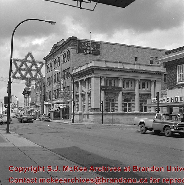
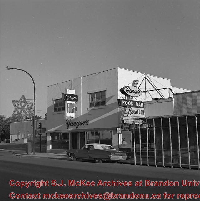
.jpg%3fmaxheight%3d1000%26maxwidth%3d1000%26watermark%3dwmk&description=600+and+700+blocks+of+Rosser+Avenue)
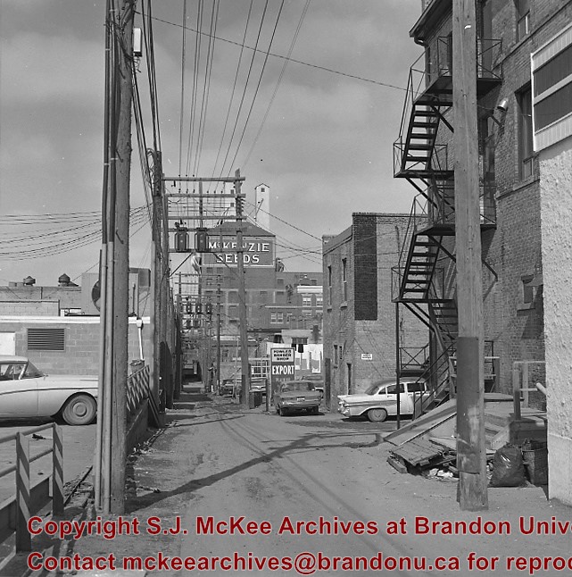
.jpg%3fmaxheight%3d1000%26maxwidth%3d1000%26watermark%3dwmk&description=Back+lane+between+Eighth+Street+and+Ninth+Street)
.jpg%3fmaxheight%3d1000%26maxwidth%3d1000%26watermark%3dwmk&description=Back+lane+between+Eighth+Street+and+Ninth+Street)
.jpg%3fmaxheight%3d1000%26maxwidth%3d1000%26watermark%3dwmk&description=Back+lane+between+Eighth+Street+and+Ninth+Street)
.jpg%3fmaxheight%3d1000%26maxwidth%3d1000%26watermark%3dwmk&description=Back+lane+between+Eighth+Street+and+Ninth+Street)
.jpg%3fmaxheight%3d1000%26maxwidth%3d1000%26watermark%3dwmk&description=200+block+of+Tenth+Street)
.jpg%3fmaxheight%3d1000%26maxwidth%3d1000%26watermark%3dwmk&description=200+block+of+Tenth+Street)
.jpg%3fmaxheight%3d1000%26maxwidth%3d1000%26watermark%3dwmk&description=100+block+of+Tenth+Street)
+north+side+Princess+Avenue+between+9th+Street+and+10th+Street%2c+Brandon%2c+Manitoba)
.jpg%3fmaxheight%3d1000%26maxwidth%3d1000%26watermark%3dwmk&description=Princess+Avenue+east+of+Tenth+Street)
.jpg%3fmaxheight%3d1000%26maxwidth%3d1000%26watermark%3dwmk&description=Northeast+view+from+100+block+of+Tenth+Street)