Skip header and navigation

Revise Search

20 records – page 1 of 1.

Curries Landing (Assiniboine River)

http://archives.brandonu.ca/en/permalink/descriptions11132
Part Of
RG 11 Lawrence Stuckey fonds
Description Level
Item
GMD
graphic
Date Range
Apr. 12, 1977
Part Of
RG 11 Lawrence Stuckey fonds
Creator
L.A. Stuckey
Description Level
Item
Series Number
3.3
Item Number
1-2002.3.3.BSE[366a]
GMD
graphic
Date Range
Apr. 12, 1977
Physical Description
2.5" x 2.5"
Material Details
Negative
Custodial History
For custodial history see the collection level description of the Lawrence Stuckey collection.
Scope and Content
Image of Curries Landing (Assiniboine River).
Notes
[Brandon SE includes communities south of Trans-Canada #1 highway and east of PTH #10.]
Name Access
Curries Landing
Assiniboine River
Subject Access
Rivers
Storage Location
Lawrence Stuckey collection
Arrangement
[Mr. Stuckey put three negatives in the same envelope. We have separated them and numbered the negatives (366a) to(366c)].
Images
Show Less

Curries Landing (Assiniboine River)

http://archives.brandonu.ca/en/permalink/descriptions11134
Part Of
RG 11 Lawrence Stuckey fonds
Description Level
Item
GMD
graphic
Date Range
Apr. 12, 1977
Part Of
RG 11 Lawrence Stuckey fonds
Creator
L.A. Stuckey
Description Level
Item
Series Number
3.3
Item Number
1-2002.3.3.BSE[366b]
GMD
graphic
Date Range
Apr. 12, 1977
Physical Description
2.5" x 2.5"
Material Details
Negative
Custodial History
For custodial history see the collection level description of the Lawrence Stuckey collection.
Scope and Content
Image of Curries Landing (Assiniboine River).
Notes
[Brandon SE includes communities south of Trans-Canada #1 highway and east of PTH #10.]
Name Access
Curries Landing
Assiniboine River
Subject Access
Rivers
Storage Location
Lawrence Stuckey collection
Arrangement
[Mr. Stuckey put three negatives in the same envelope. We have separated them and numbered the negatives (366a) to(366c)].
Images
Show Less

Curries Landing (Assiniboine River)

http://archives.brandonu.ca/en/permalink/descriptions11135
Part Of
RG 11 Lawrence Stuckey fonds
Description Level
Item
GMD
graphic
Date Range
Apr. 12, 1977
Part Of
RG 11 Lawrence Stuckey fonds
Creator
L.A. Stuckey
Description Level
Item
Series Number
3.3
Item Number
1-2002.3.3.BSE[366c]
GMD
graphic
Date Range
Apr. 12, 1977
Physical Description
2.5" x 2.5"
Material Details
Negative
Custodial History
For custodial history see the collection level description of the Lawrence Stuckey collection.
Scope and Content
Image of Curries Landing (Assiniboine River).
Notes
[Brandon SE includes communities south of Trans-Canada #1 highway and east of PTH #10.]
Name Access
Curries Landing
Assiniboine River
Subject Access
Rivers
Storage Location
Lawrence Stuckey collection
Arrangement
[Mr. Stuckey put three negatives in the same envelope. We have separated them and numbered the negatives (366a) to(366c)].
Images
Show Less

Assiniboine River; Treesbank Ferry - Stockton Ferry

http://archives.brandonu.ca/en/permalink/descriptions11023
Part Of
RG 11 Lawrence Stuckey fonds
Description Level
Item
GMD
graphic
Date Range
May 23, 1981
Part Of
RG 11 Lawrence Stuckey fonds
Creator
L.A. Stuckey
Description Level
Item
Series Number
3.3
Item Number
1-2002.3.3.BSE[362a]
GMD
graphic
Date Range
May 23, 1981
Physical Description
2.5" x 2.5"
Material Details
Negative
History / Biographical
Mr. Stuckey's notes: Jacques Wendover and Errol Bredin.
Custodial History
For custodial history see the collection level description of the Lawrence Stuckey collection.
Scope and Content
Image of Assiniboine River; Treesbank Ferry - Stockton Ferry.
Notes
[Brandon SE includes communities south of Trans-Canada #1 highway and east of PTH #10.]
Name Access
Assiniboine River
Stockton, Manitoba
Stockton Ferry
Treesbank Ferry
Jacques Wendover
Errol Bredin
Subject Access
ferries
Transportation
water transportation
ferry services
Rivers
Storage Location
Lawrence Stuckey collection
Arrangement
[Mr. Stuckey put four negatives in the same envelope. We have separated them and numbered the negatives (362a) to (362d)].
Images
Show Less

Assiniboine River; Treesbank Ferry - Stockton Ferry

http://archives.brandonu.ca/en/permalink/descriptions11024
Part Of
RG 11 Lawrence Stuckey fonds
Description Level
Item
GMD
graphic
Date Range
May 23, 1981
Part Of
RG 11 Lawrence Stuckey fonds
Creator
L.A. Stuckey
Description Level
Item
Series Number
3.3
Item Number
1-2002.3.3.BSE[362b]
GMD
graphic
Date Range
May 23, 1981
Physical Description
2.5" x 2.5"
Material Details
Negative
History / Biographical
Mr. Stuckey's notes: Jacques Wendover and Errol Bredin.
Custodial History
For custodial history see the collection level description of the Lawrence Stuckey collection.
Scope and Content
Image of Assiniboine River; Treesbank Ferry - Stockton Ferry.
Notes
[Brandon SE includes communities south of Trans-Canada #1 highway and east of PTH #10.]
Name Access
Assiniboine River
Stockton, Manitoba
Stockton Ferry
Treesbank Ferry
Jacques Wendover
Errol Bredin
Subject Access
ferries
Transportation
water transportation
ferry services
Rivers
Storage Location
Lawrence Stuckey collection
Arrangement
[Mr. Stuckey put four negatives in the same envelope. We have separated them and numbered the negatives (362a) to (362d)].
Images
Show Less

Assiniboine River; Treesbank Ferry - Stockton Ferry

http://archives.brandonu.ca/en/permalink/descriptions11025
Part Of
RG 11 Lawrence Stuckey fonds
Description Level
Item
GMD
graphic
Date Range
May 23, 1981
Part Of
RG 11 Lawrence Stuckey fonds
Creator
L.A. Stuckey
Description Level
Item
Series Number
3.3
Item Number
1-2002.3.3.BSE[362c]
GMD
graphic
Date Range
May 23, 1981
Physical Description
2.5" x 2.5"
Material Details
Negative
History / Biographical
Mr. Stuckey's notes: Jacques Wendover and Errol Bredin.
Custodial History
For custodial history see the collection level description of the Lawrence Stuckey collection.
Scope and Content
Image of Assiniboine River; Treesbank Ferry - Stockton Ferry.
Notes
[Brandon SE includes communities south of Trans-Canada #1 highway and east of PTH #10.]
Name Access
Assiniboine River
Stockton, Manitoba
Stockton Ferry
Treesbank Ferry
Jacques Wendover
Errol Bredin
Subject Access
ferries
Transportation
water transportation
ferry services
Rivers
Storage Location
Lawrence Stuckey collection
Arrangement
[Mr. Stuckey put four negatives in the same envelope. We have separated them and numbered the negatives (362a) to (362d)].
Images
Show Less

Assiniboine River; Treesbank Ferry - Stockton Ferry

http://archives.brandonu.ca/en/permalink/descriptions11026
Part Of
RG 11 Lawrence Stuckey fonds
Description Level
Item
GMD
graphic
Date Range
May 23, 1981
Part Of
RG 11 Lawrence Stuckey fonds
Creator
L.A. Stuckey
Description Level
Item
Series Number
3.3
Item Number
1-2002.3.3.BSE[362d]
GMD
graphic
Date Range
May 23, 1981
Physical Description
2.5" x 2.5"
Material Details
Negative
History / Biographical
Mr. Stuckey's notes: Jacques Wendover and Errol Bredin.
Custodial History
For custodial history see the collection level description of the Lawrence Stuckey collection.
Scope and Content
Image of Assiniboine River; Treesbank Ferry - Stockton Ferry.
Notes
[Brandon SE includes communities south of Trans-Canada #1 highway and east of PTH #10.]
Name Access
Assiniboine River
Stockton, Manitoba
Stockton Ferry
Treesbank Ferry
Jacques Wendover
Errol Bredin
Subject Access
ferries
Transportation
water transportation
ferry services
Rivers
Storage Location
Lawrence Stuckey collection
Arrangement
[Mr. Stuckey put four negatives in the same envelope. We have separated them and numbered the negatives (362a) to (362d)].
Images
Show Less

Skyline from First Street Bridge

http://archives.brandonu.ca/en/permalink/descriptions9269
Part Of
RG 11 Lawrence Stuckey fonds
Description Level
Item
GMD
graphic
Date Range
August 24, 1978
Accession Number
1-2002
Part Of
RG 11 Lawrence Stuckey fonds
Creator
L.A. Stuckey
Description Level
Item
Series Number
3.1
Item Number
1-2002.3.1CA20(1)
Accession Number
1-2002
GMD
graphic
Date Range
August 24, 1978
Physical Description
2 1/2" x 2 1/2"
Material Details
Negative
Custodial History
For custodial history see the collection level description of the Lawrence Stuckey collection.
Scope and Content
Skyline from First Street Bridge, looking southwest.
Name Access
Skyline from First Street Bridge
Assiniboine River
Subject Access
downtowns
railways
trains
Canadian Pacific Railway
Brandon Street Scenes After 1940
Repro Restriction
The McKee Archives is the copyright holder for the Stuckey materials.
Storage Location
Lawrence Stuckey collection
Arrangement
[Mr. Stuckey put one negative in an envelope and taped the print to the outside of the envelope. We have separated them and numbered the negative CA20(1) and the print CA20(1a).]
Images
Show Less

Skyline from First Street Bridge

http://archives.brandonu.ca/en/permalink/descriptions9270
Part Of
RG 11 Lawrence Stuckey fonds
Description Level
Item
GMD
graphic
Date Range
August 24, 1978
Accession Number
1-2002
Part Of
RG 11 Lawrence Stuckey fonds
Creator
L.A. Stuckey
Description Level
Item
Series Number
3.1
Item Number
1-2002.3.1CA20(1a)
Accession Number
1-2002
GMD
graphic
Date Range
August 24, 1978
Physical Description
2 1/2" x 2 1/2"
Material Details
Photograph
Custodial History
For custodial history see the collection level description of the Lawrence Stuckey collection.
Scope and Content
Skyline from First Street Bridge, looking southwest.
Name Access
Skyline from First Street Bridge
Assiniboine River
Subject Access
downtowns
railways
trains
Canadian Pacific Railway
Brandon Street Scenes After 1940
Repro Restriction
The McKee Archives is the copyright holder for the Stuckey materials.
Storage Location
Lawrence Stuckey collection
Arrangement
[Mr. Stuckey put one negative in an envelope and taped the print to the outside of the envelope. We have separated them and numbered the negative CA20(1) and the print CA20(1a).]
Images
Show Less
Part Of
CKX fonds
Description Level
Item
GMD
graphic
Date Range
after 1954
Accession Number
11-2010
Part Of
CKX fonds
Creator
CKX
Description Level
Item
Series Number
S
Item Number
11-2010.S116k
Accession Number
11-2010
GMD
graphic
Date Range
after 1954
Physical Description
5" x 4" (b/w)
Material Details
Negative
Custodial History
See fonds level of the CKX records for custodial history.
Scope and Content
Image of the Assiniboine River.
Name Access
CKX
Assiniboine River
Subject Access
winter
Rivers
bridges
building exteriors
trees
Storage Location
CKX fonds - 2010 accessions
Images
Show Less
Part Of
CKX fonds
Description Level
Item
GMD
graphic
Date Range
after 1954
Accession Number
11-2010
Part Of
CKX fonds
Creator
CKX
Description Level
Item
Series Number
S
Item Number
11-2010.S116j
Accession Number
11-2010
GMD
graphic
Date Range
after 1954
Physical Description
5" x 4" (b/w)
Material Details
Negative
Custodial History
See fonds level of the CKX records for custodial history.
Scope and Content
Image of people swimming in the Assiniboine River.
Name Access
CKX
Assiniboine River
Subject Access
Rivers
building exteriors
persons
swimming
cars
Storage Location
CKX fonds - 2010 accessions
Images
Show Less

Stockton Ferry, Stockton, Manitoba

http://archives.brandonu.ca/en/permalink/descriptions11022
Part Of
RG 11 Lawrence Stuckey fonds
Description Level
Item
GMD
graphic
Date Range
May 23, 1981
Part Of
RG 11 Lawrence Stuckey fonds
Creator
L.A. Stuckey
Description Level
Item
Series Number
3.3
Item Number
1-2002.3.3.BSE[361]
GMD
graphic
Date Range
May 23, 1981
Physical Description
2.5" x 2.5"
Material Details
Negative
Custodial History
For custodial history see the collection level description of the Lawrence Stuckey collection.
Notes
[Brandon SE includes communities south of Trans-Canada #1 highway and east of PTH #10.]
Name Access
Assiniboine River
Stockton, Manitoba
Stockton Ferry
Subject Access
ferries
Transportation
water transportation
ferry services
Rivers
Storage Location
Lawrence Stuckey collection
Images
Show Less

Parade on 8th Street

http://archives.brandonu.ca/en/permalink/descriptions13696
Part Of
Fred McGuinness collection
Description Level
Item
GMD
graphic
Date Range
1906
Accession Number
20-2009
Part Of
Fred McGuinness collection
Description Level
Item
Series Number
McG 9
Item Number
20-2009.6
Accession Number
20-2009
GMD
graphic
Date Range
1906
Physical Description
8" x 6" (b/w)
Material Details
on matting
Physical Condition
Photographs have been glued to a backing board that has warped over time
Scope and Content
Photograph shows parade floats travelling on 100 block of 8th Street (Brandon). Horse-drawn floats appear to belong to the Amalgamated Society of Carpenters and Joiners, Murdock/Murdoch Brothers (furniture dealers), and F.W. Durst (cement contractor). Businesses visible in the background include the Sylvester Brothers Manufacturing Company and McDiarmid and Clarke lumber and fuel yard. Spectators in the foreground are leaning on a wooden fence likely belonging to the Old City Hall.
Notes
Writing on the front of the photograph matting reads: 315 July 1906. Two photographs (20-2009.7, 20-2009.6) are glued on the reverse side. Page appears to be from a photo album.
Name Access
Sylvester Brothers Manufacturing Co.
8th Street
McDiarmid & Clarke
Murdoch Brothers
Murdock Brothers
F.W. Durst
Subject Access
parades
Transportation
parade floats
horses
downtown
Storage Location
RG 5 photograph storage drawer 2 (hanging photos)
Images
Show Less

Rosser Avenue and 8th Street during winter storm

http://archives.brandonu.ca/en/permalink/descriptions13706
Part Of
Fred McGuinness collection
Description Level
Item
GMD
graphic
Date Range
1906
Accession Number
20-2009
Part Of
Fred McGuinness collection
Description Level
Item
Series Number
McG 9
Item Number
20-2009.16
Accession Number
20-2009
GMD
graphic
Date Range
1906
Physical Description
6.5" x 4.25" (b/w)
Material Details
on matting
Physical Condition
Photographs have been glued to a backing board that has warped over time
Custodial History
On 16 November 1906, Manitoba was hit by a severe winter storm that began that Thursday evening and extended through the weekend. The Brandon Daily Sun ("Storm Extends Over a Large Territory," 17 Nov. 1906, 1) reported that rail and telegraph services had been disrupted, country roads were impassable, and business in town was at a stand still. Following the weekend, the daily reported the blizzard was one of the greatest in recent memory. CPR trains had been caught in drifts by Carberry and an express car had caught fire and was destroyed ("Worst Storm in Many Years," Brandon Daily Sun, 19 Nov. 1906, 1).
Scope and Content
Photograph shows street view of north side of Rosser Avenue, primarily the 700 block. The Fleming Block, Beaubier Block and its Empire Hotel, A.M. Percival (a grocer), the Brandon Hardware Company (600 block), and the Arlington Hotel (500 block) are visible along the north side of the avenue. The Bank of Hamilton Building on the southeast corner of 8th Street and Rosser appears to be under construction. The streets are muddy and a horse and buggy is traveling west on Rosser Avenue.
Notes
Writing on the front of the photograph matting reads: during the great storm of November 16 1906, 341. The photograph appears to be taken from the interior of a builing on the southwest corner of 7th Street and Rosser Avenue. Page appears to be from a photo album.
Name Access
Fleming Block
8th Street
Rosser Avenue
Subject Access
Street scene
downtown
storefronts
storms
winter
Storage Location
RG 5 photograph storage drawer 2 (hanging photos)
Images
Show Less

Street scene 8th Street in winter

http://archives.brandonu.ca/en/permalink/descriptions13703
Part Of
Fred McGuinness collection
Description Level
Item
GMD
graphic
Date Range
1906
Accession Number
20-2009
Part Of
Fred McGuinness collection
Description Level
Item
Series Number
McG 9
Item Number
20-2009.13
Accession Number
20-2009
GMD
graphic
Date Range
1906
Physical Description
4.25" x 3.25" (b/w)
Material Details
on matting
Physical Condition
Photograph has been glued to a backing board that has warped over time
History / Biographical
On 16 November 1906, Manitoba was hit by a severe winter storm that began that Thursday evening and extended through the weekend. The Brandon Daily Sun ("Storm Extends Over a Large Territory," 17 Nov. 1906, 1) reported that rail and telegraph services had been disrupted, country roads were impassable, and business in town was at a stand still. Following the weekend, the daily reported the blizzard was one of the greatest in recent memory. CPR trains had been caught in drifts by Carberry and an express car had caught fire and was destroyed ("Worst Storm in Many Years," Brandon Daily Sun, 19 Nov. 1906, 1).
Scope and Content
Photograph shows street view of intersection of the 000 block of 8th Street and Rosser Avenue in the winter. Businesses on the east side of 8th Street from Pacific to Rosser Avenues are clearly visible and include: a Lunch Room (likely Aagaard's Lunch Counter), the Hotel Imperial Annex, Liverpool House (a boarding house), R.S. Thompson and Company Real Estate Office (Land Office), a barber shop (likely J. Coulter's), Frank Gowen photography studio. Fleming's Drug Store on the corner of 8th Street and Rosser Avenue has been replaced by the Bank of Hamilton. The Imperial Hotel is visible on the west side of 8th Street. The 8th Street Bridge is visible in the background.
Notes
Writing on the front of the photograph matting reads: 338, November 1906. Page appears to be from a photo album. The photograph appears to be taken from the interior of a builing on the southwest corner of 8th Street and Rosser Avenue.
Name Access
Fleming Block
Frank Gowen Photographer
Liverpool House
Hotel Imperial Annex
8th Street
Rosser Avenue
Aagaard's
R.S. Thompson
8th Street Bridge
Bank of Hamilton
Imperial Hotel
Subject Access
Street scene
downtown
storefronts
store exteriors
hotels
boarding houses
barber shops
restaurants
druggists
photographers
bridge
banks
winter
land agents
Storage Location
RG 5 photograph storage drawer 2 (hanging photos)
Images
Show Less

8th Street and Rosser Avenue intersection

http://archives.brandonu.ca/en/permalink/descriptions13768
Part Of
Fred McGuinness collection
Description Level
Item
GMD
graphic
Date Range
[1906]
Accession Number
20-2009
Part Of
Fred McGuinness collection
Description Level
Item
Series Number
McG 9
Item Number
20-2009.79
Accession Number
20-2009
GMD
graphic
Date Range
[1906]
Physical Description
4.25" x 3.25" (b/w)
Material Details
on matting
Physical Condition
Photograph is scratched and has been glued to a backing board that has warped over time
Scope and Content
Photograph shows street view of the northeast intersection of the 000 block of 8th Street and Rosser Avenue. Horse and buggies are parked along the east side of 8th Street. Businesses on the east side of 8th Street from Pacific to Rosser Avenues are clearly visible and include: a Lunch Room (likely Aagaard's Lunch Counter), the Hotel Imperial Annex, Liverpool House (a boarding house), R.S. Thompson and Company Real Estate Office (Land Office), a barber shop (likely J. Coulter's), Frank Gowen photography studio, and Fleming's Drug Store. A possible street fair is in progress on Rosser Avenue. One man is standing on a soap box and is surrounded by a crowd in the middle of 8th Street. Another man can be seen standing behind a booth on the northwest street corner. Building construction appears to be happening on the west corner of 8th Street and Rosser Avenue.
Notes
Writing on the front of the photograph matting reads: 297. One photograph (20-2009.80) is glued below the photograph. Another photograph is glued on the reverse side. Page appears to be from a photo album.
Name Access
Fleming Block
Fleming's Drug Store
Frank Gowen Photographer
Liverpool House
Hotel Imperial Annex
8th Street
Rosser Avenue
Aagaard's
R.S. Thompson
8th Street Bridge
Subject Access
Street scene
Transportation
downtown
storefronts
store exteriors
hotels
boarding houses
barber shops
restaurants
druggists
photographers
bridge
horses
dogs
buggies
Storage Location
RG 5 photograph storage drawer 2 (hanging photos)
Images
Show Less

8th Street and Rosser Avenue intersection

http://archives.brandonu.ca/en/permalink/descriptions13701
Part Of
Fred McGuinness collection
Description Level
Item
GMD
graphic
Date Range
[1906]
Accession Number
20-2009
Part Of
Fred McGuinness collection
Description Level
Item
Series Number
McG 9
Item Number
20-2009.11
Accession Number
20-2009
GMD
graphic
Date Range
[1906]
Physical Description
6.5" x 4.25" (b/w)
Material Details
on matting
Physical Condition
Photograph is scratched and has been glued to a backing board that has warped over time
Scope and Content
Photograph shows street view of intersection of the 000 block of 8th Street and Rosser Avenue. Horse and buggies are travelling on both roads. Businesses on the east side of 8th Street from Pacific to Rosser Avenues are clearly visible and include: a Lunch Room (likely Aagaard's Lunch Counter), the Hotel Imperial Annex, Liverpool House (a boarding house), R.S. Thompson and Company Real Estate Office (Land Office), a barber shop (likely J. Coulter's), Frank Gowen photography studio, and Fleming's Drug Store. A possible street fair is in progress on Rosser Avenue. One man is surrounded by a crowd adjacent to the Fleming Block, another man stands on a soap box in the middle of the intersection, while a third man is standing behind a booth. Building construction appears to be happening on the west corner of 7th Street and Rosser Avenue.
Notes
Writing on the front of the photograph matting reads: 296. One photograph (20-2009.12) is glued above and two others are glued on the reverse side. Page appears to be from a photo album.
Name Access
Fleming Block
Fleming's Drug Store
Frank Gowen Photographer
Liverpool House
Hotel Imperial Annex
8th Street
Rosser Avenue
Aagaard's
R.S. Thompson
8th Street Bridge
Subject Access
Street scene
Transportation
downtown
storefronts
store exteriors
hotels
boarding houses
barber shops
restaurants
druggists
photographers
bridge
horses
dogs
land agents
Storage Location
RG 5 photograph storage drawer 2 (hanging photos)
Images
Show Less
Part Of
RG 12 Brandon and Area Photograph Collection
Description Level
Item
GMD
graphic
Date Range
1922
Part Of
RG 12 Brandon and Area Photograph Collection
Creator
Photographer: H.H. Allen
Description Level
Item
Series Number
2
Item Number
BAPC 2.24
GMD
graphic
Date Range
1922
Physical Description
9.5" x 7.5" (b/w)
Material Details
On matting
Physical Condition
Some spotting on the image
History / Biographical
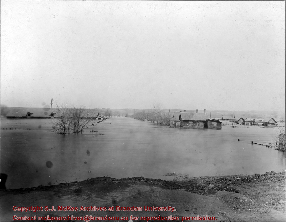
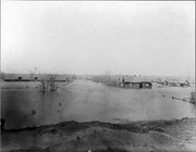
The "flats" refers to the Assiniboine River floodplane from 18th Street to First Street on either side of the river. See p. 223 of G.F. Barker's Brandon: A City for a description of the 1922 flood.
Custodial History
The photo was owned by Mrs. Wes Railton prior to its donation to the Archives.
Scope and Content
Photograph contains an image of houses on the Assiboine floodplane (Brandon's "flats") submerged in flood-waters.
Name Access
Brandon
Assiniboine River
Subject Access
northend
floods
natural phenomena
Storage Location
BAPC oversize storage drawer
Images
Show Less

Street scene 8th Street in winter

http://archives.brandonu.ca/en/permalink/descriptions13704
Part Of
Fred McGuinness collection
Description Level
Item
GMD
graphic
Date Range
1906
Accession Number
20-2009
Part Of
Fred McGuinness collection
Description Level
Item
Series Number
McG 9
Item Number
20-2009.14
Accession Number
20-2009
GMD
graphic
Date Range
1906
Physical Description
4.25" x 3.25" (b/w)
Material Details
on matting
Physical Condition
Photograph has been glued to a backing board that has warped over time
History / Biographical
On 16 November 1906, Manitoba was hit by a severe winter storm that began that Thursday evening and extended through the weekend. The Brandon Daily Sun ("Storm Extends Over a Large Territory," 17 Nov. 1906, 1) reported that rail and telegraph services had been disrupted, country roads were impassable, and business in town was at a stand still. Following the weekend, the daily reported the blizzard was one of the greatest in recent memory. CPR trains had been caught in drifts by Carberry and an express car had caught fire and was destroyed ("Worst Storm in Many Years," Brandon Daily Sun, 19 Nov. 1906, 1).
Scope and Content
Photograph shows street view of intersection of the 000 block of 8th Street and Rosser Avenue in the winter. Businesses on the east side of 8th Street from Pacific to Rosser Avenues are clearly visible and include: a Lunch Room (likely Aagaard's Lunch Counter), the Hotel Imperial Annex, Liverpool House (a boarding house), R.S. Thompson and Company Real Estate Office (Land Office), a barber shop (likely J. Coulter's), Frank Gowen photography studio. Fleming's Drug Store on the corner of 8th Street and Rosser Avenue has been replaced by the Bank of Hamilton. The Imperial Hotel is visible on the west side of 8th Street. The 8th Street Bridge is visible in the background. Men in winter coats and hats are crossing the street at the intersection. A horse-drawn sleigh is parked on 8th Street.
Notes
Writing on the front of the photograph matting reads: 340, after the storm November 1906. Page appears to be from a photo album. The photograph appears to be taken from the interior of a builing on the southwest corner of 8th Street and Rosser Avenue.
Name Access
Fleming Block
Frank Gowen Photographer
Liverpool House
Hotel Imperial Annex
8th Street
Rosser Avenue
Aagaard's
R.S. Thompson
8th Street Bridge
Bank of Hamilton
Imperial Hotel
Subject Access
Street scene
downtown
storefronts
store exteriors
hotels
boarding houses
barber shops
restaurants
druggists
photographers
bridges
banks
winter
Transportation
sleighs
storms
land agents
Storage Location
RG 5 photograph storage drawer 2 (hanging photos)
Images
Show Less

Wright & Wright, Brandon

http://archives.brandonu.ca/en/permalink/descriptions13949
Part Of
Fred McGuinness collection
Description Level
Item
GMD
graphic
Date Range
1882
Accession Number
1-2015
Part Of
Fred McGuinness collection
Description Level
Item
Series Number
McG 9
Item Number
1-2015.21
Accession Number
1-2015
GMD
graphic
Date Range
1882
Physical Description
5" x 4" (b/w)
Material Details
reproduction
Scope and Content
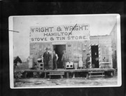
Photograph shows four men posing in front of a wood-framed shop on 8th Street and Rosser Avenue. The men are wearing three-piece suits or vests and long-sleeved shirts. A painted sign above the shop reads: Wright & Wright, Hamilton Stove & Tin Store. Hanging from the exterior walls are various tin items for sale: lantern, ladel, dust pan, pots and pans.
Notes
Writing on the back of the photograph reads: Corner of 8th & Rosser. Photograph is stamped Public Archives Canada.
Name Access
8th Street
Rosser Avenue
Subject Access
Pioneers
store exteriors
Brandon business buildings & facilities before 1940
Storage Location
RG 5 photograph storage drawer 2 (hanging photos)
Related Material
LAC, Mikan 3194057
Arrangement
See McG 4.1 File 51 William R. Morrison correspondence dated 14 January 1985
Images
Show Less

20 records – page 1 of 1.