Corners of photograph mat are bent. Picture is cracked.
Scope and Content
Photograph shows an early view of Brandon's 6th Street in the 1880s. The Winter & O'Neail Groceries & Provisions and James Smart Hardware storefronts have been photographed. A street sign designating 6th Street can be seen below the Winter & O'Neail sign. A horse and cart is parked in front of the grocery store. A number of men wearing hats and jackets are standing along the boardwalk while posing for the picture. Lumber/timber saws are displayed in teh windows of the hardware store.
Notes
Front of photograph reads: 6th Street, Brandon, Manitoba, 1881-1882, Entrance [to Winter & O'Neail] corner of Rosser Ave & 6th Street.
Photograph mat is bent. Emulsion problems with image.
Scope and Content
Photograph shows Rosser Avenue in its incipient stages. Canvas tents are mixed amongst wooden structures. The James Smart Hardware store, Winter & O'Neail Groceries & Provisions, and the law office of F.G.A. Henderson in the Molesworth Block can be seen on the north side of Rosser Avenue. A street sign designating 6th Street can be seen below the Winter & O'Neail sign. A horse and buggie is traveling down the dirt track that is Rosser Avenue. Groups of men can be seen congregating outside some of the local businesses.
Notes
Front of photograph reads: Rosser Avenue, Brandon 1882-1883, from east of Six Street. Back of photograph is stamped: I. Bennetto & Co., Photographers, Opposite Post-Office, Winnipeg, Man.
Photograph shows the Brandon Wheat Market along Pacific Avenue on November 30, 1885. Farmers can be seen driving wagon teams loaded with bags of grain in line on Pacific Avenue from 10 Street to at least 7th Street. On the north side of Pacific Avenue the CPR Land Office and grain elevators are pictured. On the south side of Pacific Avenue, the general merchant/hardware store Bower, Blackburn, Mundell & Porter is situated on the corner of Pacific Avenue and 10th Street. A 10th Street sign is affixed to the merchants' store. On the east side of the general store, Edie House, the Grand View Hotel, and a Farmers' boarding and lodging house can be seen. Most of the buildings appear to be woodframed except for the Grand View, which is constructed of brick. Sidewalks appear to be in place on the south side of Pacific and snow dusts the streets. A baby swathed in winter clothing sits in a pram/baby carriage in front of the general store.
Notes
Writing on the front of the photograph reads: Novemeber 30th, 1885, Brandon Wheat Market
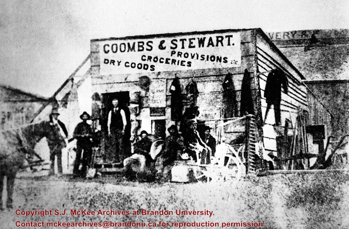
This store, the first established in Brandon (June 12, 1881), was erected on the southeast corner of 6th St. & Pacific Avenue, facing Pacific.
Coombs and Steward later opened a store on the northeast corner of 9th St. & Rosser Ave.
Billy Muir was Coombs & Stewart's first clerk. He later opened a store of his own on the west side of the 100 block of 6th St., which he operated for nearly 50 years. (I was often a customer as a kid - LAS). Billy Muir closed his 6th Street store June 1945 (Brandon Sun). [See E18]
Custodial History
For custodial history see the collection level description of the Lawrence Stuckey collection.
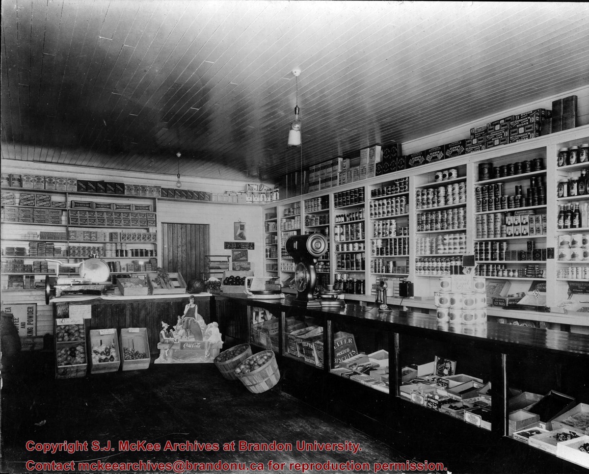
Thompson's Groceries and Confectionary was established in 1923 by Arthur Thompson (b. 1881 - d. May14, 1957) at 764 13th Street. From approximately 1925-1927, the store was operated by Alexander Thompson at 762 13th Street. The fate of the store from 1929-1935 is unclear. In 1929, Alexander Thompson was a grocer at 748 7th Street and in 1931 a Mrs. A Thompson was a grocer at 802 14th Street. There were two Thompson grocery and confectionary businesses in Brandon in 1933: Thompson's Confectionary at 745 13th Street and Thompson & Co. at 702 12th Street. In 1935, Arthur Thompson appears to have either taken over one of the earlier businesses or reopened his own grocery in its original location at 762 13th Street. He operated his store at this location into the mid-1950s. At some point following Thompson's death the building was bought by Frank Fitzpatrick and used for his upholstery store.
Custodial History
Donated by Frank Fitzpatrick.
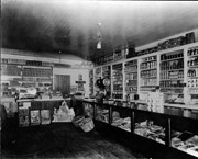
Scope and Content
Photograph shows the interior of Thompson's Grocieries and Confectionary.
Notes
History/Bio information taken from Henderson's Directories (1917-1955) for Brandon, MB.
Photograph shows the 800 block of Rosser Avenue facing west. On the south side of Rosser Avenue the Nation Block, Christie's Bookstore, and Reesor's Clock can be seen. A number of horse and buggies/carriages are travelling along Rosser Avenue.
For custodial history see the collection level description of the Lawrence Stuckey collection.
Scope and Content
Northwest corner of Tenth Street and Rosser Avenue
Notes
Showing (left to right): Fraser Building 1890, John E. Smith Block 1907, The Canadian Bank of Commerce 1907, Cecil Hotel 1910, Brandon Sun Building 1905; Can be dated by Cecil Hotel (built 1910) and because the streets were paved and streetcar tracks laid in 1912.
Photograph shows a panorama, bird's-eye-view of downtown Brandon, between Pacific and Rosser Avenues and 7th Street facing east. Photoraph likely taken from the McKenzie Seeds Building. Visible businesses include: Western Canada Flour Mills, Hanbury Hardware Co. Ltd., Cockshutt Plow Co., New Pacific Hotel, Gordon McKay Building, and Arlington Hotel.
Notes
Part of "Souvenir of Brandon, Manitoba, Canada [viewbook], Printed by Photogelatine Engraving Co. Limited, Ottawa." Dates obtained from the Burchill's Music Store Henderson's Brandon City Directory listings (1927-1929). Writing on the front of the photograph reads: Panorama of Brandon, Man.
Photograph shows a southwest view of the Prince Edward Hotel and train station.
Notes
Part of "Souvenir of Brandon, Manitoba, Canada [viewbook], Printed by Photogelatine Engraving Co. Limited, Ottawa." Dates obtained from the Burchill's Music Store Henderson's Brandon City Directory listings (1927-1929). Writing on the front of the photograph reads: Prince Edward Hotel, Brandon, Man.
Photograph shows Princess Avenue facing east from 10th Street. On the north side of Princess Avenue, a B/A Service Station, Princess Cafe, Lindenberg Seeds, and the Central Fire Station are visible. Old City Hall with the war memorial and the Prince Edward Hotel are visible on the south side of Princess Avenue. Traffic is travelling one-way on Princess Avenue.
The Strome & White Co. General Store (L. foreground; built 1902) became Brandon Hardware & Brandon Hardware block, later Ashdowns; The final tenant was Stylerite Hardware with two floors of residential suites. It was destroyed by fire March 27, 1983
Custodial History
For custodial history see the collection level description of the Lawrence Stuckey collection.
Scope and Content
View of Rosser Avenue, looking east from Seventh Street
Photograph is scratched and has been glued to a backing board that has warped over time
Scope and Content
Photograph shows street view of the northeast intersection of the 000 block of 8th Street and Rosser Avenue. Horse and buggies are parked along the east side of 8th Street. Businesses on the east side of 8th Street from Pacific to Rosser Avenues are clearly visible and include: a Lunch Room (likely Aagaard's Lunch Counter), the Hotel Imperial Annex, Liverpool House (a boarding house), R.S. Thompson and Company Real Estate Office (Land Office), a barber shop (likely J. Coulter's), Frank Gowen photography studio, and Fleming's Drug Store. A possible street fair is in progress on Rosser Avenue. One man is standing on a soap box and is surrounded by a crowd in the middle of 8th Street. Another man can be seen standing behind a booth on the northwest street corner. Building construction appears to be happening on the west corner of 8th Street and Rosser Avenue.
Notes
Writing on the front of the photograph matting reads: 297. One photograph (20-2009.80) is glued below the photograph. Another photograph is glued on the reverse side. Page appears to be from a photo album.
Photograph is scratched and has been glued to a backing board that has warped over time
Scope and Content
Photograph shows street view of intersection of the 000 block of 8th Street and Rosser Avenue. Horse and buggies are travelling on both roads. Businesses on the east side of 8th Street from Pacific to Rosser Avenues are clearly visible and include: a Lunch Room (likely Aagaard's Lunch Counter), the Hotel Imperial Annex, Liverpool House (a boarding house), R.S. Thompson and Company Real Estate Office (Land Office), a barber shop (likely J. Coulter's), Frank Gowen photography studio, and Fleming's Drug Store. A possible street fair is in progress on Rosser Avenue. One man is surrounded by a crowd adjacent to the Fleming Block, another man stands on a soap box in the middle of the intersection, while a third man is standing behind a booth. Building construction appears to be happening on the west corner of 7th Street and Rosser Avenue.
Notes
Writing on the front of the photograph matting reads: 296. One photograph (20-2009.12) is glued above and two others are glued on the reverse side. Page appears to be from a photo album.


)