For custodial history see the collection level description of the Lawrence Stuckey collection.
Scope and Content
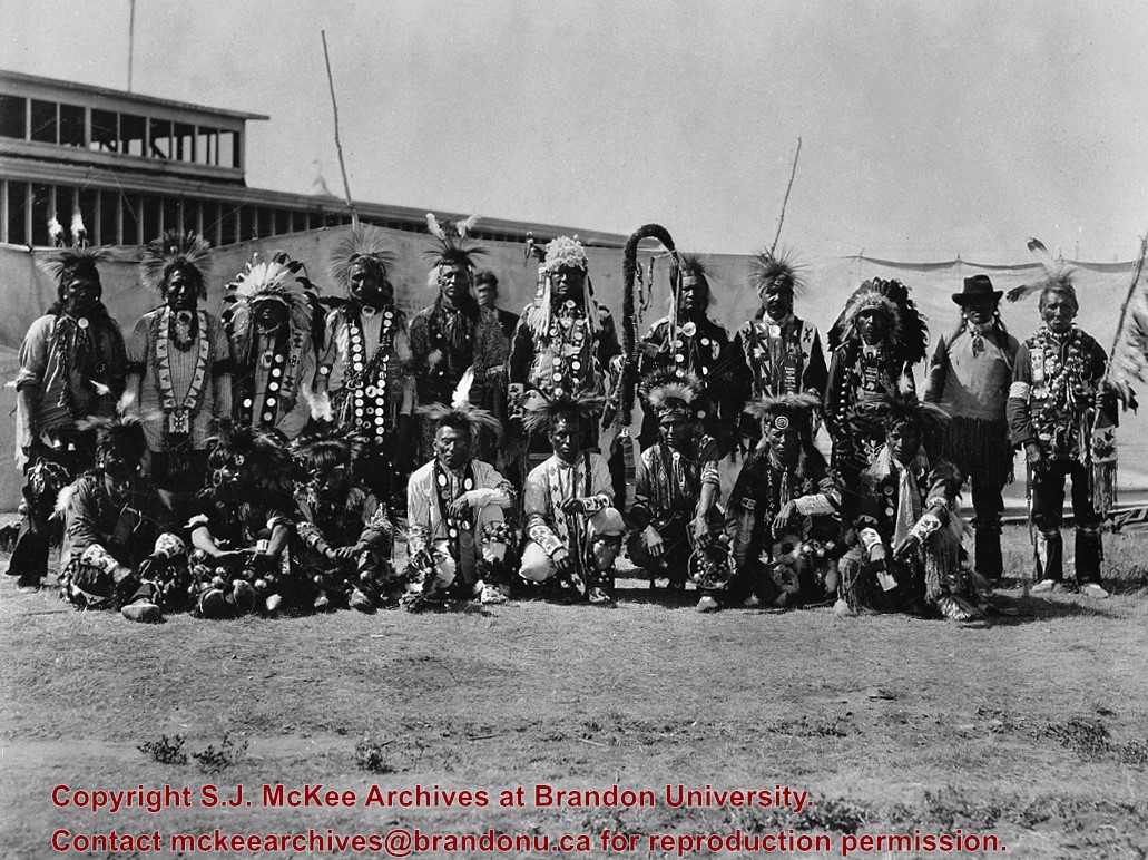
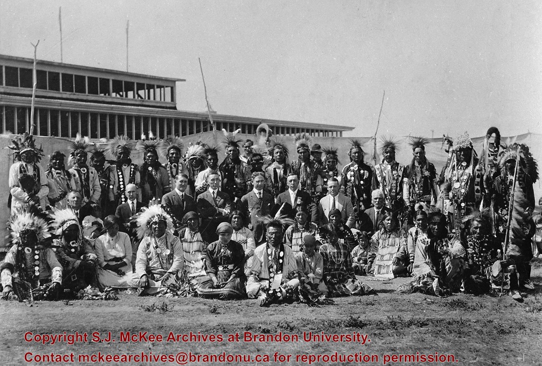
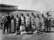
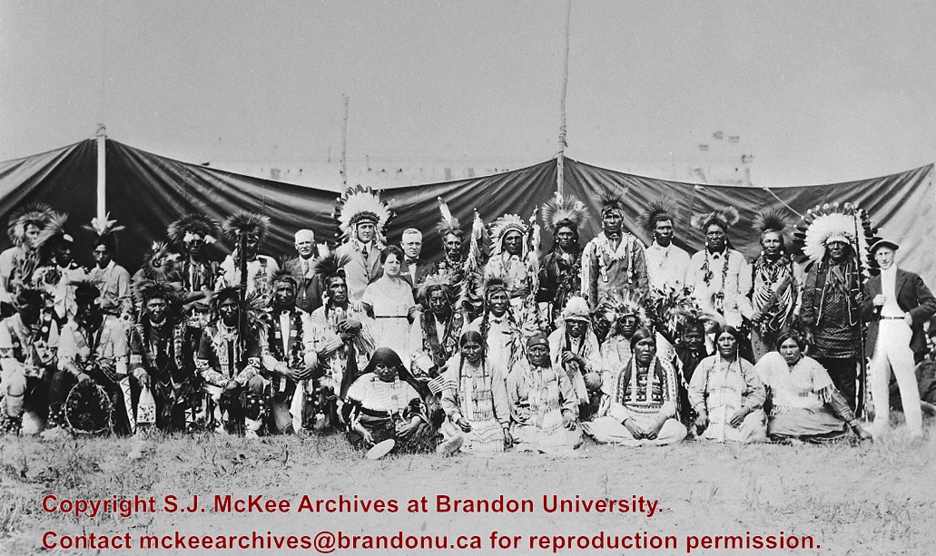
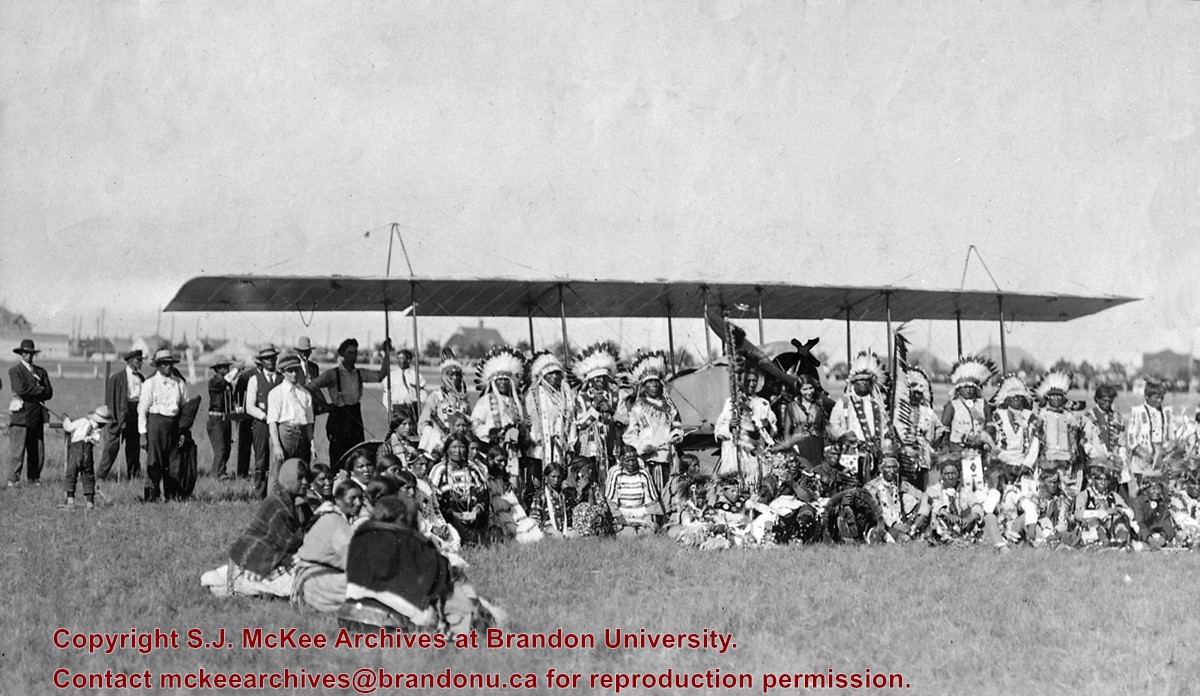
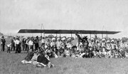
Katherine Stinson & aircraft with Indigenous peoples
Notes
Photo taken in Brandon, Manitoba
Miss Stinson was half Indigenous
See Lawrence Stuckey file (Finding Aids) for biography of Katherine Stinson.
[Please note that in the title we have chosen to maintain the original terminology used by Mr. Stuckey in order to maintain the original context and order of the record. P.E. 08/07/09.]
Photograph shows the Red Indian (Gasoline) Station on the north side Princess Avenue between 9th and 10th Streets, Brandon. Attached to the west side of the gas station is another shop which contains Hutchings' Drug Store. The Alexandra Block on 10th Street is visible in the background.
Photograph shows the Greyhound Bus Depot at 11th Street and Princess Avenue. Western Motors, Wheelers Esso Station, and the Prince Edward Hotel are visible along the south side of Princess Avenue. Traffic is travelling one-way on Princess Avenue.
Photograph shows Western Motors Ltd. on the southwest corner of 10th Street and Princess Avenue. To the west of the car dealership/garage is the Greyhound Bus Station and its Maxwell House Cafe as well as the court house.
Photograph shows Western Motors Ltd. on the southwest corner of 10th Street and Princess Avenue. Anglo gas station is part of the car shop, which sells GM, Chevrolet, and Oldsmobiles.
Hutchings' Drugs is on the ground floor of the Hughes Building on the northwest corner of 10th Street and Princess. Manufacturers Life occupies the second storey.
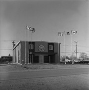
Photograph shows the north face of the Prince Edward Hotel on Princess Avenue. To the east of the hotel is Old City Hall with the military monument (which has since been relocated to the Brandon Armoury). On the west side of the hotel is Wheelers Esso Service Station.
Notes
The photograph appears to be taken from the Hughes Building on 10th Street.
Photograph shows the west side of the 200-block on 10th Street. Visible businesses include: Chamber of Commerce Tourist Information, Dominion Tire & Radio Co., Bonnie's Bonnet Shop, Steve's Grill, Wally's Taxi, and Western Motors Ltd. The painted advertisement for Doig, Rankin and Robertson is visible on the Alexandra Block. Christmas ornaments are displayed from light standards and include Santa Claus and a Christmas elf.
Photograph shows the west side of the 200-block on 10th Street. Visible businesses include: Chamber of Commerce Tourist Information, Dominion Tire & Radio Co., Steve's Grill, Wally's Taxi, and the garage entrances to Western Motors Ltd. A Santa Claus Christmas ornament is displayed from a light standard.
Photograph shows Princess Avenue facing east from 10th Street. On the north side of Princess Avenue, a B/A Service Station, Princess Cafe, Lindenberg Seeds, and the Central Fire Station are visible. Old City Hall with the war memorial and the Prince Edward Hotel are visible on the south side of Princess Avenue. Traffic is travelling one-way on Princess Avenue.
The Medicine Hat Exhibition and Stampede Parade Day was held on Thursday, July 19, 1962, at 9:30 a.m. The local newspaper reported that approximately 24,000 people were in attendance to see parade marshall Rod Ashburner leading 175 entries consisting of 90 floats, 75 horses, and 10 bands. There were 19 parade categories eligible for $12,000 in prize money and included: junior and senior cowboys and cowgirls; fancy and Shetland ponies; sulky class open; comic, commercial, industrial and organizational floats; decorated cars; special ranch class; 4-H Clubs; and a non-competitive class.
The parade route started at Second St. and Allowance Ave., from Second St. to Ash Ave., north on Ash to First St. SE., from First St. S.E. to Fourth Ave., south to Second St. to South Railway St., south on South Railway St. to Third St., with a finish at McLeod Trail. A route map was published in the Medicine Hat News the day before the parade.
Aerial photographs of the parade were taken by Medicine Hat News photographer Howard Heid (1930-2005) from the private helicopter of John Bourn. Bourn was a pilot from Woodville, Wisconsin, who chartered his four-seater helicopter for sight-seers at exhibitions and stampedes across the county.
(Sources: Pat Currie, "Let 'Er Go!," Medicine Hat News, 19 July 1962,1; Harald Gunderson, "'Eye in the Sky' Best Parade View," Medicine Hat News, 19 July 1962,1; "Parade Starts at 9:30 Sharp," 18 July 1962)
Scope and Content
Photograph shows an aerial view of the Medicine Hat Exhibition and Stampede Parade route with a focus on the First Street SE and Sixth Avenue intersection. A number of gas stations and garages are visible along this route and include Texaco, Shell, Ford, and B/A. A number of observers can be seen sitting on rooftops.
Notes
This photograph shows the neighbourhood before rezoning and commercial development.
The Medicine Hat Exhibition and Stampede Parade Day was held on Thursday, July 19, 1962, at 9:30 a.m. The local newspaper reported that approximately 24,000 people were in attendance to see parade marshall Rod Ashburner leading 175 entries consisting of 90 floats, 75 horses, and 10 bands. There were 19 parade categories eligible for $12,000 in prize money and included: junior and senior cowboys and cowgirls; fancy and Shetland ponies; sulky class open; comic, commercial, industrial and organizational floats; decorated cars; special ranch class; 4-H Clubs; and a non-competitive class.
The parade route started at Second St. and Allowance Ave., from Second St. to Ash Ave., north on Ash to First St. SE., from First St. S.E. to Fourth Ave., south to Second St. to South Railway St., south on South Railway St. to Third St., with a finish at McLeod Trail. A route map was published in the Medicine Hat News the day before the parade.
Aerial photographs of the parade were taken by Medicine Hat News photographer Howard Heid (1930-2005) from the private helicopter of John Bourn. Bourn was a pilot from Woodville, Wisconsin, who chartered his four-seater helicopter for sight-seers at exhibitions and stampedes across the county.
(Sources: Pat Currie, "Let 'Er Go!," Medicine Hat News, 19 July 1962,1; Harald Gunderson, "'Eye in the Sky' Best Parade View," Medicine Hat News, 19 July 1962,1; "Parade Starts at 9:30 Sharp," 18 July 1962)
Scope and Content
Photograph shows an aerial view of the Medicine Hat Exhibition and Stampede Parade route, with a focus on Second Street SE. Visible store signs include: Gardener's Used Cars, Provincial Treasury Branch, Furvey's Furniture and Appliances, J.J. Moore & Son Furniture, Alberta Credit Jewellers, James Richardson & Sons, Medicine Hat Gas Power Water City Owned Utilities.
Notes
This photograph shows the neighbourhood before rezoning and commercial development.
The Medicine Hat Exhibition and Stampede Parade Day was held on Thursday, July 19, 1962, at 9:30 a.m. The local newspaper reported that approximately 24,000 people were in attendance to see parade marshall Rod Ashburner leading 175 entries consisting of 90 floats, 75 horses, and 10 bands. There were 19 parade categories eligible for $12,000 in prize money and included: junior and senior cowboys and cowgirls; fancy and Shetland ponies; sulky class open; comic, commercial, industrial and organizational floats; decorated cars; special ranch class; 4-H Clubs; and a non-competitive class.
The parade route started at Second St. and Allowance Ave., from Second St. to Ash Ave., north on Ash to First St. SE., from First St. S.E. to Fourth Ave., south to Second St. to South Railway St., south on South Railway St. to Third St., with a finish at McLeod Trail. A route map was published in the Medicine Hat News the day before the parade.
Aerial photographs of the parade were taken by Medicine Hat News photographer Howard Heid (1930-2005) from the private helicopter of John Bourn. Bourn was a pilot from Woodville, Wisconsin, who chartered his four-seater helicopter for sight-seers at exhibitions and stampedes across the county.
(Sources: Pat Currie, "Let 'Er Go!," Medicine Hat News, 19 July 1962,1; Harald Gunderson, "'Eye in the Sky' Best Parade View," Medicine Hat News, 19 July 1962,1; "Parade Starts at 9:30 Sharp," 18 July 1962)
Scope and Content
Photograph shows an aerial view of the Medicine Hat Exhibition and Stampede Parade route with a focus on the First Street SE. A number of gas stations and garages are visible along this route and include Texaco, Shell, Ford, and B/A. The Fraternal Order of Eagles lodge is also visible.
Notes
This photograph appeared on the front page of The Medicine Hat News (19 July 1962).
The Medicine Hat Exhibition and Stampede Parade Day was held on Thursday, July 19, 1962, at 9:30 a.m. The local newspaper reported that approximately 24,000 people were in attendance to see parade marshall Rod Ashburner leading 175 entries consisting of 90 floats, 75 horses, and 10 bands. There were 19 parade categories eligible for $12,000 in prize money and included: junior and senior cowboys and cowgirls; fancy and Shetland ponies; sulky class open; comic, commercial, industrial and organizational floats; decorated cars; special ranch class; 4-H Clubs; and a non-competitive class.
The parade route started at Second St. and Allowance Ave., from Second St. to Ash Ave., north on Ash to First St. SE., from First St. S.E. to Fourth Ave., south to Second St. to South Railway St., south on South Railway St. to Third St., with a finish at McLeod Trail. A route map was published in the Medicine Hat News the day before the parade.
Aerial photographs of the parade were taken by Medicine Hat News photographer Howard Heid (1930-2005) from the private helicopter of John Bourn. Bourn was a pilot from Woodville, Wisconsin, who chartered his four-seater helicopter for sight-seers at exhibitions and stampedes across the county.
(Sources: Pat Currie, "Let 'Er Go!," Medicine Hat News, 19 July 1962,1; Harald Gunderson, "'Eye in the Sky' Best Parade View," Medicine Hat News, 19 July 1962,1; "Parade Starts at 9:30 Sharp," 18 July 1962)
Scope and Content
Photograph shows an aerial view of the Medicine Hat Exhibition and Stampede Parade route with a focus on the First Street SE and and the South Railway Street merge. A number of gas stations and garages are visible along this route and include Texaco, Shell, Ford, and B/A. The Fraternal Order of Eagles lodge is also visible.
Notes
This photograph shows the neighbourhood before rezoning and commercial development.
See RG 6 Brandon University fonds, Series 7 Faculties and Schools, Sub-series 7.1 Faculty of Arts, Sub sub series 7.1.1 Dean of Arts for biographical information for Michael Blanar.
Custodial History
Collection was in the possession of Dr. Michael Blanar until he donated the records to the S.J. McKee Archives in May 2002.
Scope and Content
Collection consists of textual records and five microfilm reels related to Dr. Blanar’s post-graduate research. It is assumed that the records were collected during the course of Blanar’s research for his dissertation entitled “Early British Travellers in French Canada (1960).”
Textual records include three Dominion of Canada notebooks containing handwritten Saulteaux verbs, and animate nouns. Included is a dark red booklet titled “Ojibwe.” The book contains Ojibwa translations of English words. The book comes from St. Peter Clavers Industrial School in Spanish, Ontario, and may have acted as an instructional book as it also contains French and English. Collection also contains a transcript of an Ojibwa dictionary and three file folders titled “Manuscripts,’ “John Long Research,” and “Maps” which contain additional research material. Contents of “Manuscript” folder are original typed manuscripts. “John Long” and “Maps” file folders contain copies of materials held at Library and Archives Canada, as well as hand drawn documents and hand written documents detailing contents of folders.
In addition to the textual records there are five microfilm reels. Three microfilm cases are labeled “The British Reference Division,” one case labeled “Public Archives Canada, central microfilm operations,” and the last case is from an unidentified source labeled “Longs voyages and travels”. Four of the five microfilm cases are also numbered. The British Reference Division microfilm case numbered “1346 i 43” contains a copy of a book titled “The Cacique of Ontario.” British Reference Division microfilm case numbered “104706640” contains a copy of a book titled “The Four Kings of Canada.” British Reference Division microfilm case numbered “9073279” contains a copy of a book titled “The Indians.” The Public Archives Canada microfilm case numbered “c-3006” contains copies of original documents in French and English. Documents include letters, diary pages, maps, and business ledgers. Microfilm case labeled “Longs voyages and travels” contains a copy of a book written by John Long titled “Voyages and Travels of Indian Interpreter and Trader.”
Notes
Description by Aaron McKay (October 2013). The Ojibwa language dictionary and notebook make references to Fredric Baraga (1797-1868), a missionary priest from Slovenia who recorded the Lake Superior Ojibwa language dialect. Baraga’s findings were published into an Ojibwa language dictionary.


+north+side+Princess+Avenue+between+9th+Street+and+10th+Street%2c+Brandon%2c+Manitoba)