For custodial history see the collection level description of the Lawrence Stuckey collection.
Scope and Content
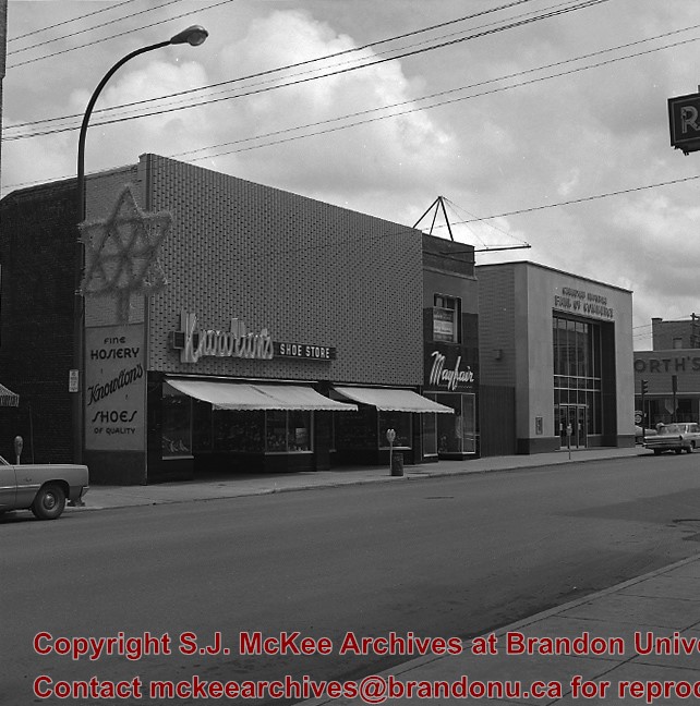
1000 block of Rosser Ave., north side. Showing (left to right): Public Library (ex. Merchants Bank of Canada) built 1906; [Smith's Tobacco Shop,]; A.C. Fraser Block built 1890; Scotia Towers built 1970's.
For custodial history see the collection level description of the Lawrence Stuckey collection.
Scope and Content
North side of Rosser Avenue, looking west from Ninth Street
Notes
Businesses (left to right): Leask & Ro___ General merchandise, Fortier & Bucke - Manufacturers' Agents and CPR Express Co., The New Era, Imperial Bank of Canada, Durand & Macdonald Law Office, T.D. McLean - jeweller, and J. Barker Vosburgh - Surgeon & Dentist. From Fred McGuinness.
The Brandon Club (L. of center) was built in 1904. This local businessmen's club met in the old firehall until this building was erected by them.
[The Brandon Club closed and its assets were sold at auction on 18 June 2005. P.E. 01/06/2009]
Custodial History
For custodial history see the collection level description of the Lawrence Stuckey collection.
Scope and Content
Overhead view of Princess Avenue, west of 10th Street
Notes
Taken from roof of Prince Edward Hotel. Shows: Rat Portage Lumber Co., St. Matthew's Hall, Brandon Club, In distance Brandon College, International Harvester, Pumping Station. End of brick pavement at 14th Street is notable.
For custodial history see the collection level description of the Lawrence Stuckey collection.
Scope and Content
View of Assiniboine Avenue running west, from Ninth Street North
Notes
Second building from right - Westbrook & Fairchild Implements. At left - Western Hotel; Data [courtesy of] Roy Brown from Henderson's [Directory]; From Manitoba Archives
For custodial history see the collection level description of the Lawrence Stuckey collection.
Scope and Content
View of the southeast corner of Tenth Street and Princess Avenue, showing the Prince Edward Hotel (left) and an Imperial Oil Building (right).
Notes
The second floor of the Imperial Oil building became the Imperial Dance Garden in 1934. The small wooden post in a concrete foundation in the centre of the intersection was called a "Silent Policeman". You were supposed to keep it on your left while making a left turn. They took quite a beating.
[Information in "Notes" provided by the Fred McGuinness collection (20-2009).]
[The land on which city hall stood in this photo is now known as Princess Park. P.E. 01/06/09]
Custodial History
For custodial history see the collection level description of the Lawrence Stuckey collection.
Scope and Content
Princess Avenue, showing City Hall & CKX radio tower
Notes
[View is from 9th Street looking east. P.E.]
"Radio towers of CKX on city hall grounds were 150 feet tall; Studio and transmitter were on the east side of city hall." - Fred McGuinness collection (20-2009).


.jpg?width=1200&404=no-img.jpg&watermark=wmk)
.jpg?width=180&404=no-img.jpg)
.jpg?width=1200&404=no-img.jpg&watermark=wmk)
.jpg?width=180&404=no-img.jpg)
.jpg?width=1200&404=no-img.jpg&watermark=wmk)
.jpg?width=180&404=no-img.jpg)


.jpg?width=1200&404=no-img.jpg&watermark=wmk)
.jpg?width=180&404=no-img.jpg)


.jpg?width=1200&404=no-img.jpg&watermark=wmk)
.jpg?width=180&404=no-img.jpg)


.jpg?width=1200&404=no-img.jpg&watermark=wmk)
.jpg?width=180&404=no-img.jpg)
.jpg?width=1200&404=no-img.jpg&watermark=wmk)
.jpg?width=180&404=no-img.jpg)
.jpg?width=1200&404=no-img.jpg&watermark=wmk)
.jpg?width=180&404=no-img.jpg)


.jpg?width=1200&404=no-img.jpg&watermark=wmk)
.jpg?width=180&404=no-img.jpg)
.jpg%3fmaxheight%3d1000%26maxwidth%3d1000%26watermark%3dwmk&description=600+and+700+blocks+of+Rosser+Avenue)
.jpg%3fmaxheight%3d1000%26maxwidth%3d1000%26watermark%3dwmk&description=1000+block+of+Rosser+Avenue)
.jpg%3fmaxheight%3d1000%26maxwidth%3d1000%26watermark%3dwmk&description=1000+block+of+Rosser+Avenue)
.jpg%3fmaxheight%3d1000%26maxwidth%3d1000%26watermark%3dwmk&description=Princess+Avenue+east+of+Tenth+Street)
.jpg%3fmaxheight%3d1000%26maxwidth%3d1000%26watermark%3dwmk&description=Pacific+Avenue+-+west+of+Tenth+Street)
.jpg%3fmaxheight%3d1000%26maxwidth%3d1000%26watermark%3dwmk&description=Pacific+Avenue+-+west+of+Tenth+Street)
.jpg%3fmaxheight%3d1000%26maxwidth%3d1000%26watermark%3dwmk&description=Pacific+Avenue+-+west+of+Tenth+Street)
.jpg%3fmaxheight%3d1000%26maxwidth%3d1000%26watermark%3dwmk&description=Pacific+Avenue+-+west+of+Tenth+Street)
.jpg%3fmaxheight%3d1000%26maxwidth%3d1000%26watermark%3dwmk&description=200+block+of+Tenth+Street)