Skip header and navigation

Revise Search

20 records – page 2 of 1.

Brandon Cross of Sacrifice, Brandon Municipal Cemetery

http://archives.brandonu.ca/en/permalink/descriptions13860
Part Of
Fred McGuinness collection
Description Level
Item
GMD
graphic
Date Range
1926-1928
Accession Number
20-2009
Part Of
Fred McGuinness collection
Description Level
Item
Series Number
McG 9
Item Number
20-2009.171
Accession Number
20-2009
GMD
graphic
Date Range
1926-1928
Physical Description
5" x 7" (b/w)
Material Details
reproduction
History / Biographical
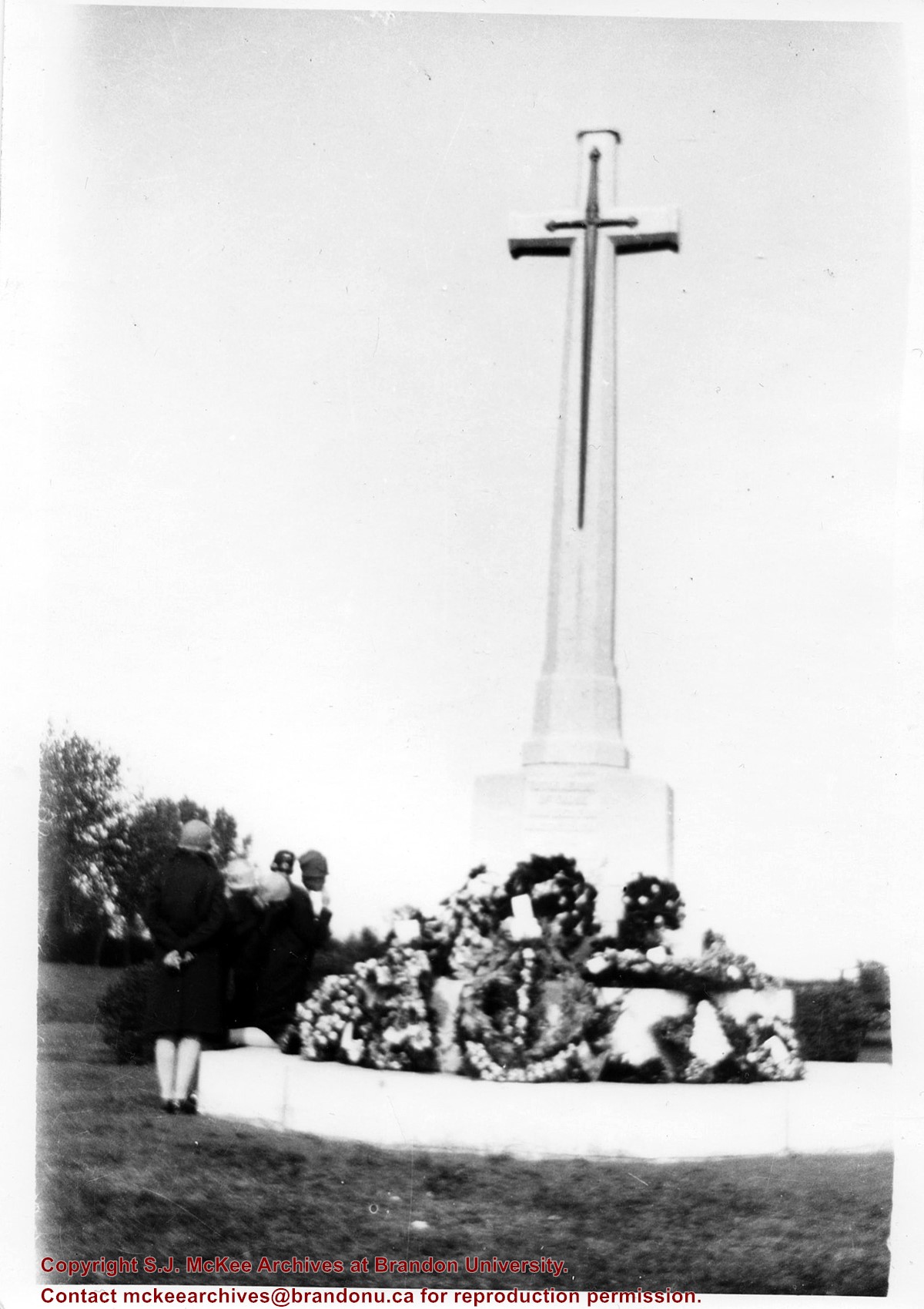
According to Veterans' Affairs Canada, there are 25 Crosses of Sacrifice in North America. The crosses were designed by the Canadian War Graves Commission's (CWGC) architect Sir Reginald Bloomfield, who designed a stone cross affixed with a bronze symbolic sword. The CWGC granted the Brandon Municipal Cemetery permission to privately erect the Cross of Sacrifice in its cemetery in exchange for maintaining the war graves in its cemetery. The Brandon Great War Veterans Association erected the Cross of Sacrifice in the Brandon Municipal Cemetery in 1924 after a 10-day public fundraising campaign. At the time the Brandon Daily Sun reported that the Veterans Association required $5,000 to pay for the cross and the campaign ultimately raised $7,500. The memorial was initially dedicated to the local citizens who died as a result of the First World War.
Custodial History
Donated to Fred McGuinness by G. Baldock in 1971
Scope and Content
Photograph is of a group of people examining wreaths that have been laid at the base of the Cross of Sacrifice in the Brandon Municipal Cemetery during a memorial service.
Name Access
Cross of Sacrifice
Brandon Municipal Cemetery
Subject Access
ceremonies
World War One
memorials
monuments
World War I
cemeteries
Storage Location
RG 5 photograph storage drawer 2 (hanging photos)
Arrangement
From 2009 loose photos, from File 13
Images
Show Less
Part Of
Fred McGuinness collection
Description Level
Sub-series
GMD
textual records
Date Range
c. 1966 - 2010
Accession Number
1-2015
Other Title Info
Title based on the contents of the subseries
Part Of
Fred McGuinness collection
Description Level
Sub-series
Series Number
McG 2.2
Accession Number
1-2015
GMD
textual records
Date Range
c. 1966 - 2010
Physical Description
Approximately 63.5 cm of textual records
History / Biographical
In November 1966, McGuinness was hired as vice-president to the Brandon Sun. He moved to Brandon with his family and had a career with the paper until his death in 2011. During his years with the Sun, McGuinness wrote a tri-weekly “Sunbeams” (sometimes spelled “Sun Beams”) column using the nom-de-plume F.A. [Fifth And] Rosser. Sunbeams was similar to McGuinness’ “Lighthouse” column for The Medicine Hat News; commenting on a variety of current events, Sunbeams also included book reviews, local events, and reminiscences. Upon his retirement in January 1987, McGuinness was made publisher emeritus of the Brandon Sun. A week after his retirement, he began writing a new column for the Sun, called the “Diary.” Initially a bi-weekly column, which was made into a weekly column in 2009, McGuinness continued writing the “Diary” until his hospitalization in 2010. The Diary column was primarily a historical retrospective of Brandon, although it also touched on broader topics of interest to McGuinness during the time period.
Custodial History
Accession 1-2015 contains records created and collected over the course of McGuinness’ career as a newspaper journalist and freelance writer. The Estate of Fred McGuinness donated the materials to the SJ McKee Archives circa 2011. The Archives accessioned the records in 2015.
Scope and Content
The subseries contains records created and collected by Fred McGuinness during his time as a journalist, editor, and freelance writer with the Brandon Sun. The records consist of scrapbooks of Sunbeams columns, Sunbeam drafts, Diary drafts, article proofs, column research, and correspondence.
Notes
Readers’ correspondence pertaining to McGuinness’ time with the Brandon Sun can be found in Fred McGuinness’ personal papers, subseries McG 1.2 Correspondence. Possible research for his Sunbeam and Diary columns may be found in McG 4.1 Local history research and McG 2.3 Neighborly News (File 3)
Accruals
Closed
Finding Aid
A file level inventory is available
Storage Location
2015 accessions
Arrangement
Arrangement was artificially created by the Archives. Subseries has been re-arranged according to publication period
Documents

McG 2_2 Brandon Sun inventory.pdf

Read PDF Download PDF
Show Less
Part Of
Fred McGuinness collection
Description Level
Item
GMD
graphic
Date Range
1955
Accession Number
1-2015
Part Of
Fred McGuinness collection
Description Level
Item
Series Number
McG 9
Item Number
1-2015.232
Accession Number
1-2015
GMD
graphic
Date Range
1955
Physical Description
5" x 3.5" (b/w)
Custodial History
Photograph given to Fred McGuinness by J. Bilinski of Brandon
Scope and Content
Photograph shows flood waters covering a road. Telephone poles show water marks designated flood levels.
Notes
Writing on the back of the photograph reads: Flood 55, Over 18th St., J. Bilinski RR#1 Bdn MB
Name Access
Brandon
City of Brandon
18th Street
Subject Access
floods
disasters
Storage Location
RG 5 photograph storage drawer 2 (hanging photos)
Arrangement
Cigar box photographs
Images
Show Less

Brandon University campus

http://archives.brandonu.ca/en/permalink/descriptions8026
Part Of
Aerial views and campus photographs
Description Level
Item
GMD
graphic
Date Range
c. 1996
Part Of
Aerial views and campus photographs
Description Level
Item
Series Number
2.1
Item Number
2.1.93
GMD
graphic
Date Range
c. 1996
Physical Description
6" x 4" (colour)
Scope and Content
View is east northeast from the sidewalk on the southeast corner of the George T. Richardson Centre (John R. Robbins Library). Photographs shows the campus during winter, including the Physical Plant and Development H-Huts, as well as the Brandon College Building and Clark Hall after the majority of the renovations were completed.
Images
Show Less

Brandon University campus

http://archives.brandonu.ca/en/permalink/descriptions8027
Part Of
Aerial views and campus photographs
Description Level
Item
GMD
graphic
Date Range
c. 1985
Part Of
Aerial views and campus photographs
Description Level
Item
Series Number
2.1
Item Number
2.1.94
GMD
graphic
Date Range
c. 1985
Physical Description
5" x 3.5" (colour)
Scope and Content
View is southwest from 18th Street, just north of the Brandon University sign. Tken during the summer, the photograph shows the front lawn, a portion of the flower bed, the Citizens' Science Building, the Knowles Douglas Students' Union Centre, the John R. Brodie Science Centre and McMaster Hall.
Images
Show Less

Brandon University campus

http://archives.brandonu.ca/en/permalink/descriptions8028
Part Of
Aerial views and campus photographs
Description Level
Item
GMD
graphic
Date Range
c. 1980s
Part Of
Aerial views and campus photographs
Description Level
Item
Series Number
2.1
Item Number
2.1.95
GMD
graphic
Date Range
c. 1980s
Physical Description
5" x 3.5" (colour)
Scope and Content
View is northeast. Photograph shows the green space before the Library extension in 1993. Brandon College Building and the Development H-Hut in the background.
Images
Show Less

Brandon University campus

http://archives.brandonu.ca/en/permalink/descriptions8029
Part Of
Aerial views and campus photographs
Description Level
Item
GMD
graphic
Date Range
c. 1988
Part Of
Aerial views and campus photographs
Description Level
Item
Series Number
2.1
Item Number
2.1.96
GMD
graphic
Date Range
c. 1988
Physical Description
5" x 3.5" (colour)
Scope and Content
View is northwest from the roof of the John R. Brodie Science Centre. Photograph shows part of McMaster Hall, the H-Huts, the Citzens' Science Building, the Brandon College Building and Clark Hall, the driveway, the J.R.C. Evans Lecture Theatre, the A.E. McKenzie Building and the Queen Elizabeth II Music Building.
Images
Show Less

Brandon University campus

http://archives.brandonu.ca/en/permalink/descriptions8030
Part Of
Aerial views and campus photographs
Description Level
Item
GMD
graphic
Date Range
c. early 1990s
Part Of
Aerial views and campus photographs
Description Level
Item
Series Number
2.1
Item Number
2.1.97
GMD
graphic
Date Range
c. early 1990s
Physical Description
4" x 6" (b/w)
Scope and Content
View is north from the Knowles Douglas Students' Union Centre looking down the driveway toward Princess Avenue.
Images
Show Less

Brandon University campus

http://archives.brandonu.ca/en/permalink/descriptions8031
Part Of
Aerial views and campus photographs
Description Level
Item
GMD
graphic
Date Range
c. 1995
Part Of
Aerial views and campus photographs
Description Level
Item
Series Number
2.1
Item Number
2.1.98
GMD
graphic
Date Range
c. 1995
Physical Description
6" x 4" (colour)
Scope and Content
View is northwest from the sidewalk on the west side of 18th Street. Photograph shows the John R. Brodie Science Centre sign, McMaster Hall and its entrance, the lawn in from of McMaster Hall, a portion of the Knowles Douglas Students' Union Centre and the Citizens' Science Building.
Images
Show Less

Brandon University campus

http://archives.brandonu.ca/en/permalink/descriptions8032
Part Of
Aerial views and campus photographs
Description Level
Item
GMD
graphic
Date Range
c. 2000
Part Of
Aerial views and campus photographs
Creator
Photographer: Sandy Black
Description Level
Item
Series Number
2.1
Item Number
2.1.99
GMD
graphic
Date Range
c. 2000
Physical Description
6" x 4" (colour)
Scope and Content
View is southwest from the corner of Clark Hall and the Clark Hall extension. Photograph shows students entering and exiting the George T. Richardson Centre and walking through the courtyard.
Images
Show Less

Brandon University campus

http://archives.brandonu.ca/en/permalink/descriptions8033
Part Of
Aerial views and campus photographs
Description Level
Item
GMD
graphic
Date Range
c. 1990s
Part Of
Aerial views and campus photographs
Description Level
Item
Series Number
2.1
Item Number
2.1.101
GMD
graphic
Date Range
c. 1990s
Physical Description
4" x 6" (colour)
Scope and Content
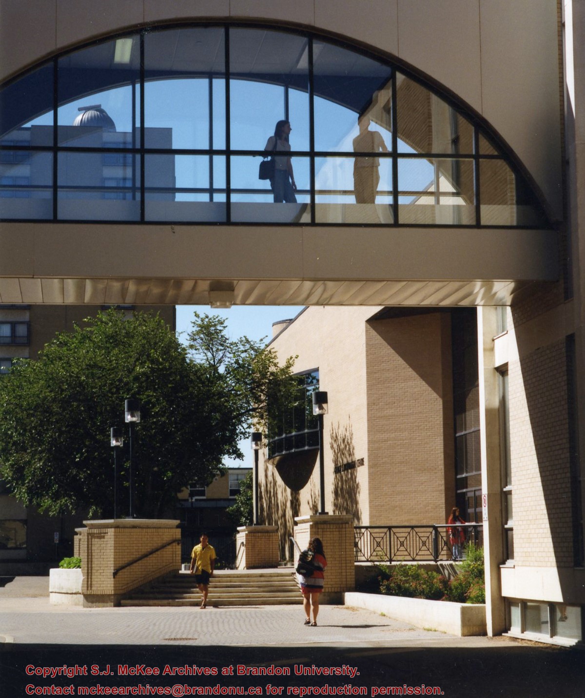
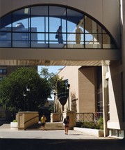
View is south from appromately the skywalk. Photograph shows the walkway that runs in front of the A.E. McKenzie Building south to the George T. Richardson Centre staircase and entrance. McMaster Hall in the background.
Images
Show Less

Brandon University campus

http://archives.brandonu.ca/en/permalink/descriptions8034
Part Of
Aerial views and campus photographs
Description Level
Item
GMD
graphic
Date Range
c. 2000
Part Of
Aerial views and campus photographs
Creator
Photograph: Sandy Black
Description Level
Item
Series Number
2.1
Item Number
2.1.102
GMD
graphic
Date Range
c. 2000
Physical Description
4" x 6" (colour)
Scope and Content
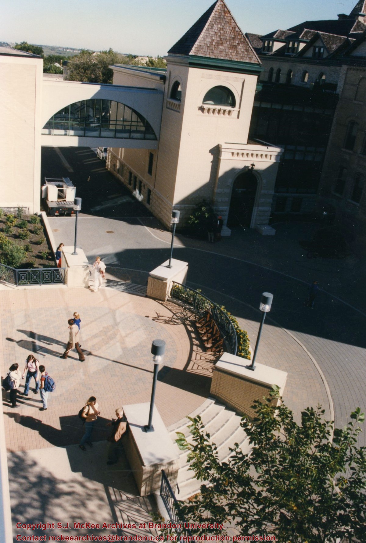
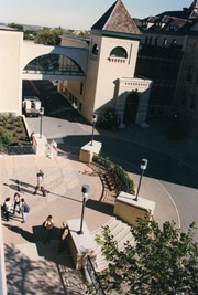
View is north northeast from the roof of the John E. Robbins Library in the George T. Richardson Centre. Photograph shows the entrance to the Richardson Building, part of the courtyard and the Clark Hall extension.
Images
Show Less

Brandon University campus

http://archives.brandonu.ca/en/permalink/descriptions8035
Part Of
Aerial views and campus photographs
Description Level
Item
GMD
graphic
Date Range
c. 2000
Part Of
Aerial views and campus photographs
Creator
Photographer: Sandy Black
Description Level
Item
Series Number
2.1
Item Number
2.1.103
GMD
graphic
Date Range
c. 2000
Physical Description
6" x 4" (colour)
Scope and Content
View is northeast from in front of the John E. Robbins Library in the George T. Richardson Centre. Photograph shows the entrance to the Richardson Building, most of the courtyard, Clark Hall and its extension.
Images
Show Less

Brandon University campus

http://archives.brandonu.ca/en/permalink/descriptions8036
Part Of
Aerial views and campus photographs
Description Level
Item
GMD
graphic
Date Range
c. 2000
Part Of
Aerial views and campus photographs
Creator
Photographer: Sandy Black
Description Level
Item
Series Number
2.1
Item Number
2.1.104
GMD
graphic
Date Range
c. 2000
Physical Description
6" x 4" (colour)
Scope and Content
View is northeast from the roof of the George T. Richardson Centre (John E. Robbins Library). Photograph shows the courtyard and the west side of the Brandon College building and Clark Hall, as well as the Clark Hall extension and part of the skywalk.
Images
Show Less

Brandon University campus

http://archives.brandonu.ca/en/permalink/descriptions8037
Part Of
Aerial views and campus photographs
Description Level
Item
GMD
graphic
Date Range
c. 2000
Part Of
Aerial views and campus photographs
Creator
Photographer: Sandy Black
Description Level
Item
Series Number
2.1
Item Number
2.1.105
GMD
graphic
Date Range
c. 2000
Physical Description
6" x 4" (colour)
Scope and Content
View is east southeast from the roof of the A.E. McKenzie Building. Photograph shows the courtyard and the west side of the Brandon College Building, as well as the Citizens' Science Building and the greenspace in between the two buildings.
Images
Show Less

Brandon University campus

http://archives.brandonu.ca/en/permalink/descriptions8038
Part Of
Aerial views and campus photographs
Description Level
Item
GMD
graphic
Date Range
c. 2000
Part Of
Aerial views and campus photographs
Creator
Photographer: Sandy Black
Description Level
Item
Series Number
2.1
Item Number
2.1.106
GMD
graphic
Date Range
c. 2000
Physical Description
4" x 6" (colour)
Scope and Content
View is from the front steps of the Education Building looking south down the east side of the Brandon College Building and Clark Hall to the Knowles Douglas Students' Union Centre and the John R. Brodie Science Centre in the background.
Images
Show Less

Brandon University campus

http://archives.brandonu.ca/en/permalink/descriptions8039
Part Of
Aerial views and campus photographs
Description Level
Item
GMD
graphic
Date Range
c. 2000
Part Of
Aerial views and campus photographs
Creator
Photographer: Sandy Black
Description Level
Item
Series Number
2.1
Item Number
2.1.107
GMD
graphic
Date Range
c. 2000
Physical Description
4" x 6" (colour)
Scope and Content
Photograph shows the Brandon College Building. It was taken from the sidewalk on 18th Street looking southwest across the front lawn.
Notes
Note on the back of the photograph reads "Please return photo to Sandy."
Images
Show Less

Brandon University campus

http://archives.brandonu.ca/en/permalink/descriptions8040
Part Of
Aerial views and campus photographs
Description Level
Item
GMD
graphic
Date Range
c. 2000
Part Of
Aerial views and campus photographs
Creator
Photographer: Sandy Black
Description Level
Item
Series Number
2.1
Item Number
2.1.108
GMD
graphic
Date Range
c. 2000
Physical Description
4" x 5" (colour)
Scope and Content
View is south. Photograph shows the skywalk and the steps leading to the entrance of the George T. Richardson Centre.
Images
Show Less

Brandon University campus

http://archives.brandonu.ca/en/permalink/descriptions8041
Part Of
Aerial views and campus photographs
Description Level
Item
GMD
graphic
Date Range
c. 1988
Part Of
Aerial views and campus photographs
Description Level
Item
Series Number
2.1
Item Number
2.1.110
GMD
graphic
Date Range
c. 1988
Physical Description
5" x 4" (colour)
Scope and Content
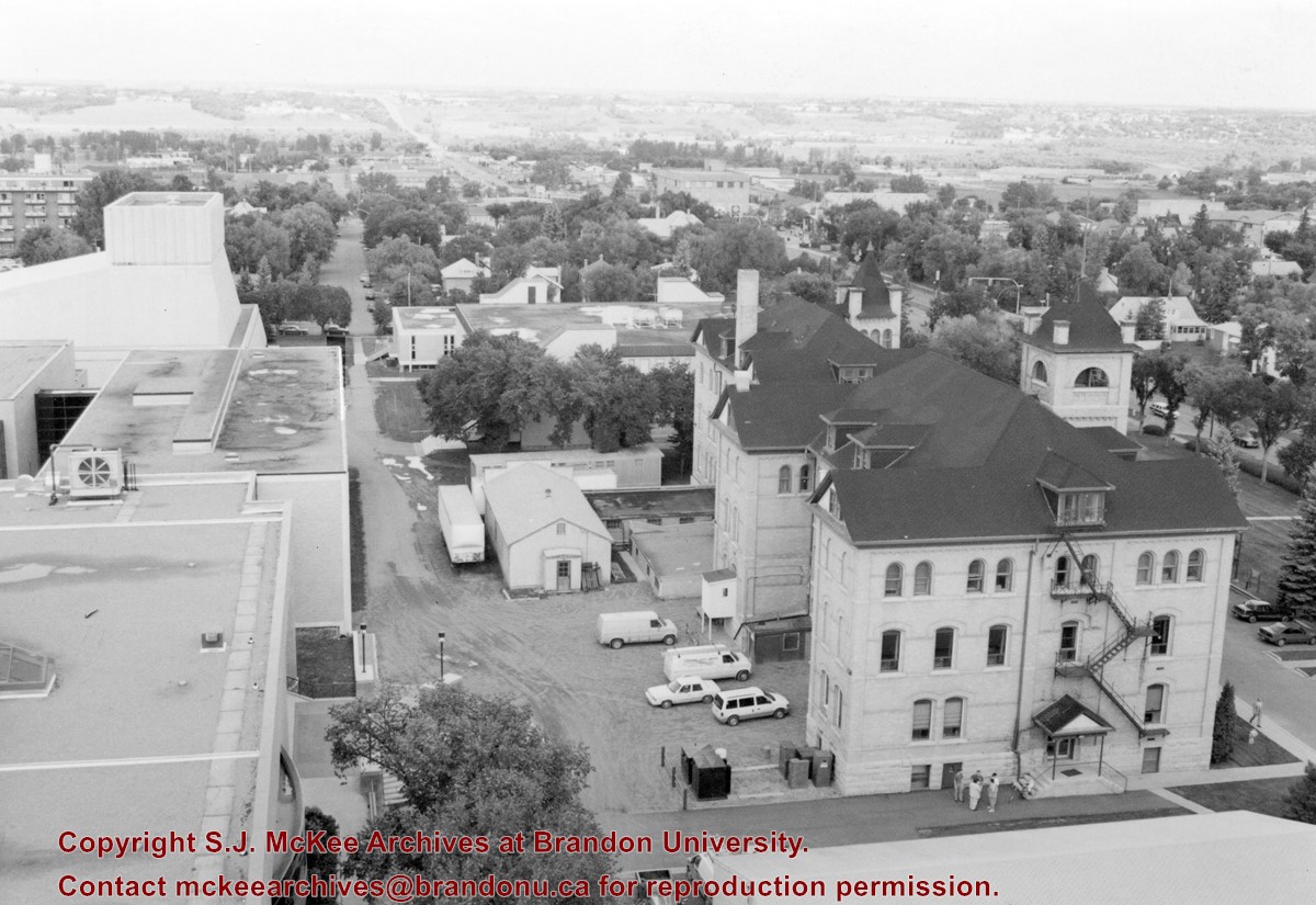
View is north northwest from the roof of McMaster Hall. Photograph shows part of the Citizens' Science Building, a number of H-Huts, the Brandon College Building, the greenspace, the J.R.C. Evans Lecture Theatre, the A.E. McKenzie Building, the Queen Elizabeth II Music Building and the Western Manitoba Centennial Auditorium. A number of residential blocks are also visible.
Images
Show Less

Brandon University campus

http://archives.brandonu.ca/en/permalink/descriptions8042
Part Of
Aerial views and campus photographs
Description Level
Item
GMD
graphic
Date Range
c. 1995
Part Of
Aerial views and campus photographs
Description Level
Item
Series Number
2.1
Item Number
2.1.111
GMD
graphic
Date Range
c. 1995
Physical Description
6" x 4" (b/w)
Scope and Content
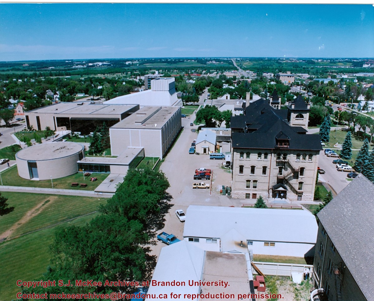
View is north northeast from the roof of McMaster Hall. Photograph shows a couple of H-Huts, the Brandon College Building, Clark Hall, the George T. Richardson Centre, the A.E. McKenzie Building, the original Music Building and the Western Manitoba Centennial Auditorium. A number of residential blocks are also visible.
Images
Show Less

20 records – page 2 of 1.