Photograph shows Western Motors Ltd. on the southwest corner of 10th Street and Princess Avenue. Anglo gas station is part of the car shop, which sells GM, Chevrolet, and Oldsmobiles.
Hutchings' Drugs is on the ground floor of the Hughes Building on the northwest corner of 10th Street and Princess. Manufacturers Life occupies the second storey.
Photograph shows the west side of the 200-block on 10th Street. Visible businesses include: Chamber of Commerce Tourist Information, Dominion Tire & Radio Co., Bonnie's Bonnet Shop, Steve's Grill, Wally's Taxi, and Western Motors Ltd. The painted advertisement for Doig, Rankin and Robertson is visible on the Alexandra Block. Christmas ornaments are displayed from light standards and include Santa Claus and a Christmas elf.
Photograph shows the west side of the 200-block on 10th Street. Visible businesses include: Chamber of Commerce Tourist Information, Dominion Tire & Radio Co., Steve's Grill, Wally's Taxi, and the garage entrances to Western Motors Ltd. A Santa Claus Christmas ornament is displayed from a light standard.
The Medicine Hat Exhibition and Stampede Parade Day was held on Thursday, July 19, 1962, at 9:30 a.m. The local newspaper reported that approximately 24,000 people were in attendance to see parade marshall Rod Ashburner leading 175 entries consisting of 90 floats, 75 horses, and 10 bands. There were 19 parade categories eligible for $12,000 in prize money and included: junior and senior cowboys and cowgirls; fancy and Shetland ponies; sulky class open; comic, commercial, industrial and organizational floats; decorated cars; special ranch class; 4-H Clubs; and a non-competitive class.
The parade route started at Second St. and Allowance Ave., from Second St. to Ash Ave., north on Ash to First St. SE., from First St. S.E. to Fourth Ave., south to Second St. to South Railway St., south on South Railway St. to Third St., with a finish at McLeod Trail. A route map was published in the Medicine Hat News the day before the parade.
Aerial photographs of the parade were taken by Medicine Hat News photographer Howard Heid (1930-2005) from the private helicopter of John Bourn. Bourn was a pilot from Woodville, Wisconsin, who chartered his four-seater helicopter for sight-seers at exhibitions and stampedes across the county.
(Sources: Pat Currie, "Let 'Er Go!," Medicine Hat News, 19 July 1962,1; Harald Gunderson, "'Eye in the Sky' Best Parade View," Medicine Hat News, 19 July 1962,1; "Parade Starts at 9:30 Sharp," 18 July 1962)
Scope and Content
Photograph shows an aerial view of the Medicine Hat Exhibition and Stampede Parade route with a focus on the First Street SE and Sixth Avenue intersection. A number of gas stations and garages are visible along this route and include Texaco, Shell, Ford, and B/A. A number of observers can be seen sitting on rooftops.
Notes
This photograph shows the neighbourhood before rezoning and commercial development.
The Medicine Hat Exhibition and Stampede Parade Day was held on Thursday, July 19, 1962, at 9:30 a.m. The local newspaper reported that approximately 24,000 people were in attendance to see parade marshall Rod Ashburner leading 175 entries consisting of 90 floats, 75 horses, and 10 bands. There were 19 parade categories eligible for $12,000 in prize money and included: junior and senior cowboys and cowgirls; fancy and Shetland ponies; sulky class open; comic, commercial, industrial and organizational floats; decorated cars; special ranch class; 4-H Clubs; and a non-competitive class.
The parade route started at Second St. and Allowance Ave., from Second St. to Ash Ave., north on Ash to First St. SE., from First St. S.E. to Fourth Ave., south to Second St. to South Railway St., south on South Railway St. to Third St., with a finish at McLeod Trail. A route map was published in the Medicine Hat News the day before the parade.
Aerial photographs of the parade were taken by Medicine Hat News photographer Howard Heid (1930-2005) from the private helicopter of John Bourn. Bourn was a pilot from Woodville, Wisconsin, who chartered his four-seater helicopter for sight-seers at exhibitions and stampedes across the county.
(Sources: Pat Currie, "Let 'Er Go!," Medicine Hat News, 19 July 1962,1; Harald Gunderson, "'Eye in the Sky' Best Parade View," Medicine Hat News, 19 July 1962,1; "Parade Starts at 9:30 Sharp," 18 July 1962)
Scope and Content
Photograph shows an aerial view of the Medicine Hat Exhibition and Stampede Parade route, with a focus on Second Street SE. Visible store signs include: Gardener's Used Cars, Provincial Treasury Branch, Furvey's Furniture and Appliances, J.J. Moore & Son Furniture, Alberta Credit Jewellers, James Richardson & Sons, Medicine Hat Gas Power Water City Owned Utilities.
Notes
This photograph shows the neighbourhood before rezoning and commercial development.
The Medicine Hat Exhibition and Stampede Parade Day was held on Thursday, July 19, 1962, at 9:30 a.m. The local newspaper reported that approximately 24,000 people were in attendance to see parade marshall Rod Ashburner leading 175 entries consisting of 90 floats, 75 horses, and 10 bands. There were 19 parade categories eligible for $12,000 in prize money and included: junior and senior cowboys and cowgirls; fancy and Shetland ponies; sulky class open; comic, commercial, industrial and organizational floats; decorated cars; special ranch class; 4-H Clubs; and a non-competitive class.
The parade route started at Second St. and Allowance Ave., from Second St. to Ash Ave., north on Ash to First St. SE., from First St. S.E. to Fourth Ave., south to Second St. to South Railway St., south on South Railway St. to Third St., with a finish at McLeod Trail. A route map was published in the Medicine Hat News the day before the parade.
Aerial photographs of the parade were taken by Medicine Hat News photographer Howard Heid (1930-2005) from the private helicopter of John Bourn. Bourn was a pilot from Woodville, Wisconsin, who chartered his four-seater helicopter for sight-seers at exhibitions and stampedes across the county.
(Sources: Pat Currie, "Let 'Er Go!," Medicine Hat News, 19 July 1962,1; Harald Gunderson, "'Eye in the Sky' Best Parade View," Medicine Hat News, 19 July 1962,1; "Parade Starts at 9:30 Sharp," 18 July 1962)
Scope and Content
Photograph shows an aerial view of the Medicine Hat Exhibition and Stampede Parade route with a focus on the First Street SE. A number of gas stations and garages are visible along this route and include Texaco, Shell, Ford, and B/A. The Fraternal Order of Eagles lodge is also visible.
Notes
This photograph appeared on the front page of The Medicine Hat News (19 July 1962).
The Medicine Hat Exhibition and Stampede Parade Day was held on Thursday, July 19, 1962, at 9:30 a.m. The local newspaper reported that approximately 24,000 people were in attendance to see parade marshall Rod Ashburner leading 175 entries consisting of 90 floats, 75 horses, and 10 bands. There were 19 parade categories eligible for $12,000 in prize money and included: junior and senior cowboys and cowgirls; fancy and Shetland ponies; sulky class open; comic, commercial, industrial and organizational floats; decorated cars; special ranch class; 4-H Clubs; and a non-competitive class.
The parade route started at Second St. and Allowance Ave., from Second St. to Ash Ave., north on Ash to First St. SE., from First St. S.E. to Fourth Ave., south to Second St. to South Railway St., south on South Railway St. to Third St., with a finish at McLeod Trail. A route map was published in the Medicine Hat News the day before the parade.
Aerial photographs of the parade were taken by Medicine Hat News photographer Howard Heid (1930-2005) from the private helicopter of John Bourn. Bourn was a pilot from Woodville, Wisconsin, who chartered his four-seater helicopter for sight-seers at exhibitions and stampedes across the county.
(Sources: Pat Currie, "Let 'Er Go!," Medicine Hat News, 19 July 1962,1; Harald Gunderson, "'Eye in the Sky' Best Parade View," Medicine Hat News, 19 July 1962,1; "Parade Starts at 9:30 Sharp," 18 July 1962)
Scope and Content
Photograph shows an aerial view of the Medicine Hat Exhibition and Stampede Parade route with a focus on the First Street SE and and the South Railway Street merge. A number of gas stations and garages are visible along this route and include Texaco, Shell, Ford, and B/A. The Fraternal Order of Eagles lodge is also visible.
Notes
This photograph shows the neighbourhood before rezoning and commercial development.
Gerry Beaubier was born in Wainwright, Alberta to Beatty and Babe Beaubier. He completed his high school in Saskatoon, before receiving a BSc in Geography from Brandon University.
Before attending university Gerry served in the army as a special reserve, while working as a night clerk at the Bessbourough Hotel in Saskatoon. His post-graduate career consisted primarily of work for Canada Agriculture, under the PFRA Branch (Prairie Farm Rehabilitation Administration). Later he would work as an Executive Manager, helping develop forage and range management programs for several post secondary schools, including, Assiniboine Community College, as well as schools in Red Deer, Lethbridge, and Saskatoon.
Gerry Beaubier married Joyce Abercrombie, of Saskatoon. Together they had two sons: Neil and Dean. Neil, an Account Advisor for the Royal Bank, was born in Regina, and currently works in Swift Current. Dean was born in Swift Current, received his PhD in Education and currently lives in Forrest working at Elton Collegiate.
The Beaubiers, who were originally from Ireland, emigrated to the Canadian West, making Gerry part of the fourth generation of his family to call the region home. His great-grandfather, along with his grandfather and great uncle were amongst the first one hundred settlers in Brandon. Together they first built the Beaubier House, a boarding house for early settlers and travellers. After it burnt down they began construction on the Beaubier Hotel, which stood at the corner of 8th Street and Princess Avenue in Brandon until August 17th, 2008. His grandfather, David Wilson Beaubier, continued to build and operate hotels throughout the prairies, including the Empire Hotels (of Brandon and Saskatoon) and The Park (Moose Jaw).
David Wilson Beaubier served as a secretary of the Orange Lodge of Manitoba. As an Orange Lodge Colonel, he worked with other Orange Lodge members, to recruit throughout the prairies for the purpose of World War One. For his efforts , David was promoted to Leftenant Colonel, and later Captain of the 99th Manitoba Rangers. David's sons (Gerry’s father, at University of Manitoba, and uncle at McGill), were both working towards undergraduate degrees when war broke out in 1914, and each would leave school to join their father at Camp Hughes.
Custodial History
Gerry Beaubier collected these photos primarily in the years 2000-2011, largely
from family and friends who knew of his interest in the topic. They were donated to the S.J. Mckee Archives in 2011.
Scope and Content
Collection consists of digital photographs of those who trained for battle in World War I at Camp Hughes and in Brandon, Manitoba. It also includes a digital copy of the cover of the Nominal Roll of Officers, Non-Commissioned Officers and Men, who departed from Brandon in 1917.
The photos, taken primarily at Camp Hughes, are of a number of battalions, including the 34th, 100th, 108th, 181st and 214th. The photo, PT in England, is a postcard sent home from Beaty Beaubier. The Massey Harris building seen on the right side of, WW1 B parade0001, was used to house troops throughout the war. The man standing alone at the front of the parade in, 181 Parade, is David Wilson Beaubier.
Notes
Information for the biographical and custodial histories was provided by Gerry Beaubier on September 25, 2013. Description by Dustin Lane (October 2013).
The Brandon Daily Sun (26 May 1924, 16) reported the annual church parade of Brandon Lodge 173 Sons of England was held on Sunday, May 25, 1924. The Brandon City Band lead the parade with H.J. Barter, P.P., serving as parade marshal. Over 100 members paraded to St. Mary's Church. Representatives from a variety of lodges participated, including Alexander, Neepawa, Souris, Wawanesa, and Lodge Carpenter Juveniles.
Scope and Content
Photograph shows a parade travelling southwards on 10th Street between Rosser and Princess Avenues. A mounted rider wearing white appears to be leading the parade. A car draped with American and British flags follows. A band follows the vehicle. Individuals wearing white hats walk up the street.
Business visible on the west side (100-block) of 10th Street include: Doig, Rankin, & Robertson, Limited; Bowling Alley, Billiards; Olympia Cafe Candies. The second storey on the Hughes Building has not been erected. The Alexandra Block, Strathcona Block, Olympia Block are visible. A large Union Jack flys from the Canadian Pacific Station. Vehicles are diagonally parked on both sides of 10th Street.
Notes
Back of photograph is stamped: Hughes & Co. Ltd., 1009 Princess Ave., Brandon, Man. Date for photograph obtained from licence plates.
Photograph shows the northwest corner of 10th Street and Princess Avenue. Traffic on the west side of Princess Avenue appears to travelling both ways. A car waits at the intersection.
Above the west entrance on the corner building is an electric sign that spells "Hughes Bldg." A second storey has yet to be added to the portion of the Doig's shop that is adjacent to the Alexandra Block.
Fitwell Tailors, a barber shop, and the Federal Building are visible on Princess Avenue.
Notes
A negative is contained in the same enclosure with the print.
The idea of the Keystone Centre was first mentioned in 1958, at a meeting of the board of directors of the Manitoba Winter Fair. The Manitoba Winter Fair wanted a new facility because the old Wheat City Arena had a leaking roof and a deteriorating west wall. The old facility also had limited space and the Winter Fair felt it needed more space for expansion. The Provincial Exhibition of Manitoba also had problems with their facilities, such as old barns and poor display areas. The idea of the Keystone Centre was put on hold until 1969, when the boards of the Provincial Exhibition and the Manitoba Winter Fair joined together as the Provincial Exhibition Association of Manitoba and the Wheat City Arena was sold and demolished. The original estimate for the cost of the Keystone Centre facilities was $4.5 million and funding would be proportioned so that the federal and provincial governments would each put in one-third of the money, with the rest coming from local donations. The financial campaign for the Keystone Centre began in 1970, and construction began in November 1970. The grand opening of the Centre was in March 1973, and coincided with the Royal Manitoba Winter Fair of that year.
Custodial History
This fonds was accessioned by the McKee Archives in 1998. Prior custodial history is unknown.
Scope and Content
Fonds contains many folders full of correspondence, financial statements, meeting minutes and other documents relating to the development and construction of the Keystone Centre from 1970-1974, including those from the Keystone Executive Committee, as well as the Building Committee. Fonds also contains one folder that pertains to the Brandon Area Agricultural Development Survey from 1959. This folder contains the names and locations of all farmers in the Brandon area in 1959. The Brandon Area Agricultural Development Survey was created in 1959, in order to make farming in the Brandon area more profitable. The survey was aided by Doane Agricultural Service from St. Louis, Missouri, who had success creating agricultural development programs in the United States. Fonds also contains folders from the Provincial Exhibition with correspondence, pamphlets, estimates, and studies from the 1960's. There is also one folder belonging to the Manitoba Winter Fair, which contains correspondence and financial statements relating to the Wheat City Arena. Fonds also contains information pertaining to the proposals made in the 1960's, for the building of the Keystone Centre, as well as one folder about the Keystone campaign from 1970-73. There is also one folder about the opening of the Keystone Centre, which contains newspaper clippings and guest lists. Finally, the fonds contains information about a court case involving Albert Bobyk and Robert Stewart. Stewart was the project manager for the Building Committee and Bobyk worked on the Keystone Center. The fonds includes a report about the trial of the two men who were charged with fraud involving their work on the Keystone Centre.
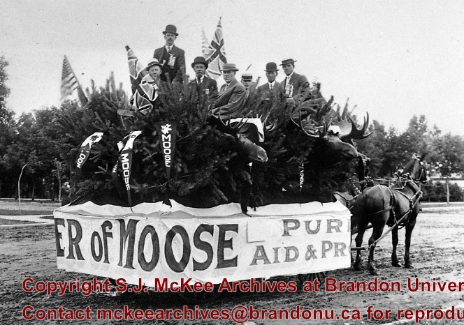
July 12 Orange Lodge parade in progress; Shows that there was a building in what was for many years, a small vacant lot behind the Bank of Montreal; Campbell & Campbell building and Security Block. Davidson (photography) Studio on awning - became Henfries studio and, in 1923, Jerrets' Studio.
Custodial History
For custodial history see the collection level description of the Lawrence Stuckey collection.
Scope and Content
100 Block of Tenth Street
Notes
Probably taken from Strathcona Block
Creator provided by Fred McGuinness collection (20-2009).


