The Medicine Hat Exhibition and Stampede Parade Day was held on Thursday, July 19, 1962, at 9:30 a.m. The local newspaper reported that approximately 24,000 people were in attendance to see parade marshall Rod Ashburner leading 175 entries consisting of 90 floats, 75 horses, and 10 bands. There were 19 parade categories eligible for $12,000 in prize money and included: junior and senior cowboys and cowgirls; fancy and Shetland ponies; sulky class open; comic, commercial, industrial and organizational floats; decorated cars; special ranch class; 4-H Clubs; and a non-competitive class.
The parade route started at Second St. and Allowance Ave., from Second St. to Ash Ave., north on Ash to First St. SE., from First St. S.E. to Fourth Ave., south to Second St. to South Railway St., south on South Railway St. to Third St., with a finish at McLeod Trail. A route map was published in the Medicine Hat News the day before the parade.
Aerial photographs of the parade were taken by Medicine Hat News photographer Howard Heid (1930-2005) from the private helicopter of John Bourn. Bourn was a pilot from Woodville, Wisconsin, who chartered his four-seater helicopter for sight-seers at exhibitions and stampedes across the county.
(Sources: Pat Currie, "Let 'Er Go!," Medicine Hat News, 19 July 1962,1; Harald Gunderson, "'Eye in the Sky' Best Parade View," Medicine Hat News, 19 July 1962,1; "Parade Starts at 9:30 Sharp," 18 July 1962)
Scope and Content
Photograph shows an aerial view of the Medicine Hat Exhibition and Stampede Parade route, with a focus on Second Street SE. Visible store signs include: Gardener's Used Cars, Provincial Treasury Branch, Furvey's Furniture and Appliances, J.J. Moore & Son Furniture, Alberta Credit Jewellers, James Richardson & Sons, Medicine Hat Gas Power Water City Owned Utilities.
Notes
This photograph shows the neighbourhood before rezoning and commercial development.
Building became the Oak Theatre ca. 1930. Reopened as Towne Cinema ca. 1980 after being closed for many years. [The Towne Cinema has now been closed for many years. P.E. 19/06/09]
Custodial History
For custodial history see the collection level description of the Lawrence Stuckey collection.
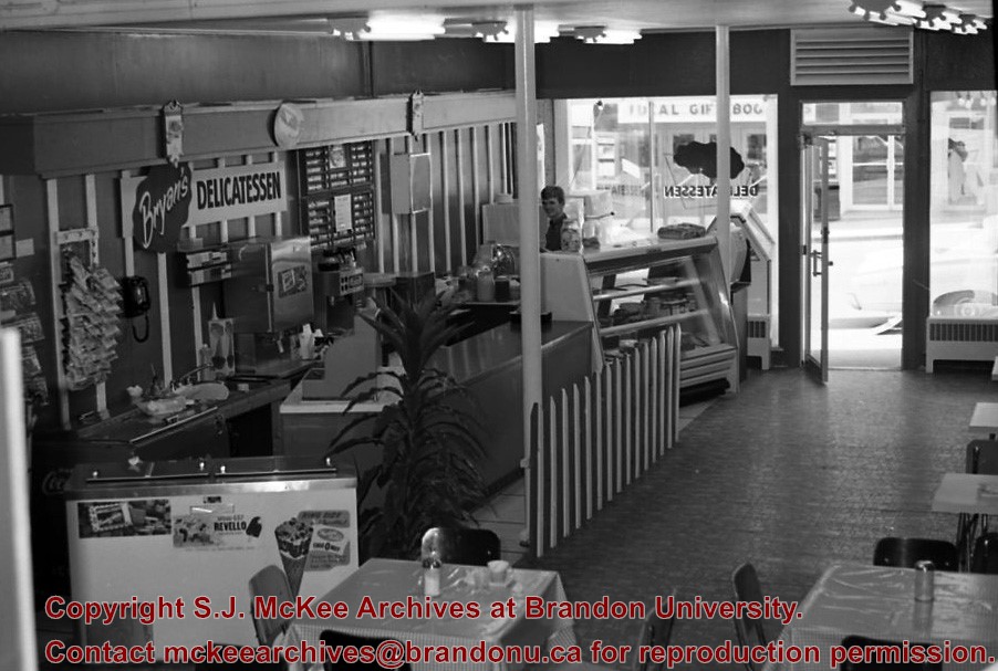
Scope and Content
Aagaard's Cafe dining area
Notes
Located at 29 8th Street
[Mr. Stuckey put two negatives in the same envelope, numbering them E9 and E9a. We have separated them.]
Building became the Oak Theatre ca. 1930. Reopened as Towne Cinema ca. 1980 after being closed for many years. [The Towne Cinema has now been closed for many years. P.E. 19/06/09]
Custodial History
For custodial history see the collection level description of the Lawrence Stuckey collection.
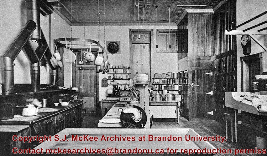
Scope and Content
Aagaard's Cafe main kitchen area
Notes
Located at 29 8th Street
[Mr. Stuckey put two negatives in the same envelope, numbering them E9 and E9a. We have separated them.]
The Medicine Hat Exhibition and Stampede Parade Day was held on Thursday, July 19, 1962, at 9:30 a.m. The local newspaper reported that approximately 24,000 people were in attendance to see parade marshall Rod Ashburner leading 175 entries consisting of 90 floats, 75 horses, and 10 bands. There were 19 parade categories eligible for $12,000 in prize money and included: junior and senior cowboys and cowgirls; fancy and Shetland ponies; sulky class open; comic, commercial, industrial and organizational floats; decorated cars; special ranch class; 4-H Clubs; and a non-competitive class.
The parade route started at Second St. and Allowance Ave., from Second St. to Ash Ave., north on Ash to First St. SE., from First St. S.E. to Fourth Ave., south to Second St. to South Railway St., south on South Railway St. to Third St., with a finish at McLeod Trail. A route map was published in the Medicine Hat News the day before the parade.
Aerial photographs of the parade were taken by Medicine Hat News photographer Howard Heid (1930-2005) from the private helicopter of John Bourn. Bourn was a pilot from Woodville, Wisconsin, who chartered his four-seater helicopter for sight-seers at exhibitions and stampedes across the county.
(Sources: Pat Currie, "Let 'Er Go!," Medicine Hat News, 19 July 1962,1; Harald Gunderson, "'Eye in the Sky' Best Parade View," Medicine Hat News, 19 July 1962,1; "Parade Starts at 9:30 Sharp," 18 July 1962)
Scope and Content
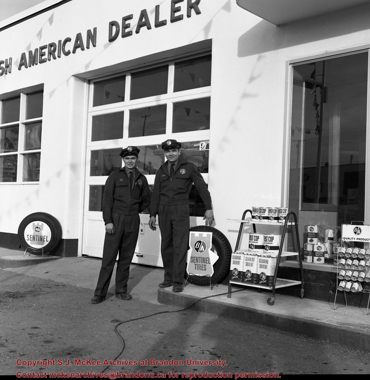
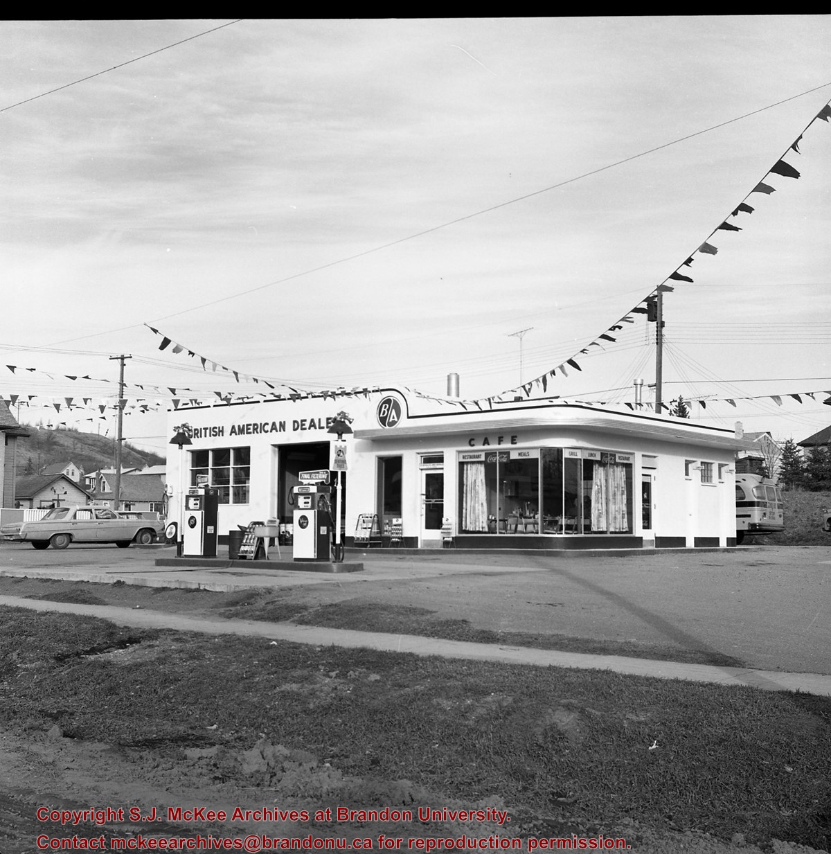
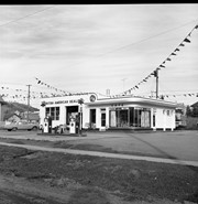
Photograph shows an aerial view of the Medicine Hat Exhibition and Stampede Parade route with a focus on the First Street SE. A number of gas stations and garages are visible along this route and include Texaco, Shell, Ford, and B/A. The Fraternal Order of Eagles lodge is also visible.
Notes
This photograph appeared on the front page of The Medicine Hat News (19 July 1962).
For custodial history see the collection level description of the Lawrence Stuckey collection.
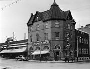
Scope and Content
This image shows various commercial buildings located on the east side of the 100 block of 10th Street.
Businesses shown include the Brandon Chamber of Commerce, Richardson Securities of Canada, Carlton Cafe, and Heming McCallum Jewellers
Notes
[Mr. Stuckey put three negatives and three prints in same envelope. We have separated them and numbered the negatives EA3(1), EA3(2) and EA3(3), and the prints EA3(1a), EA3(2a), EA3(3a).]
The Medicine Hat Exhibition and Stampede Parade Day was held on Thursday, July 19, 1962, at 9:30 a.m. The local newspaper reported that approximately 24,000 people were in attendance to see parade marshall Rod Ashburner leading 175 entries consisting of 90 floats, 75 horses, and 10 bands. There were 19 parade categories eligible for $12,000 in prize money and included: junior and senior cowboys and cowgirls; fancy and Shetland ponies; sulky class open; comic, commercial, industrial and organizational floats; decorated cars; special ranch class; 4-H Clubs; and a non-competitive class.
The parade route started at Second St. and Allowance Ave., from Second St. to Ash Ave., north on Ash to First St. SE., from First St. S.E. to Fourth Ave., south to Second St. to South Railway St., south on South Railway St. to Third St., with a finish at McLeod Trail. A route map was published in the Medicine Hat News the day before the parade.
Aerial photographs of the parade were taken by Medicine Hat News photographer Howard Heid (1930-2005) from the private helicopter of John Bourn. Bourn was a pilot from Woodville, Wisconsin, who chartered his four-seater helicopter for sight-seers at exhibitions and stampedes across the county.
(Sources: Pat Currie, "Let 'Er Go!," Medicine Hat News, 19 July 1962,1; Harald Gunderson, "'Eye in the Sky' Best Parade View," Medicine Hat News, 19 July 1962,1; "Parade Starts at 9:30 Sharp," 18 July 1962)
Scope and Content
Photograph shows an aerial view of the Medicine Hat Exhibition and Stampede Parade route with a focus on the First Street SE and and the South Railway Street merge. A number of gas stations and garages are visible along this route and include Texaco, Shell, Ford, and B/A. The Fraternal Order of Eagles lodge is also visible.
Notes
This photograph shows the neighbourhood before rezoning and commercial development.
For custodial history see the collection level description of the Lawrence Stuckey collection.
Scope and Content
This image shows various commercial buildings located on the east side of the 100 block of 10th Street.
Businesses shown include the Bank of Montreal, Barclay's Shoe Store, Carlton Cafe, and Ted Heming Jewellers
Notes
[Mr. Stuckey put three negatives and three prints in same envelope. We have separated them and numbered the negatives EA3(1), EA3(2) and EA3(3), and the prints EA3(1a), EA3(2a), EA3(3a).]
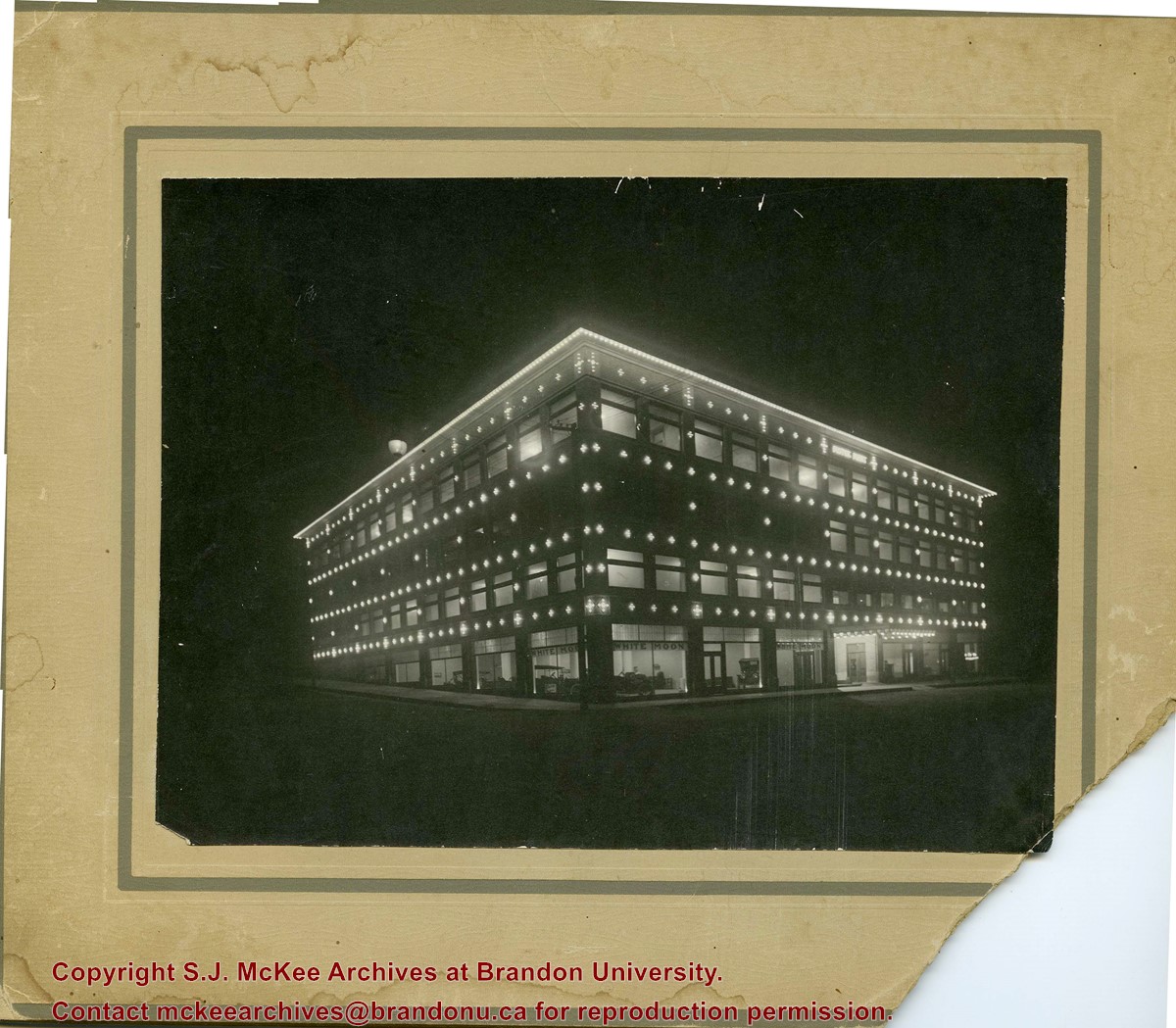
The Motor Mart Building in Sioux City, Iowa, is listed on the United States National Park Service's National Register of Historic Places. The State Historical Society of Iowa submitted the application in 1993. The building is an architectural example of the Commercial Style of the late 19th and early 20th Century American Movement designed by E.J. Henriques and C.F. Lytle Co. The building has a concrete foundation, brick walls, and a concrete roof. The Turner Mushroom System, a patented structural system involving a poured reinforced concrete framed, was used in the construction of the building. (Source: National Register of Historic Places Registration Form [online], focus.nps.gov/pdfhost/docs/NRHP/Text/93000330.pdf)
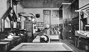
Scope and Content
Photograph shows a four-storey brick building, with a large showroom on the main floor. Inside, automobiles can be seen on display. Banners in the store windows read White Moon. The photograph was taken at night and exterior lights decorate the building.
Notes
Writing on the back of the photograph reads: Motor Mart, Sioux City, Ia., Lytle [?] Co. Archts., Mushroom Sys. truout.
See fonds level of the CKX records for custodial history.
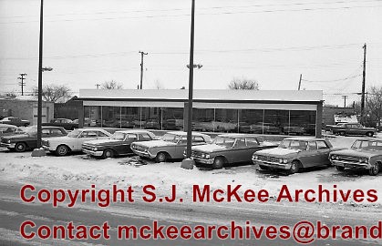
Scope and Content
Image of the southside of the 1100 block of Rosser Avenue in winter. Visible are O.L. Harwood Ltd., the Key Kafe and Northern Auto Parts. The Perth's building, located in the 1200 block, can be seen on the righthand side in the background. A number of vehicles, a pedestrian and a man shovelling snow are also visible.
Opened 1903. Closed 1923. Building became the Oak Theatre ca. 1930. Reopened as Towne Cinema ca. 1980 after being closed for many years. The building has since been demolished.
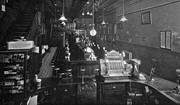
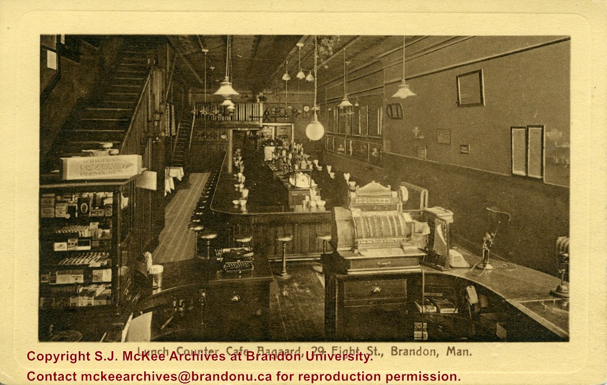
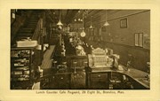
Scope and Content
Postcard shows the interior of the lunch counter and cashier register at Cafe Aagaard located at 29-8th Street Brandon.
Notes
Writing on the front of the postcard reads: Lunch Counter Cafe Aagaard, 29 Eigth St., Brandon, Man. The back of the postcard reads: Cafe Aagaard, Largest, Oldest and Best in Brandon. The postcard is addressed to Mrs. K.L. McGregor, 157-4th St.
See fonds level of the CKX records for custodial history.
Scope and Content
Image of the southside of the 1000 and 1100 block of Rosser Avenue looking east in winter. Visible in the foregraound are O.L. Harwood Ltd., and the Key Kafe. Buildings in the 1000 block include: the Imperial Bank of Canada, the original Post Office and Federal Building and the original Merchants Bank. A number of pedestrians are also visible, as are Christmas decorations on the streetlights and telephone poles.
The Brandon Daily Sun (26 May 1924, 16) reported the annual church parade of Brandon Lodge 173 Sons of England was held on Sunday, May 25, 1924. The Brandon City Band lead the parade with H.J. Barter, P.P., serving as parade marshal. Over 100 members paraded to St. Mary's Church. Representatives from a variety of lodges participated, including Alexander, Neepawa, Souris, Wawanesa, and Lodge Carpenter Juveniles.
Scope and Content
Photograph shows a parade travelling southwards on 10th Street between Rosser and Princess Avenues. A mounted rider wearing white appears to be leading the parade. A car draped with American and British flags follows. A band follows the vehicle. Individuals wearing white hats walk up the street.
Business visible on the west side (100-block) of 10th Street include: Doig, Rankin, & Robertson, Limited; Bowling Alley, Billiards; Olympia Cafe Candies. The second storey on the Hughes Building has not been erected. The Alexandra Block, Strathcona Block, Olympia Block are visible. A large Union Jack flys from the Canadian Pacific Station. Vehicles are diagonally parked on both sides of 10th Street.
Notes
Back of photograph is stamped: Hughes & Co. Ltd., 1009 Princess Ave., Brandon, Man. Date for photograph obtained from licence plates.


.jpg?width=1200&404=no-img.jpg&watermark=wmk)
.jpg?width=180&404=no-img.jpg)


.jpg?width=1200&404=no-img.jpg&watermark=wmk)
.jpg?width=180&404=no-img.jpg)
.jpg?width=1200&404=no-img.jpg&watermark=wmk)
.jpg?width=180&404=no-img.jpg)
.jpg?width=1200&404=no-img.jpg&watermark=wmk)
.jpg?width=180&404=no-img.jpg)


.jpg%3fmaxheight%3d1000%26maxwidth%3d1000%26watermark%3dwmk&description=10th+Street+Businesses+-+East+Side+of+100+Block)
.jpg%3fmaxheight%3d1000%26maxwidth%3d1000%26watermark%3dwmk&description=10th+Street+Businesses+-+East+Side+of+100+Block)
.jpg%3fmaxheight%3d1000%26maxwidth%3d1000%26watermark%3dwmk&description=10th+Street+Businesses+-+East+Side+of+100+Block)
.jpg%3fmaxheight%3d1000%26maxwidth%3d1000%26watermark%3dwmk&description=10th+Street+Businesses+-+East+Side+of+100+Block)
)
)
)