For custodial history see the collection level description of the Lawrence Stuckey collection.
Scope and Content
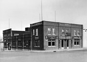
View of the southeast corner of Tenth Street and Princess Avenue, showing the Prince Edward Hotel (left) and an Imperial Oil Building (right).
Notes
The second floor of the Imperial Oil building became the Imperial Dance Garden in 1934. The small wooden post in a concrete foundation in the centre of the intersection was called a "Silent Policeman". You were supposed to keep it on your left while making a left turn. They took quite a beating.
[Information in "Notes" provided by the Fred McGuinness collection (20-2009).]
The Brandon Club (L. of center) was built in 1904. This local businessmen's club met in the old firehall until this building was erected by them.
[The Brandon Club closed and its assets were sold at auction on 18 June 2005. P.E. 01/06/2009]
Custodial History
For custodial history see the collection level description of the Lawrence Stuckey collection.
Scope and Content
Overhead view of Princess Avenue, west of 10th Street
Notes
Taken from roof of Prince Edward Hotel. Shows: Rat Portage Lumber Co., St. Matthew's Hall, Brandon Club, In distance Brandon College, International Harvester, Pumping Station. End of brick pavement at 14th Street is notable.
Corners of photograph mat are bent. Picture is cracked.
Scope and Content
Photograph shows an early view of Brandon's 6th Street in the 1880s. The Winter & O'Neail Groceries & Provisions and James Smart Hardware storefronts have been photographed. A street sign designating 6th Street can be seen below the Winter & O'Neail sign. A horse and cart is parked in front of the grocery store. A number of men wearing hats and jackets are standing along the boardwalk while posing for the picture. Lumber/timber saws are displayed in teh windows of the hardware store.
Notes
Front of photograph reads: 6th Street, Brandon, Manitoba, 1881-1882, Entrance [to Winter & O'Neail] corner of Rosser Ave & 6th Street.
Left hand corner of mat is bent. Mock-up instructions are written in pencil at the bottom right hand corner. Portions of the photograph itself are marked with pen.
History / Biographical
The Queen's Hotel was located on the corner of Rosser Avenue and Tenth Street (Steen & Boyce, 1882. Brandon, Manitoba, Canada and Her Industries. Steen & Boyce Publishers Printers & Binders, 81.). Therefore this photo appears to display Rosser Avenue looking east. P.E. 11/06/09
Scope and Content
Photograph shows early Rosser Avenue under construction between 9th Street and 10th Street in the 1880s. Buildings that line the avenue are wood framed and there are wooden boardwalks in front of a few structures. On the north side of Rosser Avenue signs for Fortier & Bucke Commision Agents and Transit House (Hotel) can be seen. On the south side of Rosser Avenue, the Queen's Hotel and Robinson Brothers and Company groceries and dry goods store are open for business. A family appears to be standing on the stoop at the dry goods store. A boy is lounging in the entryway of the Queen's Hotel. A man is standing on a wooden plank that extends across the dirt road of Rosser Avenue between the dry goods store and the commission agents' shop.
Photograph has pen markings and publishing mark-up notes on front and back of matting
Scope and Content
Photograph shows the north side of the 900-block of Rosser Avenue, facing west from 9th Street. All the shops appear to be woodframed buildings; the sidewalk has yet to be installed and wooden planks have been laid down in front of the shops. Visible storefronts include: (left to right): Leask & Rose, general merchants (at the 11th Street intersect); Fortier & Bucke - Manufacturers' Agents and CPR Express Co.; The New Era - real estate office; Imperial Bank of Canada; Durand & Macdonald Law Office, T.D. McLean - jeweller; Deacon & Hooper - grocers; and J. Barker Vosburgh - Surgeon & Dentist. The building in the foreground has Rosser Avenue and 9th Street street signs affixed above the entrance to the building. A chuckwagon is parked in front of Fortier & Bucke.
Notes
Writing on the front of the photograph reads: Brandon.
According to Russ Gourluck (Silver Screens on the Prairie, Winnipeg: Great Plains Publications, 2012, 26), the Orpheum Theatre was in operation from 1917 to 1920 when it then became the Willis Theatre.
Scope and Content
Postcard shows the 100 block of 10th Street facing north. The CPR train station can be seen at the end of 10th Street. The sign for the Rex Cafe is visible on the west side of 10th Street. On the east side of 10th Street, billboards for Campbell & Campbell furniture are visible as well as signs for Pianos and the Orpheum Theatre. Motorists and cyclists share the road. Street car tracks run the length of 10th Street.
Notes
Postcard was manufactured by T.B. [Tichnor Brothers, Inc., 1908-1987] Cambridge, Massachusetts.
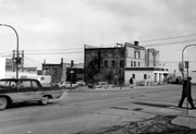
Photograph is looking east northeast from the southwest corner of the intersection. Visible are: Brandon Hotel, public parking lot and a service station.
Repro Restriction
The McKee Archives is the copyright holder for the Stuckey materials.
Photograph shows the Brandon Wheat Market along Pacific Avenue on November 30, 1885. Farmers can be seen driving wagon teams loaded with bags of grain in line on Pacific Avenue from 10 Street to at least 7th Street. On the north side of Pacific Avenue the CPR Land Office and grain elevators are pictured. On the south side of Pacific Avenue, the general merchant/hardware store Bower, Blackburn, Mundell & Porter is situated on the corner of Pacific Avenue and 10th Street. A 10th Street sign is affixed to the merchants' store. On the east side of the general store, Edie House, the Grand View Hotel, and a Farmers' boarding and lodging house can be seen. Most of the buildings appear to be woodframed except for the Grand View, which is constructed of brick. Sidewalks appear to be in place on the south side of Pacific and snow dusts the streets. A baby swathed in winter clothing sits in a pram/baby carriage in front of the general store.
Notes
Writing on the front of the photograph reads: Novemeber 30th, 1885, Brandon Wheat Market
Photograph is scratched and has been glued to a backing board that has warped over time
Scope and Content
Photograph shows street view of the northeast intersection of the 000 block of 8th Street and Rosser Avenue. Horse and buggies are parked along the east side of 8th Street. Businesses on the east side of 8th Street from Pacific to Rosser Avenues are clearly visible and include: a Lunch Room (likely Aagaard's Lunch Counter), the Hotel Imperial Annex, Liverpool House (a boarding house), R.S. Thompson and Company Real Estate Office (Land Office), a barber shop (likely J. Coulter's), Frank Gowen photography studio, and Fleming's Drug Store. A possible street fair is in progress on Rosser Avenue. One man is standing on a soap box and is surrounded by a crowd in the middle of 8th Street. Another man can be seen standing behind a booth on the northwest street corner. Building construction appears to be happening on the west corner of 8th Street and Rosser Avenue.
Notes
Writing on the front of the photograph matting reads: 297. One photograph (20-2009.80) is glued below the photograph. Another photograph is glued on the reverse side. Page appears to be from a photo album.
Photograph is scratched and has been glued to a backing board that has warped over time
Scope and Content
Photograph shows street view of intersection of the 000 block of 8th Street and Rosser Avenue. Horse and buggies are travelling on both roads. Businesses on the east side of 8th Street from Pacific to Rosser Avenues are clearly visible and include: a Lunch Room (likely Aagaard's Lunch Counter), the Hotel Imperial Annex, Liverpool House (a boarding house), R.S. Thompson and Company Real Estate Office (Land Office), a barber shop (likely J. Coulter's), Frank Gowen photography studio, and Fleming's Drug Store. A possible street fair is in progress on Rosser Avenue. One man is surrounded by a crowd adjacent to the Fleming Block, another man stands on a soap box in the middle of the intersection, while a third man is standing behind a booth. Building construction appears to be happening on the west corner of 7th Street and Rosser Avenue.
Notes
Writing on the front of the photograph matting reads: 296. One photograph (20-2009.12) is glued above and two others are glued on the reverse side. Page appears to be from a photo album.
For custodial history see the collection level description of the Lawrence Stuckey collection.
Scope and Content
Northwest corner of Tenth Street and Rosser Avenue
Notes
Showing (left to right): Fraser Building 1890, John E. Smith Block 1907, The Canadian Bank of Commerce 1907, Cecil Hotel 1910, Brandon Sun Building 1905; Can be dated by Cecil Hotel (built 1910) and because the streets were paved and streetcar tracks laid in 1912.
Postcard shows a street scene of Donald Street looking south from the Portage Avenue Intersection.
Notes
Writing on the back of the postcard reads: Aug 9, Dear ruth, Aunt Eva, Aunt Annie and Fred were over to the bowlnig greens tonight. Every one fine. Doddy. Postcard is addressed to Ruth McGuinness, 337-17th St., Brandon, Man. Postmarked: Winnipeg 12 PM Aug 10 1927 Man.
[The land on which city hall stood in this photo is now known as Princess Park. P.E. 01/06/09]
Custodial History
For custodial history see the collection level description of the Lawrence Stuckey collection.
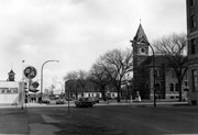
Scope and Content
Princess Avenue, showing City Hall & CKX radio tower
Notes
[View is from 9th Street looking east. P.E.]
"Radio towers of CKX on city hall grounds were 150 feet tall; Studio and transmitter were on the east side of city hall." - Fred McGuinness collection (20-2009).


.jpg?width=1200&404=no-img.jpg&watermark=wmk)
.jpg?width=180&404=no-img.jpg)


.jpg%3fmaxheight%3d1000%26maxwidth%3d1000%26watermark%3dwmk&description=Princess+Avenue+east+of+Tenth+Street)