Skip header and navigation

Revise Search

20 records – page 1 of 1.

Part Of
CKX fonds
Description Level
Item
GMD
graphic
Date Range
after 1954
Accession Number
11-2010
Part Of
CKX fonds
Creator
CKX
Description Level
Item
Series Number
S
Item Number
11-2010.S116j
Accession Number
11-2010
GMD
graphic
Date Range
after 1954
Physical Description
5" x 4" (b/w)
Material Details
Negative
Custodial History
See fonds level of the CKX records for custodial history.
Scope and Content
Image of people swimming in the Assiniboine River.
Name Access
CKX
Assiniboine River
Subject Access
Rivers
building exteriors
persons
swimming
cars
Storage Location
CKX fonds - 2010 accessions
Images
Show Less

Curries Landing (Assiniboine River)

http://archives.brandonu.ca/en/permalink/descriptions11132
Part Of
RG 11 Lawrence Stuckey fonds
Description Level
Item
GMD
graphic
Date Range
Apr. 12, 1977
Part Of
RG 11 Lawrence Stuckey fonds
Creator
L.A. Stuckey
Description Level
Item
Series Number
3.3
Item Number
1-2002.3.3.BSE[366a]
GMD
graphic
Date Range
Apr. 12, 1977
Physical Description
2.5" x 2.5"
Material Details
Negative
Custodial History
For custodial history see the collection level description of the Lawrence Stuckey collection.
Scope and Content
Image of Curries Landing (Assiniboine River).
Notes
[Brandon SE includes communities south of Trans-Canada #1 highway and east of PTH #10.]
Name Access
Curries Landing
Assiniboine River
Subject Access
Rivers
Storage Location
Lawrence Stuckey collection
Arrangement
[Mr. Stuckey put three negatives in the same envelope. We have separated them and numbered the negatives (366a) to(366c)].
Images
Show Less

Curries Landing (Assiniboine River)

http://archives.brandonu.ca/en/permalink/descriptions11134
Part Of
RG 11 Lawrence Stuckey fonds
Description Level
Item
GMD
graphic
Date Range
Apr. 12, 1977
Part Of
RG 11 Lawrence Stuckey fonds
Creator
L.A. Stuckey
Description Level
Item
Series Number
3.3
Item Number
1-2002.3.3.BSE[366b]
GMD
graphic
Date Range
Apr. 12, 1977
Physical Description
2.5" x 2.5"
Material Details
Negative
Custodial History
For custodial history see the collection level description of the Lawrence Stuckey collection.
Scope and Content
Image of Curries Landing (Assiniboine River).
Notes
[Brandon SE includes communities south of Trans-Canada #1 highway and east of PTH #10.]
Name Access
Curries Landing
Assiniboine River
Subject Access
Rivers
Storage Location
Lawrence Stuckey collection
Arrangement
[Mr. Stuckey put three negatives in the same envelope. We have separated them and numbered the negatives (366a) to(366c)].
Images
Show Less

Curries Landing (Assiniboine River)

http://archives.brandonu.ca/en/permalink/descriptions11135
Part Of
RG 11 Lawrence Stuckey fonds
Description Level
Item
GMD
graphic
Date Range
Apr. 12, 1977
Part Of
RG 11 Lawrence Stuckey fonds
Creator
L.A. Stuckey
Description Level
Item
Series Number
3.3
Item Number
1-2002.3.3.BSE[366c]
GMD
graphic
Date Range
Apr. 12, 1977
Physical Description
2.5" x 2.5"
Material Details
Negative
Custodial History
For custodial history see the collection level description of the Lawrence Stuckey collection.
Scope and Content
Image of Curries Landing (Assiniboine River).
Notes
[Brandon SE includes communities south of Trans-Canada #1 highway and east of PTH #10.]
Name Access
Curries Landing
Assiniboine River
Subject Access
Rivers
Storage Location
Lawrence Stuckey collection
Arrangement
[Mr. Stuckey put three negatives in the same envelope. We have separated them and numbered the negatives (366a) to(366c)].
Images
Show Less

Morning reflection of Brandon's skyline on the Assiniboine River

http://archives.brandonu.ca/en/permalink/descriptions13781
Part Of
Fred McGuinness collection
Description Level
Item
GMD
graphic
Date Range
[1980s]
Accession Number
20-2009
Part Of
Fred McGuinness collection
Creator
Photographer: Sandy Black
Description Level
Item
Series Number
McG 9
Item Number
20-2009.92
Accession Number
20-2009
GMD
graphic
Date Range
[1980s]
Physical Description
5.5" x 3.5" (colour)
Material Details
postcard
Scope and Content
Postcard shows the 100 block of 10th Street facing north. The CPR train station can be seen at the end of 10th Street. The sign for the Rex Cafe is visible on the west side of 10th Street. On the east side of 10th Street, billboards for Campbell & Campbell furniture are visible as well as signs for Pianos and the Orpheum Theatre. Motorists and cyclists share the road. Street car tracks run the length of 10th Street.
Notes
Back of postcard reads: Morning reflection of Brandon's skyline on the Assiniboine River, photo by Sandy Black, printed in Brandno, Manitoba, Canada by Leech Printing Ltd.
Name Access
Assiniboine River
McKenzie Seeds
Scotia Towers
Subject Access
Rivers
downtown
Storage Location
RG 5 photograph storage drawer 2 (hanging photos)
Images
Show Less

100-block 10th Street, facing west (3)

http://archives.brandonu.ca/en/permalink/descriptions8408
Part Of
Joseph H. Hughes collection
Description Level
Item
GMD
graphic
Date Range
c. 1955
Accession Number
3-1997
Part Of
Joseph H. Hughes collection
Creator
Photographer: R.M. Coleman
Description Level
Item
Series Number
3-1997.1
Item Number
3-1997.1.30
Accession Number
3-1997
GMD
graphic
Date Range
c. 1955
Physical Description
8 " x 5" (b/w)
Physical Condition
good
Scope and Content
Photograph shows the west side of 10th Street between Rosser and Princess Avenues in the winter. Visible businesses include: Bottomley's, Simpsons-Sears, Lionel Electric, Allied Hardware Stores, Box Brothers Hardware, Doig's. Painted on the north face of the Strathcona Block are two advertisements, one for Sutherland and Robertson [Grocery] and the other for Boyd Electric Co. Ltd.
Name Access
10th Street
Bottomley's
Simpsons-Sears Ltd.
Lionel Electric
Sutherland and Robertson
Boyd Electric Co. Ltd.
Strathcona Block
Box Brothers Hardware
Doig's
Allied Hardware
Alexandra Block
Subject Access
downtowns
street scenes
Brandon business buildings & facilities after 1940
building exteriors
winter
Storage Location
RG 5 photograph storage drawer
Images
Show Less

Lawrence Stuckey slide collection

http://archives.brandonu.ca/en/permalink/descriptions9512
Part Of
RG 11 Lawrence Stuckey fonds
Description Level
Series
GMD
graphic
Date Range
1954-1982
Accession Number
1-2002
Part Of
RG 11 Lawrence Stuckey fonds
Description Level
Series
Series Number
2
Accession Number
1-2002
GMD
graphic
Date Range
1954-1982
Physical Description
approximately 3838 colour slides
History / Biographical
For history/bio information see the collection level description of the Lawrence Stuckey collection.
Custodial History
For custodial history see the collection level description of the Lawrence Stuckey collection.
Scope and Content
Series consists of slides created from photographs taken by Lawrence Stuckey during his travels throughout Manitoba, other parts of Canada and the United States. Although Lawrence and his wife Mavis travelled for pleasure, their destinations were often chosen deliberately to enable Lawrence to explore and photograph specific landscapes, flora and fauna.
Name Access
Glendenning
Assiniboine River
Souris River
Sidney
Manitoba
Whiteshell
Carberry Hills
Baldhead Hills
Sprucewoods
Duck Mountains
Rossburn
Thompson
Kelsey Trail
E.T. Seton Park
Steeprock Bay
Steeprock River
Flin Flon
Rocky Lake
Lake Winnipegosis
Turtle Mountains
Riding Mountain National Park
Moon Lake
Lake Katherine
Clear Lake
Arrowhead Trail
B&B Trail
Ominik Trail
Gorge Creek
Scarborough
Ontario
Edwards Gardens
Royal Botanical Gardens
Prince Albert
Saskatoon
Lake Madge
Winnipeg
Saskatchewan
International Peace Gardens
South Dakota
Black Hills
North Dakota
Quebec
Kenora
Qu'Appelle Valley
Theodore Roosevelt National Monument
Toronto
Point Pelee
Port Dover
Windsor
Yellowstone National Park
Wyoming
Ottawa
Scotsbluff
Nebraska
Mt. Evans Road
Colorado
Berthoud Pass
Milner Pass
Dinosaur Park
Trail Ridge
Rollins Pass
Grand Teton
Beartooth Pass
Craters of the Moon
Idaho
Medicine Bow National Fort
Michigan
Wisconsin
Quebec City
Mont. Tremblant Park
Sugar Camp
Satine-Anne-de-Bellevue Canal
Montreal
Banff National Park
Larch Valley
Sentinel Pass
Lake Louise
Moraine Lake
Athabaska River
Plain of Six
Columbia Icefields
Bow River
Victoria Glacier
Yoho Pass
Yoho National Park
Wapta Falls
Hoodoo Park
Waterfall Valley
Highline Trail
Burgess Pass
Takakaw Falls
Kicking Horse
Skyline Trail
Waterton Lakes National Park
Emerald Lake
Yoho Valley
Twin Falls Creek
Trans Canada Highway
Subject Access
geographic features
manmade geographic features
natural geographic features
political geographic features
natural phenomena
natural waterways
bridges
canals
mines
roads
trails
monuments
historical markers
lakes
mountains
national parks
parks
hills
valleys
Rivers
cities
towns
landscapes
creeks
gardens
Plants
trees
badlands
glaciers
icefields
hoodoos
waterfalls
beaches
forests
Accruals
Additional slides of flora and fauna taken by Stuckey during his travels are housed in the McKee Archives. Those slides are unprocessed at present.
Repro Restriction
The McKee Archives is the copyright holder for the Stuckey materials.
Storage Location
Lawrence Stuckey collection
Show Less

Stockton Ferry, Stockton, Manitoba

http://archives.brandonu.ca/en/permalink/descriptions11022
Part Of
RG 11 Lawrence Stuckey fonds
Description Level
Item
GMD
graphic
Date Range
May 23, 1981
Part Of
RG 11 Lawrence Stuckey fonds
Creator
L.A. Stuckey
Description Level
Item
Series Number
3.3
Item Number
1-2002.3.3.BSE[361]
GMD
graphic
Date Range
May 23, 1981
Physical Description
2.5" x 2.5"
Material Details
Negative
Custodial History
For custodial history see the collection level description of the Lawrence Stuckey collection.
Notes
[Brandon SE includes communities south of Trans-Canada #1 highway and east of PTH #10.]
Name Access
Assiniboine River
Stockton, Manitoba
Stockton Ferry
Subject Access
ferries
Transportation
water transportation
ferry services
Rivers
Storage Location
Lawrence Stuckey collection
Images
Show Less

Assiniboine River; Treesbank Ferry - Stockton Ferry

http://archives.brandonu.ca/en/permalink/descriptions11023
Part Of
RG 11 Lawrence Stuckey fonds
Description Level
Item
GMD
graphic
Date Range
May 23, 1981
Part Of
RG 11 Lawrence Stuckey fonds
Creator
L.A. Stuckey
Description Level
Item
Series Number
3.3
Item Number
1-2002.3.3.BSE[362a]
GMD
graphic
Date Range
May 23, 1981
Physical Description
2.5" x 2.5"
Material Details
Negative
History / Biographical
Mr. Stuckey's notes: Jacques Wendover and Errol Bredin.
Custodial History
For custodial history see the collection level description of the Lawrence Stuckey collection.
Scope and Content
Image of Assiniboine River; Treesbank Ferry - Stockton Ferry.
Notes
[Brandon SE includes communities south of Trans-Canada #1 highway and east of PTH #10.]
Name Access
Assiniboine River
Stockton, Manitoba
Stockton Ferry
Treesbank Ferry
Jacques Wendover
Errol Bredin
Subject Access
ferries
Transportation
water transportation
ferry services
Rivers
Storage Location
Lawrence Stuckey collection
Arrangement
[Mr. Stuckey put four negatives in the same envelope. We have separated them and numbered the negatives (362a) to (362d)].
Images
Show Less

Assiniboine River; Treesbank Ferry - Stockton Ferry

http://archives.brandonu.ca/en/permalink/descriptions11024
Part Of
RG 11 Lawrence Stuckey fonds
Description Level
Item
GMD
graphic
Date Range
May 23, 1981
Part Of
RG 11 Lawrence Stuckey fonds
Creator
L.A. Stuckey
Description Level
Item
Series Number
3.3
Item Number
1-2002.3.3.BSE[362b]
GMD
graphic
Date Range
May 23, 1981
Physical Description
2.5" x 2.5"
Material Details
Negative
History / Biographical
Mr. Stuckey's notes: Jacques Wendover and Errol Bredin.
Custodial History
For custodial history see the collection level description of the Lawrence Stuckey collection.
Scope and Content
Image of Assiniboine River; Treesbank Ferry - Stockton Ferry.
Notes
[Brandon SE includes communities south of Trans-Canada #1 highway and east of PTH #10.]
Name Access
Assiniboine River
Stockton, Manitoba
Stockton Ferry
Treesbank Ferry
Jacques Wendover
Errol Bredin
Subject Access
ferries
Transportation
water transportation
ferry services
Rivers
Storage Location
Lawrence Stuckey collection
Arrangement
[Mr. Stuckey put four negatives in the same envelope. We have separated them and numbered the negatives (362a) to (362d)].
Images
Show Less

Assiniboine River; Treesbank Ferry - Stockton Ferry

http://archives.brandonu.ca/en/permalink/descriptions11025
Part Of
RG 11 Lawrence Stuckey fonds
Description Level
Item
GMD
graphic
Date Range
May 23, 1981
Part Of
RG 11 Lawrence Stuckey fonds
Creator
L.A. Stuckey
Description Level
Item
Series Number
3.3
Item Number
1-2002.3.3.BSE[362c]
GMD
graphic
Date Range
May 23, 1981
Physical Description
2.5" x 2.5"
Material Details
Negative
History / Biographical
Mr. Stuckey's notes: Jacques Wendover and Errol Bredin.
Custodial History
For custodial history see the collection level description of the Lawrence Stuckey collection.
Scope and Content
Image of Assiniboine River; Treesbank Ferry - Stockton Ferry.
Notes
[Brandon SE includes communities south of Trans-Canada #1 highway and east of PTH #10.]
Name Access
Assiniboine River
Stockton, Manitoba
Stockton Ferry
Treesbank Ferry
Jacques Wendover
Errol Bredin
Subject Access
ferries
Transportation
water transportation
ferry services
Rivers
Storage Location
Lawrence Stuckey collection
Arrangement
[Mr. Stuckey put four negatives in the same envelope. We have separated them and numbered the negatives (362a) to (362d)].
Images
Show Less

Assiniboine River; Treesbank Ferry - Stockton Ferry

http://archives.brandonu.ca/en/permalink/descriptions11026
Part Of
RG 11 Lawrence Stuckey fonds
Description Level
Item
GMD
graphic
Date Range
May 23, 1981
Part Of
RG 11 Lawrence Stuckey fonds
Creator
L.A. Stuckey
Description Level
Item
Series Number
3.3
Item Number
1-2002.3.3.BSE[362d]
GMD
graphic
Date Range
May 23, 1981
Physical Description
2.5" x 2.5"
Material Details
Negative
History / Biographical
Mr. Stuckey's notes: Jacques Wendover and Errol Bredin.
Custodial History
For custodial history see the collection level description of the Lawrence Stuckey collection.
Scope and Content
Image of Assiniboine River; Treesbank Ferry - Stockton Ferry.
Notes
[Brandon SE includes communities south of Trans-Canada #1 highway and east of PTH #10.]
Name Access
Assiniboine River
Stockton, Manitoba
Stockton Ferry
Treesbank Ferry
Jacques Wendover
Errol Bredin
Subject Access
ferries
Transportation
water transportation
ferry services
Rivers
Storage Location
Lawrence Stuckey collection
Arrangement
[Mr. Stuckey put four negatives in the same envelope. We have separated them and numbered the negatives (362a) to (362d)].
Images
Show Less

West side of 10th Street facing north from Princess Avenue, Brandon, Manitoba

http://archives.brandonu.ca/en/permalink/descriptions8385
Part Of
Joseph H. Hughes collection
Description Level
Item
GMD
graphic
Date Range
c. 1959
Accession Number
3-1997
Part Of
Joseph H. Hughes collection
Description Level
Item
Series Number
3-1997.1
Item Number
3-1997.1.13
Accession Number
3-1997
GMD
graphic
Date Range
c. 1959
Physical Description
8" x 10" (b/w)
Physical Condition
good
History / Biographical
Doig's, originally located on Rosser Avenue, moved to the 10th Street location in 1921.
Scope and Content
Photograph of west side of 10th Street, Brandon, Manitoba, facing northwest. Visible businesses in the Alexander Block include Doig's, Box Brothers Hardware and Allied Hardware Stores, followed by Simpsons-Sears and Barry Neill Men's Wear in the Strathcona Block. The Johnny Smith Block is visible in the background.
Name Access
Strathcona Block
Alexandra Block
Doig's
Box Brothers Hardware
Simpsons-Sears Ltd.
Barry Neill Men's Wear
10th Street
Subject Access
downtowns
street scenes
Brandon business buildings & facilities after 1940
building exteriors
Storage Location
RG 5 photograph storage drawer
Images
Show Less

West side of 10th Street from Princess Avenue, Brandon, Manitoba

http://archives.brandonu.ca/en/permalink/descriptions8401
Part Of
Joseph H. Hughes collection
Description Level
Item
GMD
graphic
Date Range
c. 1955
Accession Number
3-1997
Part Of
Joseph H. Hughes collection
Description Level
Item
Series Number
3-1997.1
Item Number
3-1997.1.23
Accession Number
3-1997
GMD
graphic
Date Range
c. 1955
Physical Description
8" x 10" (b/w)
Physical Condition
good
Scope and Content
Photograph of west side of 10th Street, Brandon, Manitoba, facing northwest. Visible businesses in the Alexandra Block include Doig's, Box Brothers Hardware and Allied Hardware Stores, followed by Simpsons-Sears and Barry Neill Men's Wear in the Strathcona Block. The Johnny Smith Block is visible in the background.
Name Access
Strathcona Block
Alexandra Block
Doig's
Box Brothers Hardware
Simpsons-Sears Ltd.
Barry Neill Men's Wear
10th Street
Subject Access
downtowns
street scenes
Brandon business buildings & facilities after 1940
building exteriors
Storage Location
RG 5 photograph storage drawer
Images
Show Less

100-block 10th Street, facing southwest (2)

http://archives.brandonu.ca/en/permalink/descriptions8407
Part Of
Joseph H. Hughes collection
Description Level
Item
GMD
graphic
Date Range
c. 1950
Accession Number
3-1997
Part Of
Joseph H. Hughes collection
Description Level
Item
Series Number
3-1997.1
Item Number
3-1997.1.29
Accession Number
3-1997
GMD
graphic
Date Range
c. 1950
Physical Description
8 " x 10" (b/w)
Physical Condition
good
Scope and Content
Photograph shows the west side of 10th Street between Rosser and Princess Avenues. Visible businesses include: Recreation Bowling & Billiards, Bottomley's, Barry Neill Men's Wear, Simpsons-Sears, Allied Hardware Stores, Box Brothers Hardware, Doig's. Painted on the north face of the Strathcona Block are two advertisements, one for Sutherland and Robertson [Grocery] and the other for Boyd Electric Co. Ltd.
Name Access
10th Street
Recreation Bowling and Billiards
Bottomley's
Barry Neill Men's Wear
Simpsons-Sears Ltd.
Sutherland and Robertson
Boyd Electric Co. Ltd.
Strathcona Block
Box Brothers Hardware
Doig's
Allied Hardware
Alexandra Block
Subject Access
downtowns
street scenes
Brandon business buildings & facilities after 1940
building exteriors
Storage Location
RG 5 photograph storage drawer
Images
Show Less

Corner of 10th Street and Princess Avenue, Brandon, Manitoba

http://archives.brandonu.ca/en/permalink/descriptions8387
Part Of
Joseph H. Hughes collection
Description Level
Item
GMD
graphic
Date Range
c. 1930
Accession Number
3-1997
Part Of
Joseph H. Hughes collection
Description Level
Item
Series Number
3-1997.1
Item Number
3-1997.1.14
Accession Number
3-1997
GMD
graphic
Date Range
c. 1930
Physical Description
8 " x 10" (b/w)
Physical Condition
good
Scope and Content
Photograph shows the intersection of 10th Street and Princess Avenue, Brandon, Manitoba. View is facing northwest along west side of the 100-block of 10th Street. A stationary policeman/divider is at the centre of the intersection. Visible businesses include: Doig's, Plaza Shoe Shop, and Cambridge Clothes Shop. A horse-drawn sled is parked in front of Doig's store. The Olympia Block, Cecil Hotel, and CPR Station are visible in the background.
Name Access
Doig's
Plaza Shoe Shop
Cambridge Clothes Shop
Alexandra Block
Strathcona Block
10th Street
Princess Avenue
Subject Access
downtowns
street scenes
Brandon business buildings & facilities before 1940
building exteriors
Transportation
Storage Location
RG 5 photograph storage drawer
Images
Show Less

Hughes Building, Brandon, Manitoba

http://archives.brandonu.ca/en/permalink/descriptions8403
Part Of
Joseph H. Hughes collection
Description Level
Item
GMD
graphic
Date Range
c. 1955
Accession Number
3-1997
Part Of
Joseph H. Hughes collection
Description Level
Item
Series Number
3-1997.1
Item Number
3-1997.1.25
Accession Number
3-1997
GMD
graphic
Date Range
c. 1955
Physical Description
4.5" x 6.75" (b/w)
Physical Condition
good
Scope and Content
Photograph shows the northwest corner of 10th Street and Princess Avenue. Traffic on the west side of Princess Avenue appears to travelling both ways. A taxi waits at the intersection. Above the west entrance on the corner building is an electric sign that spells "Hughes Bldg." A second storey has been added to the portion of the Doig's shop that is adjacent to the Alexandra Block.
Notes
A negative accompanies the photograph.
Name Access
Doig's
Hughes Building
Alexandra Block
Princess Avenue
10th Street
Subject Access
downtowns
street scenes
Brandon business buildings & facilities after 1940
building exteriors
taxi
Storage Location
RG 5 photograph storage drawer
Images
Show Less

Hughes Building, corner of 10th Street and Princess Avenue, Brandon, Manitoba

http://archives.brandonu.ca/en/permalink/descriptions8404
Part Of
Joseph H. Hughes collection
Description Level
Item
GMD
graphic
Date Range
c. 1950
Accession Number
3-1997
Part Of
Joseph H. Hughes collection
Description Level
Item
Series Number
3-1997.1
Item Number
3-1997.1.26
Accession Number
3-1997
GMD
graphic
Date Range
c. 1950
Physical Description
4.5" x 6.75" (b/w)
Physical Condition
good
Scope and Content
Photograph shows the northwest corner of 10th Street and Princess Avenue. Traffic on the west side of Princess Avenue appears to travelling both ways. A car waits at the intersection. Above the west entrance on the corner building is an electric sign that spells "Hughes Bldg." A second storey has yet to be added to the portion of the Doig's shop that is adjacent to the Alexandra Block. Fitwell Tailors, a barber shop, and the Federal Building are visible on Princess Avenue.
Notes
A negative is contained in the same enclosure with the print.
Name Access
Doig's
Hughes Building
Alexandra Block
Princess Avenue
Fitwell Tailors
10th Street
Subject Access
downtowns
street scenes
Brandon business buildings & facilities after 1940
building exteriors
barbers
Storage Location
RG 5 photograph storage drawer
Images
Show Less

10th Street from Princess Avenue facing north, Brandon, Manitoba

http://archives.brandonu.ca/en/permalink/descriptions8402
Part Of
Joseph H. Hughes collection
Description Level
Item
GMD
graphic
Date Range
c. 1955
Accession Number
3-1997
Part Of
Joseph H. Hughes collection
Creator
Photographer: Jerrett Photo
Description Level
Item
Series Number
3-1997.1
Item Number
3-1997.1.24
Accession Number
3-1997
GMD
graphic
Date Range
c. 1955
Physical Description
3.5" x 5.5" (b/w)
Material Details
postcard
Physical Condition
good
Scope and Content
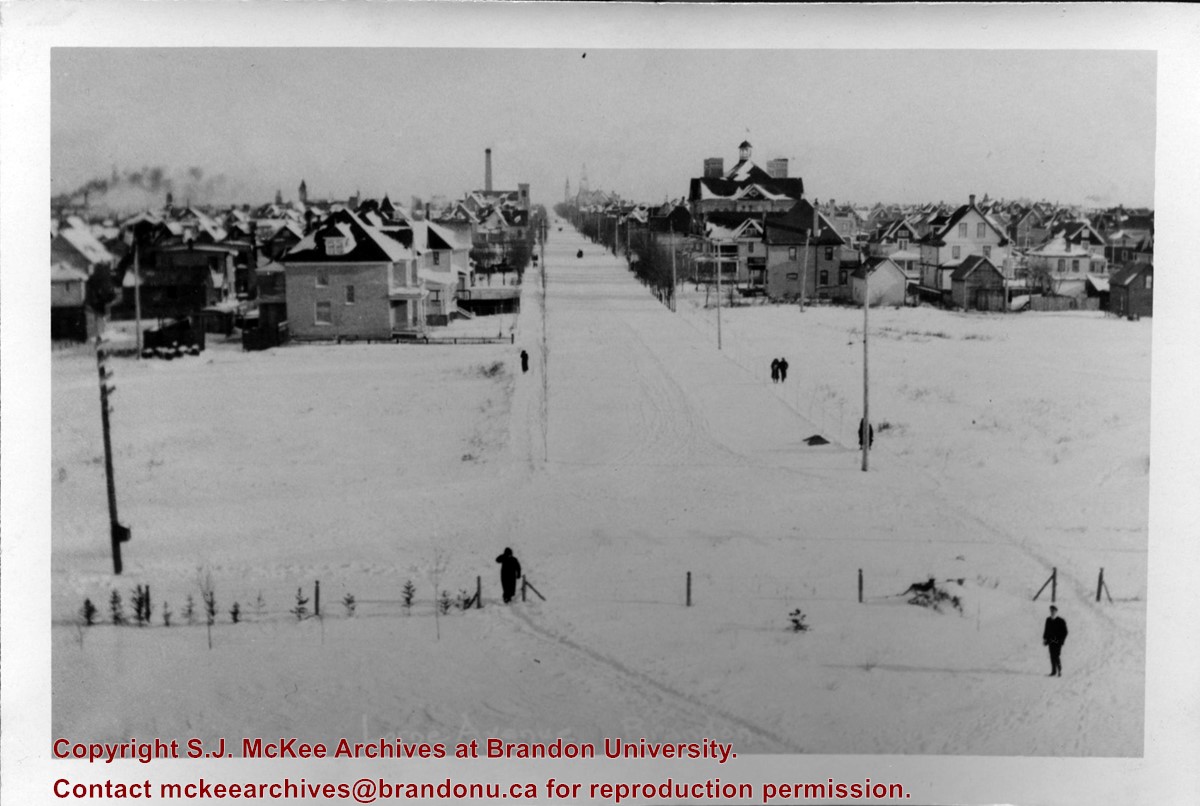
Photograph of 10th Street facing north from Princess Avenue. Vehicles are parallel parked on both sides of the street. The Welcome Brandon sign can be seen at the Rosser Avenue intersection. Visible businesses on the west side of 10th Street include: Doig's, Box Brothers Hardware and Allied Hardware Stores in the Alexandra Block; followed by Simpsons-Sears in the Strathcona Block. Barry Neill Men's Wear, Kresge's and the Cecil Hotel are also visible. The Johnny Smith Block is visible in the background. Visible businesses on the east side of 10th Street include: Ollies Steaks and Chops, Elna Sewing Centre, Carlton Cafe, Chop Suey. At the base of the hill the Canadian Pacific train station is visible at the base of the hill.
Notes
Writing on the front of the postcard reads: Tenth St. Brandon, Man.
Name Access
Strathcona Block
Alexandra Block
Doig's
Box Brothers Hardware
Simpsons-Sears Ltd.
Barry Neill Men's Wear
Kresge
Cecil Hotel
CPR Station
Ollies
Elna Sewing Centre
Carlton Cafe
10th Street
Subject Access
downtowns
street scenes
Brandon business buildings & facilities after 1940
building exteriors
Chinese restaurants
Storage Location
RG 5 photograph storage drawer
Images
Show Less

Lorne Avenue in winter

http://archives.brandonu.ca/en/permalink/descriptions10114
Part Of
RG 12 Brandon and Area Photograph Collection
Description Level
Item
GMD
graphic
Date Range
c. 1905
Part Of
RG 12 Brandon and Area Photograph Collection
Description Level
Item
Series Number
2
Item Number
BAPC 2.1
GMD
graphic
Date Range
c. 1905
Physical Description
4" x 6" (b/w)
Scope and Content
Photograph is looking east down Lorne Avenue from Brandon College.
Name Access
Lorne Avenue
18th Street
Park School
Subject Access
cityscapes
winter
Storage Location
BAPC photograph drawer
Images
Show Less

20 records – page 1 of 1.