Skip header and navigation

Revise Search

20 records – page 1 of 1.

Margaret Menzies collection

http://archives.brandonu.ca/en/permalink/descriptions12723
Part Of
MG 4 Brandon University Students
Description Level
Collection
GMD
multiple media
Date Range
1959-2007; predominant 1983-2001
Accession Number
13-2012
Part Of
MG 4 Brandon University Students
Description Level
Collection
Accession Number
13-2012
GMD
multiple media
Date Range
1959-2007; predominant 1983-2001
Physical Description
18 cm textual records
1 photograph
History / Biographical
Margaret Menzies was born on July 30th, 1920, at a family farm located in Oakburn, Manitoba. She grew up on the family farm and attended school in both Oakburn and Shoal Lake. She married Donald Menzies on June 4th, 1941. Together they had four children. In 1959, the family moved to Brandon, Manitoba, where they lived for the rest of their lives. Margaret Menzies was a longtime and active member of the International Toastmistress Club (ITC), and was also involved in the Consumers Association of Canada, Seniors for Seniors, as well as being a member of the Liberal Party of Canada and the Central United Church. Menzies did not graduate from high school in her early years, but managed to continue her education and receive a bachelor of arts degree from Brandon University at the age of 70. Margaret Menzies passed away on June 9th, 2012.
Custodial History
Records in the collection were brought to the S.J McKee Archives on July 13, 2012, by Gerald Brown, on behalf of the family of Margaret Menzies.
Scope and Content
Collection contains of two scrapbooks created by Margaret Menzies. The scrapbooks contain various cards, itinerary's, and other documents associated with Menzies' membership in the International Toastmistress Club. The items in the scrapbooks date from the mid 1980's to the late 1990's. Also included in the collection are four local history books. The first is a 100 year history of the town of Oakburn, Manitoba, from 1870 to 1970, published during celebrations of Manitoba's centenniary in 1970. Next is a book about the history of the town of Shoal Lake, Manitoba, which was published in 1959 on the 50th anniversary of the founding of the town of Shoal Lake in 1909. The last two books are the first and second volumes of Ripples on the Lake, which cover the history of the Shoal Lake municipality from 1884. The first volume covers the first 100 years of the history of the Shoal Lake region, being published in 1984. The second volume was published in 2007, covering the history of Shoal Lake since 1984, as well as including new information that was not published in the 1984 version of the book. Finally, the collection contains one photograph of Margaret Menzies receiving her bachelor of arts degree from Peter Hordern, dean of arts of Brandon University.
Notes
Biographical information provided by obituary entry in the Brandon Sun, June 16, 2012. Description by Tyler Warren (October 2012).
Name Access
Shoal Lake
Oakburn
International Toastmistress Club
Urban Acres Toastmistress Club
Subject Access
women's organizations
public relations
Leadership
communication
local histories
Storage Range
2012 accessions
Related Material
International Toastmistress Club-Land O' Lakes Region fonds (15-2002)
Show Less

Brandon University campus

http://archives.brandonu.ca/en/permalink/descriptions7998
Part Of
Brandon University Photograph collection
Description Level
Item
GMD
graphic
Date Range
c. 1993
Part Of
Brandon University Photograph collection
Description Level
Item
Series Number
2.1
Item Number
BUPC 2.1.64
GMD
graphic
Date Range
c. 1993
Physical Description
6" x 4" (colour)
Scope and Content
Photograph was taken from the roof of the Library and shows the walkway and flower bed on the southeast corner of the George T. Richardson Centre. The Physical Plant H-Hut is visible in the top right hand corner.
Subject Access
campus photographs
Images
Show Less

John R. Brodie Science Centre flower beds

http://archives.brandonu.ca/en/permalink/descriptions3019
Part Of
Brandon University Photograph collection
Description Level
Item
GMD
graphic
Date Range
May 1978
Part Of
Brandon University Photograph collection
Description Level
Item
Series Number
2.1
Item Number
BUPC 2.1.40
GMD
graphic
Date Range
May 1978
Physical Description
5" x 3.5"
Scope and Content
Photograph shows a number of the flower beds located on the north side of the John R. Brodie Science Centre.
Subject Access
campus photographs
Show Less
Part Of
Brandon University Photograph collection
Description Level
Item
GMD
graphic
Date Range
May 1978
Part Of
Brandon University Photograph collection
Description Level
Item
Series Number
2.1
Item Number
BUPC 2.1.41
GMD
graphic
Date Range
May 1978
Physical Description
5" x 3.5" (colour)
Scope and Content
Photograph shows a sign bearing a campus map. The sign was located at the north entrance to the driveway.
Subject Access
campus photographs
Images
Show Less

John R. Brodie Science Centre flower beds

http://archives.brandonu.ca/en/permalink/descriptions3026
Part Of
Brandon University Photograph collection
Description Level
Item
GMD
graphic
Date Range
May 1978
Part Of
Brandon University Photograph collection
Description Level
Item
Series Number
2.1
Item Number
BUPC 2.1.42
GMD
graphic
Date Range
May 1978
Physical Description
5" x 3.5" (colour)
Scope and Content
Photograph shows a number of flower beds located on the north side of the John R. Brodie Science Centre.
Subject Access
campus photographs
Images
Show Less

Aerial view: Brandon College

http://archives.brandonu.ca/en/permalink/descriptions594
Part Of
Brandon University Photograph collection
Description Level
Item
GMD
graphic
Date Range
[fall 1964?]
Part Of
Brandon University Photograph collection
Description Level
Item
Series Number
2.1
Item Number
BUPC 2.1.2
GMD
graphic
Date Range
[fall 1964?]
Physical Description
5" x 4" (b/w)
Scope and Content
Brandon College looking south from 19th Street. Photograph was taken after Flora Cowan Hall was built but before construction of the Education Building.
Subject Access
aerial photographs
campus photographs
campus buildings
Brandon streets
Images
Show Less

Aerial view - Brandon College looking southwest

http://archives.brandonu.ca/en/permalink/descriptions601
Part Of
Brandon University Photograph collection
Description Level
Item
GMD
graphic
Date Range
[1963-1966]
Part Of
Brandon University Photograph collection
Description Level
Item
Series Number
2.1
Item Number
BUPC 2.1.8
GMD
graphic
Date Range
[1963-1966]
Physical Description
5" x 4" (b/w)
Scope and Content
Image shows the Brandon College campus from 17th Street looking southwest. The photo was taken after the completion of the original Music Building in 1963, but construction of the Education Building. Also visible are a number of properties on the 200 block of 18th Street and the 200 block of 20th Street.
Subject Access
aerial photographs
campus photographs
campus buildings
Brandon streets
Images
Show Less

Aerial view - Brandon University campus

http://archives.brandonu.ca/en/permalink/descriptions7989
Part Of
Brandon University Photograph collection
Description Level
Item
GMD
graphic
Date Range
c. 2000
Part Of
Brandon University Photograph collection
Creator
Photograph commissioned by Brandon University and taken by Yourview Aerial Scenics Ltd.
Description Level
Item
Series Number
2.1
Item Number
BUPC 2.1.55
GMD
graphic
Date Range
c. 2000
Physical Description
6" x 4" (colour)
Scope and Content
View is southwest from approximatley 16th Street between Princess and Rosser Avenues. Photograph shows the Brandon University campus, as well as surrounding residential blocks, including Flemming, J.R. Reid and Vincent Massey schools.
Subject Access
aerial photographs
campus photographs
campus buildings
Brandon streets
Images
Show Less

Aerial view - Brandon University campus

http://archives.brandonu.ca/en/permalink/descriptions7990
Part Of
Brandon University Photograph collection
Description Level
Item
GMD
graphic
Date Range
c. 2000
Part Of
Brandon University Photograph collection
Creator
Photograph commissioned by Brandon University and taken by Yourview Aerial Scenics Ltd.
Description Level
Item
Series Number
2.1
Item Number
BUPC 2.1.56
GMD
graphic
Date Range
c. 2000
Physical Description
6" x 4" (colour)
Scope and Content
View is west southwest from approximatley 16th Street between Princess and Lorne Avenues. Photograph shows the Brandon University campus, as well as surrounding residential blocks between 16th and 23rd Streets, Princess and Louise Avenues..
Subject Access
aerial photographs
campus photographs
campus buildings
Brandon streets
Images
Show Less

Aerial view - Brandon University campus

http://archives.brandonu.ca/en/permalink/descriptions7991
Part Of
Brandon University Photograph collection
Description Level
Item
GMD
graphic
Date Range
c. 2000
Part Of
Brandon University Photograph collection
Creator
Photograph commissioned by Brandon University and taken by Yourview Aerial Scenics Ltd.
Description Level
Item
Series Number
2.1
Item Number
BUPC 2.1.57
GMD
graphic
Date Range
c. 2000
Physical Description
6" x 4" (colour)
Scope and Content
View is west from approximatley 17th Street between Lorne and Louise Avenues. Photograph shows a portion of the Brandon University campus (excluding the Education Building and anything north of it), as well as surrounding residential blocks from approximatley 17th Street to 22nd Street.
Subject Access
aerial photographs
campus photographs
campus buildings
Brandon streets
Images
Show Less

Aerial view - Brandon University campus

http://archives.brandonu.ca/en/permalink/descriptions7992
Part Of
Brandon University Photograph collection
Description Level
Item
GMD
graphic
Date Range
c. 1990
Part Of
Brandon University Photograph collection
Description Level
Item
Series Number
2.1
Item Number
BUPC 2.1.58
GMD
graphic
Date Range
c. 1990
Physical Description
5" x 3.5" (colour)
Scope and Content
View is west northwest from approximatley 16th Street and Louise Avenue. Photograph shows the Brandon University campus, prior to the Library Extension, and a large portion of the city to the west of the campus.
Subject Access
aerial photographs
campus photographs
campus buildings
Brandon streets
Images
Show Less

Aerial view - Brandon University campus

http://archives.brandonu.ca/en/permalink/descriptions7993
Part Of
Brandon University Photograph collection
Description Level
Item
GMD
graphic
Date Range
c. 1990
Part Of
Brandon University Photograph collection
Description Level
Item
Series Number
2.1
Item Number
BUPC 2.1.59
GMD
graphic
Date Range
c. 1990
Physical Description
5" x 3.5" (colour)
Scope and Content
View is northwest from approximatley 16th Street and Louise Avenue. Photograph shows the Brandon University campus, prior to the Library Extension, and a large portion of the city to the west of the campus.
Subject Access
aerial photographs
campus photographs
campus buildings
Brandon streets
Show Less

18th International Rally - Wally Byam Caravan Club International

http://archives.brandonu.ca/en/permalink/descriptions10195
Part Of
RG 12 Brandon and Area Photograph Collection
Description Level
Item
GMD
graphic
Date Range
1975
Part Of
RG 12 Brandon and Area Photograph Collection
Description Level
Item
Series Number
6
Item Number
BAPC 6.1
GMD
graphic
Date Range
1975
Publication
Printed by Leech Printing Ltd., Brandon, MB
Physical Description
8.5" x 11" (b/w)
Scope and Content
Aerial photograph of the 18th International Rally of the Wally Byam Caravan Club International held in Brandon, MB at the Keystone Centre.
Name Access
Wally Byam Caravan Club International
Keystone Centre
Subject Access
touring
aerial photographs
Storage Location
BAPC photograph drawer
Images
Show Less

Aerial view: Brandon College from 23rd Street

http://archives.brandonu.ca/en/permalink/descriptions602
Part Of
Brandon University Photograph collection
Description Level
Item
GMD
graphic
Date Range
[1963-1966]
Part Of
Brandon University Photograph collection
Description Level
Item
Series Number
2.1
Item Number
BUPC 2.1.9
GMD
graphic
Date Range
[1963-1966]
Physical Description
5" x 4" (b/w)
Scope and Content
Image is looking east northeast from approximately the 300 block of 23rd Street between Lorne and Louise Avenues. Photograph shows the Brandon College campus after the opening of the original Music Building in 1963, but before the construction of the Education Building in 1966. A number of house on the 300 blocks of 22nd and 21st Streets are visible in the foreground, with the A.E. McKenzie Seed Co., the Prince Edward Hotel and various grain elevators on the horizon.
Subject Access
aerial photographs
campus photographs
campus buildings
Brandon streets
Grain elevators
Images
Show Less
Part Of
Brandon University Photograph collection
Description Level
Item
GMD
graphic
Date Range
c. 1985
Part Of
Brandon University Photograph collection
Description Level
Item
Series Number
2.1
Item Number
BUPC 2.1.60
GMD
graphic
Date Range
c. 1985
Physical Description
5" x 3.5" (colour)
Scope and Content
Photograph shows the removal of one of the houses formerly located on 20th Street between Louise and Princess Avenues. The houses on those blocks were removed to create parking lots for the University. A Fed Zavislak Ltd. Well Drilling & Trucking pickup truck is visible at the curb.
Subject Access
campus photographs
Brandon streets
Images
Show Less
Part Of
Brandon University Photograph collection
Description Level
Item
GMD
graphic
Date Range
c. 1985
Part Of
Brandon University Photograph collection
Description Level
Item
Series Number
2.1
Item Number
BUPC 2.1.61
GMD
graphic
Date Range
c. 1985
Physical Description
5" x 3.5" (colour)
Scope and Content
Photograph shows the removal of one of the houses formerly located on 20th Street between Louise and Princess Avenues. The houses on those blocks were removed to create parking lots for the University.
Subject Access
campus photographs
Brandon streets
Images
Show Less

Brandon University campus

http://archives.brandonu.ca/en/permalink/descriptions7999
Part Of
Brandon University Photograph collection
Description Level
Item
GMD
graphic
Date Range
c. 1993
Part Of
Brandon University Photograph collection
Description Level
Item
Series Number
2.1
Item Number
BUPC 2.1.65
GMD
graphic
Date Range
c. 1993
Physical Description
4" x 6" (colour)
Scope and Content
View is southwest from the roof of the George T. Richardson Centre. Photograph shows the curved glass wall of the John E. Robbins Library, the walkway between the Library and the Dining Hall, the Dining Hall and Darrach Hall.
Subject Access
campus photographs
campus buildings
Images
Show Less

Brandon University campus construction

http://archives.brandonu.ca/en/permalink/descriptions8007
Part Of
Brandon University Photograph collection
Description Level
Item
GMD
graphic
Date Range
c. 1996
Part Of
Brandon University Photograph collection
Description Level
Item
Series Number
2.1
Item Number
BUPC 2.1.73
GMD
graphic
Date Range
c. 1996
Physical Description
6" x 4" (colour)
Scope and Content
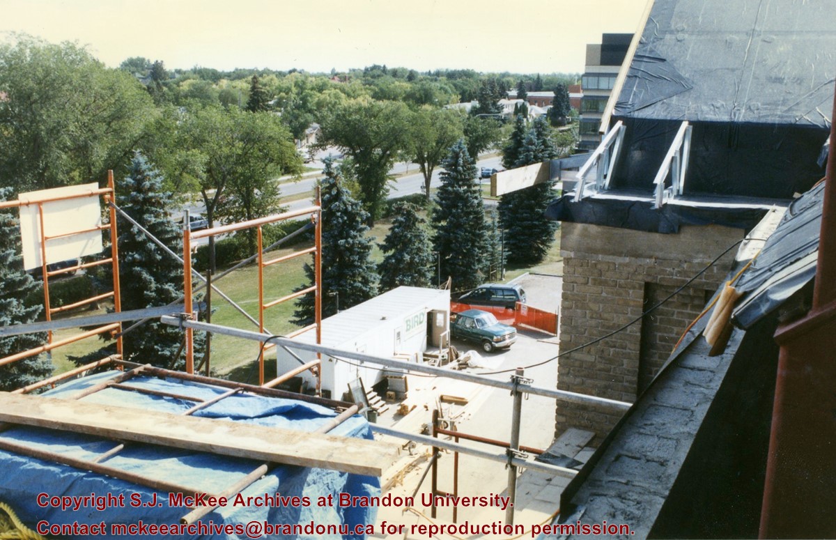
View is southeast from the roof of Clark Hall. Photograph shows some of the scaffolding and materials, as well as the construction trailer (Bird Construction) located on the driveway during the restoration of Clark Hall and the Brandon College Building.
Subject Access
campus photographs
campus construction
Images
Show Less

Brandon University campus construction

http://archives.brandonu.ca/en/permalink/descriptions8008
Part Of
Brandon University Photograph collection
Description Level
Item
GMD
graphic
Date Range
c. 1996
Part Of
Brandon University Photograph collection
Description Level
Item
Series Number
2.1
Item Number
BUPC 2.1.74
GMD
graphic
Date Range
c. 1996
Physical Description
6" x 4" (colour)
Scope and Content
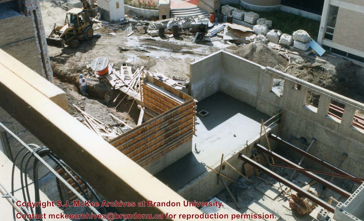
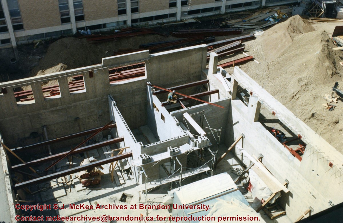
View is southwest from Clark Hall. Photograph shows the construction of the foundation of the extension of Clark Hall and various construction materials located in the courtyard.
Subject Access
campus photographs
campus construction
Images
Show Less

Brandon University campus construction

http://archives.brandonu.ca/en/permalink/descriptions8009
Part Of
Brandon University Photograph collection
Description Level
Item
GMD
graphic
Date Range
c. 1996
Part Of
Brandon University Photograph collection
Description Level
Item
Series Number
2.1
Item Number
BUPC 2.1.75
GMD
graphic
Date Range
c. 1996
Physical Description
6" x 4" (colour)
Scope and Content
View is west from Clark Hall. Photograph shows the construction of the foundation of the extension of Clark Hall.
Subject Access
campus photographs
campus construction
Images
Show Less

20 records – page 1 of 1.