Photograph shows Princess Avenue facing east from 10th Street. On the north side of Princess Avenue, a B/A Service Station, Princess Cafe, Lindenberg Seeds, and the Central Fire Station are visible. Old City Hall with the war memorial and the Prince Edward Hotel are visible on the south side of Princess Avenue. Traffic is travelling one-way on Princess Avenue.
The Medicine Hat Exhibition and Stampede Parade Day was held on Thursday, July 19, 1962, at 9:30 a.m. The local newspaper reported that approximately 24,000 people were in attendance to see parade marshall Rod Ashburner leading 175 entries consisting of 90 floats, 75 horses, and 10 bands. There were 19 parade categories eligible for $12,000 in prize money and included: junior and senior cowboys and cowgirls; fancy and Shetland ponies; sulky class open; comic, commercial, industrial and organizational floats; decorated cars; special ranch class; 4-H Clubs; and a non-competitive class.
The parade route started at Second St. and Allowance Ave., from Second St. to Ash Ave., north on Ash to First St. SE., from First St. S.E. to Fourth Ave., south to Second St. to South Railway St., south on South Railway St. to Third St., with a finish at McLeod Trail. A route map was published in the Medicine Hat News the day before the parade.
Aerial photographs of the parade were taken by Medicine Hat News photographer Howard Heid (1930-2005) from the private helicopter of John Bourn. Bourn was a pilot from Woodville, Wisconsin, who chartered his four-seater helicopter for sight-seers at exhibitions and stampedes across the county.
(Sources: Pat Currie, "Let 'Er Go!," Medicine Hat News, 19 July 1962,1; Harald Gunderson, "'Eye in the Sky' Best Parade View," Medicine Hat News, 19 July 1962,1; "Parade Starts at 9:30 Sharp," 18 July 1962)
Scope and Content
Photograph shows an aerial view of the Medicine Hat Exhibition and Stampede Parade route with a focus on the First Street SE and Sixth Avenue intersection. A number of gas stations and garages are visible along this route and include Texaco, Shell, Ford, and B/A. A number of observers can be seen sitting on rooftops.
Notes
This photograph shows the neighbourhood before rezoning and commercial development.
The Medicine Hat Exhibition and Stampede Parade Day was held on Thursday, July 19, 1962, at 9:30 a.m. The local newspaper reported that approximately 24,000 people were in attendance to see parade marshall Rod Ashburner leading 175 entries consisting of 90 floats, 75 horses, and 10 bands. There were 19 parade categories eligible for $12,000 in prize money and included: junior and senior cowboys and cowgirls; fancy and Shetland ponies; sulky class open; comic, commercial, industrial and organizational floats; decorated cars; special ranch class; 4-H Clubs; and a non-competitive class.
The parade route started at Second St. and Allowance Ave., from Second St. to Ash Ave., north on Ash to First St. SE., from First St. S.E. to Fourth Ave., south to Second St. to South Railway St., south on South Railway St. to Third St., with a finish at McLeod Trail. A route map was published in the Medicine Hat News the day before the parade.
Aerial photographs of the parade were taken by Medicine Hat News photographer Howard Heid (1930-2005) from the private helicopter of John Bourn. Bourn was a pilot from Woodville, Wisconsin, who chartered his four-seater helicopter for sight-seers at exhibitions and stampedes across the county.
(Sources: Pat Currie, "Let 'Er Go!," Medicine Hat News, 19 July 1962,1; Harald Gunderson, "'Eye in the Sky' Best Parade View," Medicine Hat News, 19 July 1962,1; "Parade Starts at 9:30 Sharp," 18 July 1962)
Scope and Content
Photograph shows an aerial view of the Medicine Hat Exhibition and Stampede Parade route, with a focus on Second Street SE. Visible store signs include: Gardener's Used Cars, Provincial Treasury Branch, Furvey's Furniture and Appliances, J.J. Moore & Son Furniture, Alberta Credit Jewellers, James Richardson & Sons, Medicine Hat Gas Power Water City Owned Utilities.
Notes
This photograph shows the neighbourhood before rezoning and commercial development.
The Medicine Hat Exhibition and Stampede Parade Day was held on Thursday, July 19, 1962, at 9:30 a.m. The local newspaper reported that approximately 24,000 people were in attendance to see parade marshall Rod Ashburner leading 175 entries consisting of 90 floats, 75 horses, and 10 bands. There were 19 parade categories eligible for $12,000 in prize money and included: junior and senior cowboys and cowgirls; fancy and Shetland ponies; sulky class open; comic, commercial, industrial and organizational floats; decorated cars; special ranch class; 4-H Clubs; and a non-competitive class.
The parade route started at Second St. and Allowance Ave., from Second St. to Ash Ave., north on Ash to First St. SE., from First St. S.E. to Fourth Ave., south to Second St. to South Railway St., south on South Railway St. to Third St., with a finish at McLeod Trail. A route map was published in the Medicine Hat News the day before the parade.
Aerial photographs of the parade were taken by Medicine Hat News photographer Howard Heid (1930-2005) from the private helicopter of John Bourn. Bourn was a pilot from Woodville, Wisconsin, who chartered his four-seater helicopter for sight-seers at exhibitions and stampedes across the county.
(Sources: Pat Currie, "Let 'Er Go!," Medicine Hat News, 19 July 1962,1; Harald Gunderson, "'Eye in the Sky' Best Parade View," Medicine Hat News, 19 July 1962,1; "Parade Starts at 9:30 Sharp," 18 July 1962)
Scope and Content
Photograph shows an aerial view of the Medicine Hat Exhibition and Stampede Parade route with a focus on the First Street SE. A number of gas stations and garages are visible along this route and include Texaco, Shell, Ford, and B/A. The Fraternal Order of Eagles lodge is also visible.
Notes
This photograph appeared on the front page of The Medicine Hat News (19 July 1962).
The Medicine Hat Exhibition and Stampede Parade Day was held on Thursday, July 19, 1962, at 9:30 a.m. The local newspaper reported that approximately 24,000 people were in attendance to see parade marshall Rod Ashburner leading 175 entries consisting of 90 floats, 75 horses, and 10 bands. There were 19 parade categories eligible for $12,000 in prize money and included: junior and senior cowboys and cowgirls; fancy and Shetland ponies; sulky class open; comic, commercial, industrial and organizational floats; decorated cars; special ranch class; 4-H Clubs; and a non-competitive class.
The parade route started at Second St. and Allowance Ave., from Second St. to Ash Ave., north on Ash to First St. SE., from First St. S.E. to Fourth Ave., south to Second St. to South Railway St., south on South Railway St. to Third St., with a finish at McLeod Trail. A route map was published in the Medicine Hat News the day before the parade.
Aerial photographs of the parade were taken by Medicine Hat News photographer Howard Heid (1930-2005) from the private helicopter of John Bourn. Bourn was a pilot from Woodville, Wisconsin, who chartered his four-seater helicopter for sight-seers at exhibitions and stampedes across the county.
(Sources: Pat Currie, "Let 'Er Go!," Medicine Hat News, 19 July 1962,1; Harald Gunderson, "'Eye in the Sky' Best Parade View," Medicine Hat News, 19 July 1962,1; "Parade Starts at 9:30 Sharp," 18 July 1962)
Scope and Content
Photograph shows an aerial view of the Medicine Hat Exhibition and Stampede Parade route with a focus on the First Street SE and and the South Railway Street merge. A number of gas stations and garages are visible along this route and include Texaco, Shell, Ford, and B/A. The Fraternal Order of Eagles lodge is also visible.
Notes
This photograph shows the neighbourhood before rezoning and commercial development.
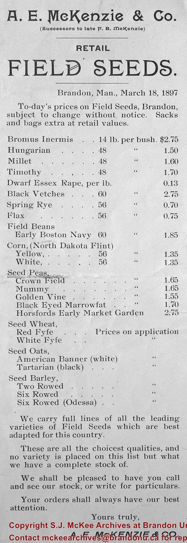
Postcard was sent to Chuck Wilson's aunt, Mrs. W.M. Wilson in Creelman, SK by the McKenzie Seed Company in 1912. Chuck Wilson found the postcard in some of his aunt's papers in 2009 and mailed it to the McKee Archives.
Scope and Content
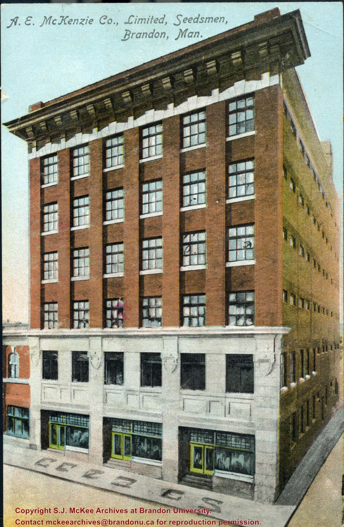
Item consists of a colour postcard of the McKenzie Seed Company building located on the west side of the 100 block of 9th Street. The card was sent to Mrs. W.M. Wilson of Creelman, SK to acknowledge her order.
Writing on the front of the card reads: A.E. McKenzie Co., Limited, Seedsmen, Brandon, Man
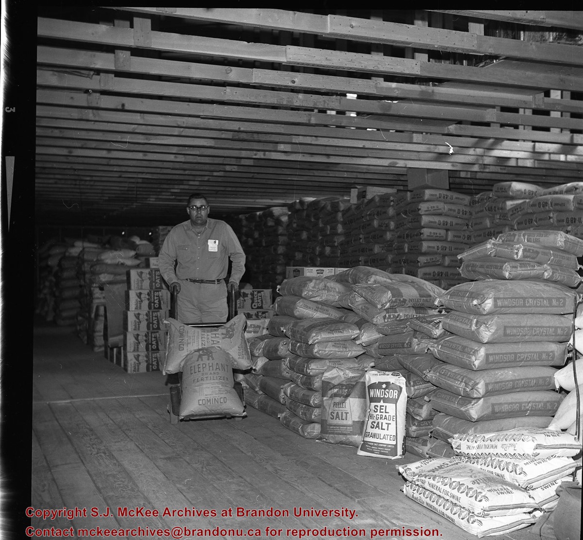
Manitoba Flying Farmers Convention appears to have been a convention for farmers who planted and sprayed their crops using aerial techniques. The Manitoba Flying Farmers were organized in 1956 in Brandon, Manitoba. Organizational meetings were held in a hanger at the Brandon Flying Club. The first Regional 5 Flying Farmers Convention in Manitoba was held 1961. Nearly 200 people attended the first convention from various provinces and states including: Alberta, Saskatchewan, North Dakota, South Dakota, Minnisota, Wisconsin, Montana and Colorado. Alberta and Saskatchewan had their own district leaving Manitoba in a district with North Dakota, South Dakota, Minnisota and Wisconsin. This photo was taken at the 11th Annual Manitoba Flying Farmers Convention on the weekend of April 7th, 1967.
Custodial History
See Fonds level description for custodial history
Scope and Content
Image of a woman presenting at the podium from the front table. Two men are sitting on either side of the woman. A sign saying "Manitoba Flying Farmers" is at the base of the table. The image appears to have been taken at the Prince Edward Hotel.
Notes
Hisotry/Bio information taken from Brandon Sun. Description by Jillian Combs.
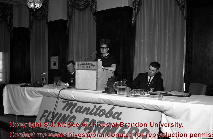
Manitoba Flying Farmers Convention appears to have been a convention for farmers who planted and sprayed their crops using aerial techniques. The Manitoba Flying Farmers were organized in 1956 in Brandon, Manitoba. Organizational meetings were held in a hanger at the Brandon Flying Club. The first Regional 5 Flying Farmers Convention in Manitoba was held 1961. Nearly 200 people attended the first convention from various provinces and states including: Alberta, Saskatchewan, North Dakota, South Dakota, Minnisota, Wisconsin, Montana and Colorado. Alberta and Saskatchewan had their own district leaving Manitoba in a district with North Dakota, South Dakota, Minnisota and Wisconsin. This photo was taken at the 11th Annual Manitoba Flying Farmers Convention on the weekend of April 7th, 1967.
Custodial History
See Fonds level description for custodial history
Scope and Content
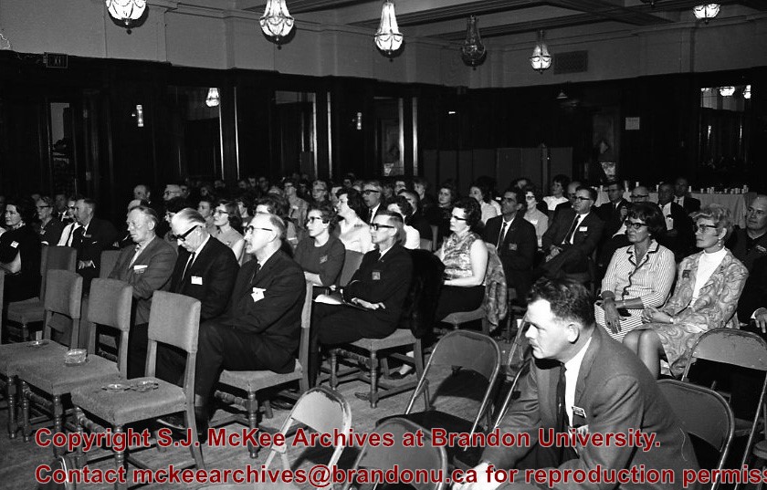
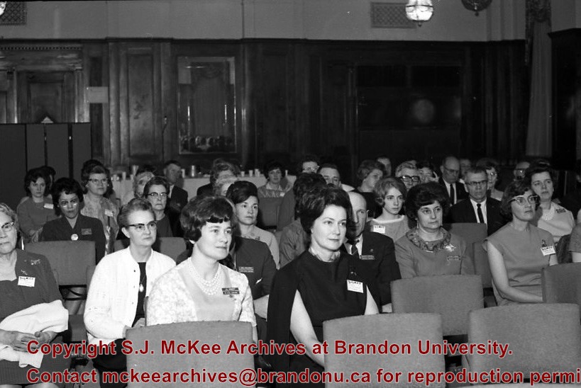
Image of the attendants of the convention who are listening to the speaker. The image appears to have been taken in the Prince Edward Hotel.
Notes
Hisotry/Bio information taken from Henderson's Directories. Description by Jillian Combs.
Manitoba Flying Farmers Convention appears to have been a convention for farmers who planted and sprayed their crops using aerial techniques. The Manitoba Flying Farmers were organized in 1956 in Brandon, Manitoba. Organizational meetings were held in a hanger at the Brandon Flying Club. The first Regional 5 Flying Farmers Convention in Manitoba was held 1961. Nearly 200 people attended the first convention from various provinces and states including: Alberta, Saskatchewan, North Dakota, South Dakota, Minnisota, Wisconsin, Montana and Colorado. Alberta and Saskatchewan had their own district leaving Manitoba in a district with North Dakota, South Dakota, Minnisota and Wisconsin. This photo was taken at the 11th Annual Manitoba Flying Farmers Convention on the weekend of April 7th, 1967.
Custodial History
See Fonds level description for custodial history
Scope and Content
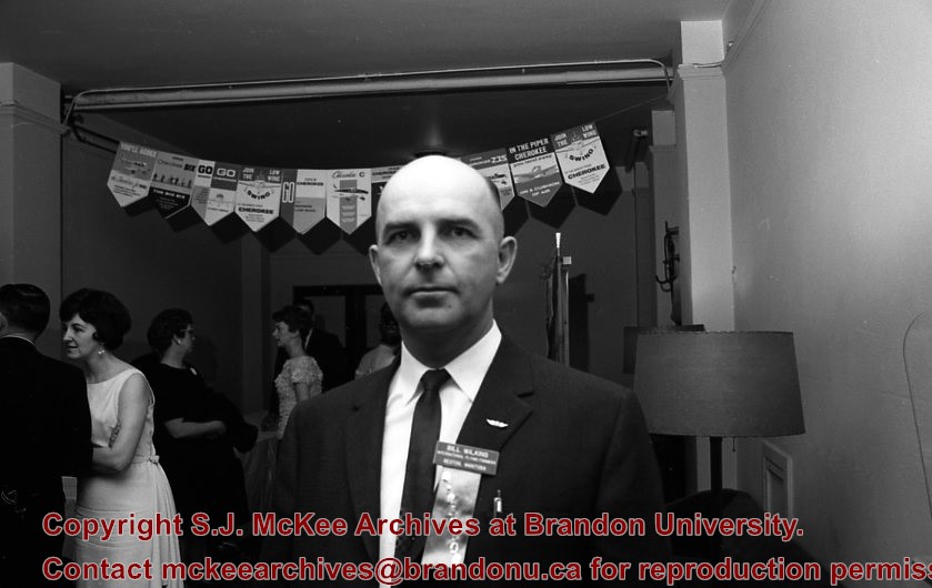
Image of convention attendee. Based on the name tag he appears to be Bill Williams (?). Image appears to have been taken inside the Prince Edward hotel. There is a banner in the background.
Manitoba Flying Farmers Convention appears to have been a convention for farmers who planted and sprayed their crops using aerial techniques.. The Manitoba Flying Farmers were organized in 1956 in Brandon, Manitoba. Organizational meetings were held in a hanger at the Brandon Flying Club. The first Regional 5 Flying Farmers Convention in Manitoba was held 1961. Nearly 200 people attended the first convention from various provinces and states including: Alberta, Saskatchewan, North Dakota, South Dakota, Minnisota, Wisconsin, Montana and Colorado. Alberta and Saskatchewan had their own district leaving Manitoba in a district with North Dakota, South Dakota, Minnisota and Wisconsin. This photo was taken at the 11th Annual Manitoba Flying Farmers Convention on the weekend of April 7th, 1967.
Custodial History
See Fonds level description for custodial history
Scope and Content
Image of convention attendants listening to the speaker. There is a large number of women in the audience.The large number of women in the photo could be attributed to Flying Farmers queens of each distrcits encouragement of women learning to fly. The image appears to have been taken at the Prince Edward Hotel.


