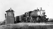
The Towerman controlled the crossing gates, [as well as] switches and signals for all routes into and out of the station and freight yards. [Mr. Stuckey's] grandfather, Samuel Gilmour, operated the previous tower for many years (which only operated the crossing gates), and continued to operate the new tower for several years after it was built (ca. 1929). This tower was made obsolete with the installation of Centralized Traffic Control in 1965.
Custodial History
For custodial history see the collection level description of the Lawrence Stuckey collection.
Scope and Content
Canadian Pacific Railway's18th Street crossing & signal tower.
Notes
Photo taken just before construction started on overpass
For a better picture of this tower see photo No. 53 (engine 2911) in CPR steam trains file
The McKee Archives is the copyright holder for the Stuckey materials.
Location Copy
1-2002.3.9.163
Storage Location
Lawrence Stuckey collection
Arrangement
[Mr. Stuckey numbered two envelopes P20. We have kept the same number but designated the first envelope P20(1) and the contents of the second envelope P20(2) and P20(3).]
For custodial history see the collection level description of the Lawrence Stuckey collection.
Scope and Content
West side of Sixth Street, north of Rosser Avenue; looking north
Notes
Businesses displayed (S to N) include: Winter & O'Neill - general store; James A. Smart - hardware; Grand Central Hotel - built 1882, razed 1890; American House - hotel; Brandon House (far end) - hotel
The Queen's hotel was located on the corner of Rosser Avenue and Tenth Street (Steen & Boyce, 1882. Brandon, Manitoba, Canada and Her Industries. Steen & Boyce Publishers Printers & Binders, 81.). Therefore this photo appears to display Rosser Avenue looking east. P.E. 11/06/09
Custodial History
For custodial history see the collection level description of the Lawrence Stuckey collection.
Scope and Content
Queen's Hotel, Robinson Bros. & Co. Drygoods, etc.
Notes
Street scene with new construction. Collection: Fred McGuinness
For custodial history see the collection level description of the Lawrence Stuckey collection.
Scope and Content
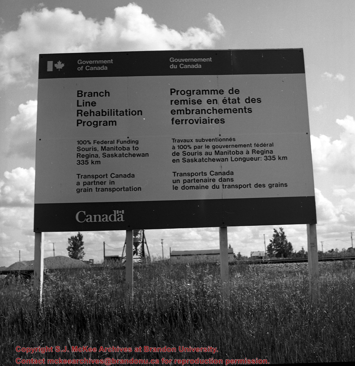
Image of a Prairie Branchline Rehabilitation Sign near Reston, Manitoba. Image was taken along the CPR lines south of the mainline.
Notes
[Image is of a Government of Canada sign which reads: Branch Line Rehabilitation Program. 100% federal funding. Souris, Manitoba to Regina Saskatchewan 335 km. Transport Canada, a partner in grain transportation].
For custodial history see the collection level description of the Lawrence Stuckey collection.
Scope and Content
10th Street Commercial Block
Notes
The Commercial Block is located on the east side of the 100 block of 10th Street, directly south of the Hughes Block.
[Mr. Stuckey put two negatives and two prints in one envelope. We have separated them and numbered the negatives EA2(1) and EA2(2), and the prints EA2(1a) and EA2(2a).]
For custodial history see the collection level description of the Lawrence Stuckey collection.
Scope and Content
This image shows commercial buildings located on the west side of the 100 block of 10th Street.
Businesses shown include Doig's Home Furnishings
Notes
[Mr. Stuckey put three negatives and three prints in same envelope. We have separated them and numbered the negatives EA4(1) through EA4(3), and the prints EA4(1a) through EA4(3a).]
From the late 1960s until the late 1980s the original Science Building was used to house Brandon University's Drama Department. Since the late 1980s this building has been home to the Brandon University Students' Union, and in now known as the Knowles Douglas Students’ Union Centre (T.M. 09/06/09).
Custodial History
For custodial history see the collection level description of the Lawrence Stuckey collection.
Scope and Content
Brandon College campus buildings, [(L to R): Citizens' Science Building, Brandon College Building, Clark Hall]
.jpg?width=1200&404=no-img.jpg&watermark=wmk)
.jpg?width=180&404=no-img.jpg)


.jpg?width=1200&404=no-img.jpg&watermark=wmk)
.jpg?width=180&404=no-img.jpg)
.jpg?width=1200&404=no-img.jpg&watermark=wmk)
.jpg?width=180&404=no-img.jpg)
.jpg?width=1200&404=no-img.jpg&watermark=wmk)
.jpg?width=180&404=no-img.jpg)
.jpg?width=1200&404=no-img.jpg&watermark=wmk)
.jpg?width=180&404=no-img.jpg)
.jpg?width=1200&404=no-img.jpg&watermark=wmk)
.jpg?width=180&404=no-img.jpg)
.jpg?width=1200&404=no-img.jpg&watermark=wmk)
.jpg?width=180&404=no-img.jpg)
.jpg?width=1200&404=no-img.jpg&watermark=wmk)
.jpg?width=180&404=no-img.jpg)
.jpg?width=1200&404=no-img.jpg&watermark=wmk)
.jpg?width=180&404=no-img.jpg)
.jpg?width=1200&404=no-img.jpg&watermark=wmk)
.jpg?width=180&404=no-img.jpg)
.jpg?width=1200&404=no-img.jpg&watermark=wmk)
.jpg?width=180&404=no-img.jpg)
.jpg?width=1200&404=no-img.jpg&watermark=wmk)
.jpg?width=180&404=no-img.jpg)
.jpg?width=1200&404=no-img.jpg&watermark=wmk)
.jpg?width=180&404=no-img.jpg)
.jpg?width=1200&404=no-img.jpg&watermark=wmk)
.jpg?width=180&404=no-img.jpg)
.jpg?width=1200&404=no-img.jpg&watermark=wmk)
.jpg?width=180&404=no-img.jpg)
.jpg?width=1200&404=no-img.jpg&watermark=wmk)
.jpg?width=180&404=no-img.jpg)
.jpg%3fmaxheight%3d1000%26maxwidth%3d1000%26watermark%3dwmk&description=CPR+18th+Street+crossing+%26+signal+tower)
.jpg%3fmaxheight%3d1000%26maxwidth%3d1000%26watermark%3dwmk&description=10th+Street+Commercial+Block)
.jpg%3fmaxheight%3d1000%26maxwidth%3d1000%26watermark%3dwmk&description=10th+Street+Commercial+Block)
.jpg%3fmaxheight%3d1000%26maxwidth%3d1000%26watermark%3dwmk&description=10th+Street+Commercial+Block)
.jpg%3fmaxheight%3d1000%26maxwidth%3d1000%26watermark%3dwmk&description=10th+Street+Commercial+Block)
.jpg%3fmaxheight%3d1000%26maxwidth%3d1000%26watermark%3dwmk&description=10th+Street+Businesses+-+West+Side+of+100+Block)
.jpg%3fmaxheight%3d1000%26maxwidth%3d1000%26watermark%3dwmk&description=10th+Street+Businesses+-+West+Side+of+100+Block)
.jpg%3fmaxheight%3d1000%26maxwidth%3d1000%26watermark%3dwmk&description=Brandon+College+scenes)
.jpg%3fmaxheight%3d1000%26maxwidth%3d1000%26watermark%3dwmk&description=Brandon+College+scenes)
.jpg%3fmaxheight%3d1000%26maxwidth%3d1000%26watermark%3dwmk&description=Brandon+College+scenes)
.jpg%3fmaxheight%3d1000%26maxwidth%3d1000%26watermark%3dwmk&description=Brandon+College+scenes)
.jpg%3fmaxheight%3d1000%26maxwidth%3d1000%26watermark%3dwmk&description=Brandon+College+scenes)
.jpg%3fmaxheight%3d1000%26maxwidth%3d1000%26watermark%3dwmk&description=Brandon+College+scenes)
.jpg%3fmaxheight%3d1000%26maxwidth%3d1000%26watermark%3dwmk&description=Brandon+College+scenes)
.jpg%3fmaxheight%3d1000%26maxwidth%3d1000%26watermark%3dwmk&description=Brandon+College+scenes)
.jpg%3fmaxheight%3d1000%26maxwidth%3d1000%26watermark%3dwmk&description=Brandon+College+scenes)