One small hole, some pencil marks and stains. A couple of the names are illegible.
History / Biographical
The Brandon Normal School was an arm of the provincial Department of Education. Manitoba Normal schools were initiated in the early 1880s (1882 for protestant teachers and 1883 for Roman Catholic ones) to meet the demand for teachers in the province's schools. Normal schools were held in Brandon at various locations until the construction of the Brandon Normal School in 1912 under the Roblin government. The Brandon Normal School operated until 1946.
Custodial History
Photograph was donated to the McKee Archives by Janette Donnelly in 1999.
Scope and Content
Portraits of the students and staff of Brandon Normal School's third class spring term (1921).
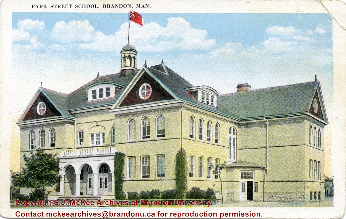
Located south of Stanley Park along the 1400 block of Lorne Avenue, Park School was constructed in 1904. Designed by W.A. Elliot and built by the Brandon Construction Company the structure measured 71 x 107 feet and cost approximately $38,000.
The school featured a principal’s office, reception room, staff rooms, an assembly hall for eight hundred, and ten class rooms. The interior walls were lined with mahogany while the floors were made of western pine. The interior of the basement was constructed from Tyndall stone, while Crookston brick trimmed with Bedford stone made up the exterior.
The building was razed in September 1978. Hobbes Manor was built on the location.
Scope and Content
Item is a postcard showing Park School in Brandon, MB.
Photograph is looking northwest probably from the northwest corner of 18th Street and Louise Avenue. The photographer was laying down when s/he took the shot. Photograph shows the field to the south of the Citizens' Science Building, as well as the Citizens' Science Building, part of the Brandon College Building and Clark Hall, and two H-Huts. The photo was taken in summer as the field is full of dandelions.
View is southwest from approximately 18th Street and Lorne Avenue. Photograph shows the Brandon University campus in winter, including: the Brandon University sign, the John R. Brodie Science Centre, the Citizens' Science Building and McMaster Hall.
View is southwest from the north side of Princess Avenue. Photograph shows the original Music Building, the north driveway entrance and parts of Clark Hall and the Brandon College building.
View is southwest from the sidewalk on the west side of 18th Street. Photograph shows the Brandon University sign, the front lawn, the Citizens' Science Building, McMaster Hall and the John R. Brodie Science Centre.
View is south from the north side of Princess Avenue. Photograph shows the walkway leading south across campus, the original Music Building, the A.E. McKenzie Building, the J.R.C. Evans Lecture Theatre, Flora Cowan Hall and Darrach Hall.
View is southwest from Princess Avenue. Photograph shows the original Music Building, the A.E. McKenzie Building, the J.R.C. Evans Lecture Theatre and Darrach Hall. Also visible are the field where the Western Manitoba Centennial Auditorium now stands, as well as a number of houses on 20th Street.
/17-2011_7.jpg?width=1200&404=no-img.jpg&watermark=wmk)
/17-2011_7.jpg?width=180&404=no-img.jpg)
/17-2011_14.jpg?width=1200&404=no-img.jpg&watermark=wmk)
/17-2011_14.jpg?width=180&404=no-img.jpg)
/17-2011_1.jpg?width=1200&404=no-img.jpg&watermark=wmk)
/17-2011_1.jpg?width=180&404=no-img.jpg)
/17-2011_3.jpg?width=1200&404=no-img.jpg&watermark=wmk)
/17-2011_3.jpg?width=180&404=no-img.jpg)
/17-2011_4.jpg?width=1200&404=no-img.jpg&watermark=wmk)
/17-2011_4.jpg?width=180&404=no-img.jpg)
/17-2011_5.jpg?width=1200&404=no-img.jpg&watermark=wmk)
/17-2011_5.jpg?width=180&404=no-img.jpg)
/17-2011_12.jpg?width=1200&404=no-img.jpg&watermark=wmk)
/17-2011_12.jpg?width=180&404=no-img.jpg)
/17-2011_8.jpg?width=1200&404=no-img.jpg&watermark=wmk)
/17-2011_8.jpg?width=180&404=no-img.jpg)
/17-2011_10.jpg?width=1200&404=no-img.jpg&watermark=wmk)
/17-2011_10.jpg?width=180&404=no-img.jpg)
/17-2011_11.jpg?width=1200&404=no-img.jpg&watermark=wmk)
/17-2011_11.jpg?width=180&404=no-img.jpg)
/17-2011_9.jpg?width=1200&404=no-img.jpg&watermark=wmk)
/17-2011_9.jpg?width=180&404=no-img.jpg)
/17-2011_6.jpg?width=1200&404=no-img.jpg&watermark=wmk)
/17-2011_6.jpg?width=180&404=no-img.jpg)


%2f17-2011_7.jpg%3fmaxheight%3d1000%26maxwidth%3d1000%26watermark%3dwmk&description=Brandon+Indian+School)
%2f17-2011_14.jpg%3fmaxheight%3d1000%26maxwidth%3d1000%26watermark%3dwmk&description=Residence+at+the+Brandon+Indian+Residential+School)
%2f17-2011_1.jpg%3fmaxheight%3d1000%26maxwidth%3d1000%26watermark%3dwmk&description=View+from+top+of+school+building)
%2f17-2011_3.jpg%3fmaxheight%3d1000%26maxwidth%3d1000%26watermark%3dwmk&description=School+entrance)
%2f17-2011_4.jpg%3fmaxheight%3d1000%26maxwidth%3d1000%26watermark%3dwmk&description=Principal%27s+residence)
%2f17-2011_5.jpg%3fmaxheight%3d1000%26maxwidth%3d1000%26watermark%3dwmk&description=Barn+Avenue)
%2f17-2011_12.jpg%3fmaxheight%3d1000%26maxwidth%3d1000%26watermark%3dwmk&description=Brandon+Indian+School+soccer+team)
%2f17-2011_8.jpg%3fmaxheight%3d1000%26maxwidth%3d1000%26watermark%3dwmk&description=Brandon+Indian+School+farm)
%2f17-2011_10.jpg%3fmaxheight%3d1000%26maxwidth%3d1000%26watermark%3dwmk&description=Brandon+Indian+School+garden+boys)
%2f17-2011_11.jpg%3fmaxheight%3d1000%26maxwidth%3d1000%26watermark%3dwmk&description=Brandon+Indian+School+garden+boys)
%2f17-2011_9.jpg%3fmaxheight%3d1000%26maxwidth%3d1000%26watermark%3dwmk&description=Ironing)
%2f17-2011_6.jpg%3fmaxheight%3d1000%26maxwidth%3d1000%26watermark%3dwmk&description=Making+the+Ford+work+for+its+keep)