For custodial history see the collection level description of the Lawrence Stuckey collection.
Scope and Content
View of Assiniboine Avenue running west, from Ninth Street North
Notes
Second building from right - Westbrook & Fairchild Implements. At left - Western Hotel; Data [courtesy of] Roy Brown from Henderson's [Directory]; From Manitoba Archives
Photograph shows a southwest view of the Prince Edward Hotel and train station.
Notes
Part of "Souvenir of Brandon, Manitoba, Canada [viewbook], Printed by Photogelatine Engraving Co. Limited, Ottawa." Dates obtained from the Burchill's Music Store Henderson's Brandon City Directory listings (1927-1929). Writing on the front of the photograph reads: Prince Edward Hotel, Brandon, Man.
Photograph shows the Greyhound Bus Depot at 11th Street and Princess Avenue. Western Motors, Wheelers Esso Station, and the Prince Edward Hotel are visible along the south side of Princess Avenue. Traffic is travelling one-way on Princess Avenue.
For custodial history see the collection level description of the Lawrence Stuckey collection.
Scope and Content
West side of Sixth Street, north of Rosser Avenue; looking north
Notes
Businesses displayed (S to N) include: Winter & O'Neill - general store; James A. Smart - hardware; Grand Central Hotel - built 1882, razed 1890; American House - hotel; Brandon House (far end) - hotel
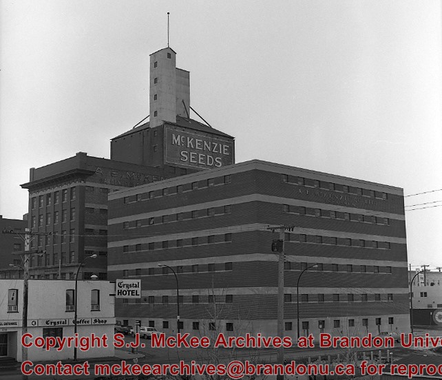
Photograph shows a panorama, bird's-eye-view of downtown Brandon, between Pacific and Rosser Avenues and 7th Street facing east. Photoraph likely taken from the McKenzie Seeds Building. Visible businesses include: Western Canada Flour Mills, Hanbury Hardware Co. Ltd., Cockshutt Plow Co., New Pacific Hotel, Gordon McKay Building, and Arlington Hotel.
Notes
Part of "Souvenir of Brandon, Manitoba, Canada [viewbook], Printed by Photogelatine Engraving Co. Limited, Ottawa." Dates obtained from the Burchill's Music Store Henderson's Brandon City Directory listings (1927-1929). Writing on the front of the photograph reads: Panorama of Brandon, Man.
Photograph shows the north face of the Prince Edward Hotel on Princess Avenue. To the east of the hotel is Old City Hall with the military monument (which has since been relocated to the Brandon Armoury). On the west side of the hotel is Wheelers Esso Service Station.
Notes
The photograph appears to be taken from the Hughes Building on 10th Street.
For custodial history see the collection level description of the Lawrence Stuckey collection.
Scope and Content
Southeast corner of 10th Street and Princess Ave. Showing: Prince Edward Hotel being demolished, part of Imperial Oil Building, new construction for corner building.
For custodial history see the collection level description of the Lawrence Stuckey collection.
Scope and Content
Southeast corner of 10th Street and Princess Ave. Showing: Prince Edward Hotel being demolished, part of Imperial Oil Building, new construction for corner building.
For custodial history see the collection level description of the Lawrence Stuckey collection.
Scope and Content
Southeast corner of 10th Street and Princess Ave. Showing: Prince Edward Hotel being demolished, part of Imperial Oil Building, new construction for corner building.
Photograph shows Princess Avenue facing east from 10th Street. On the north side of Princess Avenue, a B/A Service Station, Princess Cafe, Lindenberg Seeds, and the Central Fire Station are visible. Old City Hall with the war memorial and the Prince Edward Hotel are visible on the south side of Princess Avenue. Traffic is travelling one-way on Princess Avenue.
For custodial history see the collection level description of the Lawrence Stuckey collection.
Scope and Content
View of the southeast corner of Tenth Street and Princess Avenue, showing the Prince Edward Hotel (left) and an Imperial Oil Building (right).
Notes
The second floor of the Imperial Oil building became the Imperial Dance Garden in 1934. The small wooden post in a concrete foundation in the centre of the intersection was called a "Silent Policeman". You were supposed to keep it on your left while making a left turn. They took quite a beating.
[Information in "Notes" provided by the Fred McGuinness collection (20-2009).]
Photograph shows the Brandon Wheat Market along Pacific Avenue on November 30, 1885. Farmers can be seen driving wagon teams loaded with bags of grain in line on Pacific Avenue from 10 Street to at least 7th Street. On the north side of Pacific Avenue the CPR Land Office and grain elevators are pictured. On the south side of Pacific Avenue, the general merchant/hardware store Bower, Blackburn, Mundell & Porter is situated on the corner of Pacific Avenue and 10th Street. A 10th Street sign is affixed to the merchants' store. On the east side of the general store, Edie House, the Grand View Hotel, and a Farmers' boarding and lodging house can be seen. Most of the buildings appear to be woodframed except for the Grand View, which is constructed of brick. Sidewalks appear to be in place on the south side of Pacific and snow dusts the streets. A baby swathed in winter clothing sits in a pram/baby carriage in front of the general store.
Notes
Writing on the front of the photograph reads: Novemeber 30th, 1885, Brandon Wheat Market
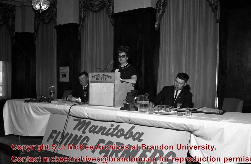
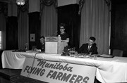
Manitoba Flying Farmers Convention appears to have been a convention for farmers who planted and sprayed their crops using aerial techniques. The Manitoba Flying Farmers were organized in 1956 in Brandon, Manitoba. Organizational meetings were held in a hanger at the Brandon Flying Club. The first Regional 5 Flying Farmers Convention in Manitoba was held 1961. Nearly 200 people attended the first convention from various provinces and states including: Alberta, Saskatchewan, North Dakota, South Dakota, Minnisota, Wisconsin, Montana and Colorado. Alberta and Saskatchewan had their own district leaving Manitoba in a district with North Dakota, South Dakota, Minnisota and Wisconsin. This photo was taken at the 11th Annual Manitoba Flying Farmers Convention on the weekend of April 7th, 1967.
Custodial History
See Fonds level description for custodial history
Scope and Content
Image of a woman presenting at the podium from the front table. Two men are sitting on either side of the woman. A sign saying "Manitoba Flying Farmers" is at the base of the table. The image appears to have been taken at the Prince Edward Hotel.
Notes
Hisotry/Bio information taken from Brandon Sun. Description by Jillian Combs.
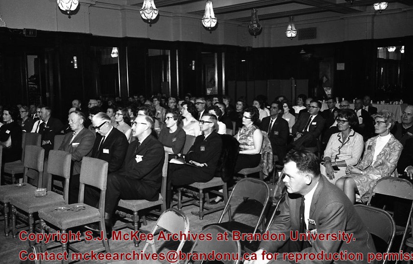
Manitoba Flying Farmers Convention appears to have been a convention for farmers who planted and sprayed their crops using aerial techniques. The Manitoba Flying Farmers were organized in 1956 in Brandon, Manitoba. Organizational meetings were held in a hanger at the Brandon Flying Club. The first Regional 5 Flying Farmers Convention in Manitoba was held 1961. Nearly 200 people attended the first convention from various provinces and states including: Alberta, Saskatchewan, North Dakota, South Dakota, Minnisota, Wisconsin, Montana and Colorado. Alberta and Saskatchewan had their own district leaving Manitoba in a district with North Dakota, South Dakota, Minnisota and Wisconsin. This photo was taken at the 11th Annual Manitoba Flying Farmers Convention on the weekend of April 7th, 1967.
Custodial History
See Fonds level description for custodial history
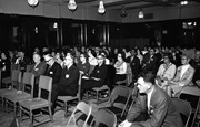
Scope and Content
Image of the attendants of the convention who are listening to the speaker. The image appears to have been taken in the Prince Edward Hotel.
Notes
Hisotry/Bio information taken from Henderson's Directories. Description by Jillian Combs.


.jpg?width=1200&404=no-img.jpg&watermark=wmk)
.jpg?width=180&404=no-img.jpg)
.jpg?width=1200&404=no-img.jpg&watermark=wmk)
.jpg?width=180&404=no-img.jpg)


.jpg?width=1200&404=no-img.jpg&watermark=wmk)
.jpg?width=180&404=no-img.jpg)
.jpg?width=1200&404=no-img.jpg&watermark=wmk)
.jpg?width=180&404=no-img.jpg)
.jpg?width=1200&404=no-img.jpg&watermark=wmk)
.jpg?width=180&404=no-img.jpg)


.jpg%3fmaxheight%3d1000%26maxwidth%3d1000%26watermark%3dwmk&description=East+view+from+100+block+of+Tenth+Street)
.jpg%3fmaxheight%3d1000%26maxwidth%3d1000%26watermark%3dwmk&description=East+view+from+100+block+of+Tenth+Street)
.jpg%3fmaxheight%3d1000%26maxwidth%3d1000%26watermark%3dwmk&description=Prince+Edward+Hotel+demolition)
.jpg%3fmaxheight%3d1000%26maxwidth%3d1000%26watermark%3dwmk&description=Prince+Edward+Hotel+demolition)
.jpg%3fmaxheight%3d1000%26maxwidth%3d1000%26watermark%3dwmk&description=Prince+Edward+Hotel+demolition)