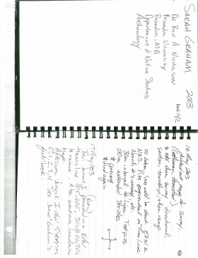
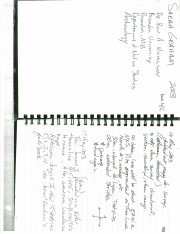
In 2003 Units 1 to 9 were excavated at the Sarah site by supervisor James Graham and crew of Sarah Graham, Mike Evans, Todd Kristensen, Shayne Kolesar, Lisa Sonnenburg and Emily Ansell.
Excavations took place in 2003 at Crepeele West (Units 1-5) and Crepeele East (Units 6-9). The site was subsequently renamed the Sarah site DiMe-28. Sarah Graham's field journal contains notes on the Casselman survey and Crepeele 2003 as well as the Sarah site 2003.
Scope and Content
Record of excavation methods, items recovered, features, local environment and weather noted by teaching assistant.
The Medicine Hat Exhibition and Stampede Parade Day was held on Thursday, July 19, 1962, at 9:30 a.m. The local newspaper reported that approximately 24,000 people were in attendance to see parade marshall Rod Ashburner leading 175 entries consisting of 90 floats, 75 horses, and 10 bands. There were 19 parade categories eligible for $12,000 in prize money and included: junior and senior cowboys and cowgirls; fancy and Shetland ponies; sulky class open; comic, commercial, industrial and organizational floats; decorated cars; special ranch class; 4-H Clubs; and a non-competitive class.
The parade route started at Second St. and Allowance Ave., from Second St. to Ash Ave., north on Ash to First St. SE., from First St. S.E. to Fourth Ave., south to Second St. to South Railway St., south on South Railway St. to Third St., with a finish at McLeod Trail. A route map was published in the Medicine Hat News the day before the parade.
Aerial photographs of the parade were taken by Medicine Hat News photographer Howard Heid (1930-2005) from the private helicopter of John Bourn. Bourn was a pilot from Woodville, Wisconsin, who chartered his four-seater helicopter for sight-seers at exhibitions and stampedes across the county.
(Sources: Pat Currie, "Let 'Er Go!," Medicine Hat News, 19 July 1962,1; Harald Gunderson, "'Eye in the Sky' Best Parade View," Medicine Hat News, 19 July 1962,1; "Parade Starts at 9:30 Sharp," 18 July 1962)
Scope and Content
Photograph shows an aerial view of the Medicine Hat Exhibition and Stampede Parade route, with a focus on Second Street SE. A residential area showing homes with extensive backyard gardens can be seen. The South Saskatchewan River can be see on the right of the photograph.
Notes
This photograph shows the neighbourhood before rezoning and commercial development.
The Medicine Hat Exhibition and Stampede Parade Day was held on Thursday, July 19, 1962, at 9:30 a.m. The local newspaper reported that approximately 24,000 people were in attendance to see parade marshall Rod Ashburner leading 175 entries consisting of 90 floats, 75 horses, and 10 bands. There were 19 parade categories eligible for $12,000 in prize money and included: junior and senior cowboys and cowgirls; fancy and Shetland ponies; sulky class open; comic, commercial, industrial and organizational floats; decorated cars; special ranch class; 4-H Clubs; and a non-competitive class.
The parade route started at Second St. and Allowance Ave., from Second St. to Ash Ave., north on Ash to First St. SE., from First St. S.E. to Fourth Ave., south to Second St. to South Railway St., south on South Railway St. to Third St., with a finish at McLeod Trail. A route map was published in the Medicine Hat News the day before the parade.
Aerial photographs of the parade were taken by Medicine Hat News photographer Howard Heid (1930-2005) from the private helicopter of John Bourn. Bourn was a pilot from Woodville, Wisconsin, who chartered his four-seater helicopter for sight-seers at exhibitions and stampedes across the county.
(Sources: Pat Currie, "Let 'Er Go!," Medicine Hat News, 19 July 1962,1; Harald Gunderson, "'Eye in the Sky' Best Parade View," Medicine Hat News, 19 July 1962,1; "Parade Starts at 9:30 Sharp," 18 July 1962)
Scope and Content
Photograph shows an aerial view of the Medicine Hat Exhibition and Stampede Parade route with a focus on the First Street SE and Ash Street. A residential area showing homes with extensive backyard gardens can be seen.
Notes
This photograph shows the neighbourhood before rezoning and commercial development.
The Medicine Hat Exhibition and Stampede Parade Day was held on Thursday, July 19, 1962, at 9:30 a.m. The local newspaper reported that approximately 24,000 people were in attendance to see parade marshall Rod Ashburner leading 175 entries consisting of 90 floats, 75 horses, and 10 bands. There were 19 parade categories eligible for $12,000 in prize money and included: junior and senior cowboys and cowgirls; fancy and Shetland ponies; sulky class open; comic, commercial, industrial and organizational floats; decorated cars; special ranch class; 4-H Clubs; and a non-competitive class.
The parade route started at Second St. and Allowance Ave., from Second St. to Ash Ave., north on Ash to First St. SE., from First St. S.E. to Fourth Ave., south to Second St. to South Railway St., south on South Railway St. to Third St., with a finish at McLeod Trail. A route map was published in the Medicine Hat News the day before the parade.
Aerial photographs of the parade were taken by Medicine Hat News photographer Howard Heid (1930-2005) from the private helicopter of John Bourn. Bourn was a pilot from Woodville, Wisconsin, who chartered his four-seater helicopter for sight-seers at exhibitions and stampedes across the county.
(Sources: Pat Currie, "Let 'Er Go!," Medicine Hat News, 19 July 1962,1; Harald Gunderson, "'Eye in the Sky' Best Parade View," Medicine Hat News, 19 July 1962,1; "Parade Starts at 9:30 Sharp," 18 July 1962)
Scope and Content
Photograph shows an aerial view of the Medicine Hat Exhibition and Stampede Parade route with a focus on the First Street SE and Sixth Avenue intersection. A number of gas stations and garages are visible along this route and include Texaco, Shell, Ford, and B/A. A number of observers can be seen sitting on rooftops.
Notes
This photograph shows the neighbourhood before rezoning and commercial development.
The Medicine Hat Exhibition and Stampede Parade Day was held on Thursday, July 19, 1962, at 9:30 a.m. The local newspaper reported that approximately 24,000 people were in attendance to see parade marshall Rod Ashburner leading 175 entries consisting of 90 floats, 75 horses, and 10 bands. There were 19 parade categories eligible for $12,000 in prize money and included: junior and senior cowboys and cowgirls; fancy and Shetland ponies; sulky class open; comic, commercial, industrial and organizational floats; decorated cars; special ranch class; 4-H Clubs; and a non-competitive class.
The parade route started at Second St. and Allowance Ave., from Second St. to Ash Ave., north on Ash to First St. SE., from First St. S.E. to Fourth Ave., south to Second St. to South Railway St., south on South Railway St. to Third St., with a finish at McLeod Trail. A route map was published in the Medicine Hat News the day before the parade.
Aerial photographs of the parade were taken by Medicine Hat News photographer Howard Heid (1930-2005) from the private helicopter of John Bourn. Bourn was a pilot from Woodville, Wisconsin, who chartered his four-seater helicopter for sight-seers at exhibitions and stampedes across the county.
(Sources: Pat Currie, "Let 'Er Go!," Medicine Hat News, 19 July 1962,1; Harald Gunderson, "'Eye in the Sky' Best Parade View," Medicine Hat News, 19 July 1962,1; "Parade Starts at 9:30 Sharp," 18 July 1962)
Scope and Content
Photograph shows an aerial view of the Medicine Hat Exhibition and Stampede Parade route, with a focus on Second Street SE. Visible store signs include: Gardener's Used Cars, Provincial Treasury Branch, Furvey's Furniture and Appliances, J.J. Moore & Son Furniture, Alberta Credit Jewellers, James Richardson & Sons, Medicine Hat Gas Power Water City Owned Utilities.
Notes
This photograph shows the neighbourhood before rezoning and commercial development.
The Medicine Hat Exhibition and Stampede Parade Day was held on Thursday, July 19, 1962, at 9:30 a.m. The local newspaper reported that approximately 24,000 people were in attendance to see parade marshall Rod Ashburner leading 175 entries consisting of 90 floats, 75 horses, and 10 bands. There were 19 parade categories eligible for $12,000 in prize money and included: junior and senior cowboys and cowgirls; fancy and Shetland ponies; sulky class open; comic, commercial, industrial and organizational floats; decorated cars; special ranch class; 4-H Clubs; and a non-competitive class.
The parade route started at Second St. and Allowance Ave., from Second St. to Ash Ave., north on Ash to First St. SE., from First St. S.E. to Fourth Ave., south to Second St. to South Railway St., south on South Railway St. to Third St., with a finish at McLeod Trail. A route map was published in the Medicine Hat News the day before the parade.
Aerial photographs of the parade were taken by Medicine Hat News photographer Howard Heid (1930-2005) from the private helicopter of John Bourn. Bourn was a pilot from Woodville, Wisconsin, who chartered his four-seater helicopter for sight-seers at exhibitions and stampedes across the county.
(Sources: Pat Currie, "Let 'Er Go!," Medicine Hat News, 19 July 1962,1; Harald Gunderson, "'Eye in the Sky' Best Parade View," Medicine Hat News, 19 July 1962,1; "Parade Starts at 9:30 Sharp," 18 July 1962)
Scope and Content
Photograph shows an aerial view of the Medicine Hat Exhibition and Stampede Parade route with a focus on the First Street SE and Ash Street. A residential area showing homes with extensive backyard gardens can be seen.
Notes
This photograph shows the neighbourhood before rezoning and commercial development.
The Medicine Hat Exhibition and Stampede Parade Day was held on Thursday, July 19, 1962, at 9:30 a.m. The local newspaper reported that approximately 24,000 people were in attendance to see parade marshall Rod Ashburner leading 175 entries consisting of 90 floats, 75 horses, and 10 bands. There were 19 parade categories eligible for $12,000 in prize money and included: junior and senior cowboys and cowgirls; fancy and Shetland ponies; sulky class open; comic, commercial, industrial and organizational floats; decorated cars; special ranch class; 4-H Clubs; and a non-competitive class.
The parade route started at Second St. and Allowance Ave., from Second St. to Ash Ave., north on Ash to First St. SE., from First St. S.E. to Fourth Ave., south to Second St. to South Railway St., south on South Railway St. to Third St., with a finish at McLeod Trail. A route map was published in the Medicine Hat News the day before the parade.
Aerial photographs of the parade were taken by Medicine Hat News photographer Howard Heid (1930-2005) from the private helicopter of John Bourn. Bourn was a pilot from Woodville, Wisconsin, who chartered his four-seater helicopter for sight-seers at exhibitions and stampedes across the county.
(Sources: Pat Currie, "Let 'Er Go!," Medicine Hat News, 19 July 1962,1; Harald Gunderson, "'Eye in the Sky' Best Parade View," Medicine Hat News, 19 July 1962,1; "Parade Starts at 9:30 Sharp," 18 July 1962)
Scope and Content
Photograph shows an aerial view of the Medicine Hat Exhibition and Stampede Parade route with a focus west of the railway allowance, showing First Street SE, Second Street SE, and Third Street SE.
Notes
This photograph shows the neighbourhood before rezoning and commercial development.
The Medicine Hat Exhibition and Stampede Parade Day was held on Thursday, July 19, 1962, at 9:30 a.m. The local newspaper reported that approximately 24,000 people were in attendance to see parade marshall Rod Ashburner leading 175 entries consisting of 90 floats, 75 horses, and 10 bands. There were 19 parade categories eligible for $12,000 in prize money and included: junior and senior cowboys and cowgirls; fancy and Shetland ponies; sulky class open; comic, commercial, industrial and organizational floats; decorated cars; special ranch class; 4-H Clubs; and a non-competitive class.
The parade route started at Second St. and Allowance Ave., from Second St. to Ash Ave., north on Ash to First St. SE., from First St. S.E. to Fourth Ave., south to Second St. to South Railway St., south on South Railway St. to Third St., with a finish at McLeod Trail. A route map was published in the Medicine Hat News the day before the parade.
Aerial photographs of the parade were taken by Medicine Hat News photographer Howard Heid (1930-2005) from the private helicopter of John Bourn. Bourn was a pilot from Woodville, Wisconsin, who chartered his four-seater helicopter for sight-seers at exhibitions and stampedes across the county.
(Sources: Pat Currie, "Let 'Er Go!," Medicine Hat News, 19 July 1962,1; Harald Gunderson, "'Eye in the Sky' Best Parade View," Medicine Hat News, 19 July 1962,1; "Parade Starts at 9:30 Sharp," 18 July 1962)
Scope and Content
Photograph shows an aerial view of possibly 8th Street NW and Tweed Avenue NW. A Safeway grocery store, park and residential area are visible. Many of hte homes appear to have gardens.
Notes
This photograph shows the neighbourhood before rezoning and commercial development.
The photograph was taken for the Centennial of Brandon College/University.
Scope and Content
Aerial photograph taken looking southwest from approximately the northeast corner of Princess Avenue and 17th Street. The entire campus, as well as a number of residential streets are visible.
ARCH 2: North Lauder Locale
The North Lauder locale has a long archaeological and geological history that is important for understanding the forces that shaped the region. Archaeological research in the locale shows that the area has been occupied by humans for at least the past 6,500 years. Environmental forces provided an area of diverse resources that attracted early peoples.
Environment of the Lauder Sandhills
The North Lauder locale is part of the greater Lauder Sandhills area. The glaciers that covered this region began to recede approximately 11,000 years ago leaving a large lake known as glacial Lake Hind. The Souris River, the Lauder Sandhills and the Oak Lake Aquifer are remnants of the environmental and geological forces that shaped the region.
The Lauder Sandhills region is characterized by a landscape of sand sheets and stabilized sand dunes interspersed with a variety of wetlands. This complex topographic and hydrological situation favoured the development of an island mosaic of mixed forest, wetland and meadow, surrounded by mixed grass prairie. The result was a large, isolated ecotone which provided a rich variety of subsistence resources for hunter-gatherers.
Research in the Lauder Sandhills
Archaeologists from Brandon University have been conducting research in the Lauder Sandhills since 1991. Research in the North Lauder locale has focused on the Atkinson site, a 6,500 year old hunter-gatherer site and Flintstone Hill.
The Atkinson site
The Atkinson site is one of the oldest excavated sites in Manitoba and has been Radiocarbon dated to 6,500 years before present. The Atkinson site is located on the bank of the Souris River and was discovered when a hearth (fire pit) was seen eroding out of the bank. Based on the date of the site and the kind of lithics (stone tools) present it is considered a Gowen occupation. The Atkinson site is evidence that bison hunters were active on the northern plains at a very early date. Similar sites have also been found on the High Plains in the U.S. and are referred to as the Mummy Cave Complex.
The Atkinson Site is of great importance as it is the first undisturbed site of this type to be excavated in Manitoba and extends the range of these sites south and east from the type-sites in central Saskatchewan.
Flintstone Hill
The geomorphology of the glacial Lake Hind Basin over the past 11,000 years is known primarily through the study of a cut bank along the Souris River. Flint Stone Hill contains the most complete stratigraphic record for the post-glacial period on the northern plains. The site has been extensively studied by geoarchaeologists, geologists and paleoenvironmentalists over many years and their findings have contributed to our understanding of the region.
The North Lauder locale Borden designations of Atkinson site DiMe-27 and Flintstone Hill site DiMe-26.
Borden System
Archaeological sites in Canada are identified by the Borden system, which is a uniform site designation system. The country is divided into grids based on latitude and longitude in blocks of 10 x 20 minutes. The first 4 letters indicate the block and the following numbers indicate the actual site. For example the area of the Lauder Sandhills in southwestern Manitoba is identified by the letters DM and the North Lauder locale within that area is DiMe. The Atkinson site is DiMe-27 and the Flintstone Hill site DiMe-26. As new sites are discovered they will be numbered sequentially.
Scope and Content
The Series has been divided into two sub-series, including (1) Atkinson site DiMe-27 and Flintstone Hill site DiMe-26.
Photograph shows the construction of the McGuinness home in a new housing development in Medicine Hat, 492 6th Street Northeast. Aerial view shows that neighbouring blocks have yet to be constructed.
Photograph shows the McGuinness home in a new housing development in Medicine Hat, 492 6th Street Northeast. Aerial view shows that neighbouring blocks have yet to be constructed and the backyard to the McGuinness home is completed.
The Medicine Hat Exhibition and Stampede Parade Day was held on Thursday, July 19, 1962, at 9:30 a.m. The local newspaper reported that approximately 24,000 people were in attendance to see parade marshall Rod Ashburner leading 175 entries consisting of 90 floats, 75 horses, and 10 bands. There were 19 parade categories eligible for $12,000 in prize money and included: junior and senior cowboys and cowgirls; fancy and Shetland ponies; sulky class open; comic, commercial, industrial and organizational floats; decorated cars; special ranch class; 4-H Clubs; and a non-competitive class.
The parade route started at Second St. and Allowance Ave., from Second St. to Ash Ave., north on Ash to First St. SE., from First St. S.E. to Fourth Ave., south to Second St. to South Railway St., south on South Railway St. to Third St., with a finish at McLeod Trail. A route map was published in the Medicine Hat News the day before the parade.
Aerial photographs of the parade were taken by Medicine Hat News photographer Howard Heid (1930-2005) from the private helicopter of John Bourn. Bourn was a pilot from Woodville, Wisconsin, who chartered his four-seater helicopter for sight-seers at exhibitions and stampedes across the county.
(Sources: Pat Currie, "Let 'Er Go!," Medicine Hat News, 19 July 1962,1; Harald Gunderson, "'Eye in the Sky' Best Parade View," Medicine Hat News, 19 July 1962,1; "Parade Starts at 9:30 Sharp," 18 July 1962)
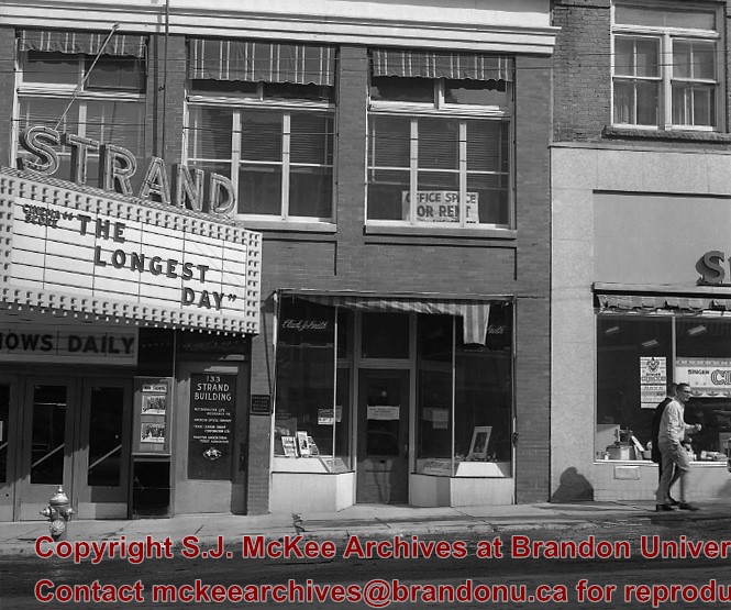
Scope and Content
Photograph shows an aerial view of the Medicine Hat Exhibition and Stampede Parade route with a focus on the First Street SE. A number of gas stations and garages are visible along this route and include Texaco, Shell, Ford, and B/A. The Fraternal Order of Eagles lodge is also visible.
Notes
This photograph appeared on the front page of The Medicine Hat News (19 July 1962).
The Medicine Hat Exhibition and Stampede Parade Day was held on Thursday, July 19, 1962, at 9:30 a.m. The local newspaper reported that approximately 24,000 people were in attendance to see parade marshall Rod Ashburner leading 175 entries consisting of 90 floats, 75 horses, and 10 bands. There were 19 parade categories eligible for $12,000 in prize money and included: junior and senior cowboys and cowgirls; fancy and Shetland ponies; sulky class open; comic, commercial, industrial and organizational floats; decorated cars; special ranch class; 4-H Clubs; and a non-competitive class.
The parade route started at Second St. and Allowance Ave., from Second St. to Ash Ave., north on Ash to First St. SE., from First St. S.E. to Fourth Ave., south to Second St. to South Railway St., south on South Railway St. to Third St., with a finish at McLeod Trail. A route map was published in the Medicine Hat News the day before the parade.
Aerial photographs of the parade were taken by Medicine Hat News photographer Howard Heid (1930-2005) from the private helicopter of John Bourn. Bourn was a pilot from Woodville, Wisconsin, who chartered his four-seater helicopter for sight-seers at exhibitions and stampedes across the county.
(Sources: Pat Currie, "Let 'Er Go!," Medicine Hat News, 19 July 1962,1; Harald Gunderson, "'Eye in the Sky' Best Parade View," Medicine Hat News, 19 July 1962,1; "Parade Starts at 9:30 Sharp," 18 July 1962)
Scope and Content
Photograph shows an aerial view of the Medicine Hat Exhibition and Stampede Parade route with a focus on the First Street SE and and the South Railway Street merge. A number of gas stations and garages are visible along this route and include Texaco, Shell, Ford, and B/A. The Fraternal Order of Eagles lodge is also visible.
Notes
This photograph shows the neighbourhood before rezoning and commercial development.


