Skip header and navigation

Revise Search

20 records – page 11 of 1.

Medicine Hat Exhibition and Stampede - Parade Day 10

http://archives.brandonu.ca/en/permalink/descriptions14151
Part Of
Fred McGuinness collection
Description Level
Item
GMD
graphic
Date Range
1962
Accession Number
1-2015
Part Of
Fred McGuinness collection
Creator
Photographer: Howard Heid, Medicine Hat News
Description Level
Item
Series Number
McG 9
Item Number
1-2015.220
Accession Number
1-2015
GMD
graphic
Date Range
1962
Physical Description
10" x 8" (b/w)
History / Biographical
The Medicine Hat Exhibition and Stampede Parade Day was held on Thursday, July 19, 1962, at 9:30 a.m. The local newspaper reported that approximately 24,000 people were in attendance to see parade marshall Rod Ashburner leading 175 entries consisting of 90 floats, 75 horses, and 10 bands. There were 19 parade categories eligible for $12,000 in prize money and included: junior and senior cowboys and cowgirls; fancy and Shetland ponies; sulky class open; comic, commercial, industrial and organizational floats; decorated cars; special ranch class; 4-H Clubs; and a non-competitive class. The parade route started at Second St. and Allowance Ave., from Second St. to Ash Ave., north on Ash to First St. SE., from First St. S.E. to Fourth Ave., south to Second St. to South Railway St., south on South Railway St. to Third St., with a finish at McLeod Trail. A route map was published in the Medicine Hat News the day before the parade. Aerial photographs of the parade were taken by Medicine Hat News photographer Howard Heid (1930-2005) from the private helicopter of John Bourn. Bourn was a pilot from Woodville, Wisconsin, who chartered his four-seater helicopter for sight-seers at exhibitions and stampedes across the county. (Sources: Pat Currie, "Let 'Er Go!," Medicine Hat News, 19 July 1962,1; Harald Gunderson, "'Eye in the Sky' Best Parade View," Medicine Hat News, 19 July 1962,1; "Parade Starts at 9:30 Sharp," 18 July 1962)
Scope and Content
Photograph shows an aerial view of the Medicine Hat Exhibition and Stampede Parade route with a focus west of the railway allowance, showing First Street SE, Second Street SE, and Third Street SE.
Notes
This photograph shows the neighbourhood before rezoning and commercial development.
Name Access
Medicine Hat
South Saskatchewan River
Subject Access
parades
floats
aerial photography
aerial views
street scenes
gardens
Repro Restriction
Subject to Canadian Copyright Law
Storage Location
RG 5 photograph storage drawer 2 (hanging photos)
Arrangement
BR #3 Family photos
Images
Show Less

Medicine Hat Exhibition and Stampede - Parade Day 11

http://archives.brandonu.ca/en/permalink/descriptions14152
Part Of
Fred McGuinness collection
Description Level
Item
GMD
graphic
Date Range
1962
Accession Number
1-2015
Part Of
Fred McGuinness collection
Creator
Photographer: Howard Heid, Medicine Hat News
Description Level
Item
Series Number
McG 9
Item Number
1-2015.221
Accession Number
1-2015
GMD
graphic
Date Range
1962
Physical Description
10" x 8" (b/w)
History / Biographical
The Medicine Hat Exhibition and Stampede Parade Day was held on Thursday, July 19, 1962, at 9:30 a.m. The local newspaper reported that approximately 24,000 people were in attendance to see parade marshall Rod Ashburner leading 175 entries consisting of 90 floats, 75 horses, and 10 bands. There were 19 parade categories eligible for $12,000 in prize money and included: junior and senior cowboys and cowgirls; fancy and Shetland ponies; sulky class open; comic, commercial, industrial and organizational floats; decorated cars; special ranch class; 4-H Clubs; and a non-competitive class. The parade route started at Second St. and Allowance Ave., from Second St. to Ash Ave., north on Ash to First St. SE., from First St. S.E. to Fourth Ave., south to Second St. to South Railway St., south on South Railway St. to Third St., with a finish at McLeod Trail. A route map was published in the Medicine Hat News the day before the parade. Aerial photographs of the parade were taken by Medicine Hat News photographer Howard Heid (1930-2005) from the private helicopter of John Bourn. Bourn was a pilot from Woodville, Wisconsin, who chartered his four-seater helicopter for sight-seers at exhibitions and stampedes across the county. (Sources: Pat Currie, "Let 'Er Go!," Medicine Hat News, 19 July 1962,1; Harald Gunderson, "'Eye in the Sky' Best Parade View," Medicine Hat News, 19 July 1962,1; "Parade Starts at 9:30 Sharp," 18 July 1962)
Scope and Content
Photograph shows an aerial view of possibly 8th Street NW and Tweed Avenue NW. A Safeway grocery store, park and residential area are visible. Many of hte homes appear to have gardens.
Notes
This photograph shows the neighbourhood before rezoning and commercial development.
Name Access
Medicine Hat
South Saskatchewan River
Subject Access
parades
floats
aerial photography
aerial views
street scenes
gardens
Repro Restriction
Subject to Canadian Copyright Law
Storage Location
RG 5 photograph storage drawer 2 (hanging photos)
Arrangement
BR #3 Family photos
Images
Show Less

Aerial view: Brandon University campus

http://archives.brandonu.ca/en/permalink/descriptions2576
Part Of
Brandon University Photograph Collection
Description Level
Item
GMD
graphic
Date Range
September 21, 1999
Part Of
Brandon University Photograph Collection
Description Level
Item
Series Number
9
Item Number
BUPC 9.36
GMD
graphic
Date Range
September 21, 1999
Physical Description
11" x 14" (colour)
History / Biographical
The photograph was taken for the Centennial of Brandon College/University.
Scope and Content
Aerial photograph taken looking southwest from approximately the northeast corner of Princess Avenue and 17th Street. The entire campus, as well as a number of residential streets are visible.
Notes
Negative is located with the photograph
Subject Access
campus buildings
aerial photographs
aerial photography
aerial views
cityscapes
Storage Range
Oversized drawer 4
Images
Show Less

Duthie site DiMe-16

http://archives.brandonu.ca/en/permalink/descriptions10216
Part Of
RG 7 Beverley Nicholson fonds
Description Level
Sub-series
GMD
multiple media
Date Range
1992-2002
Accession Number
1-2010
Part Of
RG 7 Beverley Nicholson fonds
Description Level
Sub-series
Series Number
4.1
Accession Number
1-2010
GMD
multiple media
Date Range
1992-2002
History / Biographical
The Duthie site is the first site identified in the Makotchi-Ded Dontipi locale. It was reported to Dr. Bev Nicholson by Doug Jackson, a local collector who had observed archaeological materials that had been exposed during the construction of Maple Hill Road northwest of Lauder. The site is named after the landowner, Randy Duthie. The initial inspection of the exposed materials indicated that the eastern half of the site had been severely impacted by raising a road grade using an elevating grader. However, an undetermined amount of the site remained to the west, flanked by a low sand dune. Testing and preliminary excavations were conducted in 1992-93. In 1994 a field school added to the excavated sample. The undisturbed portion of the site, west of Maple Hill Road was situated at the base of a low sand dune and had an aspen and willow forest cover. The water table was approximately one meter below surface at the time of excavation. A rising water table has since prevented further excavations. Two dates on bone collagen were obtained during excavations. These were 880+/-80 B.P. (Beta 62705) and 970+/-40 B.P. cal. 1030 A.D. (TO 13366). These dates are consistent with an Initial Middle Missouri cultural assignment. The site occupation is identified by the distinctive ceramics found there. Ceramics at the Duthie Site are tool impressed with incising and lip modeling with fabric impressions on most vessels. Jill Taylor analysed the ceramics from the site for a Specialist thesis, Brandon University (1994) and a Masters of Arts degree from the University of Saskatchewan. (Taylor 1995). Analysis of residue from Duthie site pottery by Matthew Boyd recovered corn (Zea mays) phytoliths and bean (Phaseolus sp.) starch grains indicating consumption of these domesticates at the Duthie site. (Boyd 2006) The occupation of this site indicates a migration of people from the south who were well acquainted with horticultural farming. These people had previously migrated to South Dakota following river valleys into the central plains from the eastern woodlands during late Hopewell times. It appears that they later migrated well to the north into southern Manitoba but there is no evidence that they remained there for more than a single year. Boyd, M., C. Surette and B.A. Nicholson. 2006 Archaeobotanical Evidence of Prehistoric Maize (Zea mays) Consumption at the Northern Edge of the Great Plains. Journal of Archaeological Science 33: 1129-1140. Taylor, J. 1994 An analysis of the ceramics recovered during 1992 and 1993 at the Precontact Duthie Site (DiMe-16). Specialist thesis, Brandon University.
Scope and Content
The Series has been divided into seven sub-series, including (1) Duthie site (2) Jackson site (3) Twin Fawns site (4) Vera site (5) Schuddemat site (6) Bradshaw site (7) Hollow B site.
Name Access
Duthie site DiMe-16
Subject Access
Archaeology Makotchi-Ded Dontipi locale Duthie site DiMe-16
Show Less

McGuinness Medicine Hat residence - aerial

http://archives.brandonu.ca/en/permalink/descriptions14115
Part Of
Fred McGuinness collection
Description Level
Item
GMD
graphic
Date Range
[1960-1965]
Accession Number
1-2015
Part Of
Fred McGuinness collection
Description Level
Item
Series Number
McG 9
Item Number
1-2015.184
Accession Number
1-2015
GMD
graphic
Date Range
[1960-1965]
Physical Description
10" x 8" (b/w)
Scope and Content
Photograph shows the construction of the McGuinness home in a new housing development in Medicine Hat, 492 6th Street Northeast. Aerial view shows that neighbouring blocks have yet to be constructed.
Name Access
Fred McGuinness
Frederick George McGuinness
Medicine Hat
Subject Access
residences
street scenes
residential streets
winter
aerial views
aerial photography
Storage Location
RG 5 photograph storage drawer 2 (hanging photos)
Arrangement
BR #3 Family photos
Images
Show Less

McGuinness Medicine Hat residence - winter aerial

http://archives.brandonu.ca/en/permalink/descriptions14116
Part Of
Fred McGuinness collection
Description Level
Item
GMD
graphic
Date Range
[1960-1965]
Accession Number
1-2015
Part Of
Fred McGuinness collection
Description Level
Item
Series Number
McG 9
Item Number
1-2015.185
Accession Number
1-2015
GMD
graphic
Date Range
[1960-1965]
Physical Description
10" x 8" (b/w)
Scope and Content
Photograph shows the McGuinness home in a new housing development in Medicine Hat, 492 6th Street Northeast. Aerial view shows that neighbouring blocks have yet to be constructed and the backyard to the McGuinness home is completed.
Name Access
Fred McGuinness
Frederick George McGuinness
Medicine Hat
Subject Access
residences
street scenes
residential streets
winter
aerial views
aerial photography
Storage Location
RG 5 photograph storage drawer 2 (hanging photos)
Arrangement
BR #3 Family photos
Images
Show Less

Clark Smith Studio

http://archives.brandonu.ca/en/permalink/descriptions9543
Part Of
RG 11 Lawrence Stuckey fonds
Description Level
Item
GMD
graphic
Date Range
April 1964
Accession Number
1-2002
Part Of
RG 11 Lawrence Stuckey fonds
Creator
L.A. Stuckey
Description Level
Item
Series Number
3.1
Item Number
1-2002.3.1EA9
Accession Number
1-2002
GMD
graphic
Date Range
April 1964
Physical Description
2 1/2" x 2 1/2"
Material Details
Negative
History / Biographical
Located at 133 10th Street, the Clark Smith Studio was taken over from Clark J. Smith by L.A. Stuckey on January 1, 1958.
Custodial History
For custodial history see the collection level description of the Lawrence Stuckey collection.
Scope and Content
Clark Smith Studio.
Name Access
Clark Smith Studio
Strand Theatre
Subject Access
businesses
photography studios
cinemas
Brandon business buildings & facilities after 1940
Repro Restriction
The McKee Archives is the copyright holder for the Stuckey materials.
Storage Location
Lawrence Stuckey collection
Arrangement
[Mr. Stuckey put two negatives in same envelope, numbered EA9 and EA9a. We have separated them.]
Images
Show Less

Clark Smith Studio

http://archives.brandonu.ca/en/permalink/descriptions9545
Part Of
RG 11 Lawrence Stuckey fonds
Description Level
Item
GMD
graphic
Date Range
April 1964
Accession Number
1-2002
Part Of
RG 11 Lawrence Stuckey fonds
Creator
L.A. Stuckey
Description Level
Item
Series Number
3.1
Item Number
1-2002.3.1EA9a
Accession Number
1-2002
GMD
graphic
Date Range
April 1964
Physical Description
2 1/2" x 2 1/2"
Material Details
Negative
Custodial History
For custodial history see the collection level description of the Lawrence Stuckey collection.
Scope and Content
Clark Smith Studio
Strand Theatre
Notes
Located at 133 Tenth Street
View of construction housing while rebuilding front of studio in summer of 1964.
[Mr. Stuckey put two negatives in same envelope, numbered EA9 and EA9a. We have separated them.]
Name Access
Clark Smith Studio
Strand Theatre
Subject Access
businesses
photography studios
cinemas
Brandon business buildings & facilities after 1940
Repro Restriction
The McKee Archives is the copyright holder for the Stuckey materials.
Storage Location
Lawrence Stuckey collection
Images
Show Less

Crepeele site 2003

http://archives.brandonu.ca/en/permalink/descriptions11707
Part Of
RG 7 Beverley Nicholson fonds
Description Level
Sub sub series
GMD
multiple media
Date Range
2003
Accession Number
1-2010
Part Of
RG 7 Beverley Nicholson fonds
Description Level
Sub sub series
Series Number
1.2.1
Accession Number
1-2010
GMD
multiple media
Date Range
2003
Material Details
Field journals have been scanned in multi-page PDF files. Artifact catalogues are PDF files in spreadsheet format. Photographs are in jpeg format.
History / Biographical
The Crepeele site was identified from the results of the Casselman survey. The site is located within the Crepeele locale approximately 400 meters to the west of the Sarah site. The units were excavated by Crew Chief James Graham and the crew from the survey. The Crepeele site was excavated in 2003 as Crepeele 3 with the units numbered as units 10, 11, 12 & 13. These numbers have been changed on the catalogue to XU 110 – 113, due to duplication in 2005. Corresponding documents have been changed but there may be some reference to the initial numbers in the field journals. The artifacts recovered from these four excavations are faunal (animal bone), mainly bison, lithic materials (stone tools and flakes) and some ceramic (pottery). The artifact catalogue has over 600 records.
Scope and Content
Sub-sub-sub series contains: Summary information of field methology, number and co-ordinates of excavations, personnel and their staff position; Field journalsare daily records of recoveries, features and activities at the site; Site records include excavation level and unit summaries, feature sheets, profiles; sample records and maps; Artifact catalogues are lists and identifications of all artifacts recovered; Photographs are of excavation units, features, the landscape and personnel.
Name Access
Crepeele site 2003
Subject Access
Archaeology Crepeele locale Crepeele site DiMe-29 Crepeele site 2003
Show Less

Crepeele site 2003 - James Graham field journal

http://archives.brandonu.ca/en/permalink/descriptions11708
Part Of
RG 7 Beverley Nicholson fonds
Description Level
File
GMD
textual records
Date Range
2003
Accession Number
1-2010
Part Of
RG 7 Beverley Nicholson fonds
Description Level
File
Series Number
1.2.1.2
File Number
1
Accession Number
1-2010
GMD
textual records
Date Range
2003
Physical Description
47-71 pp.
Material Details
PDF
Scope and Content
Record of excavation methods, items recovered, features, local environment and weather noted by crew chief.
Name Access
Crepeele site 2003 - James Graham
Subject Access
Archaeology Crepeele locale Crepeele site DiMe-29 Crepeele site 2003
Documents

1.2.1.2.1_C03_JG_FJ.pdf

Read PDF Download PDF
Show Less

Crepeele site 2003 - Sarah Graham field journal 2 of 2

http://archives.brandonu.ca/en/permalink/descriptions11709
Part Of
RG 7 Beverley Nicholson fonds
Description Level
File
GMD
textual records
Date Range
2003
Accession Number
1-2010
Part Of
RG 7 Beverley Nicholson fonds
Description Level
File
Series Number
1.2.1.2
File Number
3
Accession Number
1-2010
GMD
textual records
Date Range
2003
Physical Description
21 pp.
Material Details
PDF
Scope and Content
Field journal 2 of 2 by crew member Sarah Graham. Record of excavation methods, items recovered, features, local environment and weather.
Name Access
Crepeele site 2003 - Sarah Graham
Subject Access
Archaeology Crepeele locale Crepeele site DiMe-29 Crepeele site 2003
Documents

1.2.1.2.3_C03_SG_2of2.pdf

Read PDF Download PDF
Show Less

Crepeele site 2003 - site record XU 111

http://archives.brandonu.ca/en/permalink/descriptions11711
Part Of
RG 7 Beverley Nicholson fonds
Description Level
File
Accession Number
1-2010
Part Of
RG 7 Beverley Nicholson fonds
Description Level
File
Series Number
1.2.1.3
File Number
2
Accession Number
1-2010
Physical Description
20 pages
Material Details
PDF
History / Biographical
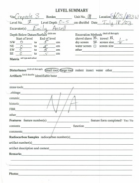
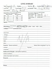
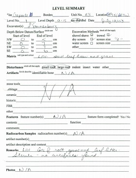
Record of excavation unit 111 at the Crepeele site 2003.
Scope and Content
Site excavation records of excavation units may include: level summaries, floor plans, feature sheets, wall profiles, unit summaries and any other additional information relating to the unit.
Name Access
Crepeele site 2003 - site record XU 111
Subject Access
Archaeology Crepeele locale
Crepeele site DiMe-29 Crepeele site 2003
Documents

1.2.1.3.2_ C03_XU111.pdf

Read PDF Download PDF
Show Less

Crepeele site 2003 - site record XU 112

http://archives.brandonu.ca/en/permalink/descriptions11712
Part Of
RG 7 Beverley Nicholson fonds
Description Level
File
Accession Number
1-2010
Part Of
RG 7 Beverley Nicholson fonds
Description Level
File
Series Number
1.2.1.3
File Number
3
Accession Number
1-2010
Physical Description
20 pages
Material Details
PDF
History / Biographical
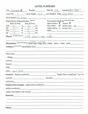
Record of site excavation unit 112 at the Crepeele site 2003.
Scope and Content
Site excavation records of excavation units may include: level summaries, floor plans, feature sheets, wall profiles, unit summaries and any other additional information relating to the unit.
Name Access
Crepeele site 2003 - site records
Subject Access
Archaeology Crepeele locale Crepeele site DiMe-29 Crepeele site 2003
Documents

1.2.1.3.3_C03_XU112.pdf

Read PDF Download PDF
Show Less

Crepeele site 2003 - site record XU 113

http://archives.brandonu.ca/en/permalink/descriptions11713
Part Of
RG 7 Beverley Nicholson fonds
Description Level
File
Accession Number
1-2010
Part Of
RG 7 Beverley Nicholson fonds
Description Level
File
Series Number
1.2.1.3
File Number
4
Accession Number
1-2010
Physical Description
18 pages
Material Details
PDF
History / Biographical
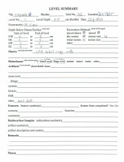
Record of site excavation unit 113 at the Crepeele site 2003.
Scope and Content
Site excavation records of excavation units may include: level summaries, floor plans, feature sheets, wall profiles, unit summaries and any other additional information relating to the unit.
Name Access
Crepeele site 2003 - site record
Subject Access
Archaeology Crepeele locale Crepeele site DiMe-29 Crepeele site 2003
Documents

1.2.1.3.4_C03_XU113.pdf

Read PDF Download PDF
Show Less

Crepeele site 2003 - photographs

http://archives.brandonu.ca/en/permalink/descriptions11714
Part Of
RG 7 Beverley Nicholson fonds
Description Level
sub sub sub series
GMD
graphic
Date Range
2003
Accession Number
1-2010
Part Of
RG 7 Beverley Nicholson fonds
Description Level
sub sub sub series
Series Number
1.2.1.5
Accession Number
1-2010
GMD
graphic
Date Range
2003
Physical Description
5 photographs
Material Details
JPEGs
History / Biographical
Numerous photographs were taken during the excavation of the Crepeele site 2003. A selection of photographs of personnel performing usual field tasks such as surveying, measuring, excavating, and taking photographs were selected for the archive.
Scope and Content
Sub sub sub series consists of photographs taken during excavation of the Crepeele site 2003.
Name Access
Crepeele site 2003 - photographs
Subject Access
Archaeology Crepeele locale Crepeele site DiMe-29 Crepeele site 2003
Show Less

Crepeele site 2003 - site records

http://archives.brandonu.ca/en/permalink/descriptions11715
Part Of
RG 7 Beverley Nicholson fonds
Description Level
sub sub sub series
GMD
multiple media
Date Range
2003
Accession Number
1-2010
Part Of
RG 7 Beverley Nicholson fonds
Description Level
sub sub sub series
Series Number
1.2.1.3
Accession Number
1-2010
GMD
multiple media
Date Range
2003
Material Details
Site records have been scanned in multi-page PDF files.
History / Biographical
The Crepeele site was excavated in 2003 as Crepeele 3. Standard archaeological methods were used to excavate the units. Site records of excavation units XU 110 – 113 are in seperate pdf files.
Scope and Content
Site records of excavation units may include: level summaries, floor plans, feature sheets, wall profiles, unit summaries and any other additional information relating to the unit.
Name Access
Crepeele site 2003 - site records
Subject Access
Archaeology Crepeele locale Crepeele site DiMe-29 Crepeele site 2003
Show Less

Sarah site 2003 - summary information

http://archives.brandonu.ca/en/permalink/descriptions11720
Part Of
RG 7 Beverley Nicholson fonds
Description Level
sub sub sub series
GMD
multiple media
Date Range
2003
Accession Number
1-2010
{add= ARCH 1. Crepeele Locale 1.3 Sarah DiMe-28 1.3.1 Sarah 2003 1.3.1.1 Summary
Part Of
RG 7 Beverley Nicholson fonds
Description Level
sub sub sub series
Series Number
1.3.1.1
Accession Number
1-2010
GMD
multiple media
Date Range
2003
Material Details
Field journals have been scanned in multi-page PDF files. Artifact catalogues are PDF files in spreadsheet format. Photographs are in jpeg format.
History / Biographical
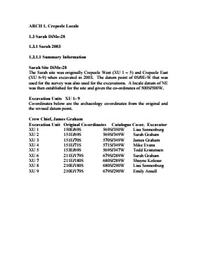
The Sarah site was initially chosen for excavation based on the results of the Casselman survey. The survey recovered significant amounts of faunal remains, some ceramics and lithics from the test pits. Excavations took place in 2003 at Crepeele West (Units 1-5) and Crepeele East (Units 6-9). The site was subsequently renamed the Sarah site DiMe-28. Units 1 to 9 were excavated by supervisor James Graham and crew of Sarah Graham, Mike Evans, Todd Kristensen, Shayne Kolesar, Lisa Sonnenburg and Emily Ansell.
Scope and Content
Sub-sub-sub series contains: Summary information of field methology, number and co-ordinates of excavations, personnel and their staff position.
Name Access
Sarah site 2003 - summary information
Subject Access
Archaeology Crepeele locale Sarah site DiMe-28 Sarah site 2003
Documents

1.3.1.1_ Sarah03_summary.pdf

Read PDF Download PDF
Show Less

Crepeele site 2004

http://archives.brandonu.ca/en/permalink/descriptions11725
Part Of
RG 7 Beverley Nicholson fonds
Description Level
Sub sub series
GMD
multiple media
Date Range
2004
Accession Number
1-2010
Part Of
RG 7 Beverley Nicholson fonds
Description Level
Sub sub series
Series Number
1.2.2
Accession Number
1-2010
GMD
multiple media
Date Range
2004
Material Details
Field journals have been scanned in multi-page PDF files. Artifact catalogues are PDF files in spreadsheet format. Photographs are in jpeg format.
History / Biographical
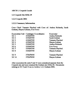
The Crepeele site was identified from the results of the Casselman survey and excavated in 2003. In 2004 the site was funded through the SCAPE project, directed by Bev Nicholson. The units were excavated by Crew Chief Tomasin Playford and crew. Eight units were excavated in 2004, XU 1to XU 8 The artifacts recovered from these eight excavations are faunal (animal bone), mainly bison, lithic materials (stone tools and flakes) and some ceramic (pottery). The artifact catalogue has 1258 records.
Scope and Content
Sub-sub-sub series contains: Summary information of field methology, number and co-ordinates of excavations, personnel and their staff position; Field journalsare daily records of recoveries, features and activities at the site; Site records include excavation level and unit summaries, feature sheets, profiles; sample records and maps; Artifact catalogues are lists and identifications of all artifacts recovered; Photographs are of excavation units, features, the landscape and personnel.
Name Access
Crepeele site 2004
Subject Access
Archaeology Crepeele locale Crepeele site DiMe-29 Crepeele site 2004
Show Less

Crepeele site 2004 - summary information

http://archives.brandonu.ca/en/permalink/descriptions11726
Part Of
RG 7 Beverley Nicholson fonds
Description Level
sub sub sub series
GMD
multiple media
Date Range
2004
Accession Number
1-2010
{add= ARCH 1. Crepeele Locale 1.2 Crepeele Site DiMe 29 1.2.2 Crepeele 2004 1.2.2.1
Part Of
RG 7 Beverley Nicholson fonds
Description Level
sub sub sub series
Series Number
1.2.2.1
Accession Number
1-2010
GMD
multiple media
Date Range
2004
Material Details
Field journals have been scanned in multi-page PDF files. Artifact catalogues are PDF files in spreadsheet format. Photographs are in jpeg format.
History / Biographical
The Crepeele site was identified from the results of the Casselman survey and excavated in 2003. Further units 1 to 8 were excavated in 2004. Funding was through the SCAPE project, directed by Dr. Bev Nicholson. The site was excavated by Crew Chief Tomasin Playford and crew.
Scope and Content
Sub-sub-sub series contains: Summary information of field methology, number and co-ordinates of excavations, personnel and their staff position.
Name Access
Crepeele site 2004 - summary information
Subject Access
Archaeology Crepeele locale Crepeele site DiMe-29 Crepeele site 2004
Documents

1.2.2.1_C04_Summary.pdf

Read PDF Download PDF
Show Less

Crepeele site 2005 - field journals

http://archives.brandonu.ca/en/permalink/descriptions11727
Part Of
RG 7 Beverley Nicholson fonds
Description Level
sub sub sub series
GMD
multiple media
Date Range
2005
Accession Number
1-2010
Part Of
RG 7 Beverley Nicholson fonds
Description Level
sub sub sub series
Series Number
1.2.3.2
Accession Number
1-2010
GMD
multiple media
Date Range
2005
Material Details
Field journals have been scanned in multi-page PDF files.
History / Biographical
In 2005 the Brandon University Field School was held at both the Crepeele and Graham sites in the Crepeele locale. At the Crepeele site nine units were excavated (XU10-16 & 20, 21). Units 20 & 21 were referred to as Meadow in the notes but are considered part of the larger site based on recoveries. Denise Ens instructed the school and James Graham was teaching assistant. Field journals were kept by both instructors.
Scope and Content
Record of daily observations at the site including: excavation methods, items recovered, features, local environment and weather.
Name Access
Crepeele site 2005 - field journals
Subject Access
Archaeology Crepeele locale Crepeele site DiMe-29 Crepeele site 2005
Show Less

20 records – page 11 of 1.