Field journals have been scanned in multi-page PDF files.
History / Biographical
The Crepeele site was excavated in 2003 as Crepeele 3. Standard archaeological methods were used to excavate the units. Excavation units were initially numbered as units 10, 11, 12 & 13. These numbers have been changed on the catalogue to XU 110 – 113, due to duplication in 2005. Corresponding documents have been changed to reflect the amended excavation unit numbers, however the field journals may contain the initial numbers.
Scope and Content
Record of daily observations at the site including: excavation methods, items recovered, features, local environment and weather.
The Duthie site is the first site identified in the Makotchi-Ded Dontipi locale. It was reported to Dr. Bev Nicholson by Doug Jackson, a local collector who had observed archaeological materials that had been exposed during the construction of Maple Hill Road northwest of Lauder. The site is named after the landowner, Randy Duthie.
The initial inspection of the exposed materials indicated that the eastern half of the site had been severely impacted by raising a road grade using an elevating grader. However, an undetermined amount of the site remained to the west, flanked by a low sand dune. Testing and preliminary excavations were conducted in 1992-93. In 1994 a field school added to the excavated sample. The undisturbed portion of the site, west of Maple Hill Road was situated at the base of a low sand dune and had an aspen and willow forest cover. The water table was approximately one meter below surface at the time of excavation. A rising water table has since prevented further excavations.
Two dates on bone collagen were obtained during excavations. These were 880+/-80 B.P. (Beta 62705) and 970+/-40 B.P. cal. 1030 A.D. (TO 13366). These dates are consistent with an Initial Middle Missouri cultural assignment. The site occupation is identified by the distinctive ceramics found there. Ceramics at the Duthie Site are tool impressed with incising and lip modeling with fabric impressions on most vessels. Jill Taylor analysed the ceramics from the site for a Specialist thesis, Brandon University (1994) and a Masters of Arts degree from the University of Saskatchewan. (Taylor 1995).
Analysis of residue from Duthie site pottery by Matthew Boyd recovered corn (Zea mays) phytoliths and bean (Phaseolus sp.) starch grains indicating consumption of these domesticates at the Duthie site. (Boyd 2006)
The occupation of this site indicates a migration of people from the south who were well acquainted with horticultural farming. These people had previously migrated to South Dakota following river valleys into the central plains from the eastern woodlands during late Hopewell times. It appears that they later migrated well to the north into southern Manitoba but there is no evidence that they remained there for more than a single year.
Boyd, M., C. Surette and B.A. Nicholson. 2006 Archaeobotanical Evidence of Prehistoric Maize (Zea mays) Consumption at the Northern Edge of the Great Plains. Journal of Archaeological Science 33: 1129-1140.
Taylor, J. 1994 An analysis of the ceramics recovered during 1992 and 1993 at the Precontact Duthie Site (DiMe-16). Specialist thesis, Brandon University.
Scope and Content
The Series has been divided into seven sub-series, including (1) Duthie site (2) Jackson site (3) Twin Fawns site (4) Vera site (5) Schuddemat site (6) Bradshaw site (7) Hollow B site.
Field journals have been scanned in multi-page PDF files. Artifact catalogues are PDF files in spreadsheet format. Photographs are in jpeg format.
History / Biographical
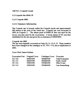
The Crepeele site was identified from the results of the Casselman survey. The site is located within the Crepeele locale approximately 400 meters to the west of the Sarah site. The units were excavated by Crew Chief James Graham and the crew from the survey.
The Crepeele site was excavated in 2003 as Crepeele 3 with the units numbered as units 10, 11, 12 & 13. These numbers have been changed on the catalogue to XU 110 – 113, due to duplication in 2005. Corresponding documents have been changed but there may be some reference to the initial numbers in the field journals.
The artifacts recovered from these four excavations are faunal (animal bone), mainly bison, lithic materials (stone tools and flakes) and some ceramic (pottery). The artifact catalogue has over 600 records.
Scope and Content
Sub-sub-sub series contains: Summary information of field methology, number and co-ordinates of excavations, personnel and their staff position; Field journalsare daily records of recoveries, features and activities at the site; Site records include excavation level and unit summaries, feature sheets, profiles; sample records and maps; Artifact catalogues are lists and identifications of all artifacts recovered; Photographs are of excavation units, features, the landscape and personnel.
Field journals have been scanned in multi-page PDF files.
History / Biographical
The Sarah site was chosen for excavation based on the results of the Casselman survey. The survey recovered significant amounts of faunal remains, some ceramics and lithics from the test pits. Excavations took place in 2003 at Crepeele West (Units 1-5) and Crepeele East (Units 6-9). The site was subsequently renamed the Sarah site DiMe-28.
Field journals from 2003 contain notes concerning the Casselman survey, Crepeele and Sarah site.
Scope and Content
Record of daily observations at the site including: excavation methods, items recovered, features, local environment and weather.
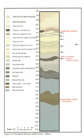
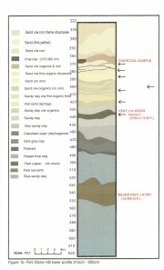
Flintstone Hill is located on the north bank of the Souris River. It is a deeply stratified lacustrine, fluvial and aeolian soil profile that has been exposed by the river through stream-bank erosion. This section is thought to be the most complete middle to late Holocene exposure on the northeastern plains. While the value of the site is primarily for paleo-environmental research and reconstruction, cultural deposits have been identified at the site. Local collectors have picked up lithic materials as they eroded out of the bank for the past several decades and it was they who had named the site. Mr. Bruce Timms from Lauder first drew the Flintstone Hill site to the attention of Dr. Nicholson of Brandon University.
During the mid 1990’s to the early 2000’s archaeological testing took place on Flintstone Hill. In 1998, an archaeological field crew dug a series of overlapping trenches down the slope of the profile and produced a schematic drawing. A peat layer at the bottom of this profile, dated from the top at 9,400 RCY and at the bottom to 10,400 RCY, has provided details of marsh plant and insect communities at this time.
Subsequent archaeological investigations at the site recovered several cultural deposits including: a hearth dating to 3250+/-70 R.C.Y. (BETA 109529); a butchered atlas bone 4090+/-70 R.C.Y. (BETA 109990); and bone fragments accompanied by Swan River Chert and Knife River Flint lithic flakes 5350+/-50 (BETA 109530). While no diagnostic tools were recovered, these dates suggest that this occupation, which is contemporary with the Atkinson site, may be a Gowen occupation.
Extensive paleo-environmental research has been conducted at the site. Dr. Running, a geomorphologist from the University of Wisconsin – Eau Claire, participated in the Study of Cultural Adaptations in the Prairie Ecozone (SCAPE) Project and he and his students tested the site for several years. He was joined in this effort by Dr. Havholm, Dr. Boyd, Dr. Wiseman, Dr. Beaudoin, and other SCAPE researchers in the interpretation of the paleo-environment of the Glacial Lake Hind basin. The following article is recommended reading.
Running, Garry L., Karen G. Havholm, Matt Boyd and Dion J. Wiseman
2002 Holocene Stratigraphy and Geomorphology of Flintstone Hill, Lauder Sandhills, Glacial Lake Hind Basin, Southwestern Manitoba. Geographie Physique et Quaternaire
56(2-3):291-303.
Scope and Content
Sub series has been divided into two sub sub series including: (1) Flintstone Hill 1997 (2) Flintstone Hill 1998-2000
Field journals have been scanned in multi-page PDF files. Artifact catalogues are PDF files in spreadsheet format. Photographs are in jpeg format.
History / Biographical
During the mid 1990’s to the early 2000’s archaeological surveying and testing took place on Flintstone Hill. In 1997 testing at the site revealed a bison skull eroding from the cutbank. A field crew dug a series of overlapping trenches down the slope of the profile and produced a schematic drawing. A radiocarbon date from the lower edge of the profile gave a date of 10,400 RCY.
Test units along the cutbank recovered lithics, soil samples, fire-cracked rock, charcoal, bison remains including a very large bison skull measuring 430-440 cm and thought to be an ancient species.
Radiocarbon dates at Flintstone hill gave dates of: a hearth dating to 3250+/-70 R.C.Y. (BETA 109529); a butchered atlas bone 4090+/-70 R.C.Y. (BETA 109990); and bone fragments accompanied by Swan River Chert and Knife River Flint lithic flakes 5350+/-50 (BETA 109530). While no diagnostic tools were recovered, these dates suggest that this occupation, which is contemporary with the Atkinson site, may be a Gowen occupation.
Scope and Content
Sub-sub-sub series contains: Summary information of field methology, number and co-ordinates of excavations, personnel and their staff position; Field journals are daily records of recoveries, features and activities at the site; Site records include excavation level and unit summaries, feature sheets, profiles; sample records and maps; Artifact catalogues are lists and identifications of all artifacts recovered; Photographs are of excavation units, features, the landscape and personnel.
Field journals have been scanned in multi-page PDF files. Artifact catalogues are PDF files in spreadsheet format. Photographs are in jpeg format.
History / Biographical
In 1998, 1999 and 2000 further testing took place on Flintstone Hill. Five test units were excavated and a series of small exploratory tests took place. Recoveries included: lithics, soil samples, fire-cracked rock, charcoal, and bison bones.
Unfortunately, despite the encouraging radiocarbon dates and scattered recoveries there was no area where extensive excavations were feasible. The unstable nature of the river bank with frequent spring flooding and erosion of the dunes has impacted potential sites.
Scope and Content
Sub-sub-sub series contains: Summary information of field methology, number and co-ordinates of excavations, personnel and their staff position; Field journals are daily records of recoveries, features and activities at the site; Site records include excavation level and unit summaries, feature sheets, profiles; sample records and maps; Artifact catalogues are lists and identifications of all artifacts recovered; Photographs are of excavation units, features, the landscape and personnel.
The Brandon College Students series is an artificially created collection. It contains the private papers of former Brandon College students.
Scope and Content
The series has been divided into the following sub-series:
MG 2 2.1 Kathleen Emily Kenner
MG 2 2.2 Gerald R. Brown
MG 2 2.3 Saul L. Cohen
MG 2 2.4 Paul McKinnon
MG 2 2.5 Verda McDonald
MG 2 2.6 Frances Percival (nee Fraser)
MG 2 2.7 Raymond R. Bailey
MG 2 2.8 Harold Arthur Kinniburgh
MG 2 2.9 Barbara Cooper
MG 2 2.10 Class of 1953
MG 2 2.11 Elizabeth Kovach
MG 2 2.12 Carole Paintin-Dence
MG 2 2.13 Edward Lloyd Bowler
MG 2 2.14 Rev. Einar Egilsson
MG 2 2.15 George Thorman
MG 2 2.16 Robert Dudley Howland
MG 2 2.17 Charles H. Koester
MG 2 2.18 Robert Harvey
MG 2 2.19 Lawrence Skeoch
MG 2 2.20 Edith Laycock
MG 2 2.21 Marion Stone
MG 2 2.22 Margaret Doran Roberts
MG 2 2.23 Georgina (Hill) Matiation
MG 2 2.24 Class of 1950
MG 2 2.25 Donald Freeman
MG 2 2.26 William Archibald Branton
MG 2 2.27 Adelene Monica Bailey
MG 2 2.28 Lois and Gordon Daly
MG 2 2.29 Marionne Scott
MG 2 2.30 Christine Coltart
MG 2 2.31 Bertha Leith (nee Clark)
MG 2 2.32 Margaret Hawley Speers
MG 2 2.33 Ruth and Archie MacLachlan
MG 2 2.34 Fran Sallows
MG 2 2.35 Clare Coburn
MG 2 2.36 Gordon Lindsay
File consists of a request for approval in principle and a request for final approval for financial assistance for special capital project to the Universities Grants Commission, correspondence, notes and a blueprint.
Storage Location
RG 6 Brandon University fonds
Series 2: Board of Governors
2.6 Board Projects
Box 1
The Board of Governors of Brandon University is a body established by the Brandon University Act (1998), a statute of the Province of Manitoba. The Act vests in the Board the authority for governing Brandon University. The members of the Board of Governors, as trustees, hold the University in trust for the people of the Province of Manitoba. Responsibilities for maintaining this trust include: selection of a president, monitoring his/her performance, providing guidance to the University via its policies, and often delegating authority to the administration.
The Board of Governors is a collective representing the entire community (both internal and external of the University). As a collective, the Board of Governors is responsible for ensuring the financial stability of the institution and for seeing that the overall plans of the institution are consistent with the institution’s philosophy, goals, and financial resources.
Scope and Content
Fonds consists of records generated and collected by the Brandon University Board of Governors in the course of perfoming its functions. The fonds is divided into six sub-series, incuding: (1) Documents; (2) Board Executive; (3) General Board agendas, minutes and packages; (4) Correspondence and subject files; (5) Board of Governors' committees; and (6) Board projects.
Notes
The information in the History/Bio field was taken from the Brandon University webpage (http://www.brandonu.ca/Administration/Governors/) on December 2, 2005.
Access Restriction
All files in the series are restricted. Researchers are required to contact the Executive Secretary to the Board of Governors to obtain written permission to access the records. Contact:
204-727-9714
board@brandonu.ca
9.46 m textual records; 1919 photographs & graphics
History / Biographical
Brandon, Manitoba was incorporated as a city in 1881. In 1882, led by Charles Whitehead and a small Board of Directors that included J.W. Vantassel, Charles Pilling, George Halse, J.E. Smith, William Johnson, R.T. Evans, and Thomas Lockhart, it was decided to hold an agricultural exhibition. These men were all involved in the farm business in one way or another, and they wanted an opportunity to help residents realize the agricultural potential of the region. In October of that year, the fledgling community held its first agricultural exhibition . The fair was held in downtown Brandon at what was known as “Market Square.” Market Square was two acres of land located on Princess Avenue between Eighth and Ninth Streets. Due to poor weather, and the fact that not many people were ready to show animals and grain, there was a relatively small turnout. The following year was much improved. There were 730 entries into the exhibition. By 1884, the Board of Directors of the Brandon Agricultural Society, which was in charge of the exhibition, realized that they were in poor financial shape, to the point of being personally out of pocket. It was realized that October was not the best time for farmers to be leaving their farms to go to an exhibition. In 1888, it was decided to move the exhibition to the summer time, when it was much easier for people to attend.
The first Brandon Summer Fair was held in July 1889, and it was a resounding success. The Board of Directors had added many items of interest to appeal to the entire public, not just agricultural people. In 1892, the Western Agricultural and Arts Association (WAAA) was formally established to take over duties from the Brandon Agricultural Society. However, it was not until 1897 that the WAAA held its first meeting. There is no explanation as to why there is a five year gap between the formation and the first meeting of this organization. 1897 was the turning point of the Brandon Exhibition. The fair was now firmly established in Brandon, and the Board of Directors was instrumental in ensuring that it remained so. This was done by petitioning to both the municipal and provincial governments for grant money. As well, the Board booked midway and grandstand acts that would bring the city dwellers to the agricultural exhibition.
There were also early attempts at holding an agricultural exhibition in the winter. The first such attempt was in 1884. There was also a Spring Stallion show held in 1891. By 1904, however, a petition by J.D. McGregor had gone out to formally establish a winter exhibition. This effort also failed, but by 1906, it was decided by businessmen, politicians, and farm representatives in Brandon, including McGregor, to organize a winter fair. Rather than seeing this new fair as competition, the Board of Directors of the summer fair felt that it would complement their exhibition. The new fair would remain primarily agricultural. The first winter fair was held in 1906. While the two fairs were not amalgamated, they did share the same secretary-manager. The secretary-manager was responsible for the day to day management of the fair, as well as keeping track of meetings and decisions reached by the various fair boards and committees. In 1907, the Brandon Winter Fair and Livestock Association (BWFLA) was formed to act primarily as a land-holding joint stock company. The following year the Provincial Winter Fair and Fat Stock Association (PWFFSA), an entirely separate organization from the BWFLA, was formed to manage the activities of the winter fair. The PWFFSA name was soon changed to the Manitoba Winter Fair and Fat Stock Association (MWFFSA).
By 1906, Brandon could boast two full size exhibitions, one in the summer and one in the late winter, both of which were considered to be premiere events. In 1908, the Brandon summer fair was renamed the Inter-Provincial Exhibition, and in 1912 it held it’s first Traveller’s Day, an event which would soon become an important addition to the fair and is still in existence today. It is thought that the name “Traveller’s Day” came from the fact that it was held on a Saturday, a day when many people could travel to Brandon for the exhibition.
In 1913, Brandon was bestowed with the honour of hosting the Dominion Exhibition. This was a national exhibition sponsored by the federal government. It was held in a different city every year. There were several cities vying for the 1913 Dominion Exhibition, but it was Brandon that impressed the sponsors the most. With the government funds received for this honour, the Board of Directors supervised the building of a new grandstand, display buildings, and racetrack, as well as the general expansion and improvements to the fairgrounds.
In the spring of 1912, it was decided by the Board of Directors of the winter fair that the facilities they were currently housed in were inadequate for their needs. The mayor and city clerk of Brandon went to the provincial legislature in order to request that there be an amendment added to the Brandon city charter. This amendment would allow the city to guarantee bonds issued by the winter fair board to help pay for the construction of a new facility. This request was granted, and a $70 000 addition was built next to the original winter fair building. The new building was opened in 1913.
Throughout the First World War, both the winter fair and Provincial Exhibition buildings were used for the war effort. There was one distinct difference however. The summer fair Board was able to negotiate a deal with the army that enabled it to reclaim the fair buildings during fair week. The winter fair, however, had to give up the idea of holding fairs in 1915 and 1916. It was not until 1917, that the winter fair was able to resume.
During this time, due to the financial problems that had beset the winter fair, the two exhibitions considered amalgamation. The Board of Directors of the winter fair felt that because they were the smaller of the two fairs, their interests would be swallowed up by the summer fair. The winter fair withdrew from the negotiations to amalgamate. With this rather sudden turn of events, the Board of Directors of the summer fair petitioned the government to be allowed to incorporate. This was granted, and in 1920, the WAAA was incorporated as the Provincial Exhibition of Manitoba. From 1920, the summer fair was officially known as the Provincial Exhibition of Manitoba. This was the first time that the summer fair was incorporated, and received the “status and financial assistance” that came with incorporation.
More problems beset the winter fair in the 1920s. In 1920, a fire burned down the winter fair pavilion, located at the south end of the winter fair buildings, and caused the Board to cancel the 1921 winter fair. It was not until 1922, that a new building was completed. By 1929, both fairs were well regarded throughout Canada. In 1929, a decade long Depression hit the west. While many fairs closed during this time, Brandon struggled to keep its open. The Directors of both fairs felt that the agricultural shows “encouraged excellence at a time when faith and enthusiasm were at a low ebb.” The summer fair proved to be quite successful during the Depression, likely as a result of the few moments one was able to forget one’s troubles while there. The winter fair was not quite as successful, although both fairs received government grants and work relief projects. There was little new entertainment in these exhibitions.
There were changes about to manifest themselves at the summer fair, however. While the winter fair had representatives from various associations on its Board of Directors, the summer fair Board of Directors was a small close-knit group of men. Citizens saw entry into this elite group as elusive and difficult. To ward off the possibility of the Board becoming a “self-sustaining clique,” that only chose Directors from within, it was decided by several citizens to try and elect some new blood into the fair Board. In 1933, there was a general election for the Board. Instead of the usual men shuffling positions, there were forty-four nominations for the twenty positions. When the voting was all over, seven new men sat on the Board. Despite some inner rumblings, especially on the summer fair Board over the next few years, both exhibitions survived the Depression.
During the Second World War the fairs once again were forced to operate under adversity. Once again, the buildings were requisitioned for the army, although they were released during fair week. The summer fair was forced to make several concessions, and the winter fair was relocated to the summer fair grounds for the duration.
The winter fair did not survive the Second World War intact. Due to financial reasons, in December of 1945, the Board of Directors turned the winter fair buildings over to the City of Brandon. By 1946, the BWFLA, which was the joint-stock land holding company, had ceased operations because the city now controlled the winter fair land and buildings.
The next fifteen years would be a time of rebuilding for both of Brandon’s exhibitions. Children especially were more active participants in the agricultural exhibitions. The summer fair continued to diversify and look for new ways of entertaining the public at large. The winter fair remained primarily agricultural. By the end of the 1950s the winter fair, which was used to struggling, was now both successful and stable; and the summer fair, a perennial success, was starting to fade.
By 1969, both the winter and summer fair Boards had realized that amalgamation was the best possible decision, both practically and financially, for the future of the two fairs. On 29 October, 1969, the two exhibitions amalgamated to become the Manitoba Exhibition Association. The reconstituted Provincial Exhibition of Manitoba was now responsible for both the winter and summer fairs. A new building was erected on the summer fair grounds to house both of the exhibitions. On 2 April 1973, the Keystone Centre was officially opened at the winter fair, although it had been in use since October of the preceding year.
In 1970, Manitoba’s Centennial, it was decided that an organization in Manitoba would receive the title of “Royal,” as a way to celebrate the centennial. Although many organizations applied for the honour, it was the Brandon winter fair that received the accolades. The winter fair was bestowed with the title “Royal”, and became known as the Royal Manitoba Winter Fair.
In 1975, a third exhibition was added, this time a purely agricultural fall show known as the Agricultural Exhibition, or AgEx. This fair was partly organized on behalf of the cattle growers, who found that the summer and winter fairs did not give them adequate time and space to properly show their cattle. The return to a fall show, which had not existed since 1888, would be the return to a purely agricultural exhibition. This show was to be primarily a show and sale event. On 3 November 1975, the first AgEx was opened to resounding success.
The Provincial Exhibition of Manitoba, the Royal Manitoba Winter Fair and AgEx are all still in existence in Brandon. They are regarded as three of the most important events to take place annually in the city.
Custodial History
These files were housed with the Manitoba Exhibition Association until c1986 when they were transferred to the S.J. McKee Archives at Brandon University.
Scope and Content
The fonds consists of textual records and photographs comprised of the records from the three annual exhibitions that are held in Brandon, Manitoba: the Provincial Exhibition of Manitoba, the Royal Manitoba Winter Fair, and the Agricultural Exhibition (Ag-Ex). The textual records include prize lists, programs, minutes, financial, administrative files, original results, scrapbooks, tickets, news releases, contracts, by laws, documents as well as a miscellaneous section. There are approximately 1846 photographs that include scenes from these three exhibitions. These records provide a unique perspective on the development of agriculture and rural life in southwestern Manitoba. Fairs such as these have been and remain prime media of farm improvement, technological and scientific advancement in rural Canada, and the promoters of country living. These fairs also reflected the long tradition inherited from Britain and Europe of country fairs as centers of entertainment, social interchange and diversion. These records are a principal source of information about the most broadly based vocational, entertainment and social events held on an annual basis in southwestern Manitoba over the last century. The records are vital to academic research on agriculture or fairs, individual biography, or community history.
Notes
The RG 2 Provincial Exhibition of Manitoba Association finding aid was created by Karyn (Riedel) Taylor with the exception of Series 9 and the accompanying database, which were created by Donica Belisle. This finding aid was created in August 1999.
Researchers are responsible for observing Canadian copyright restrictions.
Finding Aid
Available
Storage Location
RG 2 Provincial Exhibition of Manitoba Association fonds
Storage Range
RG 2 Provincial Exhibition of Manitoba Association fonds
Related Material
Additional records regarding the Provincial Exhibition of Manitoba, the Royal Manitoba Winter Fair, and AgEx are housed at the Provincial Exhibition of Manitoba Association offices. To gain access to these records, it is necessary to contact the general manager of the Provincial Exhibition of Manitoba Association.
Arrangement
The fonds is divided into sous-fonds by exhibition. There is a Provincial Exhibition sous-fonds, a Royal Manitoba Winter Fair sous-fonds, an Ag-Ex sous-fonds, and a Miscellaneous sous-fonds that holds information that could not be easily broken down into one exhibition. The arrangement is as follows:
RG 2 Provincial Exhibition Association of Manitoba fonds
RG2SF1 Provincial Exhibition of Manitoba
1.1 Documents
1.2 Minutes
1.3 Financial Records
1.4 Administrative Files
1.5 Prize Lists and Programs
1.6 News Releases
1.7 Original Results
1.8 Tickets
1.9 Photographs
1.10 Scrapbooks
1.11 Miscellaneous
RG2SF2 Royal Manitoba Winter Fair
2.1 Documents
2.2 Minutes
2.3 Financial Records
2.4 Administrative Files
2.5 Prize Lists and Programs
2.6 News Releases
2.7 Original Results
2.8 Tickets
2.9 Photographs
2.10 Scrapbooks
2.11 Miscellaneous
RG2SF3 AgEx
3.4 Administrative Files
3.5 Prize Lists and Programs
3.6 News Releases
3.7 Original Results
3.9 Photographs
RG2SF4 Miscellaneous
4.1 Documents
4.2 Minutes
4.3 Financial Records
4.4 Administrative Files
4.9 Photographs
4.10 Scrapbooks
4.11 Miscellaneous
The Lovstrom surface collection came from small fields cleared within, and adjacent to, the major portions of the site which were excavated. The Lovstroms initial collection has since been added to by field personnel from Brandon University. The initial collections consisted of lithics and ceramics. A collection of faunal remains from the cultivated area was made by a Brandon University zooarchaeology class in 1986 which yielded specimens of elk, canid, mussels, and sucker, in addition to an expected abundance of bison. Since these materials were in a surface context, it may be that some of the faunal remains were historic.
The high biodiversity and evidence of pre-Europeon contact prompted the decision to test the Lovstrom locale. Nine 1m2 units were excavated in 1985 and, in 1986, an additional 15 1m2 units were excavated for a total of 24 test units. This testing indicated the presence of a large precontact locale with lithics, woodland ceramics and large amounts of reasonably well-preserved faunal materials.
The lithics indicated a late Prehistoric occupation (Nicholson 1986:35). However, the ceramics were more useful in that they identified the presence of Late Woodland cultures (Blackduck and Duckbay) and a single Middle Missouri vessel. It is believed that the Middle Missouri vessel was imported since the paste and construction/decorative technology differ distinctively from that of all other vessels recovered from the site. It was on the basis of an examination of these surface finds that the decision to test the Lovstrom site was made. These test excavations were conducted during the summers of 1985 and 1986.
Field investigations through shovel tests, excavation units, and examination of rodent mounds, indicated that the cultural deposits at the Lovstrom locale extend approximately 500m north from the edge of the Souris channel and eastward for over two hundred meters from the escarpment along Jock’s Creek. The presence of dense forest vegetation covering much of the locale, and the subsurface nature of the archaeological deposits obscured surface indications.
Radiocarbon dates: Test Unit 4: 1215/320 BP and Test Unit 8 1280/190 BP
Scope and Content
Sub-series has been divided into sub sub series including: Lovstrom survey 1985 and Lovstrom survey 1986
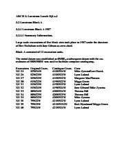
Block A was the most southern site in the locale. The excavation block consisted of 12 contiguous 1m2 units dug in a 3m x 4m rectangle. The block was the least productive of cultural materials, and bone preservation was the poorest. Under the sod, the black loam layer appeared at 5 cm below surface, and the glacial clay at 25 cm below surface. Excavators described the soil matrix as gritty and silty, and it became concrete hard when dried.
The occupation or bone layer extended from 10 to 25 cm below surface and consisted of a contiguous scatter of FCR and unidentifiable large ungulate bone which was heavily processed and intensively scavenged by carnivores. Most cultural materials were recovered within this layer. Fire cracked rock (FCR) and small burnt bone fragments were present but no intact hearths or processing features were evident.
Non-cultural materials included limestone and other natural pebbles derived from the parent till. (These small limestone pebbles were apparent in the occupation layers in other blocks as well). Root and rodent disturbance was extensive throughout Block A. Most units were excavated to gravelly clay till. Nine of the twelve units were dug to level 4b, which ended at 40 cm b.s.
No further excavations were done at this site. No C14 dates were taken.
Scope and Content
Sub-sub-sub series contains: Summary information of field methology, number and co-ordinates of excavations, personnel and their staff position; Field journals are daily records of recoveries, features and activities at the site; Site records include excavation level and unit summaries, feature sheets, profiles; sample records and maps; Artifact catalogues are lists and identifications of all artifacts recovered; Photographs are of excavation units, features, the landscape and personnel.
Field journals have been scanned in multi-page PDF files. Artifact catalogues are PDF files in spreadsheet format. Photographs are in jpeg format.
History / Biographical
Large scale excavations of five block sites took place in 1987 under the direction of Bev Nicholson with Jane Gibson as crew chief. Block A consisted of 12 excavation units.
Scope and Content
Sub-sub-sub series contains: Summary information of field methology, number and co-ordinates of excavations, personnel and their staff position.
The high biodiversity and evidence of pre-Europeon contact prompted the decision to test the Crepeele locale. The survey was named in recognition of the Casselman family, the original landowners.
Archaeological testing began in the Crepeele locale in May 2003 on property now owned by the Crepeele family. The locale covers over 6 sections or approximately 3,800 acres of land in an area of stabilized sand dunes and wetlands covered with mixed forest and prairie grass. Given the terrain, the size of the crew and time constrains, an area of approximately 60 acres was chosen for the survey. The survey used the established archaeological methodology of walking the selected area and using a shovel test surveyed grid. The use of GIS technology to locate the exact test spot and record the information into a GIS database was a significant advance and was one of the advantages of the integration of multi-disciplinary techniques encouraged by the SCAPE project. Over one half of the test pits resulted in the recovery of cultural materials. The results of the Casselman survey indicated several areas for further examination including areas that became the Crepeele, Sarah and Graham sites.
Scope and Content
Sub sub series has been divided into five sub sub sub series including: (1) Summary information; (2) Field journals; (3) Site records; (4) Artifact catalogues; and (5) Photographs.
Field journals have been scanned in multi-page PDF files. Artifact catalogues are PDF files in spreadsheet format. Photographs are in jpeg format.
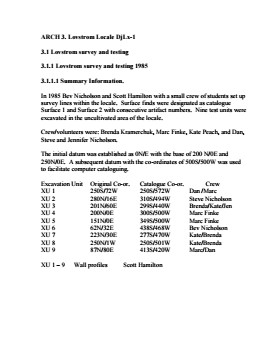
History / Biographical
In 1985 the Lovstrom locale was tested by Drs. Nicholson and Hamilton with 5 students. An extensive survey and nine excavations units were opened. This testing indicated the presence of artifacts manufactured by Blackduck and Duckbay peoples from the boreal forest and northern parkland areas. Other ceramics diagnostic of groups from the Saskatchewan Basin and the Middle Missouri area were also recovered in surface collection from the cultivated area of the locale.
Scope and Content
Sub-sub-sub series contains: Summary information of field methology, number and co-ordinates of excavations, personnel and their staff position.
Field journals have been scanned in multi-page PDF files. Artifact catalogues are PDF files in spreadsheet format. Photographs are in jpeg format.
History / Biographical
Under Dr. Nicholson’s direction and crew chief Brenda Kramarchuk with crew of Kate Peach and Blaine Frenette an additional sample of 15 units were excavated in 1986. This work confirmed the results of the first season, and resulted in an increased sample of faunal material, lithics, ceramics, and in the identification of distinctive ceramic clusters from different locations within the locale. These two seasons of testing satisfactorily demonstrated the presence of a large Prehistoric locale that warranted further exploration.
Scope and Content
Sub-sub-sub series contains: Summary information of field methology, number and co-ordinates of excavations, personnel and their staff position.
Block B consisted of 20 contiguous 1m2 units excavated to 30 cm below surface. (except unit 58 which was excavated to 35 cm bs to obtain extended soil profile). The block is situated in recent oak and poplar forest at the head of a ravine leading to Jock’s Creek, adjacent to an area cleared for market gardening. As was the case with Block A, the understory is heavily overgrown with hazelnut, chokecherry, saskatoon, and a poison ivy/sarsaparilla ground cover.
The soil levels below the sod in Block B consisted of a black, silty, and gritty loam layer from 5 cm to 23 cm below surface, a yellow and sandy clay from 23 cm to 30 cm below surface, and glacial till at 30 cm below surface. As in Block A, limestone cobbles were found throughout the occupation level around the bone. It is evident that bioturbation – primarily tree roots and rodent burrowing – have significantly altered patterns of original deposition of lithics, ceramics and small bone.
The faunal layer lay close to the surface, situated entirely in the black loam 5 cm – 23 cm below surface. The 23 cm depth also marked the end of the dark silty loam. At 10 cm below surface, a discernible patterning of the bone appeared. Concentrations of bone in narrow rows ran in an irregular pattern from the northwest to the southeast part of the block. This pattern was most apparent in the north end of the block which is the highest point in the block. In the same 1m2 unit, patches of weathered, very poorly preserved bone would be found lying close to patches of well preserved bone. It is believed that this variability in preservation results from uneven rates of burial due to taphic activities of pocket gophers or other agents of bioturbation. The same pattern of uneven preservation occurs over much of the locale but is most evident in Block B.
Diagnostic lithics included eleven projectile points that were predominantly Plains or Prairie Side-notch types, but included two unnotched triangular points. Cord-wrapped impressed rim sherds and body sherds were recovered. The ceramics are variants of the Woodland Blackduck horizon.
RC dates: XU49 – 675/80 BP XU 59 – 705/75BP.
Scope and Content
Sub-sub-sub series contains: Summary information of field methology, number and co-ordinates of excavations, personnel and their staff position; Field journals are daily records of recoveries, features and activities at the site; Site records include excavation level and unit summaries, feature sheets, profiles; sample records and maps; Artifact catalogues are lists and identifications of all artifacts recovered; Photographs are of excavation units, features, the landscape and personnel.