Skip header and navigation

Revise Search

20 records – page 1 of 1.

Report of the Second World Food Congress, The Hague, Netherlands, 16-30 June 1970

http://archives.brandonu.ca/en/permalink/specialcollections111
Part Of
RG 4 Manitoba Pool Elevator fonds
Description Level
Item
Date Range
1970
Part Of
RG 4 Manitoba Pool Elevator fonds
Collection
Manitoba Pool Elevator Library Collection
Creator
Food and Agriculture Organization of the United Nations
Description Level
Item
Item Number
Archives 14-1-16
Item Number Range
Archives 14-1-16
Start Date
1970
Date Range
1970
Publication
Rome : Food and Agriculture Organization ; London : H.M.S.O
Physical Description
2 v. : ill. , ports. ; 23 cm
Subject Access
Food supply Congresses
Nutrition Congresses
Storage Location
Library has v. 2 only
Box 1-Agriculture I
Storage Range
Library has v. 2 only
Box 1-Agriculture I
Show Less
Part Of
RG 4 Manitoba Pool Elevator fonds
Description Level
Sub-series
GMD
textual records
Date Range
1947-1968
Part Of
RG 4 Manitoba Pool Elevator fonds
Description Level
Sub-series
Series Number
MPE A
Item Number
30
GMD
textual records
Date Range
1947-1968
Physical Description
13 cm
Scope and Content
Teulon Co-operative Elevator Association Limited Organizational papers: 1961 Directors' Resolution, 18 October 1961 Minutes of Executive Board meetings, volume 1, 27 March 1947 - volume 3, 17 October 1968 Corporate Name: Rural Municipality of Rockwood MPE A 31 Dominion City 13 cm 1960 - 1969 Dominion City Co-operative Elevator Association Limited Minutes of Executive Board meetings, volume 1, 2 May 1960 - volume 2, 29 September 1969 Correspondence, 1960 (1 letter) Corporate Name: Rural Municipality of Franklin
Show Less

MPE A 16 Foxwarren

http://archives.brandonu.ca/en/permalink/descriptions8235
Part Of
RG 4 Manitoba Pool Elevator fonds
Description Level
Sub-series
GMD
textual records
Date Range
1926-1985
Part Of
RG 4 Manitoba Pool Elevator fonds
Description Level
Sub-series
Series Number
MPE A 16
GMD
textual records
Date Range
1926-1985
Physical Description
42 cm
Scope and Content
Foxwarren Co-operative Elevator Association Limited Organizational papers: 1926 - 1969 Shareholders meetings By-laws, 24 June 1926 Directors meetings By-laws, 24 June 1926 By-laws, no date By-law no. 8, 1927 Indenture between MPE and FCE, 1 August 1927 By-laws nos. 1-10 approved, no date By-law nos. 12 and 13, 14 July 1931Shareholders meeting By-laws 12 and 13, 14 July 1931 Directors meeting By-laws 12 and 13, 14 July 1931 Application for one share of stock, 14 July 1931 Agreement between FCE and MPE, 1 August 1931 By-law no. 14, 19 November 1931 Agreement between FCE and MPE, 1 February 1933 Meeting re: By-law no. 15, 16 February 1933 Agreement between FCE and MPE, 15 October 1936 By-law no. 16, 1 November 1939 By-law authorized share capital, 31 October 1941 Approval of cancellation of share capital, 31 October 1941 By-law nos. 18, 19, 20 and General By-laws, 26 July 1941 Agreement for sale, 19 July 1942 Operating agreement, 19 July 1942 Allocation of surplus, 1945 - 1946 By-law no. 21, 30 October 1947 Allocation of surplus, 15 January 1949 By-law no. 22, 6 June 1949 Agreement between FCE and MPE, 1 August 1951 By-law no. 23, 24 November 1951 Allocation of surplus, 15 January 1952 Directors' Resolution, 18 October 1961 Agreement between FCE and MPE, 15 December 1966 By-law no. 26, 8 March 1967 General By-laws, 16 April 1969 Arrangement agreement, 12 June 1969 Transfer agreement, 12 June 1969 Approval of arrangement and transfer agreements, no date By-law re: Members equities, no date Approval of financial statement, no date Transfer of surplus, no date Minutes of Executive Board meetings, volume 1, 1926 - volume 11, 14 November 1985 Minutes of Shareholders Annual meetings, 1927 - 1971 (31 reports) Financial records and statistics Statement of surplus, 1938 - 1955 (16 reports) Final statements, 1933 - 1952 (18 reports) Auditors' reports, 1928 - 1968 (29 reports) Analysis of Operating Results, 1951 - 1963 (11 reports) Accounts paid to MPE and charged to Station cash surplus, 1931 - 1945 (4 reports) Detail of grain earnings, 1963 - 1968 (5 reports) Review of Operating Result, 1961 - 1962 Surplus payment, 1943 - 1949 Percentage of handle, 11 December 1928 Statement of grain account and handle, 25 July 1931 Equity statement, 1 May 1932 Statement of surplus for deceased member's accounts, 17 June 1948 Analysis of capital loan, 31 July 1951 Sale price for screenings, 7 December 1961 Sale price for screenings, 25 July 1964 Capital debt, 16 June 1967 Statement of taxes, 1958 Financial statement of Red Cross 1949 campaign, 1949 Correspondence, 1931 - 1969 Membership list, 1935 - 1969 Miscellaneous Directors' attendance lists, 1943 -1944 Directors Reports, 1954 - 1968 Three newspaper articles, 1963 Crop information 1983-1985 Note on discussion concerning expanded fertilizer facilities at this point July 21 no year Note on Toll increases on Water way August 5, 1976 Note on metrification February 26, 1977 Corporate Name: Rural Municipality of Birtle.
Show Less

Brandon University campus

http://archives.brandonu.ca/en/permalink/descriptions7998
Part Of
Brandon University Photograph collection
Description Level
Item
GMD
graphic
Date Range
c. 1993
Part Of
Brandon University Photograph collection
Description Level
Item
Series Number
2.1
Item Number
BUPC 2.1.64
GMD
graphic
Date Range
c. 1993
Physical Description
6" x 4" (colour)
Scope and Content
Photograph was taken from the roof of the Library and shows the walkway and flower bed on the southeast corner of the George T. Richardson Centre. The Physical Plant H-Hut is visible in the top right hand corner.
Subject Access
campus photographs
Images
Show Less

John R. Brodie Science Centre flower beds

http://archives.brandonu.ca/en/permalink/descriptions3019
Part Of
Brandon University Photograph collection
Description Level
Item
GMD
graphic
Date Range
May 1978
Part Of
Brandon University Photograph collection
Description Level
Item
Series Number
2.1
Item Number
BUPC 2.1.40
GMD
graphic
Date Range
May 1978
Physical Description
5" x 3.5"
Scope and Content
Photograph shows a number of the flower beds located on the north side of the John R. Brodie Science Centre.
Subject Access
campus photographs
Show Less
Part Of
Brandon University Photograph collection
Description Level
Item
GMD
graphic
Date Range
May 1978
Part Of
Brandon University Photograph collection
Description Level
Item
Series Number
2.1
Item Number
BUPC 2.1.41
GMD
graphic
Date Range
May 1978
Physical Description
5" x 3.5" (colour)
Scope and Content
Photograph shows a sign bearing a campus map. The sign was located at the north entrance to the driveway.
Subject Access
campus photographs
Images
Show Less

John R. Brodie Science Centre flower beds

http://archives.brandonu.ca/en/permalink/descriptions3026
Part Of
Brandon University Photograph collection
Description Level
Item
GMD
graphic
Date Range
May 1978
Part Of
Brandon University Photograph collection
Description Level
Item
Series Number
2.1
Item Number
BUPC 2.1.42
GMD
graphic
Date Range
May 1978
Physical Description
5" x 3.5" (colour)
Scope and Content
Photograph shows a number of flower beds located on the north side of the John R. Brodie Science Centre.
Subject Access
campus photographs
Images
Show Less

Aerial view - Brandon University campus

http://archives.brandonu.ca/en/permalink/descriptions7989
Part Of
Brandon University Photograph collection
Description Level
Item
GMD
graphic
Date Range
c. 2000
Part Of
Brandon University Photograph collection
Creator
Photograph commissioned by Brandon University and taken by Yourview Aerial Scenics Ltd.
Description Level
Item
Series Number
2.1
Item Number
BUPC 2.1.55
GMD
graphic
Date Range
c. 2000
Physical Description
6" x 4" (colour)
Scope and Content
View is southwest from approximatley 16th Street between Princess and Rosser Avenues. Photograph shows the Brandon University campus, as well as surrounding residential blocks, including Flemming, J.R. Reid and Vincent Massey schools.
Subject Access
aerial photographs
campus photographs
campus buildings
Brandon streets
Images
Show Less

Aerial view - Brandon University campus

http://archives.brandonu.ca/en/permalink/descriptions7990
Part Of
Brandon University Photograph collection
Description Level
Item
GMD
graphic
Date Range
c. 2000
Part Of
Brandon University Photograph collection
Creator
Photograph commissioned by Brandon University and taken by Yourview Aerial Scenics Ltd.
Description Level
Item
Series Number
2.1
Item Number
BUPC 2.1.56
GMD
graphic
Date Range
c. 2000
Physical Description
6" x 4" (colour)
Scope and Content
View is west southwest from approximatley 16th Street between Princess and Lorne Avenues. Photograph shows the Brandon University campus, as well as surrounding residential blocks between 16th and 23rd Streets, Princess and Louise Avenues..
Subject Access
aerial photographs
campus photographs
campus buildings
Brandon streets
Images
Show Less

Aerial view - Brandon University campus

http://archives.brandonu.ca/en/permalink/descriptions7991
Part Of
Brandon University Photograph collection
Description Level
Item
GMD
graphic
Date Range
c. 2000
Part Of
Brandon University Photograph collection
Creator
Photograph commissioned by Brandon University and taken by Yourview Aerial Scenics Ltd.
Description Level
Item
Series Number
2.1
Item Number
BUPC 2.1.57
GMD
graphic
Date Range
c. 2000
Physical Description
6" x 4" (colour)
Scope and Content
View is west from approximatley 17th Street between Lorne and Louise Avenues. Photograph shows a portion of the Brandon University campus (excluding the Education Building and anything north of it), as well as surrounding residential blocks from approximatley 17th Street to 22nd Street.
Subject Access
aerial photographs
campus photographs
campus buildings
Brandon streets
Images
Show Less

Aerial view - Brandon University campus

http://archives.brandonu.ca/en/permalink/descriptions7992
Part Of
Brandon University Photograph collection
Description Level
Item
GMD
graphic
Date Range
c. 1990
Part Of
Brandon University Photograph collection
Description Level
Item
Series Number
2.1
Item Number
BUPC 2.1.58
GMD
graphic
Date Range
c. 1990
Physical Description
5" x 3.5" (colour)
Scope and Content
View is west northwest from approximatley 16th Street and Louise Avenue. Photograph shows the Brandon University campus, prior to the Library Extension, and a large portion of the city to the west of the campus.
Subject Access
aerial photographs
campus photographs
campus buildings
Brandon streets
Images
Show Less

Aerial view - Brandon University campus

http://archives.brandonu.ca/en/permalink/descriptions7993
Part Of
Brandon University Photograph collection
Description Level
Item
GMD
graphic
Date Range
c. 1990
Part Of
Brandon University Photograph collection
Description Level
Item
Series Number
2.1
Item Number
BUPC 2.1.59
GMD
graphic
Date Range
c. 1990
Physical Description
5" x 3.5" (colour)
Scope and Content
View is northwest from approximatley 16th Street and Louise Avenue. Photograph shows the Brandon University campus, prior to the Library Extension, and a large portion of the city to the west of the campus.
Subject Access
aerial photographs
campus photographs
campus buildings
Brandon streets
Show Less

Aerial view: Brandon College

http://archives.brandonu.ca/en/permalink/descriptions594
Part Of
Brandon University Photograph collection
Description Level
Item
GMD
graphic
Date Range
[fall 1964?]
Part Of
Brandon University Photograph collection
Description Level
Item
Series Number
2.1
Item Number
BUPC 2.1.2
GMD
graphic
Date Range
[fall 1964?]
Physical Description
5" x 4" (b/w)
Scope and Content
Brandon College looking south from 19th Street. Photograph was taken after Flora Cowan Hall was built but before construction of the Education Building.
Subject Access
aerial photographs
campus photographs
campus buildings
Brandon streets
Images
Show Less

Aerial view - Brandon College looking southwest

http://archives.brandonu.ca/en/permalink/descriptions601
Part Of
Brandon University Photograph collection
Description Level
Item
GMD
graphic
Date Range
[1963-1966]
Part Of
Brandon University Photograph collection
Description Level
Item
Series Number
2.1
Item Number
BUPC 2.1.8
GMD
graphic
Date Range
[1963-1966]
Physical Description
5" x 4" (b/w)
Scope and Content
Image shows the Brandon College campus from 17th Street looking southwest. The photo was taken after the completion of the original Music Building in 1963, but construction of the Education Building. Also visible are a number of properties on the 200 block of 18th Street and the 200 block of 20th Street.
Subject Access
aerial photographs
campus photographs
campus buildings
Brandon streets
Images
Show Less

Aerial view: Brandon College from 23rd Street

http://archives.brandonu.ca/en/permalink/descriptions602
Part Of
Brandon University Photograph collection
Description Level
Item
GMD
graphic
Date Range
[1963-1966]
Part Of
Brandon University Photograph collection
Description Level
Item
Series Number
2.1
Item Number
BUPC 2.1.9
GMD
graphic
Date Range
[1963-1966]
Physical Description
5" x 4" (b/w)
Scope and Content
Image is looking east northeast from approximately the 300 block of 23rd Street between Lorne and Louise Avenues. Photograph shows the Brandon College campus after the opening of the original Music Building in 1963, but before the construction of the Education Building in 1966. A number of house on the 300 blocks of 22nd and 21st Streets are visible in the foreground, with the A.E. McKenzie Seed Co., the Prince Edward Hotel and various grain elevators on the horizon.
Subject Access
aerial photographs
campus photographs
campus buildings
Brandon streets
Grain elevators
Images
Show Less

MPE B 16 Historical Topics

http://archives.brandonu.ca/en/permalink/descriptions10070
Part Of
RG 4 Manitoba Pool Elevator fonds
Description Level
Sub-series
GMD
textual records
Date Range
1925-1996
Part Of
RG 4 Manitoba Pool Elevator fonds
Description Level
Sub-series
Series Number
MPE B.16
GMD
textual records
Date Range
1925-1996
Physical Description
33 cm
History / Biographical
See fonds level description of RG 4 for history/bio of MPE
Scope and Content
This sub-series consists of historical topics created by MPE: 1. P.F. Bredt Invovement with MPE and death 1935-1940 2. MPE history 1941-1973 3a. Manitoba Wheat Pool and MPE history 1930-1939 3b. Manitoba Wheat Pool and MPE history 1925-1929 4. Manitoba Wheat Pool history 1924-1971 5a. On to Ottawa and Manitoba Delegation Committee 1958-1960 5b. MPE Miscellaneous history 1934-1959 6. Manitoba Wheat Pool history 1925-1929 7. Manitoba Wheat Pool 1925-1931 8. Pool Grain Marketing after 1929 Overpayment 1928-1936 9. Historical Review of Grain Trade and MPE 10. MPE Library 1948-1952 11. Coarse Grain Handling 1948-1953 12. Canadian Wheat Board 1935-1960 13. Saskatchewan Wheat Pool 1949 14. 1929 Overpayment and Williams/Stamp Commission Newspaper Clippings 1929-1931 15. Leonard Harman 1972 16. Historical Publications 1995-1996; no dates 17. Miscellaneous Historical 18. Western Agricultural Conference and Farm Bureau 1963-1965 19. Canadian Co-operatives 1961-1969 20. Miscellaneous Historical Topics 1930 21. Miscellaneous Historical Topics 1934-1936 22. International Wheat Agreement 1941-1948 23. World War Two 1939, 1944 24. Canadian National Railway System 25. Overpayment Aftermath 1932-1938 26. Miscellaneous Pool History 1925-1931 27. Miscellaneous History 28a. MPE History (Acquisitions, Philosophy) up to 1979 1931-1979 28b. MPE History (Acquisitions, Philosophy) up to 1979 1931-1979
Notes
Description by Jillian Sutherland (2009-2010)
Name Access
P.F. Bredt
W.J. Parker
J.T. Hull
C.H. Burnell
Manitoba Wheat Pool
Manitoba Pool Elevators
On to Ottawa
Central Office
Willaims Commission
Stamp Commission
Subject Access
Agriculture
Protest
Delegation
Storage Location
RG 4 Manitoba Pool Elevator fonds Series B: Central Office records
Show Less
Part Of
Brandon University Photograph collection
Description Level
Item
GMD
graphic
Date Range
c. 1985
Part Of
Brandon University Photograph collection
Description Level
Item
Series Number
2.1
Item Number
BUPC 2.1.60
GMD
graphic
Date Range
c. 1985
Physical Description
5" x 3.5" (colour)
Scope and Content
Photograph shows the removal of one of the houses formerly located on 20th Street between Louise and Princess Avenues. The houses on those blocks were removed to create parking lots for the University. A Fed Zavislak Ltd. Well Drilling & Trucking pickup truck is visible at the curb.
Subject Access
campus photographs
Brandon streets
Images
Show Less
Part Of
Brandon University Photograph collection
Description Level
Item
GMD
graphic
Date Range
c. 1985
Part Of
Brandon University Photograph collection
Description Level
Item
Series Number
2.1
Item Number
BUPC 2.1.61
GMD
graphic
Date Range
c. 1985
Physical Description
5" x 3.5" (colour)
Scope and Content
Photograph shows the removal of one of the houses formerly located on 20th Street between Louise and Princess Avenues. The houses on those blocks were removed to create parking lots for the University.
Subject Access
campus photographs
Brandon streets
Images
Show Less

Brandon University campus

http://archives.brandonu.ca/en/permalink/descriptions7999
Part Of
Brandon University Photograph collection
Description Level
Item
GMD
graphic
Date Range
c. 1993
Part Of
Brandon University Photograph collection
Description Level
Item
Series Number
2.1
Item Number
BUPC 2.1.65
GMD
graphic
Date Range
c. 1993
Physical Description
4" x 6" (colour)
Scope and Content
View is southwest from the roof of the George T. Richardson Centre. Photograph shows the curved glass wall of the John E. Robbins Library, the walkway between the Library and the Dining Hall, the Dining Hall and Darrach Hall.
Subject Access
campus photographs
campus buildings
Images
Show Less

Brandon University campus construction

http://archives.brandonu.ca/en/permalink/descriptions8007
Part Of
Brandon University Photograph collection
Description Level
Item
GMD
graphic
Date Range
c. 1996
Part Of
Brandon University Photograph collection
Description Level
Item
Series Number
2.1
Item Number
BUPC 2.1.73
GMD
graphic
Date Range
c. 1996
Physical Description
6" x 4" (colour)
Scope and Content
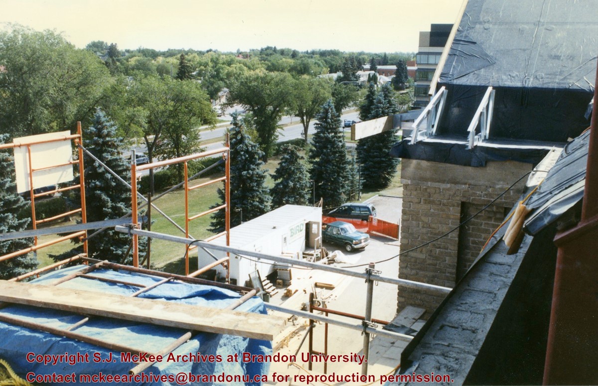
View is southeast from the roof of Clark Hall. Photograph shows some of the scaffolding and materials, as well as the construction trailer (Bird Construction) located on the driveway during the restoration of Clark Hall and the Brandon College Building.
Subject Access
campus photographs
campus construction
Images
Show Less

20 records – page 1 of 1.