The Atkinson site was named for the landowners Ken and Karen Atkinson who were very helpful to the archaeology and geoarchaeology crews that worked at the site. Their support made the project possible.
The Atkinson site story begins with the discovery of a charcoal lens eroding from the north bank of the Souris River in the summer of 2002. Study of Cultural Adaptations on the Prairie Ecozone (SCAPE) project geoarchaeologist Dr. Garry Running was exploring the stratigraphic layering in the bank when he noted the lens and reported it to Dr. Bev Nicholson. Upon closer examination, a tiny pressure flake was observed on the lens exposure and it was decided to collect a charcoal sample for radiocarbon dating.
The resulting date of 5250B.P cal. 4225 B.C. placed the site in the early Archaic period. A second date on bone collagen of 5580B.P. cal. 4500 B.C. confirmed the earlier date and gave an averaged date of circa 4400 B.C or 6,500 years ago.
The Atkinson site is one of the oldest excavated sites in Manitoba. Based on the date of the site and the kind of lithics (stone tools) present it is considered a Gowen occupation. The Atkinson site is evidence that bison hunters were active on the northern plains at a very early date. Similar sites have also been found on the High Plains in the U.S. and are referred to as the Mummy Cave Complex.
The Atkinson Site is of great importance as it is the first undisturbed site of this type to be excavated in Manitoba and extends the range of these sites south and east from the type-sites in central Saskatchewan. Based on the date and sample evidence further excavations were conducted by Dr. Nicholson's team. in 2003, 2004 and 2006.
Scope and Content
Sub series has been divided into three sub sub series including: (1) Atkinson 2003, (2) Atkinson 2004; (3) Atkinson 2006
The Duthie site is the first site identified in the Makotchi-Ded Dontipi locale. It was reported to Dr. Bev Nicholson by Doug Jackson, a local collector who had observed archaeological materials that had been exposed during the construction of Maple Hill Road northwest of Lauder. The site is named after the landowner, Randy Duthie.
The initial inspection of the exposed materials indicated that the eastern half of the site had been severely impacted by raising a road grade using an elevating grader. However, an undetermined amount of the site remained to the west, flanked by a low sand dune. Testing and preliminary excavations were conducted in 1992-93. In 1994 a field school added to the excavated sample. The undisturbed portion of the site, west of Maple Hill Road was situated at the base of a low sand dune and had an aspen and willow forest cover. The water table was approximately one meter below surface at the time of excavation. A rising water table has since prevented further excavations.
Two dates on bone collagen were obtained during excavations. These were 880+/-80 B.P. (Beta 62705) and 970+/-40 B.P. cal. 1030 A.D. (TO 13366). These dates are consistent with an Initial Middle Missouri cultural assignment. The site occupation is identified by the distinctive ceramics found there. Ceramics at the Duthie Site are tool impressed with incising and lip modeling with fabric impressions on most vessels. Jill Taylor analysed the ceramics from the site for a Specialist thesis, Brandon University (1994) and a Masters of Arts degree from the University of Saskatchewan. (Taylor 1995).
Analysis of residue from Duthie site pottery by Matthew Boyd recovered corn (Zea mays) phytoliths and bean (Phaseolus sp.) starch grains indicating consumption of these domesticates at the Duthie site. (Boyd 2006)
The occupation of this site indicates a migration of people from the south who were well acquainted with horticultural farming. These people had previously migrated to South Dakota following river valleys into the central plains from the eastern woodlands during late Hopewell times. It appears that they later migrated well to the north into southern Manitoba but there is no evidence that they remained there for more than a single year.
Boyd, M., C. Surette and B.A. Nicholson. 2006 Archaeobotanical Evidence of Prehistoric Maize (Zea mays) Consumption at the Northern Edge of the Great Plains. Journal of Archaeological Science 33: 1129-1140.
Taylor, J. 1994 An analysis of the ceramics recovered during 1992 and 1993 at the Precontact Duthie Site (DiMe-16). Specialist thesis, Brandon University.
Scope and Content
The Series has been divided into seven sub-series, including (1) Duthie site (2) Jackson site (3) Twin Fawns site (4) Vera site (5) Schuddemat site (6) Bradshaw site (7) Hollow B site.
Field journals have been scanned in multi-page PDF files. Artifact catalogues are PDF files in spreadsheet format. Photographs are in jpeg format.
History / Biographical
Based on the results of the testing in 2002 and the radiocarbon date of 6,500 years before present, further excavation was warranted at the Atkinson site. In 2003 Field Chief Holly Alston and crew Shayne Kolesar and Andrea Richards opened a 42m test excavation (units 1 - 4) that included the hearth area.
The site area was covered with a huge sand dune that was slowly sliding into the river as the supporting bank eroded away. As the dune was removed a late woodland camp was found at the dune interface and a large chunk of charcoal dated this occupation to 440+/-60 B.P. cal.1440A.D. This indicated that the dune was a relatively late incursion over the site. This occupation is likely connected to subsequent testing to the east in 2005 that came to be known as Atkinson II.
Methodology:
The crew began shovel shaving the upper strata with the intention of establishing an arbitrary datum when artifacts were encountered or when a level 25cm above the hearth was reached. At 25cm above the hearth an arbitrary surface datum was established and excavation in 5cm levels began. The overbank deposited matrix was a dense, compacted silt clay and it was necessary to soak the excavated materials in buckets and then water screen the material with a high pressure pump over ¼ inch hardware cloth.
Lithic flakes were found at 10cm below datum, above the hearth level. In the next level, large bone, a broken projectile point and additional flakes were found. Increasing amounts of bone and lithic flakes were found as the excavation continued through levels 3 to 5. The top of the hearth was identified at 28cm below datum, below a 2cm layer of well-sorted sand. This sand layer was confined to a small area directly overlying the hearth. It was considered to be a deliberate quenching of the hearth.
After the conclusion of excavating level 6 the hearth was profiled and photographed. The charcoal and ash layer of the hearth was shown to be directly below the sand layer. Levels 6 and 7 revealed a bison bone bed that was consistent with primary and secondary butchering including elements from the vertebral column and appendicular skeleton. Two additional Gowen (Mummy Cave Series) projectile points were also recovered adjacent to the hearth. Level 8 continued to produce larger amounts of bone and many lithic flakes. Level 9 produced a few bone fragments and a small number of lithic flakes. At the conclusion of the excavations, the crew shoveled sand down from the dune to protect the site over winter and through any subsequent spring flooding.
Scope and Content
Sub-sub-sub series contains: Summary information of field methology, number and co-ordinates of excavations, personnel and their staff position; Field journals are daily records of recoveries, features and activities at the site; Site records include excavation level and unit summaries, feature sheets, profiles; sample records and maps; Artifact catalogues are lists and identifications of all artifacts recovered; Photographs are of excavation units, features, the landscape and personnel.
Field journals have been scanned in multi-page PDF files. Artifact catalogues are PDF files in spreadsheet format. Photographs are in jpeg format.
History / Biographical
The Atkinson site had been flooded in 2005 and there was concern about the amount of damage that might have occurred. A small crew of Tomasin Playford, Michelle Drysdale and Jessica McKenzie returned to the Atkinson site with the goals of obtaining a detailed profile of the stratigraphy at the north end of the occupation and to determine if the site extended contiguously towards the east. Two test pits were planned as well as the investigation of a couple of hearths found eroding from the riverbank Work commenced July 4th and finished July 21st.
To the north of XU 8 (Gowen occupation) an excavation unit 18 was opened and shovel shaved to a depth of 200cm. At 195cm below surface a point bar deposit was identified indicating that any lower occupations would likely have been eroded by an earlier channel cutting event prior to formation of this point bar depositional event. Golf tees were inserted into the edge of the profile to indicate the 5cm levels superimposed on a digital photo of the section. Lithic flakes and bone fragments were scattered thoughout the stratigraphic column. A radiocarbon date of 440 B.P. was obtained from the unit, indicating a much later occupation than Gowen.
Unit 19 was excavated but only yielded a small Besant component containing a small hearth (H#3) In level 9, a point tip and a small biface as well as a few undecorated pot sherds were recovered. These two units defined the extent of the Atkinson I site. An unknowable area of the site has been eroded away by the encroaching Souris River.
The two small exposed hearths were excavated but only yielded a small amount of material. Hearth 4, at the western edge of the Atkinson block yielded only a small amount of charcoal , mixed with burnt bone and a few small lithic flakes. Hearth 5, located in the high cut bank west of the main site yielded a small amount of bone from a small ungulate, a muskrat and a bird as well as a percussion cap. This latter recovery indicated that this was an early historic period site.
Scope and Content
Sub-sub-sub series contains: Summary information of field methology, number and co-ordinates of excavations, personnel and their staff position; Field journals are daily records of recoveries, features and activities at the site; Site records include excavation level and unit summaries, feature sheets, profiles; sample records and maps; Artifact catalogues are lists and identifications of all artifacts recovered; Photographs are of excavation units, features, the landscape and personnel.
The high biodiversity and evidence of pre-Europeon contact prompted the decision to test the Crepeele locale. The survey was named in recognition of the Casselman family, the original landowners.
Archaeological testing began in the Crepeele locale in May 2003 on property now owned by the Crepeele family. The locale covers over 6 sections or approximately 3,800 acres of land in an area of stabilized sand dunes and wetlands covered with mixed forest and prairie grass. Given the terrain, the size of the crew and time constrains, an area of approximately 60 acres was chosen for the survey. The survey used the established archaeological methodology of walking the selected area and using a shovel test surveyed grid. The use of GIS technology to locate the exact test spot and record the information into a GIS database was a significant advance and was one of the advantages of the integration of multi-disciplinary techniques encouraged by the SCAPE project. Over one half of the test pits resulted in the recovery of cultural materials. The results of the Casselman survey indicated several areas for further examination including areas that became the Crepeele, Sarah and Graham sites.
Scope and Content
Sub sub series has been divided into five sub sub sub series including: (1) Summary information; (2) Field journals; (3) Site records; (4) Artifact catalogues; and (5) Photographs.
Field journals have been scanned in multi-page PDF files. Artifact catalogues are PDF files in spreadsheet format. Photographs are in jpeg format.
History / Biographical
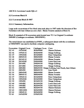
Large scale excavations of five block sites took place in 1987 under the direction of Bev Nicholson with Jane Gibson as crew chief. Block A consisted of 12 excavation units.
Scope and Content
Sub-sub-sub series contains: Summary information of field methology, number and co-ordinates of excavations, personnel and their staff position.
Field journals have been scanned in multi-page PDF files. Artifact catalogues are PDF files in spreadsheet format. Photographs are in jpeg format.
History / Biographical
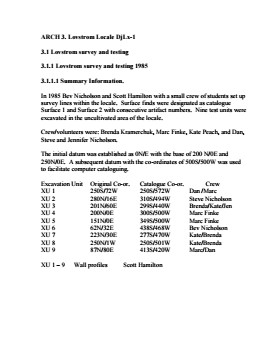
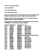
In 1985 the Lovstrom locale was tested by Drs. Nicholson and Hamilton with 5 students. An extensive survey and nine excavations units were opened. This testing indicated the presence of artifacts manufactured by Blackduck and Duckbay peoples from the boreal forest and northern parkland areas. Other ceramics diagnostic of groups from the Saskatchewan Basin and the Middle Missouri area were also recovered in surface collection from the cultivated area of the locale.
Scope and Content
Sub-sub-sub series contains: Summary information of field methology, number and co-ordinates of excavations, personnel and their staff position.
Field journals have been scanned in multi-page PDF files. Artifact catalogues are PDF files in spreadsheet format. Photographs are in jpeg format.
History / Biographical
Under Dr. Nicholson’s direction and crew chief Brenda Kramarchuk with crew of Kate Peach and Blaine Frenette an additional sample of 15 units were excavated in 1986. This work confirmed the results of the first season, and resulted in an increased sample of faunal material, lithics, ceramics, and in the identification of distinctive ceramic clusters from different locations within the locale. These two seasons of testing satisfactorily demonstrated the presence of a large Prehistoric locale that warranted further exploration.
Scope and Content
Sub-sub-sub series contains: Summary information of field methology, number and co-ordinates of excavations, personnel and their staff position.
Field journals have been scanned in multi-page PDF files. Artifact catalogues are PDF files in spreadsheet format. Photographs are in jpeg format.
History / Biographical
Large scale excavations of five block sites took place in 1987 under the direction of Bev Nicholson with Jane Gibson as crew chief. Block B consisted of 21 excavation units.
Scope and Content
Sub-sub-sub series contains: Summary information of field methology, number and co-ordinates of excavations, personnel and their staff position.
Field journals have been scanned in multi-page PDF files. Artifact catalogues are PDF files in spreadsheet format. Photographs are in jpeg format.
History / Biographical
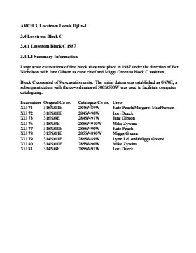
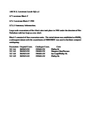
Large scale excavations of five block sites took place in 1987 under the direction of Bev Nicholson with Jane Gibson as crew chief. Block C consisted of nine excavation units. Miggs Green was Block C assistant.
Scope and Content
Sub-sub-sub series contains: Summary information of field methology, number and co-ordinates of excavations, personnel and their staff position.
Field journals have been scanned in multi-page PDF files. Artifact catalogues are PDF files in spreadsheet format. Photographs are in jpeg format.
History / Biographical
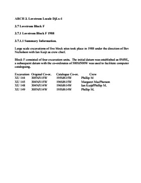
Large scale excavations of four block sites took place in 1988 under the direction of Bev Nicholson with Ian Kuijt as crew chief. Block F consisted of 4 excavation units.
Scope and Content
Sub-sub-sub series contains: Summary information of field methology, number and co-ordinates of excavations, personnel and their staff position.
Field journals have been scanned in multi-page PDF files. Artifact catalogues are PDF files in spreadsheet format. Photographs are in jpeg format.
History / Biographical
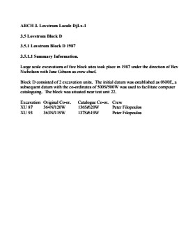
Large scale excavations of five block sites took place in 1987 under the direction of Bev Nicholson with Jane Gibson as crew chief. Block D consisted of 2 excavation units.
Scope and Content
Sub-sub-sub series contains: Summary information of field methology, number and co-ordinates of excavations, personnel and their staff position.
Field journals have been scanned in multi-page PDF files. Artifact catalogues are PDF files in spreadsheet format. Photographs are in jpeg format.
History / Biographical
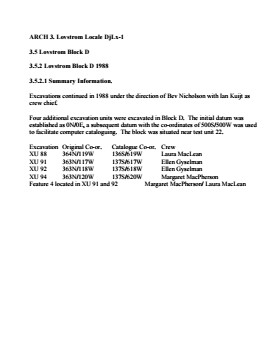
Large scale excavations of five block sites took place in 1988 under the direction of Bev Nicholson with Ian Kuijit as crew chief. Four excavation units were added to Block D.
Scope and Content
Sub-sub-sub series contains: Summary information of field methology, number and co-ordinates of excavations, personnel and their staff position.
Field journals have been scanned in multi-page PDF files. Artifact catalogues are PDF files in spreadsheet format. Photographs are in jpeg format.
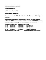
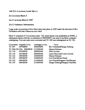
History / Biographical
Large scale excavations of five block sites took place in 1987 under the direction of Bev Nicholson with Jane Gibson as crew chief. Block E consisted of 7 excavation units.
Scope and Content
Sub-sub-sub series contains: Summary information of field methology, number and co-ordinates of excavations, personnel and their staff position.
Field journals have been scanned in multi-page PDF files. Artifact catalogues are PDF files in spreadsheet format. Photographs are in jpeg format.
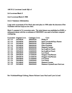
History / Biographical
Large scale excavations of four block sites took place in 1988 under the direction of Bev Nicholson with Ian Kuijt as crew chief. Block E consisted of 14 additional excavation units.
Scope and Content
Sub-sub-sub series contains: Summary information of field methology, number and co-ordinates of excavations, personnel and their staff position.
Field journals have been scanned in multi-page PDF files. Artifact catalogues are PDF files in spreadsheet format. Photographs are in jpeg format.
History / Biographical
Large scale excavations of four block sites took place in 1988 under the direction of Bev Nicholson with Ian Kuijt as crew chief. Block G consisted of 4 excavation units.
Scope and Content
Sub-sub-sub series contains: Summary information of field methology, number and co-ordinates of excavations, personnel and their staff position.
Field journals have been scanned in multi-page PDF files. Artifact catalogues are PDF files in spreadsheet format. Photographs are in jpeg format.
History / Biographical
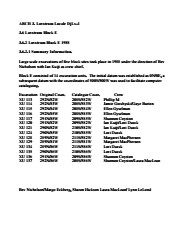
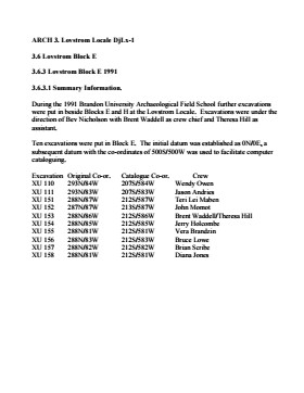
Large scale excavations of four block sites took place in 1988 under the direction of Bev Nicholson with Ian Kuijt as crew chief. Block H consisted of eight excavation units.
Scope and Content
Sub-sub-sub series contains: Summary information of field methology, number and co-ordinates of excavations, personnel and their staff position.
Field journals have been scanned in multi-page PDF files. Artifact catalogues are PDF files in spreadsheet format. Photographs are in jpeg format.
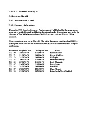
History / Biographical
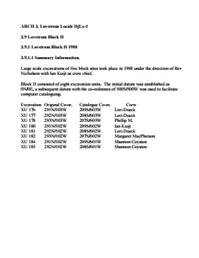
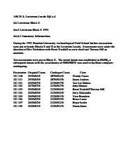
Large scale excavations of two block sites took place in 1988 under the direction of Bev Nicholson with Brett Waddell as crew chief and Theresa Hill as assistant. Block E consisted of 10 additional excavation units.
Scope and Content
Sub-sub-sub series contains: Summary information of field methology, number and co-ordinates of excavations, personnel and their staff position.
Field journals have been scanned in multi-page PDF files. Artifact catalogues are PDF files in spreadsheet format. Photographs are in jpeg format.
History / Biographical
Large scale excavations of two block sites took place in 1988 under the direction of Bev Nicholson with Brett Waddell as crew chief and Theresa Hill as assistant. Block H consisted of nine additional excavation units.
Scope and Content
Sub-sub-sub series contains: Summary information of field methology, number and co-ordinates of excavations, personnel and their staff position.
ARCH 2: North Lauder Locale
The North Lauder locale has a long archaeological and geological history that is important for understanding the forces that shaped the region. Archaeological research in the locale shows that the area has been occupied by humans for at least the past 6,500 years. Environmental forces provided an area of diverse resources that attracted early peoples.
Environment of the Lauder Sandhills
The North Lauder locale is part of the greater Lauder Sandhills area. The glaciers that covered this region began to recede approximately 11,000 years ago leaving a large lake known as glacial Lake Hind. The Souris River, the Lauder Sandhills and the Oak Lake Aquifer are remnants of the environmental and geological forces that shaped the region.
The Lauder Sandhills region is characterized by a landscape of sand sheets and stabilized sand dunes interspersed with a variety of wetlands. This complex topographic and hydrological situation favoured the development of an island mosaic of mixed forest, wetland and meadow, surrounded by mixed grass prairie. The result was a large, isolated ecotone which provided a rich variety of subsistence resources for hunter-gatherers.
Research in the Lauder Sandhills
Archaeologists from Brandon University have been conducting research in the Lauder Sandhills since 1991. Research in the North Lauder locale has focused on the Atkinson site, a 6,500 year old hunter-gatherer site and Flintstone Hill.
The Atkinson site
The Atkinson site is one of the oldest excavated sites in Manitoba and has been Radiocarbon dated to 6,500 years before present. The Atkinson site is located on the bank of the Souris River and was discovered when a hearth (fire pit) was seen eroding out of the bank. Based on the date of the site and the kind of lithics (stone tools) present it is considered a Gowen occupation. The Atkinson site is evidence that bison hunters were active on the northern plains at a very early date. Similar sites have also been found on the High Plains in the U.S. and are referred to as the Mummy Cave Complex.
The Atkinson Site is of great importance as it is the first undisturbed site of this type to be excavated in Manitoba and extends the range of these sites south and east from the type-sites in central Saskatchewan.
Flintstone Hill
The geomorphology of the glacial Lake Hind Basin over the past 11,000 years is known primarily through the study of a cut bank along the Souris River. Flint Stone Hill contains the most complete stratigraphic record for the post-glacial period on the northern plains. The site has been extensively studied by geoarchaeologists, geologists and paleoenvironmentalists over many years and their findings have contributed to our understanding of the region.
The North Lauder locale Borden designations of Atkinson site DiMe-27 and Flintstone Hill site DiMe-26.
Borden System
Archaeological sites in Canada are identified by the Borden system, which is a uniform site designation system. The country is divided into grids based on latitude and longitude in blocks of 10 x 20 minutes. The first 4 letters indicate the block and the following numbers indicate the actual site. For example the area of the Lauder Sandhills in southwestern Manitoba is identified by the letters DM and the North Lauder locale within that area is DiMe. The Atkinson site is DiMe-27 and the Flintstone Hill site DiMe-26. As new sites are discovered they will be numbered sequentially.
Scope and Content
The Series has been divided into two sub-series, including (1) Atkinson site DiMe-27 and Flintstone Hill site DiMe-26.