Skip header and navigation

Revise Search

20 records – page 5 of 1.

Residential Brandon, looking west postcard

http://archives.brandonu.ca/en/permalink/descriptions13875
Part Of
Fred McGuinness collection
Description Level
Item
GMD
graphic
Date Range
1910s
Accession Number
20-2009
Part Of
Fred McGuinness collection
Creator
Published by Christie's Bookstore, Brandon, Man.
Description Level
Item
Series Number
McG 9
Item Number
20-2009.185
Accession Number
20-2009
GMD
graphic
Date Range
1910s
Physical Description
3.5" x 5.5" (colour)
Material Details
postcard
Scope and Content
Photograph shows a street view of Lorne Avenue and 4th Street facing west. Brandon College can be seen at the end of Lorne Avenue.
Notes
Part of "Christie's Brandon Series of Six Colored Picture Postcards of Brandon, Manitoba, The Crown Series, Published by Christie's Bookstore, Brandon, Man." [note: missing sixth postcard]. Writing on the front of the photograph reads: Residential Brandon, Man. Looking West. Photograph likely taken from St. Augustine's Church.
Name Access
Lorne Avenue
Subject Access
residences
street scenes
residential streets
Storage Location
RG 5 photograph storage drawer 2 (hanging photos)
Arrangement
From 20-2009 File 9
Images
Show Less

East side 10th Street facing north from Princess Avenue, Brandon, Manitoba

http://archives.brandonu.ca/en/permalink/descriptions8376
Part Of
Joseph H. Hughes collection
Description Level
Item
GMD
graphic
Date Range
1962
Accession Number
3-1997
Part Of
Joseph H. Hughes collection
Description Level
Item
Series Number
3-1997.1
Item Number
3-1997.1.6
Accession Number
3-1997
GMD
graphic
Date Range
1962
Physical Description
8"x 10" (b/w)
Physical Condition
good
Scope and Content
Photograph of an east side of 10th Street facing north from Princess Avenue. Visible businesses include: Thunderbird Bowl, Canadian Pacific Telegraphs, Pittsburgh Paint & Glass, Strand Theatre, Trans Canada Credit Loans, Ted Heming Jewellers, Carlton Cafe, McKenzie Seeds, Clement Block, Mitrou's Cafe and Tea Room, and Brandon Musical Supply Ltd. Vehicles parked on 10th Street are facing north.
Notes
Photograph dated from "Tara's Bulba," the movie playing at the Strand Theatre and similiar vehicles captured in the photograph.
Name Access
Thunderbird Bowl
Canadian Pacific Telegraphs
Pittsburgh Paint & Glass
Strand Theatre
Trans Canada Credit Loans
Ted Heming Jewellers
Carlton Cafe
McKenzie Seeds
Clement Block
Mitrou Building
Brandon Musical Supply Ltd.
10th Street
Subject Access
downtowns
street scenes
Brandon business buildings & facilities after 1940
Storage Location
RG 5 photograph storage drawer
Images
Show Less

Street scene Rosser Avenue and 8th Street intersection

http://archives.brandonu.ca/en/permalink/descriptions13705
Part Of
Fred McGuinness collection
Description Level
Item
GMD
graphic
Date Range
1906
Accession Number
20-2009
Part Of
Fred McGuinness collection
Description Level
Item
Series Number
McG 9
Item Number
20-2009.15
Accession Number
20-2009
GMD
graphic
Date Range
1906
Physical Description
6.5" x 4.25" (b/w)
Material Details
on matting
Physical Condition
Photographs have been glued to a backing board that has warped over time
Scope and Content
Photograph shows street view of north side of Rosser Avenue, primarily the 700 block. The Fleming Block, Beaubier Block and its Empire Hotel, A.M. Percival (a grocer), the Brandon Hardware Company (600 block), and the Arlington Hotel (500 block) are visible along the north side of the avenue. The Bank of Hamilton Building on the southeast corner of 8th Street and Rosser appears to be under construction. A sign in the second storey window above the main entrance reads: law office. The streets are muddy and a horse and buggy is traveling west on Rosser Avenue.
Notes
Writing on the front of the photograph matting reads: mud November 12, 1906, 339. The photograph appears to be taken from the interior of a builing on the southwest corner of 8th Street and Rosser Avenue. Page appears to be from a photo album.
Name Access
Fleming Block
Empire Hotel
D.W. Beaubier Block
A.M. Percival
Brandon Hardware Company
Rosser Avenue
Subject Access
Street scene
Transportation
downtown
grocers
storefronts
mud
dogs
horses
buggies
insurance agents
lawyers
Storage Location
RG 5 photograph storage drawer 2 (hanging photos)
Images
Show Less

Rosser Avenue and 8th Street during winter storm

http://archives.brandonu.ca/en/permalink/descriptions13706
Part Of
Fred McGuinness collection
Description Level
Item
GMD
graphic
Date Range
1906
Accession Number
20-2009
Part Of
Fred McGuinness collection
Description Level
Item
Series Number
McG 9
Item Number
20-2009.16
Accession Number
20-2009
GMD
graphic
Date Range
1906
Physical Description
6.5" x 4.25" (b/w)
Material Details
on matting
Physical Condition
Photographs have been glued to a backing board that has warped over time
Custodial History
On 16 November 1906, Manitoba was hit by a severe winter storm that began that Thursday evening and extended through the weekend. The Brandon Daily Sun ("Storm Extends Over a Large Territory," 17 Nov. 1906, 1) reported that rail and telegraph services had been disrupted, country roads were impassable, and business in town was at a stand still. Following the weekend, the daily reported the blizzard was one of the greatest in recent memory. CPR trains had been caught in drifts by Carberry and an express car had caught fire and was destroyed ("Worst Storm in Many Years," Brandon Daily Sun, 19 Nov. 1906, 1).
Scope and Content
Photograph shows street view of north side of Rosser Avenue, primarily the 700 block. The Fleming Block, Beaubier Block and its Empire Hotel, A.M. Percival (a grocer), the Brandon Hardware Company (600 block), and the Arlington Hotel (500 block) are visible along the north side of the avenue. The Bank of Hamilton Building on the southeast corner of 8th Street and Rosser appears to be under construction. The streets are muddy and a horse and buggy is traveling west on Rosser Avenue.
Notes
Writing on the front of the photograph matting reads: during the great storm of November 16 1906, 341. The photograph appears to be taken from the interior of a builing on the southwest corner of 7th Street and Rosser Avenue. Page appears to be from a photo album.
Name Access
Fleming Block
8th Street
Rosser Avenue
Subject Access
Street scene
downtown
storefronts
storms
winter
Storage Location
RG 5 photograph storage drawer 2 (hanging photos)
Images
Show Less

Queen's Hotel on the corner of 10th Street and Rosser Avenue

http://archives.brandonu.ca/en/permalink/descriptions13778
Part Of
Fred McGuinness collection
Description Level
Item
GMD
graphic
Date Range
1883
Accession Number
20-2009
Part Of
Fred McGuinness collection
Description Level
Item
Series Number
McG 9
Item Number
20-2009.89
Accession Number
20-2009
GMD
graphic
Date Range
1883
Physical Description
7.25" x 4.25" (b/w)
Material Details
on matting
Physical Condition
Left hand corner of mat is bent. Mock-up instructions are written in pencil at the bottom right hand corner. Portions of the photograph itself are marked with pen.
History / Biographical
The Queen's Hotel was located on the corner of Rosser Avenue and Tenth Street (Steen & Boyce, 1882. Brandon, Manitoba, Canada and Her Industries. Steen & Boyce Publishers Printers & Binders, 81.). Therefore this photo appears to display Rosser Avenue looking east. P.E. 11/06/09
Scope and Content
Photograph shows early Rosser Avenue under construction between 9th Street and 10th Street in the 1880s. Buildings that line the avenue are wood framed and there are wooden boardwalks in front of a few structures. On the north side of Rosser Avenue signs for Fortier & Bucke Commision Agents and Transit House (Hotel) can be seen. On the south side of Rosser Avenue, the Queen's Hotel and Robinson Brothers and Company groceries and dry goods store are open for business. A family appears to be standing on the stoop at the dry goods store. A boy is lounging in the entryway of the Queen's Hotel. A man is standing on a wooden plank that extends across the dirt road of Rosser Avenue between the dry goods store and the commission agents' shop.
Notes
The back of the photograph reads: FRED McGUINNESS
Name Access
Queen's Hotel
Rosser Avenue
Fortier & Bucke Commision Agents
Transit House
Robinson Brothers and Company
Subject Access
downtown
construction
Brandon Street Scenes Before 1940
hotels
hardware stores
street scenes
store exteriors
building exteriors
grocery stores
general stores
dry goods
Storage Location
RG 5 photograph storage drawer 2 (hanging photos)
Related Material
Lawrence Stuckey collection 1-2002.3.1C17
Images
Show Less

Stores near the corner of Rosser Avenue and 6th Street

http://archives.brandonu.ca/en/permalink/descriptions13783
Part Of
Fred McGuinness collection
Description Level
Item
GMD
graphic
Date Range
1881-1882
Accession Number
20-2009
Part Of
Fred McGuinness collection
Description Level
Item
Series Number
McG 9
Item Number
20-2009.94
Accession Number
20-2009
GMD
graphic
Date Range
1881-1882
Physical Description
9.25" x 6.25" (b/w)
Material Details
on matting
Physical Condition
Corners of photograph mat are bent. Picture is cracked.
Scope and Content
Photograph shows an early view of Brandon's 6th Street in the 1880s. The Winter & O'Neail Groceries & Provisions and James Smart Hardware storefronts have been photographed. A street sign designating 6th Street can be seen below the Winter & O'Neail sign. A horse and cart is parked in front of the grocery store. A number of men wearing hats and jackets are standing along the boardwalk while posing for the picture. Lumber/timber saws are displayed in teh windows of the hardware store.
Notes
Front of photograph reads: 6th Street, Brandon, Manitoba, 1881-1882, Entrance [to Winter & O'Neail] corner of Rosser Ave & 6th Street.
Name Access
James Smart Hardware store
Winter & O'Neail Groceries and Provisions
6th Street
Subject Access
downtown
hardware stores
Pioneers
dry goods
street scenes
Brandon Street Scenes Before 1940
grocery stores
Storage Location
RG 5 photograph storage drawer 2 (hanging photos)
Images
Show Less

Intersection of Rosser Avenue and 8th Street facing west

http://archives.brandonu.ca/en/permalink/descriptions13786
Part Of
Fred McGuinness collection
Description Level
Item
GMD
graphic
Date Range
[19--]
Accession Number
20-2009
Part Of
Fred McGuinness collection
Creator
Photographer: Brandon Sun
Description Level
Item
Series Number
McG 9
Item Number
20-2009.97
Accession Number
20-2009
GMD
graphic
Date Range
[19--]
Physical Description
8.5" x 5.25" (b/w)
Material Details
reproduction
Scope and Content
Photograph shows the 800 block of Rosser Avenue facing west. On the south side of Rosser Avenue the Nation Block, Christie's Bookstore, and Reesor's Clock can be seen. A number of horse and buggies/carriages are travelling along Rosser Avenue.
Name Access
Rosser Avenue
Reesor’s Jewellery
Reesor's clock
Subject Access
downtown
street scenes
Brandon Street Scenes Before 1940
Transportation
horses
buggies
Storage Location
RG 5 photograph storage drawer 2 (hanging photos)
Images
Show Less

Aerial view: Brandon University campus

http://archives.brandonu.ca/en/permalink/descriptions2576
Part Of
Brandon University Photograph Collection
Description Level
Item
GMD
graphic
Date Range
September 21, 1999
Part Of
Brandon University Photograph Collection
Description Level
Item
Series Number
9
Item Number
BUPC 9.36
GMD
graphic
Date Range
September 21, 1999
Physical Description
11" x 14" (colour)
History / Biographical
The photograph was taken for the Centennial of Brandon College/University.
Scope and Content
Aerial photograph taken looking southwest from approximately the northeast corner of Princess Avenue and 17th Street. The entire campus, as well as a number of residential streets are visible.
Notes
Negative is located with the photograph
Subject Access
campus buildings
aerial photographs
aerial photography
aerial views
cityscapes
Storage Range
Oversized drawer 4
Images
Show Less

Aerial view: Brandon College looking west

http://archives.brandonu.ca/en/permalink/descriptions595
Part Of
Aerial views and campus photographs
Description Level
Item
GMD
graphic
Date Range
c. spring 1963
Part Of
Aerial views and campus photographs
Description Level
Item
Series Number
2.1
Item Number
2.1.3
GMD
graphic
Date Range
c. spring 1963
Physical Description
10" x 8" (b/w)
Scope and Content
View is west to McDiarmid Drive from approximately 16th Street between Princess and Louise Avenues. Photograph shows: Brandon College, Fleming School, Coronation Park, and West End Community Centre.
Images
Show Less

Aerial view: Brandon College looking northwest

http://archives.brandonu.ca/en/permalink/descriptions599
Part Of
Aerial views and campus photographs
Description Level
Item
GMD
graphic
Date Range
late 1960s
Part Of
Aerial views and campus photographs
Description Level
Item
Series Number
2.1
Item Number
2.1.7
GMD
graphic
Date Range
late 1960s
Physical Description
5" x 4" (b/w)
Scope and Content
Brandon College. Looking north west over the valley after 1963 Music Building opening, but before trees were moved to the quadrangle.
Images
Show Less

Aerial view - Brandon College looking southwest

http://archives.brandonu.ca/en/permalink/descriptions601
Part Of
Brandon University Photograph collection
Description Level
Item
GMD
graphic
Date Range
[1963-1966]
Part Of
Brandon University Photograph collection
Description Level
Item
Series Number
2.1
Item Number
BUPC 2.1.8
GMD
graphic
Date Range
[1963-1966]
Physical Description
5" x 4" (b/w)
Scope and Content
Image shows the Brandon College campus from 17th Street looking southwest. The photo was taken after the completion of the original Music Building in 1963, but construction of the Education Building. Also visible are a number of properties on the 200 block of 18th Street and the 200 block of 20th Street.
Subject Access
aerial photographs
campus photographs
campus buildings
Brandon streets
Images
Show Less

Sewer pipe installation along 700 block of Rosser Avenue

http://archives.brandonu.ca/en/permalink/descriptions13736
Part Of
Fred McGuinness collection
Description Level
Item
GMD
graphic
Date Range
ca. 1906
Accession Number
20-2009
Part Of
Fred McGuinness collection
Description Level
Item
Series Number
McG 9
Item Number
20-2009.46
Accession Number
20-2009
GMD
graphic
Date Range
ca. 1906
Physical Description
6.5" x 4.25" (b/w)
Material Details
on matting
Physical Condition
Photographs have been glued to a backing board that has warped over time
Scope and Content
Photograph shows street view of north side of Rosser Avenue, primarily the 700 block, along which sewer pipe is being laid. Visible buildings and businesses include: The Fleming Block with Lowes Brothers Clothing and Manitoba Farmers Hedge and Wire Fence Company, the Beaubier Block and its Empire Hotel, A.M. Percival (a grocer), the Brandon Hardware Company (600 block), and the Arlington Hotel (500 block) are visible along the north side of the avenue. The Bank of Hamilton Building is on the southeast corner of 8th Street and Rosser Avenue.
Notes
Writing on the front of the photograph matting reads: 290. Page appears to be from a photo album.
Name Access
Fleming Block
Empire Hotel
D.W. Beaubier Block
A.M. Percival
Brandon Hardware Company
Arlington Hotel
Lowes Brothers Clothing
Subject Access
Street scene
downtown
grocers
storefronts
building exteriors
sewage
construction
Storage Location
RG 5 photograph storage drawer 2 (hanging photos)
Images
Show Less

Thompson's Groceries and Confectionary - exterior

http://archives.brandonu.ca/en/permalink/descriptions10133
Part Of
RG 12 Brandon and Area Photograph Collection
Description Level
Item
GMD
graphic
Date Range
c. 1925
Part Of
RG 12 Brandon and Area Photograph Collection
Description Level
Item
Series Number
2
Item Number
BAPC 2.21
GMD
graphic
Date Range
c. 1925
Physical Description
8" x 10" (b/w)
History / Biographical
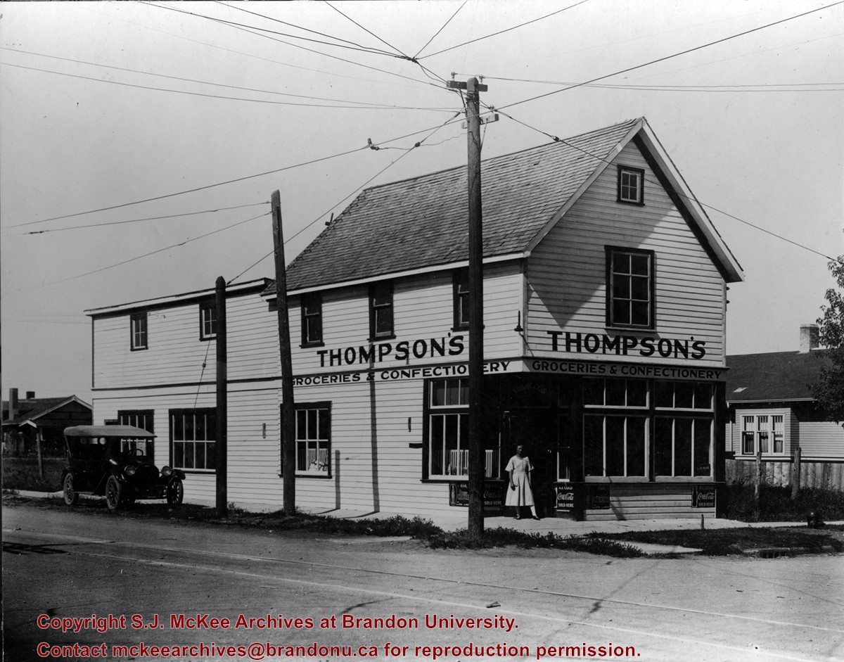
Thompson's Groceries and Confectionary was established in 1923 by Arthur Thompson (b. 1881 - d. May14, 1957) at 764 13th Street. From approximately 1925-1927, the store was operated by Alexander Thompson at 762 13th Street. The fate of the store from 1929-1935 is unclear. In 1929, Alexander Thompson was a grocer at 748 7th Street and in 1931 a Mrs. A Thompson was a grocer at 802 14th Street. There were two Thompson grocery and confectionary businesses in Brandon in 1933: Thompson's Confectionary at 745 13th Street and Thompson & Co. at 702 12th Street. In 1935, Arthur Thompson appears to have either taken over one of the earlier businesses or reopened his own grocery in its original location at 762 13th Street. He operated his store at this location into the mid-1950s. At some point following Thompson's death the building was bought by Frank Fitzpatrick and used for his upholstery store.
Custodial History
Donated by Frank Fitzpatrick.
Scope and Content
Photograph is looking northwest at the extrior of Thompson's Grocieries and Confectionary.
Notes
History/Bio information taken from Henderson's Directories (1917-1955) for Brandon, MB.
Name Access
Thompson's Groceries and Confectionary
13th Street
College Avenue
Subject Access
grocery stores
cityscapes
businesses
stores
Storage Location
BAPC photograph drawer
Images
Show Less

Driveway looking northwest

http://archives.brandonu.ca/en/permalink/descriptions730
Part Of
Aerial views and campus photographs
Description Level
Item
GMD
graphic
Date Range
c. 1963
Part Of
Aerial views and campus photographs
Description Level
Item
Series Number
2.1
Item Number
2.1.144
GMD
graphic
Date Range
c. 1963
Physical Description
3.5" x 5" (colour)
Material Details
Kodak paper
Scope and Content
Photograph is looking northwest from approximately the south entrance of the driveway and shows the Citizens' Science Building, the Brandon College Building and part of Clark Hall, as well as the drive way and part of the front lawn.
Images
Show Less

Aerial view: Brandon College campus looking northwest

http://archives.brandonu.ca/en/permalink/descriptions616
Part Of
Aerial views and campus photographs
Description Level
Item
GMD
graphic
Date Range
c. 1963
Part Of
Aerial views and campus photographs
Description Level
Item
Series Number
2.1
Item Number
2.1.24
GMD
graphic
Date Range
c. 1963
Physical Description
5" x 4" (b/w)
Scope and Content
View is northwest from approximately the corner of 18th Street and Louise Avenue. Photograph shows the Brandon College campus after the completion of Flora Cowan Hall.
Notes
BUPC 2.1.20 is a larger version of this photograph.
Images
Show Less

Two views looking east and west from Tupper St. overpass, Portage La Prairie, Manitoba

http://archives.brandonu.ca/en/permalink/descriptions10423
Part Of
RG 11 Lawrence Stuckey fonds
Description Level
Item
GMD
graphic
Date Range
April 19, 1965
Accession Number
1-2002
Part Of
RG 11 Lawrence Stuckey fonds
Creator
L.A. Stuckey
Description Level
Item
Series Number
3.3
Item Number
1-2002.3.3.CNR[136a]
Accession Number
1-2002
GMD
graphic
Date Range
April 19, 1965
Physical Description
4.25" x 2.5" (b/w)
Material Details
Negative
History / Biographical
Stuckey's notes: collection of George H. Harris, Winnipeg, Manitoba.
Custodial History
For custodial history see the collection level description of the Lawrence Stuckey collection.
Scope and Content
Image of two views looking east and west from Tupper St. overpass, Portage La Prairie, Manitoba, taken along the CNR mainline, Rivers substation.
Notes
From the collection of George H. Harris, Winnipeg, Manitoba.
Name Access
CNR
Portage La Prairie, Manitoba
Subject Access
railways
railway stations
towns
geographic features
Repro Restriction
The McKee Archives is the copyright holder of the Stuckey materials.
Storage Location
Lawrence Stuckey collection
Arrangement
[Mr. Stuckey put two negatives in same envelope. We have separated them and numbered them (136a) and (136b)].
Images
Show Less

Two views looking east and west from Tupper St. overpass, Portage La Prairie, Manitoba

http://archives.brandonu.ca/en/permalink/descriptions10427
Part Of
RG 11 Lawrence Stuckey fonds
Description Level
Item
GMD
graphic
Date Range
April 19, 1965
Accession Number
1-2002
Part Of
RG 11 Lawrence Stuckey fonds
Creator
L.A. Stuckey
Description Level
Item
Series Number
3.3
Item Number
1-2002.3.3.CNR[136b]
Accession Number
1-2002
GMD
graphic
Date Range
April 19, 1965
Physical Description
4.25" x 2.5" (b/w)
Material Details
Negative
History / Biographical
Stuckey's notes: collection of George H. Harris, Winnipeg, Manitoba.
Custodial History
For custodial history see the collection level description of the Lawrence Stuckey collection.
Scope and Content
Image of two views looking east and west from Tupper St. overpass, Portage La Prairie, Manitoba, taken along the CNR mainline, Rivers substation.
Notes
From the collection of George H. Harris, Winnipeg, Manitoba.
Name Access
CNR
Portage La Prairie, Manitoba
Subject Access
railways
railway stations
towns
geographic features
Grain elevators
Repro Restriction
The McKee Archives is the copyright holder of the Stuckey materials.
Storage Location
Lawrence Stuckey collection
Arrangement
[Mr. Stuckey put two negatives in same envelope. We have separated them and numbered them (136a) and (136b)].
Images
Show Less

Daly 18th Street overpass

http://archives.brandonu.ca/en/permalink/descriptions10139
Part Of
RG 12 Brandon and Area Photograph Collection
Description Level
Item
GMD
graphic
Date Range
[after 1963]
Part Of
RG 12 Brandon and Area Photograph Collection
Description Level
Item
Series Number
2
Item Number
BAPC 2.27
GMD
graphic
Date Range
[after 1963]
Physical Description
5" x 3.5" (b/w)
History / Biographical
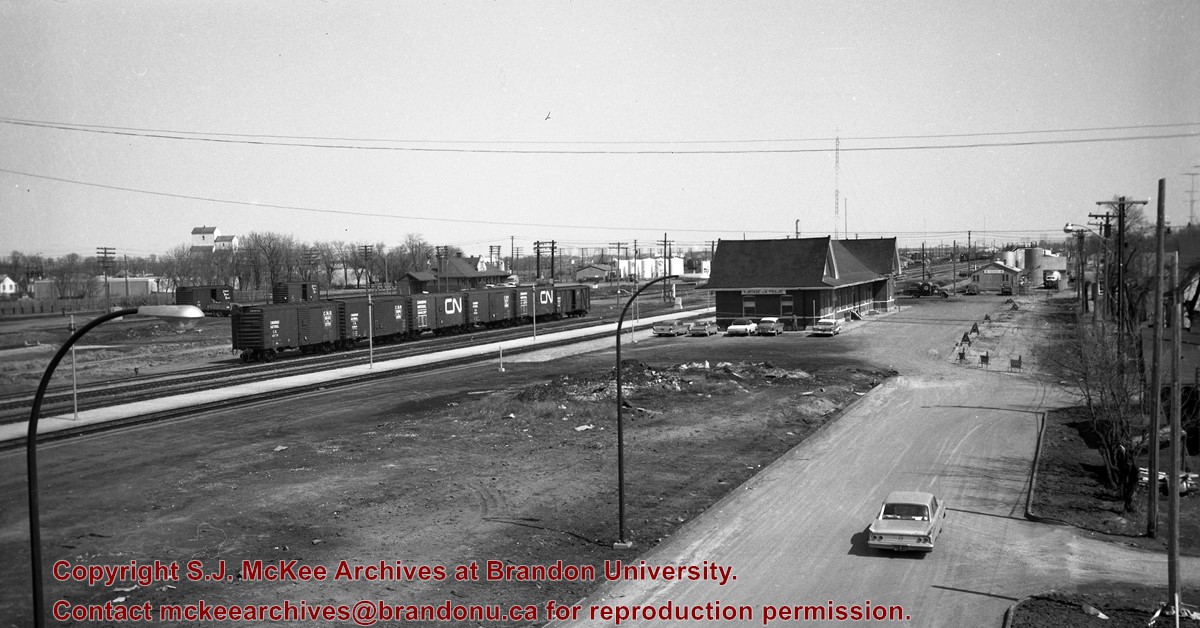
The overpass is named for Brandon's first mayor, Thomas Mayne Daly, and the street on which the overpass is located. The overpass opened in October 1963.
Scope and Content
Photograph is an aerial view of the Daly 18th Street Overpass (18th Street Bridge). Visible are a number of commercial and residential buildings in the north end of Brandon, MB. The view is northeast, probably taken from the roof of the old steam plant north of 20th Street and Rosser Avenue.
Name Access
Daly 18th Street Overpass
18th Street Bridge
Kane Equipment Ltd.
International Harvester Company of Canada
Pacific Avenue
Subject Access
northend
bridges
manmade geographic features
cityscapes
Storage Location
BAPC photograph drawer
Images
Show Less

Tenth Street looking towards CPR Station, Brandon, Man.

http://archives.brandonu.ca/en/permalink/descriptions13780
Part Of
Fred McGuinness collection
Description Level
Item
GMD
graphic
Date Range
[1917-1919]
Accession Number
20-2009
Part Of
Fred McGuinness collection
Description Level
Item
Series Number
McG 9
Item Number
20-2009.91
Accession Number
20-2009
GMD
graphic
Date Range
[1917-1919]
Physical Description
5.5" x 3.5" (colour)
Material Details
postcard
History / Biographical
According to Russ Gourluck (Silver Screens on the Prairie, Winnipeg: Great Plains Publications, 2012, 26), the Orpheum Theatre was in operation from 1917 to 1920 when it then became the Willis Theatre.
Scope and Content
Postcard shows the 100 block of 10th Street facing north. The CPR train station can be seen at the end of 10th Street. The sign for the Rex Cafe is visible on the west side of 10th Street. On the east side of 10th Street, billboards for Campbell & Campbell furniture are visible as well as signs for Pianos and the Orpheum Theatre. Motorists and cyclists share the road. Street car tracks run the length of 10th Street.
Notes
Postcard was manufactured by T.B. [Tichnor Brothers, Inc., 1908-1987] Cambridge, Massachusetts.
Name Access
10th Street
CPR Station
Orpheum Theatre
Rex Cafe
Campbell & Campbell
Brandon Municipal Railway
Subject Access
street scenes
building exteriors
store exteriors
automobiles
Transportation
street cars
bicycles
Storage Location
RG 5 photograph storage drawer 2 (hanging photos)
Images
Show Less

Ninth Street Looking South

http://archives.brandonu.ca/en/permalink/descriptions9210
Part Of
RG 11 Lawrence Stuckey fonds
Description Level
Item
GMD
graphic
Date Range
1911
Accession Number
1-2002
Part Of
RG 11 Lawrence Stuckey fonds
Creator
I.C. Barton (Chicago)
Description Level
Item
Series Number
3.1
Item Number
1-2002.3.1C22
Accession Number
1-2002
GMD
graphic
Date Range
1911
Physical Description
3 1/2" x 5"
Material Details
Negative
Custodial History
For custodial history see the collection level description of the Lawrence Stuckey collection.
Scope and Content
View of Ninth Street south from Christie Building
Notes
Shows: St. Paul's Church, Old City Hall, Prince Edward Hotel under construction
Name Access
Ninth Street Looking South
Subject Access
downtowns
businesses
hotels
city halls
churches
Brandon Street Scenes Before 1940
Repro Restriction
The McKee Archives is the copyright holder for the Stuckey materials.
Storage Location
Lawrence Stuckey collection
Images
Show Less

20 records – page 5 of 1.