Skip header and navigation

Revise Search

20 records – page 10 of 1.

Aerial view: Brandon University campus

http://archives.brandonu.ca/en/permalink/descriptions8049
Part Of
Aerial views and campus photographs
Description Level
Item
GMD
graphic
Date Range
1967-1969
Part Of
Aerial views and campus photographs
Description Level
Item
Series Number
2.1
Item Number
2.1.118
GMD
graphic
Date Range
1967-1969
Physical Description
5" x 3.5" (colour)
Scope and Content
View is west from 17th Street between Louise and Princess Avenues. Photograph shows the Brandon University Campus, Fleming School and Coronation Park, as well as a number of residential blocks.
Images
Show Less

Aerial view: Brandon University campus

http://archives.brandonu.ca/en/permalink/descriptions8050
Part Of
Aerial views and campus photographs
Description Level
Item
GMD
graphic
Date Range
c. 2000
Part Of
Aerial views and campus photographs
Creator
Photographer: Sandy Black
Description Level
Item
Series Number
2.1
Item Number
2.1.119
GMD
graphic
Date Range
c. 2000
Physical Description
8" x 5" (colour)
Scope and Content
View is southwest from the 200 block of 17th Street. Photograph shows the Brandon University campus, Kinsmen Stadium, Fleming School and a number of residential blocks.
Show Less

Aerial view: Brandon University campus

http://archives.brandonu.ca/en/permalink/descriptions8051
Part Of
Aerial views and campus photographs
Description Level
Item
GMD
graphic
Date Range
c. 1978
Part Of
Aerial views and campus photographs
Description Level
Item
Series Number
2.1
Item Number
2.1.120
GMD
graphic
Date Range
c. 1978
Physical Description
7" x 5" (colour)
Scope and Content
View is south southeast from approsimatley Rosser Avenue and 21st Street. Photograph shows the Brandon University campus, Kinsmen Stadium, Earl Oxford School, the Fair Grounds (including the Grand Stand and Race Track), and a number of residential blocks.
Images
Show Less

Aerial view: Brandon University campus

http://archives.brandonu.ca/en/permalink/descriptions8053
Part Of
Aerial views and campus photographs
Description Level
Item
GMD
graphic
Date Range
c. 1967
Part Of
Aerial views and campus photographs
Description Level
Item
Series Number
2.1
Item Number
2.1.122
GMD
graphic
Date Range
c. 1967
Physical Description
10" x 8" (colour)
Scope and Content
View is south southwest from approximatley the southwest corner of 18th Street and Princess Avenue. Photograph shows the University campus, Kinsmen Stadium, Earl Oxford School and residential blocks.
Images
Show Less

Aerial view: Brandon University campus

http://archives.brandonu.ca/en/permalink/descriptions8054
Part Of
Aerial views and campus photographs
Description Level
Item
GMD
graphic
Date Range
c. 1967
Part Of
Aerial views and campus photographs
Description Level
Item
Series Number
2.1
Item Number
2.1.123
GMD
graphic
Date Range
c. 1967
Physical Description
10" x 8" (colour)
Scope and Content
View is west from 17th Street between Louise and Princess Avenues to approximalety 25th Street. Photograph shows the University campus, Fleming School, Coronation Park and residential blocks.
Images
Show Less

Aerial view: Brandon University campus

http://archives.brandonu.ca/en/permalink/descriptions8057
Part Of
Aerial views and campus photographs
Description Level
Item
GMD
graphic
Date Range
c. 1967
Part Of
Aerial views and campus photographs
Description Level
Item
Series Number
2.1
Item Number
2.1.126
GMD
graphic
Date Range
c. 1967
Physical Description
10" x 8" (colour)
Scope and Content
View is southeast from north of the corner of Princess Avenue and 22nd Street to approximatley Brandon Avenue. Photograph shows the University campus, Kinsmen Stadium, Earl Oxford School, and residential blocks. Brandon Collegiate Institute (BCI) is visible in the upper left corner.
Images
Show Less

Aerial view: Brandon University campus

http://archives.brandonu.ca/en/permalink/descriptions8058
Part Of
Aerial views and campus photographs
Description Level
Item
GMD
graphic
Date Range
c. 1967
Part Of
Aerial views and campus photographs
Description Level
Item
Series Number
2.1
Item Number
2.1.127
GMD
graphic
Date Range
c. 1967
Physical Description
10" x 8" (b/w)
Scope and Content
View is west southwest from approximatley the northside of Princess Avenue just east of 18th Street. Photograph shows the University campus, part of Kinsmen Stadium and residential blocks.
Images
Show Less

Aerial view: Brandon University campus

http://archives.brandonu.ca/en/permalink/descriptions8059
Part Of
Aerial views and campus photographs
Description Level
Item
GMD
graphic
Date Range
c. 1967
Part Of
Aerial views and campus photographs
Description Level
Item
Series Number
2.1
Item Number
2.1.128
GMD
graphic
Date Range
c. 1967
Physical Description
10" x 8" (b/w)
Scope and Content
View is northwest from approximatley the southeast corner of 18th Street and Louise Avenue. Photograph shows the University campus and residential blocks.
Images
Show Less

Aerial view: Brandon University campus

http://archives.brandonu.ca/en/permalink/descriptions8060
Part Of
Aerial views and campus photographs
Description Level
Item
GMD
graphic
Date Range
c. 1978
Part Of
Aerial views and campus photographs
Description Level
Item
Series Number
2.1
Item Number
2.1.129
GMD
graphic
Date Range
c. 1978
Physical Description
10" x 8" (b/w)
Scope and Content
View is southwest from approximatley the corner of 17th Street and Princess Avenue to McDiarmid Drive. Photograph shows the Brandon University campus, Kinsmen Stadium, Fleming School, Coronation Park and residential blocks.
Images
Show Less

Aerial view: Brandon University campus

http://archives.brandonu.ca/en/permalink/descriptions8061
Part Of
Aerial views and campus photographs
Description Level
Item
GMD
graphic
Date Range
c. 1978
Part Of
Aerial views and campus photographs
Description Level
Item
Series Number
2.1
Item Number
2.1.130
GMD
graphic
Date Range
c. 1978
Physical Description
10" x 8" (b/w)
Scope and Content
View is west northwest from aproximatley 15th Street and Louise Avenue to 34th Street. Photograph shows the Brandon University campus, part of Kinsmen Stadium, Fleming School, Coronoation Park, Valleyview Centennial School, Sacred Heart School ?, and residential blocks.
Images
Show Less

Aerial view: Brandon University campus

http://archives.brandonu.ca/en/permalink/descriptions8062
Part Of
Aerial views and campus photographs
Description Level
Item
GMD
graphic
Date Range
c. 1978
Part Of
Aerial views and campus photographs
Description Level
Item
Series Number
2.1
Item Number
2.1.131
GMD
graphic
Date Range
c. 1978
Physical Description
10" x 8" (b/w)
Scope and Content
View is west northwest from aproximatley 16th Street and Louise Avenue to west of 34th Street. Photograph shows the Brandon University campus, part of Kinsmen Stadium, Coronoation Park, Valleyview Centennial School, part of the Assiniboine River and residential blocks.
Images
Show Less

Aerial view: Brandon University campus

http://archives.brandonu.ca/en/permalink/descriptions8064
Part Of
Brandon University Photograph collection
Description Level
Item
GMD
graphic
Date Range
[1972-1978]
Part Of
Brandon University Photograph collection
Description Level
Item
Series Number
2.1
Item Number
BUPC 2.1.133
GMD
graphic
Date Range
[1972-1978]
Physical Description
10" x 8" (b/w)
Scope and Content
View is southwest from approximatley 16th Street between Lorne Avenue and Princess Avenue. The view extends to approximately 26th Street. Photograph shows the Brandon University campus, Kinsmen Stadium, Fleming School, Coronation Park and residential blocks.
Images
Show Less

Aerial view: Brandon University campus

http://archives.brandonu.ca/en/permalink/descriptions8065
Part Of
Aerial views and campus photographs
Description Level
Item
GMD
graphic
Date Range
c. 1978
Part Of
Aerial views and campus photographs
Description Level
Item
Series Number
2.1
Item Number
2.1.134
GMD
graphic
Date Range
c. 1978
Physical Description
10" x 8" (colour)
Scope and Content
View is southwest from approximatley 16th Street and Princess Avenue to McDiarmid Drive. Photograph shows the Brandon University campus, Kinsmen Stadium, Fleming School, Coronation Park, J.R. Ried School and residential blocks.
Images
Show Less
Part Of
Alfred Angus Murray McPherson collection
Description Level
Box
GMD
textual records
Date Range
1938-1952
Accession Number
21-2006
Part Of
Alfred Angus Murray McPherson collection
Description Level
Box
File Number
9.1 - 9.18
Accession Number
21-2006
Other Numbers
Box I
GMD
textual records
Date Range
1938-1952
Scope and Content
Contains the following files: 9.1 Class list and lost alumni 1941-1948 9.2 "Spectrum" April 1944 9.3 "The Sickle" 1941-1945 (missing 1944) 9.4 Graduation programmes 1927, 1940-1952 (includes photo of Arts Banquet, Brandon College 1942) 9.5 "The New Era" 1947 9.6 Murray McPherson diary 1942 9.7 The Quill and The Sickle account book [1939-1941] 9.8 Brandon College documentation 1942-1943 9.9 Calendar 1940-1941 9.10 Murray McPherson's notes 1938-1939 (Brandon Collegiate) 9.11 Brandon College notes [1941-1944] (2 files) 9.12 Commencement programme 1944 9.13 Brandon College commencement programmes 1944, 1945, 1952 (also contains 1937-1938 Brandon College calendar and a copy of "S.J. McKee of Brandon College" by Tommy McLeod) 9.14 Physics notes [1942] 9.15 Murray McPherson - math and physics notes 1943 9.16 Murray McPherson - math notes 1944 9.17 Murray McPherson account book 1938-1940 (Brandon Collegiate) 9.18 Miscellaneous pamphlets re: Brandon College and hockey 1909 - ca.1945 (including Student Handbooks 1940-1944 and the 1913 convocation programme, the 1909 Manitoba Amateur Hockey Association constitution, pamphlets from The Boys' Brigade and a pamphlet with etiquette and manner advice for teenagers)
Notes
Part of the Alfred Angus Murray McPherson collection.
Storage Location
Alfred Angus Murray McPherson collection Box 7
Show Less
Part Of
Alf Fowler collection
Description Level
Item
GMD
graphic
Date Range
ca. 1911
Accession Number
6-1999
Part Of
Alf Fowler collection
Creator
Davidson & Gowen
Description Level
Item
Item Number
6-1999.9
Accession Number
6-1999
GMD
graphic
Date Range
ca. 1911
Physical Description
9.25" x 7" (b/w)
Custodial History
See fonds level description of the Alf Fowler collection for custodial history.
Scope and Content
Photo is looking northwest from 18th Street and shows the front and south end of Clark Hall and the Original Brandon College Building.
Storage Range
RG 5 Western Manitoba Manuscript collection - photograph storage drawer
Images
Show Less

Brandon Public Library

http://archives.brandonu.ca/en/permalink/descriptions9296
Part Of
RG 11 Lawrence Stuckey fonds
Description Level
Item
GMD
graphic
Date Range
December 14, 1980
Accession Number
1-2002
Part Of
RG 11 Lawrence Stuckey fonds
Creator
L.A. Stuckey
Description Level
Item
Series Number
3.1
Item Number
1-2002.3.1D10(1)
Accession Number
1-2002
GMD
graphic
Date Range
December 14, 1980
Physical Description
2 1/2" x 2 1/2"
Material Details
Negative
History / Biographical
The building pictured was built in 1906-1907. Prior to its use as the Public Library, the building housed the Merchants Bank of Canada. The Library left this location in 1984 when it moved to the former Co-op store on 7th Street & Princess Avenue. This building subsequently became the Brandon Chamber of Commerce building in September of 1985. According to Stuckey, the façade of the building is to remain as heritage building, with interior renovations undertaken with government financing.
Custodial History
For custodial history see the collection level description of the Lawrence Stuckey collection.
Scope and Content
Brandon Public Library [branch of Western Manitoba Regional Library].
Name Access
Merchants Bank
Public Library
Chamber of Commerce
Smith's Tobacco
Subject Access
downtowns
businesses
libraries
banks
chambers of commerce
Brandon Public Buildings
Repro Restriction
The McKee Archives is the copyright holder for the Stuckey materials.
Storage Location
Lawrence Stuckey collection
Arrangement
[Mr. Stuckey put 2 negatives in the same envelope. We have separated them and numbered them D10(1) and D10(2).]
Images
Show Less

Brandon Public Library

http://archives.brandonu.ca/en/permalink/descriptions9297
Part Of
RG 11 Lawrence Stuckey fonds
Description Level
Item
GMD
graphic
Date Range
December 14, 1980
Accession Number
1-2002
Part Of
RG 11 Lawrence Stuckey fonds
Creator
L.A. Stuckey
Description Level
Item
Series Number
3.1
Item Number
1-2002.3.1D10(2)
Accession Number
1-2002
GMD
graphic
Date Range
December 14, 1980
Physical Description
2 1/2" x 2 1/2"
Material Details
Negative
History / Biographical
The building pictured was built in 1906-1907. Prior to its use as the Public Library, the building housed the Merchants Bank of Canada. The Library left this location in 1984 when it moved to the former Co-op store on 7th Street & Princess Avenue. This building subsequently became the Brandon Chamber of Commerce building in September of 1985. According to Stuckey, the façade of the building is to remain as heritage building, with interior renovations undertaken with government financing.
Custodial History
For custodial history see the collection level description of the Lawrence Stuckey collection.
Scope and Content
Brandon Public Library [branch of Western Manitoba Regional Library].
Name Access
Merchants Bank
Public Library
Chamber of Commerce
Smith's Tobacco
Fraser Block
Scotia Towers
Subject Access
downtowns
businesses
libraries
banks
chambers of commerce
Brandon Public Buildings
Repro Restriction
The McKee Archives is the copyright holder for the Stuckey materials.
Storage Location
Lawrence Stuckey collection
Arrangement
[Mr. Stuckey put 2 negatives in the same envelope. We have separated them and numbered them D10(1) and D10(2).]
Images
Show Less

Brandon Collegiate Staff

http://archives.brandonu.ca/en/permalink/descriptions9095
Part Of
RG 11 Lawrence Stuckey fonds
Description Level
Item
GMD
graphic
Date Range
1928
Accession Number
1-2002
Part Of
RG 11 Lawrence Stuckey fonds
Description Level
Item
Series Number
3.1
Item Number
1-2002.3.1AE5
Accession Number
1-2002
GMD
graphic
Date Range
1928
Physical Description
3 1/2" x 5"
Material Details
Negative
Custodial History
For custodial history see the collection level description of the Lawrence Stuckey collection.
Scope and Content
Brandon Collegiate staff
Name Access
Brandon Collegiate Staff
Subject Access
Education
colleges
Teaching
teachers
Brandon church & school people
Repro Restriction
The McKee Archives is the copyright holder for the Stuckey materials.
Storage Location
Lawrence Stuckey collection
Images
Show Less
Part Of
Aerial views and campus photographs
Description Level
Item
GMD
graphic
Date Range
c. 1971
Part Of
Aerial views and campus photographs
Description Level
Item
Series Number
2.1
Item Number
2.1.30
GMD
graphic
Date Range
c. 1971
Physical Description
2.5" x 2.75" (b/w)
Material Details
Contact print
Scope and Content
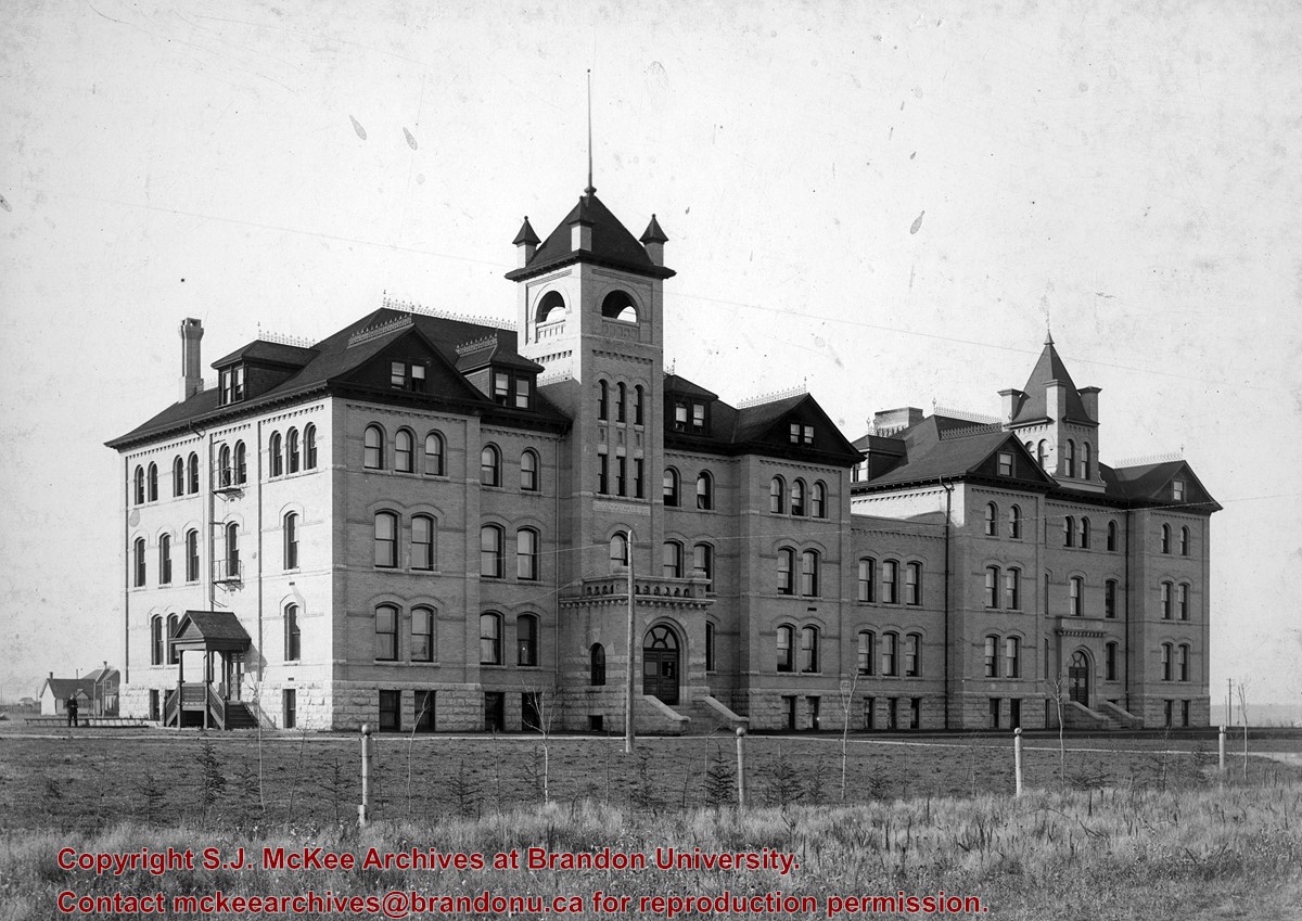
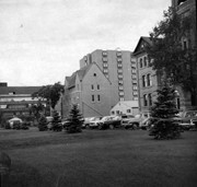
View is southwest and shows a portion of the Brandon College Building, an H-Hut, the Citizens' Science Building, McMaster Hall and the John R. Brodie Science Centre, as well as a number of parked cars. Photograph was taken on the lawn in front of Clark Hall.
Images
Show Less
Part Of
Jeff Umphrey Memorial Centre
Description Level
Item
GMD
graphic
Date Range
c. 1970
Part Of
Jeff Umphrey Memorial Centre
Description Level
Item
Series Number
2.11
Item Number
2.11.7
GMD
graphic
Date Range
c. 1970
Physical Description
8" x 10" (b/w)
Scope and Content
Photograph shows the interior of Campus Books, which was located on the lower level of the Jeff Umphrey Memorial Centre.
Show Less

20 records – page 10 of 1.