Skip header and navigation

Revise Search

20 records – page 1 of 1.

Part Of
Brandon University Photograph collection
Description Level
Item
GMD
graphic
Date Range
[1960-1961]
Part Of
Brandon University Photograph collection
Description Level
Item
Series Number
2.4
Item Number
BUPC 2.4.5
GMD
graphic
Date Range
[1960-1961]
Physical Description
5" x 7" (colour)
Scope and Content
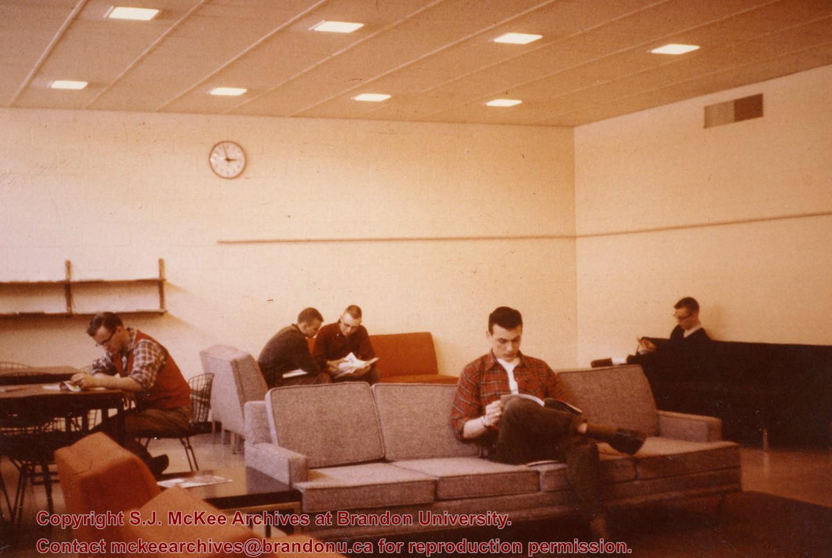
Photograph shows a number of students reading in the Men's Lounge in the A.E. McKenzie Building (Arts and Library Building). The lounge was located in the basement of the building.
Images
Show Less
Part Of
H-Huts
Description Level
Item
GMD
graphic
Date Range
c. 1975
Part Of
H-Huts
Description Level
Item
Series Number
2.13
Item Number
2.13.2
GMD
graphic
Date Range
c. 1975
Physical Description
8" x 10" (b/w)
Scope and Content
Photograph is looking west southwest approximately from the driveway and shows one of the H-Huts. In this photograph the H-Hut was a science laboratory. It later became Student Services (c. 1980) and was removed from campus in the 1990s.
Notes
The H-Hut running north-south in the background beside the Citzens' Science Building was demolished c. 1987.
Show Less
Part Of
H-Huts
Description Level
Item
GMD
graphic
Date Range
c. 1975
Part Of
H-Huts
Description Level
Item
Series Number
2.13
Item Number
2.13.3
GMD
graphic
Date Range
c. 1975
Physical Description
8" x 10" (b/w)
Scope and Content
Photograph is looking west southwest approximately from the driveway and shows one of the H-Huts. In this photograph the H-Hut was a science laboratory. At one point it also housed the Geology Annex. It later became Student Services (c. 1980) and was removed from campus in the 1990s. McMaster Hall is in the background.
Show Less

Aerial view: Brandon College campus

http://archives.brandonu.ca/en/permalink/descriptions8272
Part Of
Aerial views and campus photographs
Description Level
Item
GMD
graphic
Date Range
c. 1964
Part Of
Aerial views and campus photographs
Description Level
Item
Series Number
2.1
Item Number
2.1.1
GMD
graphic
Date Range
c. 1964
Physical Description
4" x 5" (b/w)
Scope and Content
Photograph is looking northwest from approximately the southeast corner of 18th Street and Louise Avenue.
Name Access
Flora Cowan Residence
Subject Access
Aerial views Brandon College
Images
Show Less

Aerial view: Brandon College

http://archives.brandonu.ca/en/permalink/descriptions594
Part Of
Brandon University Photograph collection
Description Level
Item
GMD
graphic
Date Range
[fall 1964?]
Part Of
Brandon University Photograph collection
Description Level
Item
Series Number
2.1
Item Number
BUPC 2.1.2
GMD
graphic
Date Range
[fall 1964?]
Physical Description
5" x 4" (b/w)
Scope and Content
Brandon College looking south from 19th Street. Photograph was taken after Flora Cowan Hall was built but before construction of the Education Building.
Subject Access
aerial photographs
campus photographs
campus buildings
Brandon streets
Images
Show Less

Continuing Education H-Hut

http://archives.brandonu.ca/en/permalink/descriptions3022
Part Of
H-Huts
Description Level
Item
GMD
graphic
Date Range
May 1978
Part Of
H-Huts
Description Level
Item
Series Number
2.13
Item Number
2.13.4
GMD
graphic
Date Range
May 1978
Physical Description
3.5" x 5" (colour)
Scope and Content
Photograph is looking west from the east side of the driveway and shows the Continuing Education H-Hut, which was located between the Brandon College Building and the Citzens' Science Building.
Show Less

Student Services H-Hut

http://archives.brandonu.ca/en/permalink/descriptions891
Part Of
H-Huts
Description Level
Item
GMD
graphic
Date Range
May 1981
Part Of
H-Huts
Description Level
Item
Series Number
2.13
Item Number
2.13.1
GMD
graphic
Date Range
May 1981
Physical Description
8" x 10" (b/w)
History / Biographical
The Student Services H-Hut was located between the Brandon College Building and the Citzens' Science Building. It was placed there c. 1950 and it was removed sometime in the 1990s. Originally the H-Hut in this photograph was the Geology Depatment, housing offices, classrooms and the lab.
Scope and Content
Photograph is looking west and shows the entrance to the Student Services H-Hut.
Notes
History/Bio information from Tom Mitchell and Harvey Young.
Show Less

Aerial view - Brandon College looking southwest

http://archives.brandonu.ca/en/permalink/descriptions601
Part Of
Brandon University Photograph collection
Description Level
Item
GMD
graphic
Date Range
[1963-1966]
Part Of
Brandon University Photograph collection
Description Level
Item
Series Number
2.1
Item Number
BUPC 2.1.8
GMD
graphic
Date Range
[1963-1966]
Physical Description
5" x 4" (b/w)
Scope and Content
Image shows the Brandon College campus from 17th Street looking southwest. The photo was taken after the completion of the original Music Building in 1963, but construction of the Education Building. Also visible are a number of properties on the 200 block of 18th Street and the 200 block of 20th Street.
Subject Access
aerial photographs
campus photographs
campus buildings
Brandon streets
Images
Show Less

Aerial view: Brandon College from 23rd Street

http://archives.brandonu.ca/en/permalink/descriptions602
Part Of
Brandon University Photograph collection
Description Level
Item
GMD
graphic
Date Range
[1963-1966]
Part Of
Brandon University Photograph collection
Description Level
Item
Series Number
2.1
Item Number
BUPC 2.1.9
GMD
graphic
Date Range
[1963-1966]
Physical Description
5" x 4" (b/w)
Scope and Content
Image is looking east northeast from approximately the 300 block of 23rd Street between Lorne and Louise Avenues. Photograph shows the Brandon College campus after the opening of the original Music Building in 1963, but before the construction of the Education Building in 1966. A number of house on the 300 blocks of 22nd and 21st Streets are visible in the foreground, with the A.E. McKenzie Seed Co., the Prince Edward Hotel and various grain elevators on the horizon.
Subject Access
aerial photographs
campus photographs
campus buildings
Brandon streets
Grain elevators
Images
Show Less

Brandon College campus

http://archives.brandonu.ca/en/permalink/descriptions727
Part Of
Aerial views and campus photographs
Description Level
Item
GMD
graphic
Date Range
c. 1961
Part Of
Aerial views and campus photographs
Description Level
Item
Series Number
2.1
Item Number
2.1.145
GMD
graphic
Date Range
c. 1961
Physical Description
3.5" x 5" (colour)
Material Details
Kodak paper
Scope and Content
Photograph is looking northwest probably from the northwest corner of 18th Street and Louise Avenue. The photographer was laying down when s/he took the shot. Photograph shows the field to the south of the Citizens' Science Building, as well as the Citizens' Science Building, part of the Brandon College Building and Clark Hall, and two H-Huts. The photo was taken in summer as the field is full of dandelions.
Images
Show Less

Brandon College campus

http://archives.brandonu.ca/en/permalink/descriptions819
Part Of
Aerial views and campus photographs
Description Level
Item
GMD
graphic
Date Range
c. 1960s
Part Of
Aerial views and campus photographs
Description Level
Item
Series Number
2.1
Item Number
2.1.51
GMD
graphic
Date Range
c. 1960s
Physical Description
10" x 8" (b/w)
Scope and Content
View is southwest. Photograph shows Clark Hall, the Brandon College Building, the Citizens' Science Building and the driveway running in front of the buildings. Portions of the front lawn and the Kinsmen Staduim are also visible.
Images
Show Less

Brandon College campus

http://archives.brandonu.ca/en/permalink/descriptions916
Part Of
Aerial views and campus photographs
Description Level
Item
GMD
graphic
Date Range
c. 1966
Part Of
Aerial views and campus photographs
Creator
Miles Photos
Description Level
Item
Series Number
2.1
Item Number
2.1.53
GMD
graphic
Date Range
c. 1966
Physical Description
10" x 8" (b/w)
Scope and Content
View is northwest from the front lawn. Photograph shows the Citizens' Science Building, an H-Hut, the Brandon College Building, Clark Hall and the original Music Building.
Images
Show Less

Brandon College campus

http://archives.brandonu.ca/en/permalink/descriptions956
Part Of
Aerial views and campus photographs
Description Level
Item
GMD
graphic
Date Range
c. 1950s
Part Of
Aerial views and campus photographs
Description Level
Item
Series Number
2.1
Item Number
2.1.44
GMD
graphic
Date Range
c. 1950s
Physical Description
7" x 5" (b/w)
Scope and Content
View is south southwest from approximatley the location of the current Health Studies Complex. Photograph shows the large field to the north of Clark Hall, Clark Hall, the Brandon College Building, the Citizens' Science Building and an H-Hut behind Clark Hall.
Show Less

Aerial view: Brandon College campus

http://archives.brandonu.ca/en/permalink/descriptions8052
Part Of
Aerial views and campus photographs
Description Level
Item
GMD
graphic
Date Range
c. 1963
Part Of
Aerial views and campus photographs
Description Level
Item
Series Number
2.1
Item Number
2.1.121
GMD
graphic
Date Range
c. 1963
Physical Description
10" x 8" (b/w)
Scope and Content
View is southwest from the northeast corner of the Brandon College campus. Flora Cowan Hall is under construction.
Images
Show Less

Aerial view: Brandon College campus

http://archives.brandonu.ca/en/permalink/descriptions8055
Part Of
Aerial views and campus photographs
Description Level
Item
GMD
graphic
Date Range
c. 1963
Part Of
Aerial views and campus photographs
Description Level
Item
Series Number
2.1
Item Number
2.1.124
GMD
graphic
Date Range
c. 1963
Physical Description
8" x 10" (b/w)
Physical Condition
A problem during development has obscured a portion of Kinsmen Stadium and the southeast corner of the campus.
Scope and Content
View is north from Victoria Avenue between 18th and 20th Streets to the railway tracks. Photograph shows Kinsmen Stadium, the College campus and a number of residential blocks.
Images
Show Less

Aerial view: Brandon College campus

http://archives.brandonu.ca/en/permalink/descriptions8056
Part Of
Aerial views and campus photographs
Description Level
Item
GMD
graphic
Date Range
c. 1963
Part Of
Aerial views and campus photographs
Description Level
Item
Series Number
2.1
Item Number
2.1.125
GMD
graphic
Date Range
c. 1963
Physical Description
10" x 8" (b/w)
Scope and Content
View is northeast from approximately the southwest corner of Victoria Avenue and 22nd Street to the Assiniboine River near 1st Street. Photograph shows the College campus, Kinsmen Stadium, residential blocks, downtown and the railway tracks.
Images
Show Less

Aerial view: Brandon College campus

http://archives.brandonu.ca/en/permalink/descriptions8063
Part Of
Aerial views and campus photographs
Description Level
Item
GMD
graphic
Date Range
c. 1963
Part Of
Aerial views and campus photographs
Description Level
Item
Series Number
2.1
Item Number
2.1.132
GMD
graphic
Date Range
c. 1963
Physical Description
10" x 8" (b/w)
Scope and Content
View is northwest from the 400 block of 18th Street to the corner of 23rd Street and Rosser Avenue. Photograph shows the Brandon College campus (Flora Cowan Hall under construction) and residential blocks.
Images
Show Less

Brandon College north driveway entrance

http://archives.brandonu.ca/en/permalink/descriptions8070
Part Of
Aerial views and campus photographs
Description Level
Item
GMD
graphic
Date Range
c. 1964
Part Of
Aerial views and campus photographs
Description Level
Item
Series Number
2.1
Item Number
2.1.139
GMD
graphic
Date Range
c. 1964
Physical Description
10" x 8" (b/w)
Scope and Content
View is southwest from the north side of Princess Avenue. Photograph shows the north driveway entrance on campus. The original Music Building, the A.E. McKenzie Building, Clark Hall and part of the Brandon College Building are visible.
Images
Show Less

Aerial view: Brandon College Building

http://archives.brandonu.ca/en/permalink/descriptions606
Part Of
Aerial views and campus photographs
Description Level
Item
GMD
graphic
Date Range
c. 1988
Part Of
Aerial views and campus photographs
Description Level
Item
Series Number
2.1
Item Number
2.1.13
GMD
graphic
Date Range
c. 1988
Physical Description
3.5" x 5" (colour)
Scope and Content
View is north northeast. Photograph shows the Brandon College Building in the foreground with the Education Building and North Hill in the background. Photo was taken from the roof of McMaster Hall.
Images
Show Less

Aerial view: Brandon College campus

http://archives.brandonu.ca/en/permalink/descriptions622
Part Of
Aerial views and campus photographs
Description Level
Item
GMD
graphic
Date Range
c. 1962
Part Of
Aerial views and campus photographs
Description Level
Item
Series Number
2.1
Item Number
2.1.20
GMD
graphic
Date Range
c. 1962
Physical Description
10" x 8" (b/w)
Scope and Content
View is northwest from approximately the corner of 18th Street and Louise Avenue. Photograph shows the Brandon College campus after the completion of Flora Cowan Hall.
Notes
BUPC 2.1.24 is a smaller version of this photograph.
Images
Show Less

20 records – page 1 of 1.