The Birtle Indian Residential School was opened by the Presbyterian Mission on December 3, 1888. Prior to that date, there had been a school allocated within the Birtle district for the Bird-Tail Sioux within Treaty 4. The new boarding school was located within the town limits of Birtle along the Bird-Tail River. The school was made of stone, was three stories high (not counting the basement), and was designed to accommodate fifty students. Connected to the school was thirty acres of land. The main building consisted of the school room, refectory, kitchen, and boys and girls dormitory. Besides the main school building, there was a barn that could accommodate fifteen head of cattle, a root-house and a small shed in which the parents would keep their ponies in the winter when they would come to visit the children. In the front of the residence there was a square piece of ground fenced off which consisted of a lawn and flower garden. The back of the residence was graveled for twenty yards. A garden of four acres was also connected with the school where vegetables were grown for use at the school.
Upon the opening of the school, there was considerable opposition on behalf of the parents as to the children being lodged and boarded such a substantial distance away from the greater Native population. This dissipated as the school gained acceptance within the Native community and attendance gradually increased as a result.
The headmaster at the original Bird-Tail school at the time of its assimilation into the Birtle Indian Residential School was J.D. Burgess. The first principle of the Birtle Indian Residential School was Rev. G.G. McLaren. He held the position from 1888 until November 1894, when he was replaced by Neil Gilmour. William J. Small became principle in 1896, and remained in that position until 1901.
The principal studies at the school were reading, writing, arithmetic, spelling and drawing. Although there were no trades associated with the school, the students were instructed in basic industries. The students also received moral training at the boarding schools. Girls were instructed in the branches of housework (washing, ironing, scrubbing , baking, cooking, sewing, knitting, tailoring, dressmaking, milking and butter-making). Boys were instructed in gardening, caring for stock, sawing, chopping and splitting wood, and were expected to help with the carpentry needs around the building. Special attention was also given to ethics and speaking English in class. There was also extensive religious training. Students were expected to attend church at least once each Sabbath in addition to their morning and evening worship and the study of the Bible and catechism in class.
During the summer the students participated in an abundance of outdoor exercise and recreation. The boys played a variety of sports, including baseball and soccer. The girls were allowed to go on long walks in the country or were given free time outdoors to take part in whatever they desired. Certain students exhibited a musical flare by playing instruments such as the madolin or the harmonica. One student, Hugh McKay, even worked part time at the local printing press during his tenure at the school. In the winter, students participated in ice-skating twice a week and the boys were allowed to play football for an hour a day. The girls could go on their walks and two or three times a week were taken for a drive a few miles into the country. There were two large playrooms within the main building for use during bad weather or when it was too cold outside for recreation during the winter.
Custodial History
Fonds was accessioned by the McKee Archives in 1997. Prior custodial history is unknown.
Scope and Content
Fonds consists of one attendance register from the Birtle Indian Residential School for the years 1888-1898. The total number of students within the register is 133. The attendance record covers the student's name, the date of their admission , their age, "full or half blood" Native status, tribe (ie. Sioux), band (ie. Bird-Tail Sioux), parents' names and father's rank, whether the parents were living or dead, parents' religion, places and periods of previous education and educational level of the student at the time of their registration. The average annual attendance at the school was forty-five students.
Students include (listed in the order in which they appear in the register): Elizabeth Benjamin; Arthur Johnston; Hagar Bunntec; Susan Hunter; Julia Eastman; Dayar David; Charlie Hanchia; Louis Eastman; Andrew Ben; Irad Bunn; Cilas Bohha; Ellen Benjamin; Carolyn Simpson; Joseph Charles; Esau Thunder; Odes Thunder; Maggie Ben; Angus Bone; Duncan Burgess; Nobaire Bone; Susan Gambler; Hugh McKay; George Bird; Mary Boyer; Alice Matheson; William Bone; Jeremiah Bone; Thomas Blackbird; Ellen Bone; Dwight Gambler; Joseph Ben; Smauel Benjamin; Charlie Cote; James Cote; Elizabeth Bone; Peter Ondie Burgess; Gilbert Walker; Frances Enoch; Isabel McKay; Norman Brandon; Jessie Brandon; Rosie Morrisau; Alex Tanner; Francis Tanner; Charlie Tanner; Jane Bone; Willis Boyer; Joseph Tanner; Gilbert Boyer; Mary Jane Tanner; Archy McDonald; Katie Brown; Bessie Brown; Tina Siaton; John Hunter; Nora Best; Lexy Smith; Nannie Jandrew; Eva Hunter; Anne Ben; Marisha Thunder; Ralph Kerr; Maggie Cook; Frank Sealton; Louis Chisholm; Lydia Nakaloo; Agnes Minnie; John Assinnewasis; Lizzie Sunguish; Hattie Sunguish; Jim Takakowewewe; Horace Takakowewewe; Nillie Yellowbird; Elizabeth Nakatoo; Alexander Brandon; Fred Brandon; Susan Blackbird; Jacob Blackbird; Harry Menlick Manshuse; Ellen McKay; George Hunter; Herbert Menlick Oliver; Flora Bird; Lucy Takakowewewe; Amos Hui Naste; Younge Singus; Susette Blackbird; Nellie Bunn; Daisy Bunn; Victoria Brandon; Janet Ashlakeesie; Mary Nubris; Bertha Hanshnu; Laura Bone; John Desparles; Okerta Desparles; Emma Assissipenace; Maggie Bearbull; Lucy Eosisamuswa; Robert Bluebird; Willie Seaton; Cahrlie Singoosh; Seclonia Mekis; Fanny Singoosh; Birtha McWeg?; Jen Eescanigah; Ethel Messegnot; Patrick Bone; Joseph Mekas; Magie Kalropunace; Augris Mekas; Sarah Wawapenace; Walter Longelaw; Eva ShaManilo Wigwam; Elsie Blackbird; Jen Ercock; Alesi Flett; Fred Longclaws; Marie Macheantie; Annie Clare; Flossie Longclaws; Andrew Pewapucolenu; David Bunn; Elizabeth Penapeccolimee; and Peter Rattlesnake.
Notes
Description by Cory Anderson (1999). A copy of his finding aid and the essay he wrote on the Birtle Indian Residential School are located in the Birtle Industrial School fonds file (Finding aid drawer in the McKee Reading Room). The Sioux people who attended the Birtle Indian Industrial School originated in Minnesota and came to Canada following the Minnesota Sioux War of 1862. The history of the Dakota people in the Canadian Northwest is described in "The Dakota of the Canadian Northwest: Lessons for Survival" by Peter Douglas Elias (1988).
Storage Location
1997 accessions
Storage Range
1997 accessions
Related Material
Archival records RG10 from the Dept. of Indian Affairs / [microform] Issued by the Public Archives of Canada, Reference E78. C2P81 provides a link to records held in Library and Archives Canada for which microfilm copies exist in the John E. Robbins Library. The administrative records of the Birtle Indian Residential School may be found in this collection.
Image is looking east northeast from approximately the 300 block of 23rd Street between Lorne and Louise Avenues. Photograph shows the Brandon College campus after the opening of the original Music Building in 1963, but before the construction of the Education Building in 1966. A number of house on the 300 blocks of 22nd and 21st Streets are visible in the foreground, with the A.E. McKenzie Seed Co., the Prince Edward Hotel and various grain elevators on the horizon.
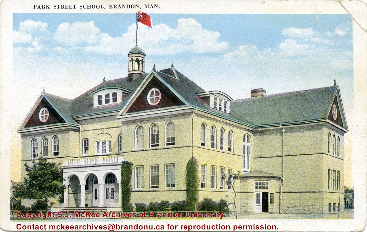
Located south of Stanley Park along the 1400 block of Lorne Avenue, Park School was constructed in 1904. Designed by W.A. Elliot and built by the Brandon Construction Company the structure measured 71 x 107 feet and cost approximately $38,000.
The school featured a principal’s office, reception room, staff rooms, an assembly hall for eight hundred, and ten class rooms. The interior walls were lined with mahogany while the floors were made of western pine. The interior of the basement was constructed from Tyndall stone, while Crookston brick trimmed with Bedford stone made up the exterior.
The building was razed in September 1978. Hobbes Manor was built on the location.
Scope and Content
Item is a postcard showing Park School in Brandon, MB.
View is northwest from the roof of the John R. Brodie Science Centre. Photograph shows the roof of the Knowles Douglas Students' Union Centre, the Citizens' Science Building, and the Brandon College Building and Clark Hall during renovation.
Photograph was taken from the roof of the Library and shows the walkway and flower bed on the southeast corner of the George T. Richardson Centre. The Physical Plant H-Hut is visible in the top right hand corner.
View is southwest from the roof of the George T. Richardson Centre. Photograph shows the curved glass wall of the John E. Robbins Library, the walkway between the Library and the Dining Hall, the Dining Hall and Darrach Hall.
View is east northeast from the sidewalk on the southeast corner of the George T. Richardson Centre (John R. Robbins Library). Photographs shows the campus during winter, including the Physical Plant and Development H-Huts, as well as the Brandon College Building and Clark Hall after the majority of the renovations were completed.
View is southwest from 18th Street, just north of the Brandon University sign. Tken during the summer, the photograph shows the front lawn, a portion of the flower bed, the Citizens' Science Building, the Knowles Douglas Students' Union Centre, the John R. Brodie Science Centre and McMaster Hall.
View is northeast. Photograph shows the green space before the Library extension in 1993. Brandon College Building and the Development H-Hut in the background.
View is northwest from the roof of the John R. Brodie Science Centre. Photograph shows part of McMaster Hall, the H-Huts, the Citzens' Science Building, the Brandon College Building and Clark Hall, the driveway, the J.R.C. Evans Lecture Theatre, the A.E. McKenzie Building and the Queen Elizabeth II Music Building.
View is northwest from the sidewalk on the west side of 18th Street. Photograph shows the John R. Brodie Science Centre sign, McMaster Hall and its entrance, the lawn in from of McMaster Hall, a portion of the Knowles Douglas Students' Union Centre and the Citizens' Science Building.
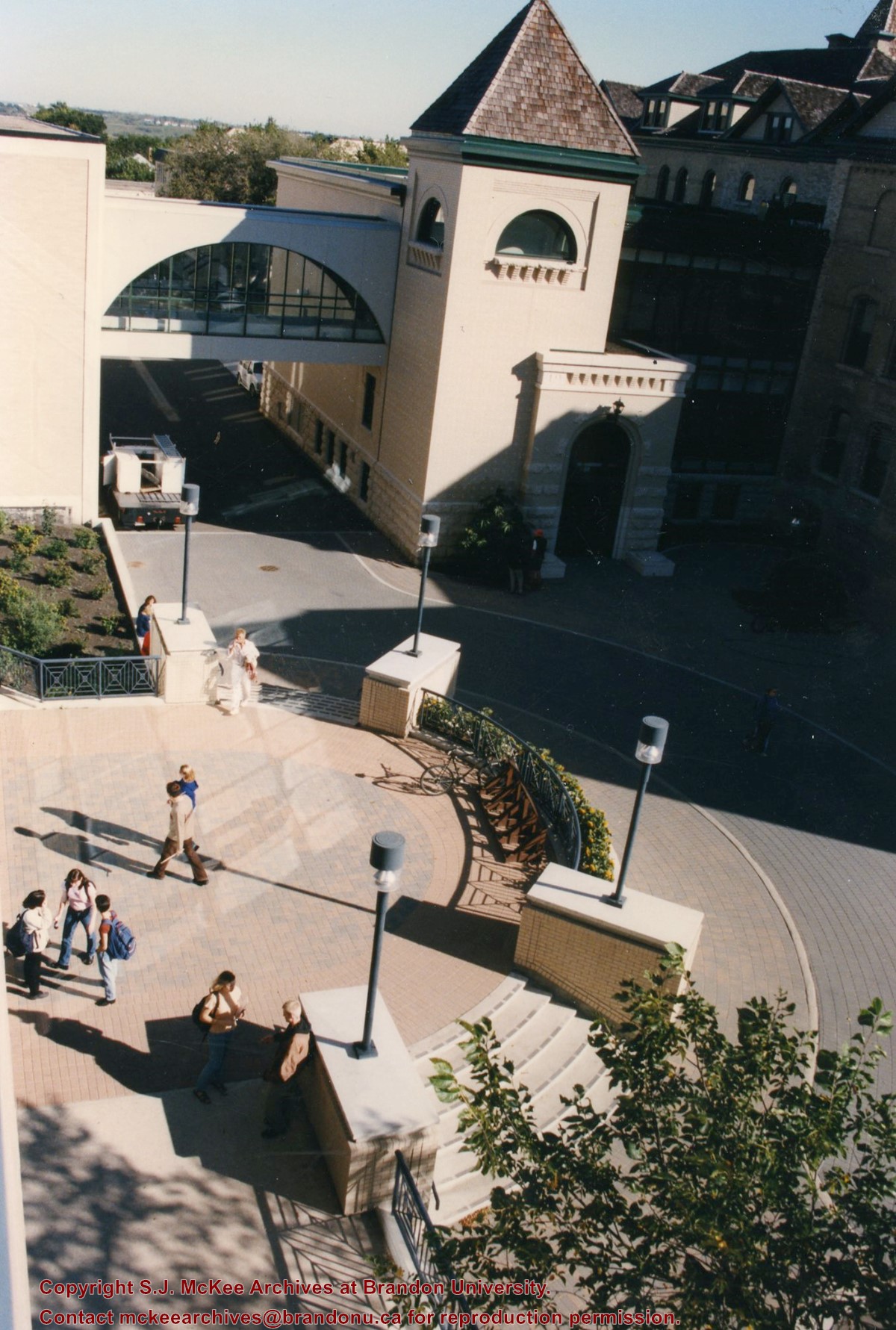
View is southwest from the corner of Clark Hall and the Clark Hall extension. Photograph shows students entering and exiting the George T. Richardson Centre and walking through the courtyard.
View is south from appromately the skywalk. Photograph shows the walkway that runs in front of the A.E. McKenzie Building south to the George T. Richardson Centre staircase and entrance. McMaster Hall in the background.
View is north northeast from the roof of the John E. Robbins Library in the George T. Richardson Centre. Photograph shows the entrance to the Richardson Building, part of the courtyard and the Clark Hall extension.
View is northeast from in front of the John E. Robbins Library in the George T. Richardson Centre. Photograph shows the entrance to the Richardson Building, most of the courtyard, Clark Hall and its extension.
View is northeast from the roof of the George T. Richardson Centre (John E. Robbins Library). Photograph shows the courtyard and the west side of the Brandon College building and Clark Hall, as well as the Clark Hall extension and part of the skywalk.
View is east southeast from the roof of the A.E. McKenzie Building. Photograph shows the courtyard and the west side of the Brandon College Building, as well as the Citizens' Science Building and the greenspace in between the two buildings.
View is from the front steps of the Education Building looking south down the east side of the Brandon College Building and Clark Hall to the Knowles Douglas Students' Union Centre and the John R. Brodie Science Centre in the background.


